| Published in Weather / Arizona Weather Temperature |
Weather in Window Rock, Arizona
Current Conditions (Saturday, March 8, 2025 at 07:53 America/Denver time)
Temperature: 27°F (-3°C) |
Forecast Overview
Sat Mar 8 
37°F 25°F 3°C -4°C Chance of snow at various times.
detailsSun Mar 9 
50°F 30°F 10°C -1°C Sunny skies.
detailsMon Mar 10 55°F 34°F 13°C 1°C Sunny skies.
detailsTue Mar 11 
52°F 34°F 11°C 1°C Considerable cloudiness.
detailsWed Mar 12 
48°F 32°F 9°C 0°C Chance of light snow in the morning.
detailsThu Mar 13 
50°F 30°F 10°C -1°C Chance of snow after 2 pm.
detailsFri Mar 14 30°F 21°F -1°C -6°C Chance of snow until 5 pm.
detailsSat Mar 15 
39°F 19°F 4°C -7°C Mostly sunny.
detailsSun Mar 16 54°F 28°F 12°C -2°C Mostly cloudy skies.
details
Detailed Forecast
| Saturday, March 8 | sunrise: 06:38 sunset: 18:16 |
| Low around 25°F (-4°C), high around 37°F (3°C). Chance of snow early in the morning (until 8 am) and early in the afternoon (between 11 am and 2 pm). Estimated precipitation: 0.18 in (4.625 mm). Partly cloudy skies. Wind: 11 mph (17 km/h). |
| Time | Skies | Conditions | Temp | Wind | Humidity | Soil Moisture |
| 23:00 02:00 | Chance of snow. Precipitation: 0.09 in (2.25 mm). | 26°F (-4°C) | 11 mph (17 km/h) | 93% | 0.137% | |
| 02:00 05:00 | Chance of snow. Precipitation: 0.07 in (1.75 mm). | 26°F (-3°C) | 4 mph (7 km/h) | 96% | 0.138% | |
| 05:00 08:00 | Chance of light snow. Precipitation: 0.01 in (0.375 mm). | 27°F (-3°C) | 7 mph (12 km/h) | 89% | 0.139% | |
| 08:00 11:00 | Considerable cloudiness. Precipitation: 0 in (0.125 mm). | 31°F (-0°C) | 10 mph (16 km/h) | 78% | 0.155% | |
| 11:00 14:00 | Chance of light snow. Precipitation: 0 in (0.0625 mm). | 36°F (2°C) | 7 mph (12 km/h) | 62% | 0.171% | |
| 14:00 17:00 | Sunny. Precipitation: 0 in (0.0625 mm). | 36°F (2°C) | 9 mph (15 km/h) | 63% | 0.166% | |
| 17:00 20:00 | Clear. | 29°F (-1°C) | 5 mph (8 km/h) | 73% | 0.153% | |
| 20:00 23:00 | Clear. | 30°F (-1°C) | 6 mph (9 km/h) | 57% | 0.152% |
| Sunday, March 9 | sunrise: 06:37 sunset: 18:17 |
| Low around 29°F (-1°C), high around 51°F (10°C). Sunny skies. Wind: 5 mph (8 km/h). |
| Time | Skies | Conditions | Temp | Wind | Humidity | Soil Moisture |
| 23:00 02:00 | Clear. | 30°F (-1°C) | 5 mph (8 km/h) | 55% | 0.16% | |
| 02:00 05:00 | Clear. | 30°F (-1°C) | 4 mph (7 km/h) | 54% | 0.173% | |
| 05:00 08:00 | Sunny. | 34°F (1°C) | 1 mph (2 km/h) | 41% | 0.185% | |
| 08:00 11:00 | Sunny. | 42°F (6°C) | 2 mph (3 km/h) | 27% | 0.184% | |
| 11:00 14:00 | Sunny. | 48°F (9°C) | 2 mph (4 km/h) | 23% | 0.167% | |
| 14:00 17:00 | Sunny. | 50°F (10°C) | 3 mph (4 km/h) | 23% | 0.159% | |
| 17:00 20:00 | Clear. | 41°F (5°C) | 2 mph (3 km/h) | 44% | 0.154% | |
| 20:00 23:00 | Clear. | 37°F (3°C) | 1 mph (2 km/h) | 46% | 0.15% |
| Monday, March 10 | sunrise: 06:35 sunset: 18:18 |
| Low around 34°F (1°C), high around 55°F (13°C). Sunny skies. Wind: 14 mph (23 km/h). |
| Time | Skies | Conditions | Temp | Wind | Humidity | Soil Moisture |
| 23:00 02:00 | Clear. | 34°F (1°C) | 1 mph (2 km/h) | 44% | 0.144% | |
| 02:00 05:00 | Clear. | 35°F (2°C) | 2 mph (3 km/h) | 40% | 0.149% | |
| 05:00 08:00 | Sunny. | 40°F (5°C) | 2 mph (4 km/h) | 30% | 0.157% | |
| 08:00 11:00 | Sunny. | 50°F (10°C) | 9 mph (15 km/h) | 20% | 0.153% | |
| 11:00 14:00 | Sunny. | 55°F (13°C) | 14 mph (23 km/h) | 14% | 0.147% | |
| 14:00 17:00 | Sunny. | 54°F (12°C) | 14 mph (23 km/h) | 14% | 0.142% | |
| 17:00 20:00 | A few passing clouds. | 45°F (7°C) | 9 mph (14 km/h) | 26% | 0.141% | |
| 20:00 23:00 | Clear. | 41°F (5°C) | 8 mph (12 km/h) | 32% | 0.139% |
| Tuesday, March 11 | sunrise: 06:34 sunset: 18:19 |
| Low around 34°F (1°C), high around 51°F (11°C). Considerable cloudiness. Wind: 23 mph (37 km/h). |
| Time | Skies | Conditions | Temp | Wind | Humidity | Soil Moisture |
| 23:00 02:00 | Clear. | 38°F (4°C) | 7 mph (11 km/h) | 33% | 0.137% | |
| 02:00 05:00 | Clear. | 35°F (2°C) | 5 mph (8 km/h) | 36% | 0.135% | |
| 05:00 08:00 | Overcast. | 39°F (4°C) | 7 mph (11 km/h) | 32% | 0.136% | |
| 08:00 11:00 | Considerable cloudiness. | 48°F (9°C) | 19 mph (30 km/h) | 19% | 0.133% | |
| 11:00 14:00 | Overcast. | 50°F (10°C) | 20 mph (32 km/h) | 21% | 0.13% | |
| 14:00 17:00 | Considerable cloudiness. | 50°F (10°C) | 23 mph (37 km/h) | 20% | 0.129% | |
| 17:00 20:00 | Overcast. | 44°F (7°C) | 15 mph (24 km/h) | 28% | 0.128% | |
| 20:00 23:00 | Overcast. | 41°F (5°C) | 9 mph (14 km/h) | 38% | 0.127% |
| Wednesday, March 12 | sunrise: 06:32 sunset: 18:20 |
| Low around 32°F (0°C), high around 48°F (9°C). Chance of light snow early in the morning (between 5 am and 8 am). Estimated precipitation: 0.01 in (0.3125 mm). Considerable cloudiness. Wind: 16 mph (26 km/h). |
| Time | Skies | Conditions | Temp | Wind | Humidity | Soil Moisture |
| 23:00 02:00 | Overcast. | 36°F (2°C) | 15 mph (25 km/h) | 67% | 0.126% | |
| 02:00 05:00 | Overcast. | 33°F (1°C) | 12 mph (19 km/h) | 83% | 0.126% | |
| 05:00 08:00 | Chance of light snow. Precipitation: 0.01 in (0.25 mm). | 34°F (1°C) | 11 mph (17 km/h) | 88% | 0.126% | |
| 08:00 11:00 | Overcast. Precipitation: 0 in (0.0625 mm). | 39°F (4°C) | 16 mph (26 km/h) | 63% | 0.127% | |
| 11:00 14:00 | Times of sun and clouds. | 43°F (6°C) | 15 mph (24 km/h) | 51% | 0.127% | |
| 14:00 17:00 | Sunny. | 47°F (9°C) | 15 mph (25 km/h) | 38% | 0.126% | |
| 17:00 20:00 | Overcast. | 42°F (6°C) | 13 mph (20 km/h) | 55% | 0.125% | |
| 20:00 23:00 | Clear. | 37°F (3°C) | 14 mph (23 km/h) | 79% | 0.125% |
| Thursday, March 13 | sunrise: 06:31 sunset: 18:21 |
| Low around 31°F (-1°C), high around 51°F (10°C). Chance of snow after 2 pm. Estimated precipitation: 0.16 in (4.125 mm). Mostly cloudy skies. Wind: 32 mph (51 km/h). |
| Time | Skies | Conditions | Temp | Wind | Humidity | Soil Moisture |
| 23:00 02:00 | Mostly clear. | 34°F (1°C) | 11 mph (17 km/h) | 88% | 0.125% | |
| 02:00 05:00 | Overcast. | 37°F (3°C) | 21 mph (33 km/h) | 77% | 0.124% | |
| 05:00 08:00 | Overcast. | 38°F (3°C) | 20 mph (33 km/h) | 67% | 0.124% | |
| 08:00 11:00 | Sunny. | 46°F (8°C) | 28 mph (45 km/h) | 45% | 0.123% | |
| 11:00 14:00 | Overcast. | 51°F (10°C) | 32 mph (51 km/h) | 32% | 0.121% | |
| 14:00 17:00 | Chance of light snow. Precipitation: 0 in (0.125 mm). | 44°F (7°C) | 30 mph (48 km/h) | 50% | 0.121% | |
| 17:00 20:00 | Chance of light snow. Precipitation: 0 in (0.0625 mm). | 36°F (2°C) | 26 mph (41 km/h) | 81% | 0.121% | |
| 20:00 23:00 | Chance of snow. Precipitation: 0.16 in (3.9375 mm). | 31°F (-1°C) | 20 mph (32 km/h) | 92% | 0.128% |
| Friday, March 14 | sunrise: 06:30 sunset: 18:22 |
| Low around 21°F (-6°C), high around 31°F (-1°C). Chance of snow until 5 pm. Estimated precipitation: 0.17 in (4.25 mm). Considerable cloudiness. Wind: 31 mph (50 km/h). |
| Time | Skies | Conditions | Temp | Wind | Humidity | Soil Moisture |
| 23:00 02:00 | Chance of snow. Precipitation: 0.05 in (1.25 mm). | 25°F (-4°C) | 28 mph (45 km/h) | 87% | 0.127% | |
| 02:00 05:00 | Mostly cloudy. Precipitation: 0.05 in (1.25 mm). | 23°F (-5°C) | 23 mph (37 km/h) | 85% | 0.132% | |
| 05:00 08:00 | Chance of light snow. Precipitation: 0 in (0.125 mm). | 22°F (-6°C) | 25 mph (41 km/h) | 84% | 0.141% | |
| 08:00 11:00 | Chance of light snow. Precipitation: 0.02 in (0.4375 mm). | 27°F (-3°C) | 29 mph (46 km/h) | 67% | 0.152% | |
| 11:00 14:00 | Chance of light snow. Precipitation: 0.03 in (0.8125 mm). | 29°F (-1°C) | 31 mph (50 km/h) | 49% | 0.165% | |
| 14:00 17:00 | Chance of light snow. Precipitation: 0.01 in (0.3125 mm). | 28°F (-2°C) | 28 mph (45 km/h) | 47% | 0.163% | |
| 17:00 20:00 | Partly cloudy. | 24°F (-5°C) | 23 mph (37 km/h) | 59% | 0.165% | |
| 20:00 23:00 | Clear. Precipitation: 0 in (0.0625 mm). | 23°F (-5°C) | 19 mph (30 km/h) | 55% | 0.178% |
| Saturday, March 15 | sunrise: 06:28 sunset: 18:22 |
| Low around 19°F (-7°C), high around 39°F (4°C). Mostly sunny. Wind: 21 mph (33 km/h). |
| Time | Skies | Conditions | Temp | Wind | Humidity | Soil Moisture |
| 23:00 02:00 | Clear. | 20°F (-7°C) | 19 mph (31 km/h) | 59% | 0.195% | |
| 02:00 05:00 | Clear. | 20°F (-7°C) | 16 mph (26 km/h) | 63% | 0.212% | |
| 05:00 08:00 | Sunny. | 23°F (-5°C) | 21 mph (33 km/h) | 48% | 0.227% | |
| 08:00 11:00 | Sunny. | 31°F (-0°C) | 20 mph (32 km/h) | 32% | 0.233% | |
| 11:00 14:00 | Sunny. | 38°F (3°C) | 18 mph (28 km/h) | 25% | 0.213% | |
| 14:00 17:00 | Mostly sunny. | 38°F (3°C) | 17 mph (28 km/h) | 29% | 0.178% | |
| 17:00 20:00 | Overcast. | 30°F (-1°C) | 9 mph (14 km/h) | 43% | 0.157% | |
| 20:00 23:00 | Clear. | 30°F (-1°C) | 5 mph (9 km/h) | 45% | 0.152% |
| Sunday, March 16 | sunrise: 06:27 sunset: 18:23 |
| Low around 29°F (-2°C), high around 54°F (12°C). Mostly cloudy skies. Wind: 17 mph (27 km/h). |
| Time | Skies | Conditions | Temp | Wind | Humidity | Soil Moisture |
| 23:00 02:00 | Clear. | 30°F (-1°C) | 5 mph (7 km/h) | 42% | 0.157% | |
| 02:00 05:00 | Clear. | 29°F (-1°C) | 4 mph (7 km/h) | 44% | 0.166% | |
| 05:00 08:00 | Overcast. | 34°F (1°C) | 4 mph (7 km/h) | 37% | 0.178% | |
| 08:00 11:00 | Overcast. | 48°F (9°C) | 12 mph (19 km/h) | 23% | 0.171% | |
| 11:00 14:00 | Overcast. | 53°F (12°C) | 17 mph (27 km/h) | 17% | 0.159% | |
| 14:00 17:00 | Overcast. | 53°F (12°C) | 15 mph (24 km/h) | 21% | 0.152% | |
| 17:00 20:00 | Overcast. | 46°F (8°C) | 11 mph (18 km/h) | 30% | 0.148% | |
| 20:00 23:00 | Overcast. | 44°F (7°C) | 15 mph (24 km/h) | 32% | 0.145% |
Climate Chart
Places with a similar climate: Taos (NM), Gallup (NM), Cortez-Montezuma County (CO), Grand Canyon (AZ), Grants (NM), Flagstaff (AZ), Limon (CO), Durango-La Plata County (CO).
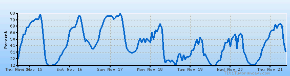
Temperature variation graph for the last seven days

Humidity Variation Graph
Wind speed

Weather Station: Window Rock, Window Rock Airport (latitude 35-39N, longitude 109-04W)
Local Time:
Window Rock is in the "America/Denver" timezone.
The "America/Denver" timezone uses a Standard Time (ST) / Daylight Saving Time (DST) alternation scheme, and it currently is in ST (since Sunday, 3 November 2024, 01:00 AM local time). During ST, the timezone abbreviation is MST and the offset to Universal Time (UTC, GMT or Zulu) is -7:00 hours.
Window Rock will exit standard time (entering DST) on Sunday, 9 March 2025, at 02:00 AM local time, when clocks will be turned forward 1 hour to Sunday, 9 March 2025, 03:00 AM local daylight time. During DST, the timezone abbreviation is MDT and the offset to UTC will be -6:00 hours.
Weather and Temperature in Arizona
Popular Weather Searches:
 If you own or manage a travel-related business such as a hotel, a bed-and-breakfast, a restaurant, a pub or a cafeteria, you can create a web page for your business for free on Titi Tudorancea Travel Info. » |