| Published in Weather / Wisconsin Weather Temperature |
Weather in Volk, Wisconsin
Current Conditions (Saturday, February 22, 2025 at 19:55 America/Chicago time)
Temperature: 25°F (-4°C) |
Forecast Overview
Sun Feb 23 
36°F 21°F 2°C -6°C Overcast skies.
detailsMon Feb 24 
48°F 36°F 9°C 2°C Mostly cloudy skies.
detailsTue Feb 25 45°F 30°F 7°C -1°C More clouds than sun.
detailsWed Feb 26 39°F 36°F 4°C 2°C Overcast skies.
detailsThu Feb 27 
37°F 27°F 3°C -3°C Chance of light snow in the morning.
detailsFri Feb 28 39°F 25°F 4°C -4°C Overcast skies.
detailsSat Mar 1 36°F 27°F 2°C -3°C Overcast skies.
detailsSun Mar 2 36°F 23°F 2°C -5°C More clouds than sun.
detailsMon Mar 3 37°F 27°F 3°C -3°C Mostly cloudy skies.
details
Detailed Forecast
| Saturday, February 22 | sunrise: 06:51 sunset: 17:38 |
| Overcast skies. Wind: 6 mph (10 km/h). |
| Time | Skies | Conditions | Temp | Wind | Humidity | Soil Moisture |
| 18:00 21:00 | Overcast. | 20°F (-7°C) | 6 mph (10 km/h) | 93% | 0.244% | |
| 21:00 00:00 | Overcast. | 20°F (-6°C) | 4 mph (7 km/h) | 93% | 0.244% |
| Sunday, February 23 | sunrise: 06:49 sunset: 17:40 |
| Low around 21°F (-6°C), high around 36°F (2°C). Overcast skies. Wind: 13 mph (20 km/h). |
| Time | Skies | Conditions | Temp | Wind | Humidity | Soil Moisture |
| 00:00 03:00 | Overcast. | 22°F (-5°C) | 3 mph (5 km/h) | 94% | 0.245% | |
| 03:00 06:00 | Overcast. | 24°F (-5°C) | 4 mph (6 km/h) | 93% | 0.245% | |
| 06:00 09:00 | More clouds than sun. | 29°F (-2°C) | 7 mph (11 km/h) | 90% | 0.245% | |
| 09:00 12:00 | Mostly cloudy. | 33°F (1°C) | 8 mph (13 km/h) | 99% | 0.266% | |
| 12:00 15:00 | Overcast. | 35°F (2°C) | 8 mph (12 km/h) | 94% | 0.289% | |
| 15:00 18:00 | Overcast. | 32°F (-0°C) | 6 mph (10 km/h) | 96% | 0.292% | |
| 18:00 21:00 | Overcast. | 33°F (0°C) | 10 mph (17 km/h) | 89% | 0.291% | |
| 21:00 00:00 | Overcast. | 36°F (2°C) | 13 mph (20 km/h) | 84% | 0.29% |
| Monday, February 24 | sunrise: 06:48 sunset: 17:41 |
| Low around 36°F (2°C), high around 47°F (9°C). Estimated precipitation: 0.02 in (0.625 mm). Mostly cloudy skies. Wind: 15 mph (24 km/h). |
| Time | Skies | Conditions | Temp | Wind | Humidity | Soil Moisture |
| 00:00 03:00 | Overcast. | 37°F (3°C) | 15 mph (24 km/h) | 79% | 0.293% | |
| 03:00 06:00 | Overcast. | 37°F (3°C) | 15 mph (24 km/h) | 82% | 0.294% | |
| 06:00 09:00 | Overcast. | 38°F (3°C) | 12 mph (19 km/h) | 88% | 0.298% | |
| 09:00 12:00 | Sunny. | 44°F (7°C) | 15 mph (24 km/h) | 73% | 0.307% | |
| 12:00 15:00 | Overcast. | 47°F (8°C) | 14 mph (23 km/h) | 60% | 0.303% | |
| 15:00 18:00 | Overcast. | 38°F (4°C) | 7 mph (11 km/h) | 85% | 0.289% | |
| 18:00 21:00 | Overcast. | 36°F (2°C) | 6 mph (10 km/h) | 92% | 0.278% | |
| 21:00 00:00 | Times of clear skies and clouds. Precipitation: 0.02 in (0.625 mm). | 37°F (3°C) | 6 mph (9 km/h) | 95% | 0.275% |
| Tuesday, February 25 | sunrise: 06:46 sunset: 17:42 |
| Low around 30°F (-1°C), high around 44°F (7°C). More clouds than sun. Wind: 8 mph (13 km/h). |
| Time | Skies | Conditions | Temp | Wind | Humidity | Soil Moisture |
| 00:00 03:00 | Clear. | 33°F (0°C) | 7 mph (12 km/h) | 94% | 0.266% | |
| 03:00 06:00 | Clear. | 30°F (-1°C) | 6 mph (10 km/h) | 96% | 0.261% | |
| 06:00 09:00 | Overcast. | 35°F (2°C) | 8 mph (13 km/h) | 82% | 0.258% | |
| 09:00 12:00 | Considerable cloudiness. | 40°F (5°C) | 7 mph (12 km/h) | 66% | 0.252% | |
| 12:00 15:00 | Partly cloudy. | 44°F (7°C) | 6 mph (10 km/h) | 59% | 0.241% | |
| 15:00 18:00 | Clear. | 39°F (4°C) | 4 mph (7 km/h) | 75% | 0.232% | |
| 18:00 21:00 | Overcast. | 35°F (2°C) | 6 mph (9 km/h) | 86% | 0.225% | |
| 21:00 00:00 | Overcast. | 35°F (2°C) | 7 mph (12 km/h) | 91% | 0.22% |
| Wednesday, February 26 | sunrise: 06:45 sunset: 17:44 |
| Low around 35°F (2°C), high around 40°F (4°C). Estimated precipitation: 0.01 in (0.1875 mm). Overcast skies. Wind: 18 mph (28 km/h). |
| Time | Skies | Conditions | Temp | Wind | Humidity | Soil Moisture |
| 00:00 03:00 | Overcast. | 38°F (4°C) | 10 mph (16 km/h) | 88% | 0.216% | |
| 03:00 06:00 | Overcast. Precipitation: 0 in (0.125 mm). | 39°F (4°C) | 10 mph (16 km/h) | 92% | 0.214% | |
| 06:00 09:00 | Overcast. | 40°F (4°C) | 14 mph (23 km/h) | 82% | 0.21% | |
| 09:00 12:00 | Overcast. Precipitation: 0 in (0.0625 mm). | 38°F (3°C) | 15 mph (25 km/h) | 88% | 0.207% | |
| 12:00 15:00 | Overcast. | 39°F (4°C) | 18 mph (28 km/h) | 74% | 0.204% | |
| 15:00 18:00 | Overcast. | 38°F (3°C) | 16 mph (26 km/h) | 72% | 0.201% | |
| 18:00 21:00 | Overcast. | 36°F (2°C) | 12 mph (20 km/h) | 77% | 0.198% | |
| 21:00 00:00 | Considerable cloudiness. | 35°F (2°C) | 10 mph (16 km/h) | 70% | 0.196% |
| Thursday, February 27 | sunrise: 06:43 sunset: 17:45 |
| Low around 27°F (-3°C), high around 38°F (3°C). Chance of light snow in the morning (between 9 am and 12 pm). Estimated precipitation: 0.01 in (0.25 mm). Considerable cloudiness. Wind: 16 mph (25 km/h). |
| Time | Skies | Conditions | Temp | Wind | Humidity | Soil Moisture |
| 00:00 03:00 | Overcast. | 32°F (0°C) | 8 mph (13 km/h) | 75% | 0.194% | |
| 03:00 06:00 | Overcast. | 31°F (-1°C) | 7 mph (12 km/h) | 82% | 0.193% | |
| 06:00 09:00 | Overcast. Precipitation: 0 in (0.0625 mm). | 34°F (1°C) | 9 mph (14 km/h) | 74% | 0.193% | |
| 09:00 12:00 | Chance of light snow. Precipitation: 0 in (0.125 mm). | 37°F (3°C) | 12 mph (20 km/h) | 78% | 0.191% | |
| 12:00 15:00 | Overcast. Precipitation: 0 in (0.0625 mm). | 37°F (3°C) | 15 mph (25 km/h) | 67% | 0.189% | |
| 15:00 18:00 | Overcast. | 33°F (1°C) | 16 mph (25 km/h) | 66% | 0.187% | |
| 18:00 21:00 | Clear. | 30°F (-1°C) | 12 mph (19 km/h) | 69% | 0.186% | |
| 21:00 00:00 | Clear. | 27°F (-3°C) | 8 mph (13 km/h) | 70% | 0.186% |
| Friday, February 28 | sunrise: 06:41 sunset: 17:46 |
| Low around 25°F (-4°C), high around 39°F (4°C). Overcast skies. Wind: 16 mph (26 km/h). |
| Time | Skies | Conditions | Temp | Wind | Humidity | Soil Moisture |
| 00:00 03:00 | Times of clear skies and clouds. | 26°F (-3°C) | 5 mph (8 km/h) | 63% | 0.189% | |
| 03:00 06:00 | Overcast. | 25°F (-4°C) | 7 mph (12 km/h) | 65% | 0.193% | |
| 06:00 09:00 | Overcast. | 28°F (-2°C) | 12 mph (19 km/h) | 55% | 0.196% | |
| 09:00 12:00 | Mostly cloudy. | 32°F (0°C) | 16 mph (26 km/h) | 57% | 0.198% | |
| 12:00 15:00 | Overcast. | 39°F (4°C) | 13 mph (20 km/h) | 57% | 0.197% | |
| 15:00 18:00 | Overcast. | 37°F (3°C) | 8 mph (13 km/h) | 71% | 0.194% | |
| 18:00 21:00 | Mostly clear, with a few passing clouds. | 39°F (4°C) | 15 mph (24 km/h) | 73% | 0.193% | |
| 21:00 00:00 | Overcast. | 33°F (0°C) | 16 mph (25 km/h) | 79% | 0.191% |
| Saturday, March 1 | sunrise: 06:40 sunset: 17:48 |
| Low around 26°F (-3°C), high around 35°F (2°C). Overcast skies. Wind: 16 mph (25 km/h). |
| Time | Skies | Conditions | Temp | Wind | Humidity | Soil Moisture |
| 00:00 03:00 | Mostly cloudy. | 31°F (-1°C) | 15 mph (24 km/h) | 76% | 0.191% | |
| 03:00 06:00 | Overcast. | 30°F (-1°C) | 13 mph (21 km/h) | 71% | 0.19% | |
| 06:00 09:00 | Overcast. | 30°F (-1°C) | 15 mph (24 km/h) | 66% | 0.191% | |
| 09:00 12:00 | Overcast. | 33°F (0°C) | 15 mph (25 km/h) | 51% | 0.19% | |
| 12:00 15:00 | Overcast. | 35°F (2°C) | 16 mph (25 km/h) | 44% | 0.186% | |
| 15:00 18:00 | Considerable cloudiness. | 30°F (-1°C) | 9 mph (15 km/h) | 54% | 0.183% | |
| 18:00 21:00 | Mostly clear. | 27°F (-3°C) | 8 mph (13 km/h) | 61% | 0.183% | |
| 21:00 00:00 | Overcast. | 26°F (-3°C) | 8 mph (13 km/h) | 61% | 0.184% |
| Sunday, March 2 | sunrise: 06:38 sunset: 17:49 |
| Low around 23°F (-5°C), high around 35°F (2°C). More clouds than sun. Wind: 9 mph (14 km/h). |
| Time | Skies | Conditions | Temp | Wind | Humidity | Soil Moisture |
| 00:00 03:00 | Overcast. | 25°F (-4°C) | 8 mph (12 km/h) | 63% | 0.187% | |
| 03:00 06:00 | Mostly clear, with a few passing clouds. | 23°F (-5°C) | 8 mph (12 km/h) | 63% | 0.191% | |
| 06:00 09:00 | Sunny. | 25°F (-4°C) | 6 mph (9 km/h) | 55% | 0.195% | |
| 09:00 12:00 | Mostly cloudy. | 31°F (-0°C) | 4 mph (7 km/h) | 39% | 0.196% | |
| 12:00 15:00 | Sunny. | 35°F (2°C) | 3 mph (4 km/h) | 34% | 0.193% | |
| 15:00 18:00 | Clear. | 29°F (-2°C) | 6 mph (10 km/h) | 47% | 0.189% | |
| 18:00 21:00 | Partly cloudy. | 27°F (-3°C) | 8 mph (12 km/h) | 60% | 0.187% | |
| 21:00 00:00 | Overcast. | 27°F (-3°C) | 9 mph (14 km/h) | 62% | 0.187% |
| Monday, March 3 | sunrise: 06:36 sunset: 17:50 |
| Low around 26°F (-3°C), high around 38°F (3°C). Mostly cloudy skies. Wind: 15 mph (24 km/h). |
| Time | Skies | Conditions | Temp | Wind | Humidity | Soil Moisture |
| 00:00 03:00 | Overcast. | 27°F (-3°C) | 11 mph (17 km/h) | 62% | 0.189% | |
| 03:00 06:00 | Clear. | 26°F (-3°C) | 12 mph (19 km/h) | 63% | 0.192% | |
| 06:00 09:00 | Considerable cloudiness. | 29°F (-2°C) | 15 mph (24 km/h) | 55% | 0.194% | |
| 09:00 12:00 | Overcast. | 35°F (2°C) | 15 mph (23 km/h) | 37% | 0.195% | |
| 12:00 15:00 | More clouds than sun. | 37°F (3°C) | 14 mph (22 km/h) | 36% | 0.192% | |
| 15:00 18:00 | Overcast. | 31°F (-1°C) | 12 mph (20 km/h) | 50% | 0.188% | |
| 18:00 21:00 | Overcast. | 28°F (-2°C) | 12 mph (19 km/h) | 57% | 0.186% | |
| 21:00 00:00 | Overcast. | 28°F (-2°C) | 10 mph (16 km/h) | 61% | 0.187% |
Climate Chart
Places with a similar climate: Wautoma (WI), Stevens Point (WI), Wisconsin Rapids, Wood County (WI), Sparta / Fort McCoy (WI), Clintonville (WI), Eau Claire, Chippewa Valley (WI), Mosinee / Central Wisconsin (WI), Big Rapids (MI), Waupaca (WI), Medford, Taylor County (WI), Ladysmith, Ruck County (WI), Rice Lake (WI), Shawano City, County (WI), New Richmond (WI), Waseca (MN), Wausau (WI), Luverne (MN), Phillips, Price County (WI), Siren, Burnett County (WI), Morrisville (VT), Baraboo (WI), Marshfield (WI), Cambridge (MN), Rush City (MN), Minneapolis / Blaine (MN).
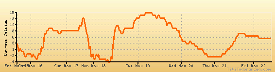
Temperature variation graph for the last seven days
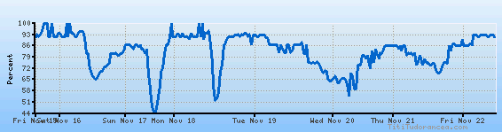
Humidity Variation Graph
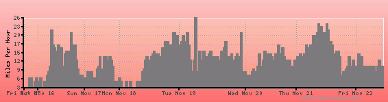
Wind speed
Weather Station: Volk / Camp Douglas (latitude 43-56N, longitude 090-16W)
Local Time:
Volk is in the "America/Chicago" timezone.
The "America/Chicago" timezone uses a Standard Time (ST) / Daylight Saving Time (DST) alternation scheme, and it currently is in ST (since Sunday, 3 November 2024, 01:00 AM local time). During ST, the timezone abbreviation is CST and the offset to Universal Time (UTC, GMT or Zulu) is -6:00 hours.
Volk will exit standard time (entering DST) on Sunday, 9 March 2025, at 02:00 AM local time, when clocks will be turned forward 1 hour to Sunday, 9 March 2025, 03:00 AM local daylight time. During DST, the timezone abbreviation is CDT and the offset to UTC will be -5:00 hours.
Weather and Temperature in Wisconsin
Popular Weather Searches:
 If you own or manage a travel-related business such as a hotel, a bed-and-breakfast, a restaurant, a pub or a cafeteria, you can create a web page for your business for free on Titi Tudorancea Travel Info. » |