| Published in Weather / Massachusetts Weather Temperature |
Weather in Taunton, Massachusetts
Current Conditions (Monday, March 17, 2025 at 13:52 America/New_York time)
Temperature: 55°F (13°C) |
Forecast Overview
Tue Mar 18 
52°F 37°F 11°C 3°C Chance of rain before sunrise.
detailsWed Mar 19 
52°F 36°F 11°C 2°C Times of sun and clouds.
detailsThu Mar 20 
57°F 37°F 14°C 3°C Mostly cloudy skies.
detailsFri Mar 21 
52°F 36°F 11°C 2°C Chance of rain until 5 pm. Chance of snow late at night.
detailsSat Mar 22 
54°F 32°F 12°C 0°C Chance of light snow before sunrise.
detailsSun Mar 23 
57°F 37°F 14°C 3°C Partly cloudy skies.
detailsMon Mar 24 
54°F 39°F 12°C 4°C Chance of rain at various times of the day.
detailsTue Mar 25 63°F 46°F 17°C 8°C Overcast skies.
detailsWed Mar 26 
55°F 39°F 13°C 4°C A few passing clouds.
details
Detailed Forecast
| Monday, March 17 | sunrise: 06:54 sunset: 18:51 |
| Chance of rain during the morning and early afternoon (between 2 am and 2 pm) and again in the evening (after 5 pm). Estimated precipitation: 0.39 in (9.9375 mm). Overcast skies. Wind: 13 mph (21 km/h). |
| Time | Skies | Conditions | Temp | Wind | Humidity | Soil Moisture |
| 14:00 17:00 | Overcast. Precipitation: 0.15 in (3.875 mm). | 53°F (12°C) | 2 mph (2 km/h) | 98% | 0.331% | |
| 17:00 20:00 | Chance of rain. Precipitation: 0.11 in (2.75 mm). | 51°F (11°C) | 13 mph (21 km/h) | 93% | 0.336% | |
| 20:00 23:00 | Chance of rain. Precipitation: 0.13 in (3.3125 mm). | 44°F (7°C) | 10 mph (16 km/h) | 91% | 0.331% |
| Tuesday, March 18 | sunrise: 06:53 sunset: 18:52 |
| Low around 37°F (3°C), high around 51°F (11°C). Chance of rain between 11 pm and 2 am. Estimated precipitation: 0.11 in (2.875 mm). Overcast skies. Wind: 12 mph (19 km/h). |
| Time | Skies | Conditions | Temp | Wind | Humidity | Soil Moisture |
| 23:00 02:00 | Chance of rain. Precipitation: 0.05 in (1.1875 mm). | 42°F (5°C) | 10 mph (16 km/h) | 92% | 0.324% | |
| 02:00 05:00 | Overcast. Precipitation: 0.06 in (1.625 mm). | 40°F (4°C) | 10 mph (17 km/h) | 86% | 0.323% | |
| 05:00 08:00 | Overcast. Precipitation: 0 in (0.0625 mm). | 39°F (4°C) | 10 mph (15 km/h) | 79% | 0.313% | |
| 08:00 11:00 | Overcast. | 45°F (7°C) | 12 mph (19 km/h) | 61% | 0.305% | |
| 11:00 14:00 | Overcast. | 49°F (10°C) | 11 mph (18 km/h) | 49% | 0.297% | |
| 14:00 17:00 | Overcast. | 47°F (8°C) | 8 mph (13 km/h) | 51% | 0.292% | |
| 17:00 20:00 | Overcast. | 39°F (4°C) | 5 mph (8 km/h) | 69% | 0.291% | |
| 20:00 23:00 | Partly cloudy. | 37°F (3°C) | 4 mph (7 km/h) | 78% | 0.291% |
| Wednesday, March 19 | sunrise: 06:51 sunset: 18:53 |
| Low around 35°F (2°C), high around 53°F (11°C). Times of sun and clouds. Wind: 8 mph (12 km/h). |
| Time | Skies | Conditions | Temp | Wind | Humidity | Soil Moisture |
| 23:00 02:00 | Clear. | 37°F (3°C) | 5 mph (8 km/h) | 82% | 0.29% | |
| 02:00 05:00 | Clear. | 36°F (2°C) | 5 mph (7 km/h) | 84% | 0.289% | |
| 05:00 08:00 | Sunny. | 39°F (4°C) | 6 mph (9 km/h) | 79% | 0.288% | |
| 08:00 11:00 | Sunny. | 50°F (10°C) | 7 mph (11 km/h) | 55% | 0.284% | |
| 11:00 14:00 | Sunny. | 52°F (11°C) | 7 mph (12 km/h) | 52% | 0.279% | |
| 14:00 17:00 | Sunny. | 49°F (10°C) | 8 mph (12 km/h) | 62% | 0.275% | |
| 17:00 20:00 | Overcast. | 39°F (4°C) | 5 mph (9 km/h) | 91% | 0.276% | |
| 20:00 23:00 | Overcast. | 39°F (4°C) | 4 mph (6 km/h) | 93% | 0.277% |
| Thursday, March 20 | sunrise: 06:49 sunset: 18:54 |
| Low around 37°F (3°C), high around 57°F (14°C). Estimated precipitation: 0 in (0.0625 mm). Mostly cloudy skies. Wind: 12 mph (19 km/h). |
| Time | Skies | Conditions | Temp | Wind | Humidity | Soil Moisture |
| 23:00 02:00 | Overcast. | 39°F (4°C) | 3 mph (4 km/h) | 94% | 0.277% | |
| 02:00 05:00 | Overcast. | 37°F (3°C) | 3 mph (4 km/h) | 98% | 0.278% | |
| 05:00 08:00 | Overcast. | 42°F (6°C) | 4 mph (7 km/h) | 91% | 0.277% | |
| 08:00 11:00 | Overcast. | 50°F (10°C) | 10 mph (15 km/h) | 80% | 0.277% | |
| 11:00 14:00 | Sunny. | 57°F (14°C) | 12 mph (19 km/h) | 69% | 0.272% | |
| 14:00 17:00 | Overcast. | 52°F (11°C) | 11 mph (18 km/h) | 80% | 0.269% | |
| 17:00 20:00 | Overcast. | 49°F (9°C) | 10 mph (17 km/h) | 85% | 0.269% | |
| 20:00 23:00 | Overcast. Precipitation: 0 in (0.0625 mm). | 48°F (9°C) | 7 mph (11 km/h) | 88% | 0.27% |
| Friday, March 21 | sunrise: 06:47 sunset: 18:56 |
| Low around 36°F (2°C), high around 51°F (11°C). Chance of rain until 5 pm. Chance of snow late at night (after 8 pm). Estimated precipitation: 0.38 in (9.6875 mm). Overcast skies. Wind: 16 mph (26 km/h). |
| Time | Skies | Conditions | Temp | Wind | Humidity | Soil Moisture |
| 23:00 02:00 | Chance of light rain. Precipitation: 0 in (0.0625 mm). | 48°F (9°C) | 4 mph (7 km/h) | 92% | 0.271% | |
| 02:00 05:00 | Chance of light rain. Precipitation: 0 in (0.125 mm). | 47°F (8°C) | 8 mph (13 km/h) | 97% | 0.272% | |
| 05:00 08:00 | Chance of light rain. Precipitation: 0.01 in (0.25 mm). | 46°F (8°C) | 9 mph (15 km/h) | 97% | 0.274% | |
| 08:00 11:00 | Chance of rain. Precipitation: 0.26 in (6.625 mm). | 47°F (9°C) | 4 mph (6 km/h) | 97% | 0.325% | |
| 11:00 14:00 | Chance of light rain. Precipitation: 0.02 in (0.625 mm). | 45°F (7°C) | 9 mph (14 km/h) | 92% | 0.304% | |
| 14:00 17:00 | Chance of rain. Precipitation: 0.04 in (1 mm). | 44°F (6°C) | 11 mph (18 km/h) | 93% | 0.302% | |
| 17:00 20:00 | Overcast. Precipitation: 0.03 in (0.875 mm). | 37°F (3°C) | 16 mph (26 km/h) | 86% | 0.298% | |
| 20:00 23:00 | Chance of light snow. Precipitation: 0 in (0.125 mm). | 36°F (2°C) | 15 mph (24 km/h) | 88% | 0.293% |
| Saturday, March 22 | sunrise: 06:46 sunset: 18:57 |
| Low around 33°F (0°C), high around 54°F (12°C). Chance of light snow between 11 pm and 2 am. Estimated precipitation: 0.02 in (0.625 mm). Partly cloudy skies. Wind: 15 mph (25 km/h). |
| Time | Skies | Conditions | Temp | Wind | Humidity | Soil Moisture |
| 23:00 02:00 | Chance of light snow. Precipitation: 0.01 in (0.375 mm). | 34°F (1°C) | 13 mph (21 km/h) | 95% | 0.29% | |
| 02:00 05:00 | Overcast. Precipitation: 0.01 in (0.25 mm). | 33°F (1°C) | 13 mph (21 km/h) | 85% | 0.288% | |
| 05:00 08:00 | Sunny. | 34°F (1°C) | 12 mph (19 km/h) | 62% | 0.285% | |
| 08:00 11:00 | Sunny. | 45°F (7°C) | 15 mph (23 km/h) | 40% | 0.28% | |
| 11:00 14:00 | Sunny. | 53°F (12°C) | 15 mph (25 km/h) | 36% | 0.274% | |
| 14:00 17:00 | Sunny. | 52°F (11°C) | 13 mph (21 km/h) | 48% | 0.269% | |
| 17:00 20:00 | Overcast. | 43°F (6°C) | 11 mph (18 km/h) | 70% | 0.268% | |
| 20:00 23:00 | Overcast. | 41°F (5°C) | 9 mph (14 km/h) | 77% | 0.269% |
| Sunday, March 23 | sunrise: 06:44 sunset: 18:58 |
| Low around 38°F (3°C), high around 58°F (14°C). Partly cloudy skies. Wind: 9 mph (15 km/h). |
| Time | Skies | Conditions | Temp | Wind | Humidity | Soil Moisture |
| 23:00 02:00 | Overcast. | 38°F (4°C) | 8 mph (13 km/h) | 82% | 0.269% | |
| 02:00 05:00 | Overcast. | 38°F (3°C) | 8 mph (12 km/h) | 77% | 0.269% | |
| 05:00 08:00 | Overcast. | 41°F (5°C) | 8 mph (13 km/h) | 69% | 0.269% | |
| 08:00 11:00 | Sunny. | 51°F (11°C) | 9 mph (15 km/h) | 46% | 0.266% | |
| 11:00 14:00 | Sunny. | 57°F (14°C) | 8 mph (13 km/h) | 41% | 0.262% | |
| 14:00 17:00 | Mostly sunny, with a few passing clouds. | 57°F (14°C) | 6 mph (10 km/h) | 42% | 0.258% | |
| 17:00 20:00 | Mostly cloudy. | 50°F (10°C) | 4 mph (6 km/h) | 64% | 0.258% | |
| 20:00 23:00 | Overcast. | 44°F (7°C) | 4 mph (6 km/h) | 72% | 0.26% |
| Monday, March 24 | sunrise: 06:42 sunset: 18:59 |
| Low around 40°F (4°C), high around 54°F (12°C). Chance of rain between 8 am and 11 am and between 2 pm and 8 pm. Estimated precipitation: 0.18 in (4.5625 mm). Overcast skies. Wind: 15 mph (24 km/h). |
| Time | Skies | Conditions | Temp | Wind | Humidity | Soil Moisture |
| 23:00 02:00 | Overcast. | 42°F (6°C) | 4 mph (6 km/h) | 76% | 0.261% | |
| 02:00 05:00 | Overcast. | 41°F (5°C) | 5 mph (8 km/h) | 75% | 0.261% | |
| 05:00 08:00 | Overcast. | 43°F (6°C) | 4 mph (6 km/h) | 79% | 0.261% | |
| 08:00 11:00 | Chance of light rain. Precipitation: 0 in (0.0625 mm). | 49°F (9°C) | 6 mph (10 km/h) | 66% | 0.261% | |
| 11:00 14:00 | Overcast. Precipitation: 0.02 in (0.5625 mm). | 50°F (10°C) | 11 mph (17 km/h) | 64% | 0.263% | |
| 14:00 17:00 | Chance of light rain. Precipitation: 0.02 in (0.5625 mm). | 48°F (9°C) | 15 mph (24 km/h) | 83% | 0.266% | |
| 17:00 20:00 | Chance of rain. Precipitation: 0.05 in (1.3125 mm). | 52°F (11°C) | 13 mph (21 km/h) | 94% | 0.274% | |
| 20:00 23:00 | Overcast. Precipitation: 0.08 in (2.0625 mm). | 53°F (12°C) | 15 mph (24 km/h) | 96% | 0.291% |
| Tuesday, March 25 | sunrise: 06:41 sunset: 19:00 |
| Low around 47°F (8°C), high around 62°F (17°C). Estimated precipitation: 0 in (0.0625 mm). Overcast skies. Wind: 12 mph (19 km/h). |
| Time | Skies | Conditions | Temp | Wind | Humidity | Soil Moisture |
| 23:00 02:00 | Overcast. Precipitation: 0 in (0.0625 mm). | 52°F (11°C) | 11 mph (18 km/h) | 94% | 0.285% | |
| 02:00 05:00 | Overcast. | 50°F (10°C) | 8 mph (12 km/h) | 97% | 0.281% | |
| 05:00 08:00 | Overcast. | 49°F (10°C) | 7 mph (11 km/h) | 96% | 0.278% | |
| 08:00 11:00 | Overcast. | 55°F (13°C) | 9 mph (14 km/h) | 71% | 0.274% | |
| 11:00 14:00 | Overcast. | 61°F (16°C) | 12 mph (19 km/h) | 41% | 0.267% | |
| 14:00 17:00 | Overcast. | 56°F (13°C) | 9 mph (14 km/h) | 53% | 0.262% | |
| 17:00 20:00 | Overcast. | 49°F (9°C) | 4 mph (6 km/h) | 73% | 0.262% | |
| 20:00 23:00 | Overcast. | 47°F (8°C) | 5 mph (8 km/h) | 75% | 0.262% |
| Wednesday, March 26 | sunrise: 06:39 sunset: 19:01 |
| Low around 40°F (4°C), high around 56°F (13°C). A few passing clouds. Wind: 13 mph (20 km/h). |
| Time | Skies | Conditions | Temp | Wind | Humidity | Soil Moisture |
| 23:00 02:00 | Clear. | 42°F (6°C) | 5 mph (8 km/h) | 84% | 0.263% | |
| 02:00 05:00 | Clear. | 40°F (4°C) | 6 mph (9 km/h) | 89% | 0.263% | |
| 05:00 08:00 | Mostly sunny. | 44°F (7°C) | 10 mph (16 km/h) | 76% | 0.263% | |
| 08:00 11:00 | Sunny. | 51°F (11°C) | 13 mph (20 km/h) | 42% | 0.259% | |
| 11:00 14:00 | Sunny. | 55°F (13°C) | 11 mph (17 km/h) | 34% | 0.253% | |
| 14:00 17:00 | Overcast. | 52°F (11°C) | 12 mph (19 km/h) | 47% | 0.249% | |
| 17:00 20:00 | Overcast. | 46°F (8°C) | 8 mph (12 km/h) | 61% | 0.249% | |
| 20:00 23:00 | Clear. | 41°F (5°C) | 5 mph (8 km/h) | 70% | 0.25% |
Climate Chart
Places with a similar climate: Willimantic (CT), Meriden (CT), Bedford, Hanscom Field (MA), Norwood (MA), Sussex (NJ), Westhampton Beach (NY), New Bedford (MA), Danbury (CT), Poughkeepsie, Dutchess County (NY), Pawtucket (RI), Plymouth (MA), Montgomery, Orange County (NY), Quakertown (PA), Nashua (NH), Windsor Locks (CT), Newburgh / Stewart (NY), Fitchburg (MA), Lawrence (MA), Andover (NJ), Selinsgrove (PA), Westfield, Barnes (MA), Beverly (MA), Washington County (PA), Morristown (NJ), Oxford (CT).
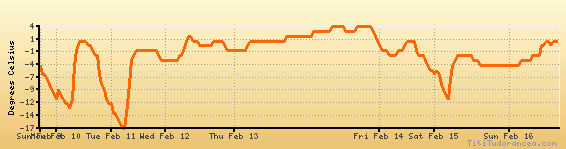
Temperature variation graph for the last seven days
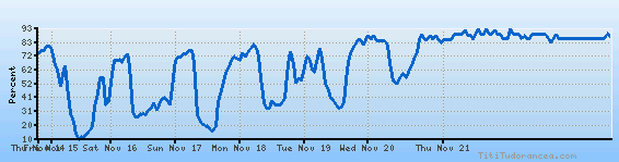
Humidity Variation Graph
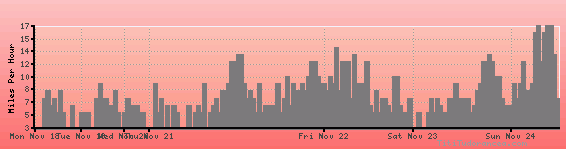
Wind speed
Weather Station: Taunton, Taunton Municipal Airport (latitude 41-52-32N, longitude 071-01-16W)
Local Time:
Taunton is in the "America/New_York" timezone.
The "America/New_York" timezone uses a Standard Time (ST) / Daylight Saving Time (DST) alternation scheme, and it currently is in DST (since Sunday, 9 March 2025, 03:00 AM local time). During DST, the timezone abbreviation is EDT and the offset to Universal Time (UTC, GMT or Zulu) is -4:00 hours.
Taunton will exit DST (returning to standard time) on Sunday, 2 November 2025, at 02:00 AM local time, when clocks will be turned backward 1 hour to Sunday, 2 November 2025, 01:00 AM local standard time. During ST, the timezone abbreviation is EST and the offset to UTC will be -5:00 hours.
Weather and Temperature in Massachusetts
Popular Weather Searches:
 If you own or manage a travel-related business such as a hotel, a bed-and-breakfast, a restaurant, a pub or a cafeteria, you can create a web page for your business for free on Titi Tudorancea Travel Info. » |