| Published in Weather / Alaska Weather Temperature |
Weather in St. Mary's, Alaska
Current Conditions (Saturday, February 1, 2025 at 13:46 America/Nome time)
Temperature: 27°F (-3°C) |
Forecast Overview
Sun Feb 2 
28°F 21°F -2°C -6°C Overcast skies.
detailsMon Feb 3 
30°F 19°F -1°C -7°C Chance of light snow after 3 pm.
detailsTue Feb 4 
34°F 30°F 1°C -1°C Chance of snow almost all day.
detailsWed Feb 5 32°F 30°F 0°C -1°C Chance of light snow at various times.
detailsThu Feb 6 
30°F 21°F -1°C -6°C Chance of snow in the afternoon.
detailsFri Feb 7 30°F 21°F -1°C -6°C Mostly cloudy skies.
detailsSat Feb 8 36°F 18°F 2°C -8°C Chance of light snow at various times.
detailsSun Feb 9 36°F 30°F 2°C -1°C Chance of snow most of the day.
detailsMon Feb 10 34°F 30°F 1°C -1°C Chance of snow all day.
details
Detailed Forecast
| Saturday, February 1 | sunrise: 10:21 sunset: 17:53 |
| Overcast skies. Wind: 12 mph (19 km/h). |
| Time | Skies | Conditions | Temp | Wind | Humidity | Soil Moisture |
| 12:00 15:00 | Overcast. | 29°F (-2°C) | 12 mph (19 km/h) | 95% | 0.439% | |
| 15:00 18:00 | Overcast. | 28°F (-2°C) | 12 mph (19 km/h) | 96% | 0.439% | |
| 18:00 21:00 | Overcast. | 27°F (-3°C) | 12 mph (19 km/h) | 94% | 0.439% | |
| 21:00 00:00 | Overcast. | 25°F (-4°C) | 12 mph (19 km/h) | 94% | 0.439% |
| Sunday, February 2 | sunrise: 10:19 sunset: 17:56 |
| Low around 21°F (-6°C), high around 28°F (-2°C). Overcast skies. Wind: 16 mph (25 km/h). |
| Time | Skies | Conditions | Temp | Wind | Humidity | Soil Moisture |
| 00:00 03:00 | Overcast. | 27°F (-3°C) | 13 mph (21 km/h) | 93% | 0.439% | |
| 03:00 06:00 | Overcast. | 26°F (-3°C) | 15 mph (24 km/h) | 92% | 0.439% | |
| 06:00 09:00 | Overcast. | 25°F (-4°C) | 15 mph (24 km/h) | 91% | 0.439% | |
| 09:00 12:00 | Overcast. | 25°F (-4°C) | 15 mph (24 km/h) | 89% | 0.439% | |
| 12:00 15:00 | Overcast. | 26°F (-3°C) | 16 mph (25 km/h) | 89% | 0.439% | |
| 15:00 18:00 | Overcast. | 24°F (-4°C) | 15 mph (24 km/h) | 89% | 0.439% | |
| 18:00 21:00 | Mostly cloudy. | 23°F (-5°C) | 15 mph (23 km/h) | 88% | 0.439% | |
| 21:00 00:00 | Overcast. | 21°F (-6°C) | 12 mph (20 km/h) | 89% | 0.439% |
| Monday, February 3 | sunrise: 10:16 sunset: 17:59 |
| Low around 19°F (-7°C), high around 31°F (-1°C). Chance of light snow after 3 pm. Estimated precipitation: 0.03 in (0.875 mm). Overcast skies. Wind: 16 mph (25 km/h). |
| Time | Skies | Conditions | Temp | Wind | Humidity | Soil Moisture |
| 00:00 03:00 | Overcast. | 20°F (-7°C) | 12 mph (19 km/h) | 89% | 0.439% | |
| 03:00 06:00 | Overcast. | 20°F (-7°C) | 13 mph (21 km/h) | 89% | 0.439% | |
| 06:00 09:00 | Overcast. | 20°F (-6°C) | 14 mph (23 km/h) | 90% | 0.439% | |
| 09:00 12:00 | Overcast. | 22°F (-5°C) | 16 mph (25 km/h) | 91% | 0.439% | |
| 12:00 15:00 | Overcast. | 27°F (-3°C) | 15 mph (24 km/h) | 94% | 0.439% | |
| 15:00 18:00 | Chance of light snow. Precipitation: 0 in (0.125 mm). | 29°F (-2°C) | 14 mph (23 km/h) | 96% | 0.439% | |
| 18:00 21:00 | Chance of light snow. Precipitation: 0.01 in (0.375 mm). | 29°F (-1°C) | 13 mph (21 km/h) | 96% | 0.439% | |
| 21:00 00:00 | Chance of light snow. Precipitation: 0.01 in (0.375 mm). | 31°F (-1°C) | 13 mph (22 km/h) | 97% | 0.439% |
| Tuesday, February 4 | sunrise: 10:13 sunset: 18:01 |
| Low around 29°F (-1°C), high around 33°F (1°C). Chance of snow most of the night and day, except early afternoon (from 12 pm to 3 pm). Estimated precipitation: 0.31 in (7.75 mm). Overcast skies. Wind: 15 mph (25 km/h). |
| Time | Skies | Conditions | Temp | Wind | Humidity | Soil Moisture |
| 00:00 03:00 | Chance of snow. Precipitation: 0.04 in (1.125 mm). | 32°F (0°C) | 15 mph (25 km/h) | 99% | 0.439% | |
| 03:00 06:00 | Chance of light snow. Precipitation: 0.02 in (0.5 mm). | 33°F (0°C) | 14 mph (22 km/h) | 97% | 0.439% | |
| 06:00 09:00 | Chance of light snow. Precipitation: 0.02 in (0.5625 mm). | 33°F (1°C) | 8 mph (13 km/h) | 99% | 0.439% | |
| 09:00 12:00 | Chance of light snow. Precipitation: 0 in (0.125 mm). | 33°F (0°C) | 6 mph (10 km/h) | 99% | 0.439% | |
| 12:00 15:00 | Overcast. Precipitation: 0 in (0.125 mm). | 33°F (0°C) | 5 mph (9 km/h) | 100% | 0.439% | |
| 15:00 18:00 | Chance of snow. Precipitation: 0.06 in (1.4375 mm). | 32°F (-0°C) | 7 mph (12 km/h) | 99% | 0.439% | |
| 18:00 21:00 | Chance of snow. Precipitation: 0.12 in (3 mm). | 32°F (0°C) | 7 mph (11 km/h) | 99% | 0.439% | |
| 21:00 00:00 | Chance of light snow. Precipitation: 0.03 in (0.875 mm). | 32°F (0°C) | 8 mph (13 km/h) | 99% | 0.439% |
| Wednesday, February 5 | sunrise: 10:11 sunset: 18:04 |
| Low around 29°F (-1°C), high around 33°F (0°C). Chance of light snow all night and all morning (until 12 pm), in the evening and again at night (after 6 pm). Estimated precipitation: 0.05 in (1.1875 mm). Overcast skies. Wind: 8 mph (13 km/h). |
| Time | Skies | Conditions | Temp | Wind | Humidity | Soil Moisture |
| 00:00 03:00 | Chance of light snow. Precipitation: 0.01 in (0.1875 mm). | 32°F (-0°C) | 6 mph (9 km/h) | 99% | 0.439% | |
| 03:00 06:00 | Chance of light snow. Precipitation: 0.01 in (0.1875 mm). | 31°F (-0°C) | 4 mph (6 km/h) | 99% | 0.439% | |
| 06:00 09:00 | Chance of light snow. Precipitation: 0 in (0.125 mm). | 31°F (-0°C) | 4 mph (7 km/h) | 99% | 0.439% | |
| 09:00 12:00 | Chance of light snow. Precipitation: 0 in (0.125 mm). | 32°F (0°C) | 6 mph (10 km/h) | 99% | 0.439% | |
| 12:00 15:00 | Overcast. Precipitation: 0 in (0.125 mm). | 32°F (0°C) | 6 mph (10 km/h) | 99% | 0.439% | |
| 15:00 18:00 | Overcast. | 31°F (-1°C) | 7 mph (11 km/h) | 98% | 0.439% | |
| 18:00 21:00 | Chance of light snow. Precipitation: 0.01 in (0.25 mm). | 30°F (-1°C) | 8 mph (12 km/h) | 98% | 0.439% | |
| 21:00 00:00 | Chance of light snow. Precipitation: 0.01 in (0.1875 mm). | 30°F (-1°C) | 8 mph (13 km/h) | 98% | 0.439% |
| Thursday, February 6 | sunrise: 10:08 sunset: 18:07 |
| Low around 21°F (-6°C), high around 31°F (-1°C). Chance of snow late in the afternoon (between 3 pm and 6 pm). Estimated precipitation: 0.08 in (2.125 mm). Mostly cloudy skies. Wind: 19 mph (31 km/h). |
| Time | Skies | Conditions | Temp | Wind | Humidity | Soil Moisture |
| 00:00 03:00 | Overcast. Precipitation: 0 in (0.0625 mm). | 30°F (-1°C) | 10 mph (16 km/h) | 97% | 0.439% | |
| 03:00 06:00 | Partly cloudy. | 26°F (-3°C) | 11 mph (18 km/h) | 96% | 0.439% | |
| 06:00 09:00 | Mostly cloudy. | 21°F (-6°C) | 11 mph (17 km/h) | 96% | 0.439% | |
| 09:00 12:00 | Overcast. | 27°F (-3°C) | 15 mph (25 km/h) | 90% | 0.439% | |
| 12:00 15:00 | Overcast. | 26°F (-3°C) | 16 mph (26 km/h) | 94% | 0.439% | |
| 15:00 18:00 | Chance of light snow. Precipitation: 0.02 in (0.625 mm). | 27°F (-3°C) | 18 mph (29 km/h) | 97% | 0.439% | |
| 18:00 21:00 | Overcast. Precipitation: 0.06 in (1.4375 mm). | 28°F (-2°C) | 18 mph (29 km/h) | 95% | 0.439% | |
| 21:00 00:00 | Overcast. | 28°F (-2°C) | 19 mph (31 km/h) | 93% | 0.439% |
| Friday, February 7 | sunrise: 10:05 sunset: 18:10 |
| Low around 21°F (-6°C), high around 31°F (-1°C). Estimated precipitation: 0.02 in (0.5 mm). Mostly cloudy skies. Wind: 20 mph (32 km/h). |
| Time | Skies | Conditions | Temp | Wind | Humidity | Soil Moisture |
| 00:00 03:00 | Overcast. Precipitation: 0.02 in (0.5 mm). | 29°F (-2°C) | 20 mph (32 km/h) | 95% | 0.439% | |
| 03:00 06:00 | Overcast. | 30°F (-1°C) | 18 mph (30 km/h) | 92% | 0.439% | |
| 06:00 09:00 | Overcast. | 31°F (-1°C) | 16 mph (26 km/h) | 91% | 0.439% | |
| 09:00 12:00 | Overcast. | 28°F (-2°C) | 13 mph (21 km/h) | 93% | 0.439% | |
| 12:00 15:00 | Overcast. | 30°F (-1°C) | 13 mph (21 km/h) | 91% | 0.439% | |
| 15:00 18:00 | Overcast. | 29°F (-2°C) | 17 mph (28 km/h) | 90% | 0.439% | |
| 18:00 21:00 | A few passing clouds. | 22°F (-5°C) | 13 mph (21 km/h) | 92% | 0.439% | |
| 21:00 00:00 | Partly cloudy. | 22°F (-6°C) | 14 mph (23 km/h) | 92% | 0.439% |
| Saturday, February 8 | sunrise: 10:02 sunset: 18:13 |
| Low around 17°F (-8°C), high around 35°F (2°C). Chance of light snow during the morning and early afternoon (between 6 am and 3 pm) and at night (after 9 pm). Estimated precipitation: 0.06 in (1.5625 mm). Overcast skies. Wind: 24 mph (39 km/h). |
| Time | Skies | Conditions | Temp | Wind | Humidity | Soil Moisture |
| 00:00 03:00 | Overcast. | 19°F (-7°C) | 13 mph (20 km/h) | 93% | 0.439% | |
| 03:00 06:00 | Overcast. | 18°F (-8°C) | 15 mph (24 km/h) | 93% | 0.439% | |
| 06:00 09:00 | Chance of light snow. Precipitation: 0.01 in (0.1875 mm). | 24°F (-4°C) | 20 mph (32 km/h) | 93% | 0.439% | |
| 09:00 12:00 | Chance of snow. Precipitation: 0.04 in (1 mm). | 27°F (-3°C) | 24 mph (38 km/h) | 93% | 0.439% | |
| 12:00 15:00 | Chance of light snow. Precipitation: 0.01 in (0.1875 mm). | 31°F (-1°C) | 24 mph (39 km/h) | 96% | 0.439% | |
| 15:00 18:00 | Overcast. Precipitation: 0 in (0.125 mm). | 35°F (2°C) | 24 mph (38 km/h) | 94% | 0.439% | |
| 18:00 21:00 | Overcast. | 35°F (2°C) | 21 mph (34 km/h) | 94% | 0.439% | |
| 21:00 00:00 | Chance of light snow. Precipitation: 0 in (0.0625 mm). | 33°F (1°C) | 22 mph (35 km/h) | 98% | 0.439% |
| Sunday, February 9 | sunrise: 09:59 sunset: 18:16 |
| Low around 30°F (-1°C), high around 35°F (2°C). Chance of snow almost all day, except between 6 pm and 9 pm. Estimated precipitation: 0.19 in (4.75 mm). Overcast skies. Wind: 26 mph (42 km/h). |
| Time | Skies | Conditions | Temp | Wind | Humidity | Soil Moisture |
| 00:00 03:00 | Chance of light snow. Precipitation: 0 in (0.125 mm). | 33°F (1°C) | 25 mph (41 km/h) | 85% | 0.439% | |
| 03:00 06:00 | Overcast. Precipitation: 0.01 in (0.1875 mm). | 33°F (1°C) | 23 mph (37 km/h) | 80% | 0.439% | |
| 06:00 09:00 | Chance of light snow. Precipitation: 0.01 in (0.3125 mm). | 32°F (0°C) | 25 mph (40 km/h) | 95% | 0.439% | |
| 09:00 12:00 | Chance of light snow. Precipitation: 0.03 in (0.875 mm). | 34°F (1°C) | 26 mph (42 km/h) | 88% | 0.439% | |
| 12:00 15:00 | Chance of snow. Precipitation: 0.04 in (1 mm). | 34°F (1°C) | 22 mph (36 km/h) | 84% | 0.439% | |
| 15:00 18:00 | Chance of snow. Precipitation: 0.06 in (1.5 mm). | 32°F (-0°C) | 20 mph (32 km/h) | 96% | 0.439% | |
| 18:00 21:00 | Mostly cloudy. Precipitation: 0.01 in (0.3125 mm). | 31°F (-0°C) | 20 mph (32 km/h) | 88% | 0.439% | |
| 21:00 00:00 | Chance of light snow. Precipitation: 0.02 in (0.4375 mm). | 31°F (-1°C) | 19 mph (30 km/h) | 97% | 0.439% |
| Monday, February 10 | sunrise: 09:56 sunset: 18:19 |
| Low around 30°F (-1°C), high around 34°F (1°C). Chance of snow all day. Estimated precipitation: 0.42 in (10.5625 mm). Overcast skies. Wind: 27 mph (44 km/h). |
| Time | Skies | Conditions | Temp | Wind | Humidity | Soil Moisture |
| 00:00 03:00 | Chance of light snow. Precipitation: 0 in (0.125 mm). | 32°F (0°C) | 17 mph (27 km/h) | 87% | 0.439% | |
| 03:00 06:00 | Overcast. | 33°F (0°C) | 16 mph (26 km/h) | 87% | 0.439% | |
| 06:00 09:00 | Chance of snow. Precipitation: 0.09 in (2.3125 mm). | 32°F (0°C) | 19 mph (31 km/h) | 99% | 0.439% | |
| 09:00 12:00 | Chance of snow. Precipitation: 0.08 in (2.125 mm). | 34°F (1°C) | 27 mph (44 km/h) | 89% | 0.439% | |
| 12:00 15:00 | Chance of snow. Precipitation: 0.04 in (1.125 mm). | 33°F (1°C) | 25 mph (40 km/h) | 97% | 0.439% | |
| 15:00 18:00 | Chance of snow. Precipitation: 0.04 in (1.125 mm). | 33°F (1°C) | 20 mph (31 km/h) | 98% | 0.439% | |
| 18:00 21:00 | Chance of snow. Precipitation: 0.09 in (2.1875 mm). | 33°F (0°C) | 16 mph (26 km/h) | 99% | 0.439% | |
| 21:00 00:00 | Chance of snow. Precipitation: 0.06 in (1.5625 mm). | 33°F (0°C) | 12 mph (19 km/h) | 99% | 0.439% |
Climate Chart
Places with a similar climate: Mountain Village, Wade Hampton (AK), St Michael, Nome, Alaska (AK), Marshall City, Wade Hampton, Alaska (AK), Emmonak (AK), Koyuk (AK), Scammon Bay, Wade Hampton, Alaska (AK), Unalakleet (AK), Nome (AK), Bethel (AK), Kipnuk (AK).
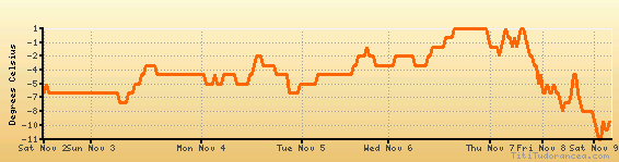
Temperature variation graph for the last seven days
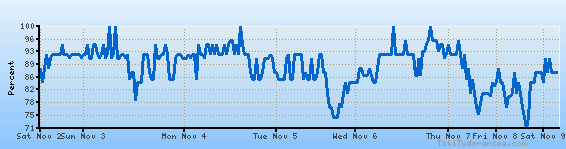
Humidity Variation Graph
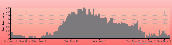
Wind speed
Weather Station: St. Mary's, St. Mary's Airport (latitude 62-03N, longitude 163-18W)
Local Time:
St. Mary's is in the "America/Nome" timezone.
The "America/Nome" timezone uses a Standard Time (ST) / Daylight Saving Time (DST) alternation scheme, and it currently is in ST (since Sunday, 3 November 2024, 01:00 AM local time). During ST, the timezone abbreviation is AKST and the offset to Universal Time (UTC, GMT or Zulu) is -9:00 hours.
St. Mary's will exit standard time (entering DST) on Sunday, 9 March 2025, at 02:00 AM local time, when clocks will be turned forward 1 hour to Sunday, 9 March 2025, 03:00 AM local daylight time. During DST, the timezone abbreviation is AKDT and the offset to UTC will be -8:00 hours.
Weather and Temperature in Alaska
Popular Weather Searches:
 If you own or manage a travel-related business such as a hotel, a bed-and-breakfast, a restaurant, a pub or a cafeteria, you can create a web page for your business for free on Titi Tudorancea Travel Info. » |