| Published in Weather / South Dakota Weather Temperature |
Weather in Sisseton, South Dakota
Current Conditions (Saturday, March 29, 2025 at 03:56 America/Chicago time)
Temperature: 34°F (1°C) |
Forecast Overview
Sat Mar 29 
37°F 32°F 3°C 0°C Chance of snow after 1 pm.
detailsSun Mar 30 
37°F 28°F 3°C -2°C Chance of snow in the morning.
detailsMon Mar 31 
37°F 23°F 3°C -5°C More clouds than sun.
detailsTue Apr 1 
34°F 28°F 1°C -2°C Chance of rain late at night. Chance of snow until 7 pm.
detailsWed Apr 2 36°F 32°F 2°C -0°C Chance of rain in the morning. Chance of snow after 7 pm.
detailsThu Apr 3 
41°F 32°F 5°C -0°C Chance of light rain after 7 pm.
detailsFri Apr 4 
55°F 36°F 13°C 2°C Chance of rain before sunrise.
detailsSat Apr 5 
64°F 43°F 18°C 6°C Sunny skies.
detailsSun Apr 6 55°F 41°F 13°C 5°C Sunny skies.
details
Detailed Forecast
| Saturday, March 29 | sunrise: 07:16 sunset: 19:50 |
| Low around 32°F (0°C), high around 37°F (3°C). Chance of snow from 1 pm till 1 am. Estimated precipitation: 0.34 in (8.75 mm). Overcast skies. Wind: 13 mph (21 km/h). |
| Time | Skies | Conditions | Temp | Wind | Humidity | Soil Moisture |
| 01:00 04:00 | Overcast. | 34°F (1°C) | 12 mph (19 km/h) | 87% | 0.225% | |
| 04:00 07:00 | Overcast. | 34°F (1°C) | 10 mph (16 km/h) | 87% | 0.225% | |
| 07:00 10:00 | Overcast. | 35°F (2°C) | 12 mph (19 km/h) | 82% | 0.224% | |
| 10:00 13:00 | Overcast. | 37°F (3°C) | 10 mph (15 km/h) | 73% | 0.224% | |
| 13:00 16:00 | Chance of snow. Precipitation: 0.06 in (1.5 mm). | 35°F (2°C) | 13 mph (21 km/h) | 85% | 0.232% | |
| 16:00 19:00 | Chance of snow. Precipitation: 0.09 in (2.1875 mm). | 33°F (1°C) | 11 mph (18 km/h) | 97% | 0.242% | |
| 19:00 22:00 | Chance of snow. Precipitation: 0.1 in (2.5 mm). | 33°F (1°C) | 11 mph (18 km/h) | 98% | 0.249% | |
| 22:00 01:00 | Chance of snow. Precipitation: 0.1 in (2.5625 mm). | 32°F (0°C) | 12 mph (19 km/h) | 99% | 0.254% |
| Sunday, March 30 | sunrise: 07:14 sunset: 19:52 |
| Low around 28°F (-2°C), high around 37°F (3°C). Chance of snow early in the morning (until 10 am). Estimated precipitation: 0.13 in (3.375 mm). Overcast skies. Wind: 16 mph (26 km/h). |
| Time | Skies | Conditions | Temp | Wind | Humidity | Soil Moisture |
| 01:00 04:00 | Chance of snow. Precipitation: 0.07 in (1.875 mm). | 32°F (-0°C) | 13 mph (21 km/h) | 98% | 0.255% | |
| 04:00 07:00 | Chance of light snow. Precipitation: 0.03 in (0.8125 mm). | 30°F (-1°C) | 13 mph (21 km/h) | 96% | 0.251% | |
| 07:00 10:00 | Chance of light snow. Precipitation: 0.02 in (0.625 mm). | 31°F (-0°C) | 16 mph (25 km/h) | 95% | 0.251% | |
| 10:00 13:00 | Overcast. Precipitation: 0 in (0.0625 mm). | 34°F (1°C) | 15 mph (24 km/h) | 82% | 0.26% | |
| 13:00 16:00 | Overcast. | 36°F (2°C) | 15 mph (25 km/h) | 80% | 0.267% | |
| 16:00 19:00 | Overcast. | 35°F (2°C) | 16 mph (26 km/h) | 73% | 0.265% | |
| 19:00 22:00 | Overcast. | 32°F (-0°C) | 15 mph (24 km/h) | 75% | 0.26% | |
| 22:00 01:00 | Partly cloudy. | 28°F (-2°C) | 14 mph (22 km/h) | 77% | 0.258% |
| Monday, March 31 | sunrise: 07:12 sunset: 19:53 |
| Low around 23°F (-5°C), high around 38°F (3°C). More clouds than sun. Wind: 12 mph (20 km/h). |
| Time | Skies | Conditions | Temp | Wind | Humidity | Soil Moisture |
| 01:00 04:00 | A few passing clouds. | 25°F (-4°C) | 11 mph (17 km/h) | 85% | 0.258% | |
| 04:00 07:00 | Mostly cloudy. | 23°F (-5°C) | 8 mph (13 km/h) | 88% | 0.259% | |
| 07:00 10:00 | Mostly cloudy. | 28°F (-2°C) | 7 mph (11 km/h) | 72% | 0.26% | |
| 10:00 13:00 | Sunny. | 34°F (1°C) | 3 mph (5 km/h) | 57% | 0.264% | |
| 13:00 16:00 | Sunny. | 37°F (3°C) | 5 mph (7 km/h) | 51% | 0.261% | |
| 16:00 19:00 | Sunny. | 35°F (2°C) | 10 mph (16 km/h) | 67% | 0.257% | |
| 19:00 22:00 | Overcast. | 29°F (-2°C) | 10 mph (16 km/h) | 84% | 0.255% | |
| 22:00 01:00 | Overcast. | 29°F (-2°C) | 12 mph (20 km/h) | 81% | 0.254% |
| Tuesday, April 1 | sunrise: 07:10 sunset: 19:54 |
| Low around 29°F (-2°C), high around 34°F (1°C). Chance of rain late at night (after 10 pm). Chance of snow all morning and afternoon (between 4 am and 7 pm). Estimated precipitation: 0.43 in (10.9375 mm). Overcast skies. Wind: 20 mph (32 km/h). |
| Time | Skies | Conditions | Temp | Wind | Humidity | Soil Moisture |
| 01:00 04:00 | Overcast. | 29°F (-1°C) | 14 mph (23 km/h) | 81% | 0.254% | |
| 04:00 07:00 | Chance of snow. Precipitation: 0.07 in (1.875 mm). | 29°F (-2°C) | 17 mph (28 km/h) | 96% | 0.254% | |
| 07:00 10:00 | Chance of snow. Precipitation: 0.07 in (1.75 mm). | 31°F (-1°C) | 20 mph (31 km/h) | 96% | 0.254% | |
| 10:00 13:00 | Chance of snow. Precipitation: 0.14 in (3.625 mm). | 32°F (0°C) | 20 mph (32 km/h) | 98% | 0.256% | |
| 13:00 16:00 | Chance of light snow. Precipitation: 0.03 in (0.6875 mm). | 32°F (0°C) | 20 mph (32 km/h) | 98% | 0.261% | |
| 16:00 19:00 | Chance of snow. Precipitation: 0.07 in (1.75 mm). | 33°F (0°C) | 16 mph (26 km/h) | 98% | 0.267% | |
| 19:00 22:00 | Overcast. Precipitation: 0.04 in (1.0625 mm). | 33°F (1°C) | 14 mph (23 km/h) | 99% | 0.278% | |
| 22:00 01:00 | Chance of light rain. Precipitation: 0.01 in (0.1875 mm). | 33°F (1°C) | 14 mph (22 km/h) | 99% | 0.285% |
| Wednesday, April 2 | sunrise: 07:08 sunset: 19:56 |
| Low around 32°F (-0°C), high around 36°F (2°C). Chance of rain early in the morning, between 4 am and 10 am. Chance of snow in the evening and during the night (after 7 pm). The precipitation may fall as scattered showers of varying intensity. Estimated precipitation: 0.27 in (6.875 mm). Overcast skies. Wind: 14 mph (22 km/h). |
| Time | Skies | Conditions | Temp | Wind | Humidity | Soil Moisture |
| 01:00 04:00 | Overcast. Precipitation: 0 in (0.0625 mm). | 34°F (1°C) | 11 mph (18 km/h) | 100% | 0.291% | |
| 04:00 07:00 | Chance of scattered rain showers. Precipitation: 0.04 in (1.125 mm). | 35°F (2°C) | 11 mph (18 km/h) | 100% | 0.309% | |
| 07:00 10:00 | Chance of light rain. Precipitation: 0.03 in (0.875 mm). | 35°F (1°C) | 10 mph (17 km/h) | 100% | 0.324% | |
| 10:00 13:00 | Overcast. Precipitation: 0.03 in (0.6875 mm). | 36°F (2°C) | 5 mph (8 km/h) | 100% | 0.337% | |
| 13:00 16:00 | Overcast. Precipitation: 0.01 in (0.1875 mm). | 35°F (2°C) | 5 mph (9 km/h) | 100% | 0.332% | |
| 16:00 19:00 | Overcast. Precipitation: 0 in (0.125 mm). | 33°F (1°C) | 11 mph (18 km/h) | 98% | 0.311% | |
| 19:00 22:00 | Chance of snow. Precipitation: 0.05 in (1.1875 mm). | 32°F (0°C) | 14 mph (22 km/h) | 98% | 0.297% | |
| 22:00 01:00 | Chance of snow. Precipitation: 0.1 in (2.625 mm). | 32°F (0°C) | 14 mph (22 km/h) | 98% | 0.288% |
| Thursday, April 3 | sunrise: 07:06 sunset: 19:57 |
| Low around 31°F (-0°C), high around 41°F (5°C). Chance of light rain in the evening and during the night (after 7 pm). Estimated precipitation: 0.05 in (1.375 mm). Mostly cloudy skies. Wind: 12 mph (20 km/h). |
| Time | Skies | Conditions | Temp | Wind | Humidity | Soil Moisture |
| 01:00 04:00 | Overcast. Precipitation: 0 in (0.0625 mm). | 32°F (-0°C) | 12 mph (20 km/h) | 91% | 0.282% | |
| 04:00 07:00 | Overcast. | 33°F (1°C) | 10 mph (16 km/h) | 89% | 0.278% | |
| 07:00 10:00 | Times of sun and clouds. | 34°F (1°C) | 7 mph (12 km/h) | 94% | 0.28% | |
| 10:00 13:00 | Sunny. | 37°F (3°C) | 6 mph (10 km/h) | 82% | 0.294% | |
| 13:00 16:00 | Overcast. | 41°F (5°C) | 3 mph (4 km/h) | 73% | 0.294% | |
| 16:00 19:00 | Overcast. | 40°F (5°C) | 2 mph (3 km/h) | 79% | 0.287% | |
| 19:00 22:00 | Chance of light rain. Precipitation: 0.02 in (0.625 mm). | 37°F (3°C) | 8 mph (12 km/h) | 96% | 0.285% | |
| 22:00 01:00 | Chance of light rain. Precipitation: 0.03 in (0.6875 mm). | 36°F (2°C) | 10 mph (16 km/h) | 95% | 0.286% |
| Friday, April 4 | sunrise: 07:04 sunset: 19:58 |
| Low around 35°F (2°C), high around 56°F (13°C). Chance of rain between 1 am and 4 am. The precipitation may fall as scattered showers of varying intensity. Estimated precipitation: 0.12 in (3.0625 mm). Overcast skies. Wind: 11 mph (18 km/h). |
| Time | Skies | Conditions | Temp | Wind | Humidity | Soil Moisture |
| 01:00 04:00 | Chance of scattered rain showers. Precipitation: 0.05 in (1.3125 mm). | 36°F (2°C) | 11 mph (18 km/h) | 95% | 0.292% | |
| 04:00 07:00 | Partly cloudy. Precipitation: 0.07 in (1.75 mm). | 36°F (2°C) | 8 mph (13 km/h) | 97% | 0.299% | |
| 07:00 10:00 | Partly cloudy. | 41°F (5°C) | 6 mph (9 km/h) | 84% | 0.291% | |
| 10:00 13:00 | Overcast. | 50°F (10°C) | 5 mph (7 km/h) | 70% | 0.285% | |
| 13:00 16:00 | Considerable cloudiness. | 55°F (13°C) | 4 mph (6 km/h) | 58% | 0.281% | |
| 16:00 19:00 | Overcast. | 53°F (12°C) | 5 mph (8 km/h) | 66% | 0.278% | |
| 19:00 22:00 | Mostly cloudy. | 46°F (8°C) | 3 mph (4 km/h) | 85% | 0.276% | |
| 22:00 01:00 | Overcast. | 44°F (7°C) | 6 mph (9 km/h) | 81% | 0.275% |
| Saturday, April 5 | sunrise: 07:02 sunset: 19:59 |
| Low around 43°F (6°C), high around 65°F (18°C). Sunny skies. Wind: 12 mph (19 km/h). |
| Time | Skies | Conditions | Temp | Wind | Humidity | Soil Moisture |
| 01:00 04:00 | Clear. | 43°F (6°C) | 6 mph (10 km/h) | 73% | 0.274% | |
| 04:00 07:00 | Clear. | 44°F (7°C) | 11 mph (17 km/h) | 72% | 0.273% | |
| 07:00 10:00 | Sunny. | 54°F (12°C) | 11 mph (18 km/h) | 51% | 0.271% | |
| 10:00 13:00 | Sunny. | 61°F (16°C) | 8 mph (14 km/h) | 34% | 0.266% | |
| 13:00 16:00 | Sunny. | 64°F (18°C) | 10 mph (16 km/h) | 27% | 0.26% | |
| 16:00 19:00 | Sunny. | 61°F (16°C) | 12 mph (19 km/h) | 31% | 0.257% | |
| 19:00 22:00 | Clear. | 51°F (11°C) | 8 mph (13 km/h) | 54% | 0.257% | |
| 22:00 01:00 | Clear. | 46°F (8°C) | 7 mph (11 km/h) | 60% | 0.258% |
| Sunday, April 6 | sunrise: 07:00 sunset: 20:01 |
| Low around 40°F (5°C), high around 56°F (13°C). Sunny skies. Wind: 8 mph (13 km/h). |
| Time | Skies | Conditions | Temp | Wind | Humidity | Soil Moisture |
| 01:00 04:00 | Clear. | 43°F (6°C) | 5 mph (8 km/h) | 67% | 0.258% | |
| 04:00 07:00 | Sunny. | 40°F (5°C) | 6 mph (9 km/h) | 72% | 0.258% | |
| 07:00 10:00 | Sunny. | 46°F (8°C) | 8 mph (13 km/h) | 49% | 0.258% | |
| 10:00 13:00 | Sunny. | 52°F (11°C) | 7 mph (12 km/h) | 40% | 0.254% | |
| 13:00 16:00 | Sunny. | 56°F (13°C) | 6 mph (10 km/h) | 39% | 0.25% | |
| 16:00 19:00 | Sunny. | 54°F (12°C) | 7 mph (11 km/h) | 44% | 0.249% | |
| 19:00 22:00 | Clear. | 46°F (8°C) | 8 mph (12 km/h) | 62% | 0.249% | |
| 22:00 01:00 | Clear. | 43°F (6°C) | 7 mph (11 km/h) | 66% | 0.25% |
Climate Chart
Places with a similar climate: Glenwood (MN), Watertown (SD), Aberdeen (SD), Ortonville (MN), Madison-Lac Qui Parle County (MN), Minneapolis (MN), St Cloud (MN), Brookings (SD), Paynesville (MN), Morris (MN), Litchfield (MN), Hutchinson (MN), Fergus Falls (MN), Brainerd Crow Wing County (MN), Fargo (ND), Wheaton (MN), Appleton (MN), Moorhead (MN), Alexandria, Chandler Field (MN), Olivia (MN), New Ulm (MN), Elbow Lake City, Grant County (MN), Princeton (MN), Wahpeton (ND), Benson (MN).
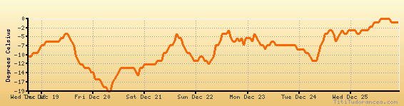
Temperature variation graph for the last seven days
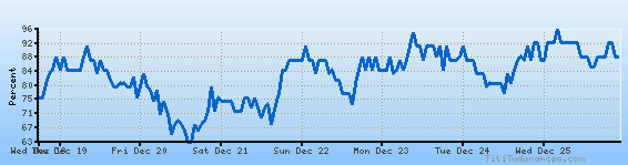
Humidity Variation Graph
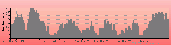
Wind speed
Weather Station: Sisseton, Sisseton Municipal Airport (latitude 45-40-08N, longitude 096-59-29W)
Local Time:
Sisseton is in the "America/Chicago" timezone.
The "America/Chicago" timezone uses a Standard Time (ST) / Daylight Saving Time (DST) alternation scheme, and it currently is in DST (since Sunday, 9 March 2025, 03:00 AM local time). During DST, the timezone abbreviation is CDT and the offset to Universal Time (UTC, GMT or Zulu) is -5:00 hours.
Sisseton will exit DST (returning to standard time) on Sunday, 2 November 2025, at 02:00 AM local time, when clocks will be turned backward 1 hour to Sunday, 2 November 2025, 01:00 AM local standard time. During ST, the timezone abbreviation is CST and the offset to UTC will be -6:00 hours.
Weather and Temperature in South Dakota
Popular Weather Searches:
 If you own or manage a travel-related business such as a hotel, a bed-and-breakfast, a restaurant, a pub or a cafeteria, you can create a web page for your business for free on Titi Tudorancea Travel Info. » |