| Published in Weather / Wyoming Weather Temperature |
Weather in Sheridan City/County, Wyoming
Current Conditions (Sunday, February 16, 2025 at 20:13 America/Denver time)
Temperature: 9°F (-13°C) |
Forecast Overview
Mon Feb 17 
9°F -2°F -13°C -19°C Chance of light snow all day.
detailsTue Feb 18 3°F -13°F -16°C -25°C Chance of snow until 5 pm.
detailsWed Feb 19 
16°F -17°F -9°C -27°C Considerable cloudiness.
detailsThu Feb 20 23°F -8°F -5°C -22°C Partly cloudy skies.
detailsFri Feb 21 34°F 14°F 1°C -10°C Partly cloudy skies.
detailsSat Feb 22 
37°F 25°F 3°C -4°C Times of sun and clouds.
detailsSun Feb 23 39°F 23°F 4°C -5°C Times of sun and clouds.
detailsMon Feb 24 
46°F 34°F 8°C 1°C Chance of light rain before sunrise.
detailsTue Feb 25 45°F 32°F 7°C -0°C Times of sun and clouds.
details
Detailed Forecast
| Monday, February 17 | sunrise: 07:07 sunset: 17:37 |
| Low around -2°F (-19°C), high around 8°F (-13°C). Chance of light snow all day (from 2 am to 11 pm). Estimated precipitation: 0.16 in (3.9375 mm). Overcast skies. Wind: 6 mph (10 km/h). |
| Time | Skies | Conditions | Temp | Wind | Humidity | Soil Moisture |
| 23:00 02:00 | Overcast. Precipitation: 0.02 in (0.5 mm). | 3°F (-16°C) | 5 mph (8 km/h) | 96% | 0.439% | |
| 02:00 05:00 | Chance of light snow. Precipitation: 0.01 in (0.25 mm). | 2°F (-17°C) | 3 mph (5 km/h) | 96% | 0.439% | |
| 05:00 08:00 | Chance of light snow. Precipitation: 0.02 in (0.625 mm). | 2°F (-17°C) | 5 mph (9 km/h) | 96% | 0.439% | |
| 08:00 11:00 | Chance of light snow. Precipitation: 0.04 in (0.9375 mm). | 4°F (-16°C) | 5 mph (9 km/h) | 91% | 0.439% | |
| 11:00 14:00 | Chance of light snow. Precipitation: 0.01 in (0.25 mm). | 7°F (-14°C) | 6 mph (10 km/h) | 85% | 0.439% | |
| 14:00 17:00 | Chance of light snow. Precipitation: 0.01 in (0.25 mm). | 7°F (-14°C) | 5 mph (9 km/h) | 95% | 0.439% | |
| 17:00 20:00 | Chance of light snow. Precipitation: 0.03 in (0.6875 mm). | 1°F (-17°C) | 3 mph (6 km/h) | 97% | 0.439% | |
| 20:00 23:00 | Chance of light snow. Precipitation: 0.02 in (0.4375 mm). | -1°F (-18°C) | 4 mph (6 km/h) | 98% | 0.439% |
| Tuesday, February 18 | sunrise: 07:05 sunset: 17:38 |
| Low around -13°F (-25°C), high around 3°F (-16°C). Chance of snow until 5 pm. Estimated precipitation: 0.1 in (2.625 mm). Overcast skies. Wind: 6 mph (9 km/h). |
| Time | Skies | Conditions | Temp | Wind | Humidity | Soil Moisture |
| 23:00 02:00 | Chance of snow. Precipitation: 0.04 in (1.125 mm). | -3°F (-19°C) | 3 mph (5 km/h) | 98% | 0.439% | |
| 02:00 05:00 | Chance of light snow. Precipitation: 0.01 in (0.375 mm). | -3°F (-20°C) | 2 mph (3 km/h) | 98% | 0.439% | |
| 05:00 08:00 | Chance of light snow. Precipitation: 0.01 in (0.375 mm). | -3°F (-20°C) | 3 mph (4 km/h) | 97% | 0.439% | |
| 08:00 11:00 | Chance of light snow. Precipitation: 0.01 in (0.3125 mm). | 0°F (-18°C) | 5 mph (9 km/h) | 91% | 0.439% | |
| 11:00 14:00 | Chance of light snow. Precipitation: 0.01 in (0.25 mm). | 3°F (-16°C) | 6 mph (9 km/h) | 85% | 0.439% | |
| 14:00 17:00 | Chance of light snow. Precipitation: 0 in (0.0625 mm). | -2°F (-19°C) | 5 mph (8 km/h) | 94% | 0.439% | |
| 17:00 20:00 | Mostly cloudy. Precipitation: 0 in (0.0625 mm). | -11°F (-24°C) | 4 mph (6 km/h) | 94% | 0.439% | |
| 20:00 23:00 | Mostly cloudy. Precipitation: 0 in (0.0625 mm). | -13°F (-25°C) | 3 mph (4 km/h) | 95% | 0.439% |
| Wednesday, February 19 | sunrise: 07:04 sunset: 17:40 |
| Low around -17°F (-27°C), high around 15°F (-9°C). Estimated precipitation: 0 in (0.0625 mm). Considerable cloudiness. Wind: 7 mph (11 km/h). |
| Time | Skies | Conditions | Temp | Wind | Humidity | Soil Moisture |
| 23:00 02:00 | Partly cloudy. | -15°F (-26°C) | 3 mph (5 km/h) | 92% | 0.439% | |
| 02:00 05:00 | Clear. | -16°F (-26°C) | 2 mph (3 km/h) | 91% | 0.439% | |
| 05:00 08:00 | A few passing clouds. | -13°F (-25°C) | 1 mph (1 km/h) | 95% | 0.439% | |
| 08:00 11:00 | More sun than clouds. | 3°F (-16°C) | 4 mph (7 km/h) | 88% | 0.439% | |
| 11:00 14:00 | Partly cloudy. | 14°F (-10°C) | 7 mph (11 km/h) | 81% | 0.439% | |
| 14:00 17:00 | Overcast. Precipitation: 0 in (0.0625 mm). | 10°F (-12°C) | 6 mph (10 km/h) | 89% | 0.439% | |
| 17:00 20:00 | Overcast. | 0°F (-18°C) | 1 mph (2 km/h) | 94% | 0.439% | |
| 20:00 23:00 | Overcast. | -1°F (-18°C) | 1 mph (1 km/h) | 95% | 0.439% |
| Thursday, February 20 | sunrise: 07:02 sunset: 17:41 |
| Low around -7°F (-22°C), high around 22°F (-5°C). Partly cloudy skies. Wind: 5 mph (8 km/h). |
| Time | Skies | Conditions | Temp | Wind | Humidity | Soil Moisture |
| 23:00 02:00 | Overcast. | -5°F (-20°C) | 1 mph (1 km/h) | 96% | 0.439% | |
| 02:00 05:00 | Clear. | -7°F (-22°C) | 1 mph (2 km/h) | 95% | 0.439% | |
| 05:00 08:00 | Overcast. | -0°F (-18°C) | 1 mph (1 km/h) | 96% | 0.439% | |
| 08:00 11:00 | Mostly sunny, with a few passing clouds. | 13°F (-11°C) | 5 mph (8 km/h) | 87% | 0.439% | |
| 11:00 14:00 | A few passing clouds. | 20°F (-7°C) | 3 mph (4 km/h) | 84% | 0.439% | |
| 14:00 17:00 | More sun than clouds. | 18°F (-8°C) | 2 mph (3 km/h) | 92% | 0.439% | |
| 17:00 20:00 | Mostly clear, with a few passing clouds. | 13°F (-11°C) | 4 mph (7 km/h) | 86% | 0.439% | |
| 20:00 23:00 | Overcast. | 14°F (-10°C) | 4 mph (7 km/h) | 81% | 0.439% |
| Friday, February 21 | sunrise: 07:00 sunset: 17:43 |
| Low around 15°F (-10°C), high around 34°F (1°C). Partly cloudy skies. Wind: 6 mph (9 km/h). |
| Time | Skies | Conditions | Temp | Wind | Humidity | Soil Moisture |
| 23:00 02:00 | Clear. | 16°F (-9°C) | 5 mph (8 km/h) | 79% | 0.439% | |
| 02:00 05:00 | Overcast. | 16°F (-9°C) | 5 mph (7 km/h) | 79% | 0.439% | |
| 05:00 08:00 | More sun than clouds. | 22°F (-6°C) | 4 mph (7 km/h) | 78% | 0.439% | |
| 08:00 11:00 | Mostly cloudy. | 33°F (1°C) | 1 mph (2 km/h) | 97% | 0.439% | |
| 11:00 14:00 | Overcast. | 33°F (1°C) | 3 mph (6 km/h) | 100% | 0.439% | |
| 14:00 17:00 | Sunny. | 33°F (0°C) | 4 mph (7 km/h) | 95% | 0.439% | |
| 17:00 20:00 | A few passing clouds. | 27°F (-3°C) | 4 mph (7 km/h) | 80% | 0.439% | |
| 20:00 23:00 | Clear. | 26°F (-3°C) | 6 mph (9 km/h) | 72% | 0.439% |
| Saturday, February 22 | sunrise: 06:59 sunset: 17:44 |
| Low around 24°F (-4°C), high around 38°F (3°C). Estimated precipitation: 0 in (0.0625 mm). Times of sun and clouds. Wind: 7 mph (11 km/h). |
| Time | Skies | Conditions | Temp | Wind | Humidity | Soil Moisture |
| 23:00 02:00 | Clear. | 27°F (-3°C) | 6 mph (9 km/h) | 69% | 0.439% | |
| 02:00 05:00 | Clear. | 25°F (-4°C) | 5 mph (9 km/h) | 72% | 0.439% | |
| 05:00 08:00 | Sunny. | 30°F (-1°C) | 5 mph (8 km/h) | 71% | 0.439% | |
| 08:00 11:00 | Overcast. | 34°F (1°C) | 5 mph (8 km/h) | 100% | 0.439% | |
| 11:00 14:00 | Overcast. Precipitation: 0 in (0.0625 mm). | 36°F (2°C) | 7 mph (11 km/h) | 96% | 0.439% | |
| 14:00 17:00 | Sunny. | 32°F (0°C) | 1 mph (2 km/h) | 87% | 0.439% | |
| 17:00 20:00 | Clear. | 26°F (-3°C) | 7 mph (11 km/h) | 75% | 0.439% | |
| 20:00 23:00 | Clear. | 25°F (-4°C) | 7 mph (11 km/h) | 72% | 0.439% |
| Sunday, February 23 | sunrise: 06:57 sunset: 17:45 |
| Low around 24°F (-5°C), high around 40°F (4°C). Times of sun and clouds. Wind: 8 mph (13 km/h). |
| Time | Skies | Conditions | Temp | Wind | Humidity | Soil Moisture |
| 23:00 02:00 | Clear. | 25°F (-4°C) | 8 mph (13 km/h) | 69% | 0.439% | |
| 02:00 05:00 | Clear. | 24°F (-5°C) | 8 mph (12 km/h) | 67% | 0.439% | |
| 05:00 08:00 | Overcast. | 29°F (-2°C) | 7 mph (12 km/h) | 64% | 0.439% | |
| 08:00 11:00 | Overcast. | 38°F (3°C) | 4 mph (6 km/h) | 99% | 0.439% | |
| 11:00 14:00 | Mostly cloudy. | 39°F (4°C) | 4 mph (7 km/h) | 99% | 0.439% | |
| 14:00 17:00 | Sunny. | 37°F (3°C) | 5 mph (8 km/h) | 83% | 0.439% | |
| 17:00 20:00 | Clear. | 34°F (1°C) | 7 mph (11 km/h) | 71% | 0.439% | |
| 20:00 23:00 | Clear. | 35°F (2°C) | 7 mph (11 km/h) | 71% | 0.439% |
| Monday, February 24 | sunrise: 06:56 sunset: 17:47 |
| Low around 33°F (1°C), high around 46°F (8°C). Chance of light rain before sunrise (between 2 am and 5 am). Estimated precipitation: 0.01 in (0.375 mm). More clouds than sun. Wind: 7 mph (11 km/h). |
| Time | Skies | Conditions | Temp | Wind | Humidity | Soil Moisture |
| 23:00 02:00 | Times of clear skies and clouds. | 34°F (1°C) | 6 mph (10 km/h) | 74% | 0.439% | |
| 02:00 05:00 | Chance of light rain. Precipitation: 0 in (0.125 mm). | 36°F (2°C) | 6 mph (10 km/h) | 83% | 0.439% | |
| 05:00 08:00 | Mostly cloudy. Precipitation: 0.01 in (0.25 mm). | 38°F (3°C) | 7 mph (11 km/h) | 84% | 0.439% | |
| 08:00 11:00 | Sunny. | 42°F (6°C) | 2 mph (3 km/h) | 98% | 0.439% | |
| 11:00 14:00 | Mostly sunny, with a few passing clouds. | 45°F (7°C) | 3 mph (5 km/h) | 89% | 0.439% | |
| 14:00 17:00 | Mostly sunny, with a few passing clouds. | 42°F (6°C) | 5 mph (8 km/h) | 79% | 0.439% | |
| 17:00 20:00 | Overcast. | 39°F (4°C) | 7 mph (11 km/h) | 68% | 0.439% | |
| 20:00 23:00 | Clear. | 39°F (4°C) | 7 mph (11 km/h) | 66% | 0.438% |
| Tuesday, February 25 | sunrise: 06:54 sunset: 17:48 |
| Low around 32°F (-0°C), high around 45°F (7°C). Times of sun and clouds. Wind: 20 mph (32 km/h). |
| Time | Skies | Conditions | Temp | Wind | Humidity | Soil Moisture |
| 23:00 02:00 | Considerable cloudiness. | 40°F (4°C) | 6 mph (10 km/h) | 66% | 0.438% | |
| 02:00 05:00 | Clear. | 38°F (4°C) | 5 mph (8 km/h) | 68% | 0.438% | |
| 05:00 08:00 | Considerable cloudiness. | 42°F (5°C) | 6 mph (9 km/h) | 65% | 0.438% | |
| 08:00 11:00 | Sunny. | 42°F (5°C) | 10 mph (17 km/h) | 75% | 0.438% | |
| 11:00 14:00 | Overcast. | 38°F (4°C) | 10 mph (16 km/h) | 70% | 0.437% | |
| 14:00 17:00 | Sunny. | 39°F (4°C) | 10 mph (16 km/h) | 68% | 0.434% | |
| 17:00 20:00 | Clear. | 36°F (2°C) | 20 mph (32 km/h) | 46% | 0.431% | |
| 20:00 23:00 | Clear. | 32°F (-0°C) | 11 mph (17 km/h) | 60% | 0.428% |
Climate Chart
» Sheridan City/County Climate Chart
Places with a similar climate: Casper, Natrona County (WY), Gillette, Campbell County (WY), Douglas, Converse County (WY), Bozeman, Gallatin Field (MT), Rapid City (SD), Great Falls (MT), Challis (ID), Lander (WY), Cody (WY), Riverton (WY), Helena (MT), Salmon, Lemhi County (ID), Alliance (NE), Lewistown (MT).
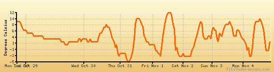
Temperature variation graph for the last seven days
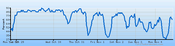
Humidity Variation Graph
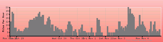
Wind speed
Weather Station: Sheridan, Sheridan County Airport (latitude 44-46-10N, longitude 106-58-08W)
Local Time:
Sheridan City/County is in the "America/Denver" timezone.
The "America/Denver" timezone uses a Standard Time (ST) / Daylight Saving Time (DST) alternation scheme, and it currently is in ST (since Sunday, 3 November 2024, 01:00 AM local time). During ST, the timezone abbreviation is MST and the offset to Universal Time (UTC, GMT or Zulu) is -7:00 hours.
Sheridan City/County will exit standard time (entering DST) on Sunday, 9 March 2025, at 02:00 AM local time, when clocks will be turned forward 1 hour to Sunday, 9 March 2025, 03:00 AM local daylight time. During DST, the timezone abbreviation is MDT and the offset to UTC will be -6:00 hours.
Weather and Temperature in Wyoming
Popular Weather Searches:
 If you own or manage a travel-related business such as a hotel, a bed-and-breakfast, a restaurant, a pub or a cafeteria, you can create a web page for your business for free on Titi Tudorancea Travel Info. » |