| Published in Weather / Finland Weather Temperature |
Weather in Savonlinna, Finland
Current Conditions (Thursday, February 20, 2025 at 03:50 Europe/Helsinki time)
Temperature: 12°F (-11°C) |
Forecast Overview
Thu Feb 20 
25°F 14°F -4°C -10°C Considerable cloudiness.
detailsFri Feb 21 
28°F 21°F -2°C -6°C Chance of snow after 2 pm.
detailsSat Feb 22 
32°F 27°F -0°C -3°C Chance of light snow in the morning. Chance of light, freezing rain after 5 pm.
detailsSun Feb 23 
32°F 23°F 0°C -5°C More sun than clouds.
detailsMon Feb 24 
30°F 23°F -1°C -5°C Overcast skies.
detailsTue Feb 25 
32°F 25°F 0°C -4°C Chance of light snow in the afternoon and in the evening.
detailsWed Feb 26 
34°F 30°F 1°C -1°C Chance of snow before sunrise and late at night.
detailsThu Feb 27 
34°F 28°F 1°C -2°C Chance of light snow at various times.
detailsFri Feb 28 
30°F 12°F -1°C -11°C Chance of light snow before sunrise and in the evening.
details
Detailed Forecast
| Thursday, February 20 | sunrise: 07:39 sunset: 16:58 |
| Low around 15°F (-10°C), high around 26°F (-4°C). Considerable cloudiness. Wind: 10 mph (17 km/h). |
| Time | Skies | Conditions | Temp | Wind | Humidity | Soil Moisture |
| 23:00 02:00 | Partly cloudy. | 16°F (-9°C) | 6 mph (9 km/h) | 91% | 0.434% | |
| 02:00 05:00 | Overcast. | 17°F (-8°C) | 6 mph (10 km/h) | 86% | 0.434% | |
| 05:00 08:00 | Sunny. | 15°F (-9°C) | 6 mph (10 km/h) | 89% | 0.434% | |
| 08:00 11:00 | Sunny. | 22°F (-6°C) | 8 mph (13 km/h) | 81% | 0.434% | |
| 11:00 14:00 | Partly cloudy. | 26°F (-4°C) | 9 mph (14 km/h) | 81% | 0.434% | |
| 14:00 17:00 | Clear. | 22°F (-6°C) | 8 mph (13 km/h) | 88% | 0.434% | |
| 17:00 20:00 | Overcast. | 21°F (-6°C) | 9 mph (15 km/h) | 94% | 0.434% | |
| 20:00 23:00 | Overcast. | 23°F (-5°C) | 10 mph (17 km/h) | 93% | 0.434% |
| Friday, February 21 | sunrise: 07:36 sunset: 17:01 |
| Low around 21°F (-6°C), high around 29°F (-2°C). Chance of snow after 2 pm. Estimated precipitation: 0.1 in (2.4375 mm). Overcast skies. Wind: 16 mph (25 km/h). |
| Time | Skies | Conditions | Temp | Wind | Humidity | Soil Moisture |
| 23:00 02:00 | Overcast. | 24°F (-4°C) | 10 mph (16 km/h) | 90% | 0.434% | |
| 02:00 05:00 | Overcast. | 25°F (-4°C) | 11 mph (17 km/h) | 93% | 0.434% | |
| 05:00 08:00 | Overcast. | 26°F (-3°C) | 12 mph (20 km/h) | 92% | 0.434% | |
| 08:00 11:00 | Overcast. Precipitation: 0 in (0.0625 mm). | 29°F (-2°C) | 13 mph (22 km/h) | 82% | 0.434% | |
| 11:00 14:00 | Overcast. | 28°F (-2°C) | 14 mph (22 km/h) | 83% | 0.434% | |
| 14:00 17:00 | Chance of light snow. Precipitation: 0 in (0.0625 mm). | 26°F (-3°C) | 14 mph (23 km/h) | 88% | 0.434% | |
| 17:00 20:00 | Chance of light snow. Precipitation: 0.04 in (0.9375 mm). | 26°F (-3°C) | 16 mph (25 km/h) | 92% | 0.434% | |
| 20:00 23:00 | Chance of snow. Precipitation: 0.05 in (1.375 mm). | 27°F (-3°C) | 14 mph (23 km/h) | 95% | 0.434% |
| Saturday, February 22 | sunrise: 07:33 sunset: 17:04 |
| Low around 26°F (-3°C), high around 31°F (-0°C). Chance of light snow in the morning (before 2 am and from 5 am to 11 am). Chance of light, freezing rain in the evening and during the night (after 5 pm). Estimated precipitation: 0.05 in (1.3125 mm). Overcast skies. Wind: 14 mph (23 km/h). |
| Time | Skies | Conditions | Temp | Wind | Humidity | Soil Moisture |
| 23:00 02:00 | Chance of light snow. Precipitation: 0.02 in (0.5625 mm). | 28°F (-2°C) | 14 mph (23 km/h) | 94% | 0.434% | |
| 02:00 05:00 | Overcast. Precipitation: 0 in (0.0625 mm). | 29°F (-2°C) | 13 mph (20 km/h) | 95% | 0.434% | |
| 05:00 08:00 | Chance of light snow. Precipitation: 0 in (0.125 mm). | 29°F (-2°C) | 11 mph (18 km/h) | 95% | 0.434% | |
| 08:00 11:00 | Chance of light snow. Precipitation: 0 in (0.0625 mm). | 30°F (-1°C) | 11 mph (17 km/h) | 94% | 0.434% | |
| 11:00 14:00 | Overcast. Precipitation: 0 in (0.0625 mm). | 31°F (-0°C) | 12 mph (19 km/h) | 93% | 0.434% | |
| 14:00 17:00 | Overcast. | 30°F (-1°C) | 13 mph (20 km/h) | 94% | 0.434% | |
| 17:00 20:00 | Possibly freezing rain leading to formation of glaze ice. Precipitation: 0.01 in (0.1875 mm). | 29°F (-2°C) | 12 mph (19 km/h) | 94% | 0.434% | |
| 20:00 23:00 | Possibly freezing rain leading to formation of glaze ice. Precipitation: 0.01 in (0.25 mm). | 29°F (-2°C) | 11 mph (17 km/h) | 94% | 0.434% |
| Sunday, February 23 | sunrise: 07:30 sunset: 17:06 |
| Low around 24°F (-5°C), high around 32°F (0°C). Estimated precipitation: 0 in (0.0625 mm). More sun than clouds. Wind: 11 mph (18 km/h). |
| Time | Skies | Conditions | Temp | Wind | Humidity | Soil Moisture |
| 23:00 02:00 | Partly cloudy. Precipitation: 0 in (0.0625 mm). | 29°F (-2°C) | 10 mph (17 km/h) | 93% | 0.434% | |
| 02:00 05:00 | Overcast. | 29°F (-2°C) | 10 mph (16 km/h) | 92% | 0.434% | |
| 05:00 08:00 | Overcast. | 30°F (-1°C) | 10 mph (17 km/h) | 90% | 0.434% | |
| 08:00 11:00 | Overcast. | 31°F (-0°C) | 11 mph (17 km/h) | 86% | 0.434% | |
| 11:00 14:00 | Sunny. | 32°F (0°C) | 11 mph (18 km/h) | 83% | 0.434% | |
| 14:00 17:00 | Sunny. | 28°F (-2°C) | 11 mph (18 km/h) | 84% | 0.434% | |
| 17:00 20:00 | Clear. | 25°F (-4°C) | 11 mph (17 km/h) | 88% | 0.434% | |
| 20:00 23:00 | Clear. | 24°F (-5°C) | 9 mph (15 km/h) | 90% | 0.434% |
| Monday, February 24 | sunrise: 07:27 sunset: 17:09 |
| Low around 23°F (-5°C), high around 30°F (-1°C). Estimated precipitation: 0.01 in (0.25 mm). Overcast skies. Wind: 11 mph (17 km/h). |
| Time | Skies | Conditions | Temp | Wind | Humidity | Soil Moisture |
| 23:00 02:00 | Overcast. | 24°F (-5°C) | 9 mph (14 km/h) | 91% | 0.434% | |
| 02:00 05:00 | Overcast. | 25°F (-4°C) | 9 mph (14 km/h) | 92% | 0.434% | |
| 05:00 08:00 | Overcast. Precipitation: 0 in (0.125 mm). | 27°F (-3°C) | 9 mph (14 km/h) | 94% | 0.434% | |
| 08:00 11:00 | Overcast. | 29°F (-2°C) | 10 mph (16 km/h) | 94% | 0.434% | |
| 11:00 14:00 | Overcast. Precipitation: 0 in (0.0625 mm). | 30°F (-1°C) | 10 mph (15 km/h) | 94% | 0.434% | |
| 14:00 17:00 | Overcast. | 30°F (-1°C) | 10 mph (16 km/h) | 94% | 0.434% | |
| 17:00 20:00 | Overcast. Precipitation: 0 in (0.0625 mm). | 29°F (-2°C) | 11 mph (17 km/h) | 94% | 0.434% | |
| 20:00 23:00 | Mostly cloudy. | 30°F (-1°C) | 10 mph (17 km/h) | 93% | 0.434% |
| Tuesday, February 25 | sunrise: 07:24 sunset: 17:12 |
| Low around 26°F (-4°C), high around 32°F (0°C). Chance of light snow late in the afternoon and in the evening (between 2 pm and 8 pm). Estimated precipitation: 0.01 in (0.3125 mm). Overcast skies. Wind: 12 mph (19 km/h). |
| Time | Skies | Conditions | Temp | Wind | Humidity | Soil Moisture |
| 23:00 02:00 | Overcast. | 29°F (-2°C) | 10 mph (15 km/h) | 92% | 0.434% | |
| 02:00 05:00 | Overcast. | 28°F (-2°C) | 10 mph (16 km/h) | 90% | 0.434% | |
| 05:00 08:00 | Overcast. | 26°F (-3°C) | 10 mph (16 km/h) | 93% | 0.434% | |
| 08:00 11:00 | Overcast. | 32°F (-0°C) | 11 mph (17 km/h) | 90% | 0.434% | |
| 11:00 14:00 | Overcast. | 31°F (-0°C) | 11 mph (18 km/h) | 91% | 0.434% | |
| 14:00 17:00 | Chance of light snow. Precipitation: 0 in (0.125 mm). | 30°F (-1°C) | 12 mph (19 km/h) | 95% | 0.434% | |
| 17:00 20:00 | Chance of light snow. Precipitation: 0 in (0.125 mm). | 31°F (-0°C) | 11 mph (18 km/h) | 95% | 0.434% | |
| 20:00 23:00 | Overcast. Precipitation: 0 in (0.0625 mm). | 32°F (-0°C) | 9 mph (15 km/h) | 96% | 0.434% |
| Wednesday, February 26 | sunrise: 07:20 sunset: 17:15 |
| Low around 30°F (-1°C), high around 34°F (1°C). Chance of snow between 11 pm and 2 am and again at night (after 8 pm). Estimated precipitation: 0.09 in (2.25 mm). Mostly cloudy skies. Wind: 9 mph (14 km/h). |
| Time | Skies | Conditions | Temp | Wind | Humidity | Soil Moisture |
| 23:00 02:00 | Chance of light snow. Precipitation: 0 in (0.125 mm). | 32°F (-0°C) | 8 mph (13 km/h) | 94% | 0.434% | |
| 02:00 05:00 | Overcast. Precipitation: 0 in (0.125 mm). | 32°F (0°C) | 8 mph (13 km/h) | 95% | 0.434% | |
| 05:00 08:00 | Sunny. | 30°F (-1°C) | 7 mph (12 km/h) | 96% | 0.434% | |
| 08:00 11:00 | More sun than clouds. | 34°F (1°C) | 6 mph (10 km/h) | 97% | 0.434% | |
| 11:00 14:00 | Overcast. | 32°F (0°C) | 9 mph (14 km/h) | 95% | 0.434% | |
| 14:00 17:00 | Overcast. | 32°F (-0°C) | 6 mph (10 km/h) | 93% | 0.434% | |
| 17:00 20:00 | Overcast. | 32°F (-0°C) | 8 mph (13 km/h) | 93% | 0.434% | |
| 20:00 23:00 | Chance of snow. Precipitation: 0.08 in (2 mm). | 32°F (-0°C) | 7 mph (12 km/h) | 99% | 0.434% |
| Thursday, February 27 | sunrise: 07:17 sunset: 17:18 |
| Low around 29°F (-2°C), high around 33°F (1°C). Chance of light snow in the morning from 11 pm to 2 am and from 8 am to 11 am, late in the afternoon (between 2 pm and 5 pm) and again at night (after 8 pm). Estimated precipitation: 0.06 in (1.625 mm). Overcast skies. Wind: 6 mph (10 km/h). |
| Time | Skies | Conditions | Temp | Wind | Humidity | Soil Moisture |
| 23:00 02:00 | Chance of light snow. Precipitation: 0.02 in (0.5 mm). | 29°F (-2°C) | 6 mph (10 km/h) | 98% | 0.434% | |
| 02:00 05:00 | Overcast. Precipitation: 0.01 in (0.1875 mm). | 31°F (-0°C) | 5 mph (8 km/h) | 98% | 0.433% | |
| 05:00 08:00 | Overcast. Precipitation: 0 in (0.0625 mm). | 32°F (-0°C) | 5 mph (8 km/h) | 96% | 0.433% | |
| 08:00 11:00 | Chance of light snow. Precipitation: 0 in (0.125 mm). | 33°F (0°C) | 5 mph (8 km/h) | 99% | 0.434% | |
| 11:00 14:00 | Overcast. Precipitation: 0.01 in (0.375 mm). | 33°F (0°C) | 2 mph (3 km/h) | 100% | 0.434% | |
| 14:00 17:00 | Chance of light snow. Precipitation: 0 in (0.125 mm). | 32°F (0°C) | 2 mph (4 km/h) | 99% | 0.434% | |
| 17:00 20:00 | Mostly cloudy. Precipitation: 0.01 in (0.1875 mm). | 30°F (-1°C) | 2 mph (4 km/h) | 99% | 0.434% | |
| 20:00 23:00 | Chance of light snow. Precipitation: 0 in (0.0625 mm). | 31°F (-1°C) | 3 mph (5 km/h) | 99% | 0.434% |
| Friday, February 28 | sunrise: 07:14 sunset: 17:20 |
| Low around 12°F (-11°C), high around 31°F (-1°C). Chance of light snow between 11 pm and 2 am and again in the evening (between 5 pm and 8 pm). Estimated precipitation: 0.02 in (0.5625 mm). Overcast skies. Wind: 8 mph (13 km/h). |
| Time | Skies | Conditions | Temp | Wind | Humidity | Soil Moisture |
| 23:00 02:00 | Chance of light snow. Precipitation: 0.01 in (0.1875 mm). | 29°F (-2°C) | 5 mph (8 km/h) | 98% | 0.433% | |
| 02:00 05:00 | Overcast. Precipitation: 0 in (0.125 mm). | 28°F (-2°C) | 7 mph (11 km/h) | 94% | 0.433% | |
| 05:00 08:00 | Overcast. Precipitation: 0 in (0.0625 mm). | 29°F (-2°C) | 6 mph (9 km/h) | 92% | 0.433% | |
| 08:00 11:00 | Overcast. Precipitation: 0 in (0.0625 mm). | 29°F (-2°C) | 7 mph (11 km/h) | 90% | 0.433% | |
| 11:00 14:00 | Overcast. | 29°F (-2°C) | 8 mph (12 km/h) | 85% | 0.433% | |
| 14:00 17:00 | Overcast. Precipitation: 0 in (0.0625 mm). | 25°F (-4°C) | 7 mph (12 km/h) | 90% | 0.433% | |
| 17:00 20:00 | Chance of light snow. Precipitation: 0 in (0.0625 mm). | 20°F (-7°C) | 8 mph (13 km/h) | 91% | 0.433% | |
| 20:00 23:00 | Partly cloudy. | 12°F (-11°C) | 7 mph (12 km/h) | 92% | 0.434% |
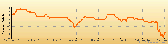
Temperature variation graph for the last seven days
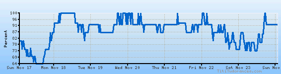
Humidity Variation Graph
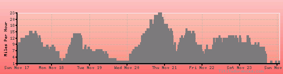
Wind speed
Weather Station: Savonlinna (latitude 61-57N, longitude 028-57E)
Local Time:
Savonlinna is in the "Europe/Helsinki" timezone.
The "Europe/Helsinki" timezone uses a Standard Time (ST) / Daylight Saving Time (DST) alternation scheme, and it currently is in ST (since Sunday, 27 October 2024, 03:00 AM local time). During ST, the timezone abbreviation is EET and the offset to Universal Time (UTC, GMT or Zulu) is +2:00 hours.
Savonlinna will exit standard time (entering DST) on Sunday, 30 March 2025, at 03:00 AM local time, when clocks will be turned forward 1 hour to Sunday, 30 March 2025, 04:00 AM local daylight time. During DST, the timezone abbreviation is EEST and the offset to UTC will be +3:00 hours.
Weather and Temperature in Finland
Popular Weather Searches:
 If you own or manage a travel-related business such as a hotel, a bed-and-breakfast, a restaurant, a pub or a cafeteria, you can create a web page for your business for free on Titi Tudorancea Travel Info. » |