| Published in Weather / North Carolina Weather Temperature |
Weather in Sanford, Lee County, North Carolina
Current Conditions (Friday, March 14, 2025 at 14:50 America/New_York time)
Temperature: 59°F (15°C) |
Forecast Overview
Sat Mar 15 
77°F 52°F 25°C 11°C Partly cloudy skies.
detailsSun Mar 16 
75°F 59°F 24°C 15°C Chance of heavy rain in the afternoon.
detailsMon Mar 17 61°F 46°F 16°C 8°C Partly cloudy skies.
detailsTue Mar 18 
68°F 39°F 20°C 4°C Sunny skies.
detailsWed Mar 19 
72°F 46°F 22°C 8°C Mostly cloudy skies.
detailsThu Mar 20 61°F 41°F 16°C 5°C More clouds than sun.
detailsFri Mar 21 
59°F 39°F 15°C 4°C Mostly sunny, with a few passing clouds.
detailsSat Mar 22 
63°F 45°F 17°C 7°C Chance of light rain after 5 pm.
detailsSun Mar 23 59°F 41°F 15°C 5°C Mostly sunny.
details
Detailed Forecast
| Friday, March 14 | sunrise: 07:30 sunset: 19:22 |
| Mostly cloudy skies. Wind: 7 mph (12 km/h). |
| Time | Skies | Conditions | Temp | Wind | Humidity | Soil Moisture |
| 14:00 17:00 | Overcast. | 69°F (21°C) | 7 mph (12 km/h) | 48% | 0.179% | |
| 17:00 20:00 | Overcast. | 61°F (16°C) | 6 mph (10 km/h) | 67% | 0.179% | |
| 20:00 23:00 | Times of clear skies and clouds. | 57°F (14°C) | 7 mph (11 km/h) | 79% | 0.179% |
| Saturday, March 15 | sunrise: 07:28 sunset: 19:22 |
| Low around 51°F (11°C), high around 78°F (25°C). Estimated precipitation: 0 in (0.0625 mm). Partly cloudy skies. Wind: 16 mph (26 km/h). |
| Time | Skies | Conditions | Temp | Wind | Humidity | Soil Moisture |
| 23:00 02:00 | Clear. | 53°F (12°C) | 6 mph (9 km/h) | 97% | 0.179% | |
| 02:00 05:00 | Partly cloudy. | 52°F (11°C) | 6 mph (9 km/h) | 99% | 0.18% | |
| 05:00 08:00 | Times of sun and clouds. | 52°F (11°C) | 5 mph (9 km/h) | 98% | 0.181% | |
| 08:00 11:00 | Times of sun and clouds. | 67°F (20°C) | 11 mph (18 km/h) | 69% | 0.181% | |
| 11:00 14:00 | Overcast. Precipitation: 0 in (0.0625 mm). | 76°F (25°C) | 14 mph (23 km/h) | 46% | 0.178% | |
| 14:00 17:00 | Overcast. | 76°F (24°C) | 15 mph (24 km/h) | 46% | 0.176% | |
| 17:00 20:00 | Partly cloudy. | 67°F (19°C) | 16 mph (26 km/h) | 73% | 0.175% | |
| 20:00 23:00 | Overcast. | 65°F (18°C) | 16 mph (25 km/h) | 82% | 0.175% |
| Sunday, March 16 | sunrise: 07:27 sunset: 19:23 |
| Low around 58°F (15°C), high around 75°F (24°C). Chance of heavy rain during the afternoon (between 11 am and 5 pm). Estimated precipitation: 1.31 in (33.375 mm). Overcast skies. Wind: 28 mph (45 km/h). |
| Time | Skies | Conditions | Temp | Wind | Humidity | Soil Moisture |
| 23:00 02:00 | Overcast. | 65°F (18°C) | 18 mph (29 km/h) | 82% | 0.175% | |
| 02:00 05:00 | Overcast. | 67°F (19°C) | 19 mph (31 km/h) | 81% | 0.175% | |
| 05:00 08:00 | Overcast. Precipitation: 0 in (0.0625 mm). | 68°F (20°C) | 21 mph (33 km/h) | 81% | 0.175% | |
| 08:00 11:00 | Overcast. Precipitation: 0 in (0.0625 mm). | 70°F (21°C) | 23 mph (38 km/h) | 77% | 0.175% | |
| 11:00 14:00 | Chance of rain. Precipitation: 0.1 in (2.625 mm). | 73°F (23°C) | 28 mph (45 km/h) | 76% | 0.189% | |
| 14:00 17:00 | Chance of heavy rain. Precipitation: 1.2 in (30.375 mm). | 61°F (16°C) | 16 mph (26 km/h) | 87% | 0.327% | |
| 17:00 20:00 | Overcast. Precipitation: 0.01 in (0.25 mm). | 61°F (16°C) | 8 mph (12 km/h) | 92% | 0.291% | |
| 20:00 23:00 | Overcast. | 58°F (15°C) | 5 mph (8 km/h) | 97% | 0.28% |
| Monday, March 17 | sunrise: 07:26 sunset: 19:24 |
| Low around 47°F (8°C), high around 61°F (16°C). Partly cloudy skies. Wind: 15 mph (24 km/h). |
| Time | Skies | Conditions | Temp | Wind | Humidity | Soil Moisture |
| 23:00 02:00 | Clear. | 56°F (13°C) | 5 mph (8 km/h) | 94% | 0.273% | |
| 02:00 05:00 | Times of clear skies and clouds. | 52°F (11°C) | 7 mph (12 km/h) | 91% | 0.268% | |
| 05:00 08:00 | Overcast. | 52°F (11°C) | 12 mph (19 km/h) | 88% | 0.265% | |
| 08:00 11:00 | Considerable cloudiness. | 54°F (12°C) | 15 mph (24 km/h) | 67% | 0.26% | |
| 11:00 14:00 | Overcast. | 56°F (13°C) | 14 mph (22 km/h) | 55% | 0.254% | |
| 14:00 17:00 | Overcast. | 58°F (15°C) | 11 mph (18 km/h) | 53% | 0.251% | |
| 17:00 20:00 | Clear. | 51°F (11°C) | 7 mph (12 km/h) | 62% | 0.249% | |
| 20:00 23:00 | Clear. | 47°F (8°C) | 9 mph (15 km/h) | 59% | 0.248% |
| Tuesday, March 18 | sunrise: 07:24 sunset: 19:25 |
| Low around 39°F (4°C), high around 67°F (20°C). Sunny skies. Wind: 7 mph (11 km/h). |
| Time | Skies | Conditions | Temp | Wind | Humidity | Soil Moisture |
| 23:00 02:00 | Clear. | 42°F (6°C) | 7 mph (11 km/h) | 73% | 0.246% | |
| 02:00 05:00 | Clear. | 39°F (4°C) | 6 mph (10 km/h) | 76% | 0.246% | |
| 05:00 08:00 | Sunny. | 40°F (4°C) | 4 mph (6 km/h) | 69% | 0.245% | |
| 08:00 11:00 | Sunny. | 56°F (13°C) | 2 mph (4 km/h) | 41% | 0.243% | |
| 11:00 14:00 | Sunny. | 66°F (19°C) | 1 mph (2 km/h) | 29% | 0.239% | |
| 14:00 17:00 | Sunny. | 67°F (19°C) | 4 mph (6 km/h) | 29% | 0.235% | |
| 17:00 20:00 | Clear. | 57°F (14°C) | 3 mph (5 km/h) | 43% | 0.235% | |
| 20:00 23:00 | Clear. | 53°F (12°C) | 3 mph (5 km/h) | 48% | 0.234% |
| Wednesday, March 19 | sunrise: 07:23 sunset: 19:26 |
| Low around 47°F (8°C), high around 72°F (22°C). Mostly cloudy skies. Wind: 10 mph (16 km/h). |
| Time | Skies | Conditions | Temp | Wind | Humidity | Soil Moisture |
| 23:00 02:00 | Clear. | 51°F (11°C) | 4 mph (6 km/h) | 55% | 0.234% | |
| 02:00 05:00 | Clear. | 49°F (9°C) | 4 mph (7 km/h) | 61% | 0.234% | |
| 05:00 08:00 | Overcast. | 49°F (9°C) | 2 mph (3 km/h) | 67% | 0.235% | |
| 08:00 11:00 | Sunny. | 61°F (16°C) | 4 mph (6 km/h) | 48% | 0.233% | |
| 11:00 14:00 | Overcast. | 71°F (21°C) | 7 mph (11 km/h) | 36% | 0.229% | |
| 14:00 17:00 | Overcast. | 72°F (22°C) | 10 mph (15 km/h) | 35% | 0.224% | |
| 17:00 20:00 | Overcast. | 61°F (16°C) | 8 mph (13 km/h) | 57% | 0.224% | |
| 20:00 23:00 | Overcast. | 60°F (15°C) | 10 mph (16 km/h) | 56% | 0.224% |
| Thursday, March 20 | sunrise: 07:21 sunset: 19:27 |
| Low around 41°F (5°C), high around 61°F (16°C). More clouds than sun. Wind: 18 mph (30 km/h). |
| Time | Skies | Conditions | Temp | Wind | Humidity | Soil Moisture |
| 23:00 02:00 | Overcast. | 58°F (15°C) | 12 mph (19 km/h) | 58% | 0.223% | |
| 02:00 05:00 | Partly cloudy. | 57°F (14°C) | 14 mph (22 km/h) | 51% | 0.222% | |
| 05:00 08:00 | Overcast. | 56°F (13°C) | 10 mph (16 km/h) | 65% | 0.221% | |
| 08:00 11:00 | Overcast. | 52°F (11°C) | 12 mph (19 km/h) | 70% | 0.221% | |
| 11:00 14:00 | More sun than clouds. | 51°F (11°C) | 13 mph (20 km/h) | 45% | 0.219% | |
| 14:00 17:00 | Mostly sunny. | 54°F (12°C) | 18 mph (30 km/h) | 37% | 0.215% | |
| 17:00 20:00 | Clear. | 46°F (8°C) | 12 mph (20 km/h) | 44% | 0.214% | |
| 20:00 23:00 | Clear. | 41°F (5°C) | 10 mph (16 km/h) | 52% | 0.214% |
| Friday, March 21 | sunrise: 07:20 sunset: 19:28 |
| Low around 40°F (4°C), high around 58°F (15°C). Mostly sunny, with a few passing clouds. Wind: 15 mph (25 km/h). |
| Time | Skies | Conditions | Temp | Wind | Humidity | Soil Moisture |
| 23:00 02:00 | Clear. | 40°F (4°C) | 10 mph (17 km/h) | 55% | 0.213% | |
| 02:00 05:00 | Clear. | 41°F (5°C) | 15 mph (24 km/h) | 52% | 0.213% | |
| 05:00 08:00 | Sunny. | 41°F (5°C) | 12 mph (19 km/h) | 60% | 0.212% | |
| 08:00 11:00 | Sunny. | 47°F (8°C) | 14 mph (23 km/h) | 35% | 0.211% | |
| 11:00 14:00 | Sunny. | 54°F (12°C) | 15 mph (25 km/h) | 27% | 0.207% | |
| 14:00 17:00 | Sunny. | 58°F (14°C) | 14 mph (23 km/h) | 31% | 0.204% | |
| 17:00 20:00 | Times of clear skies and clouds. | 50°F (10°C) | 5 mph (9 km/h) | 54% | 0.203% | |
| 20:00 23:00 | Overcast. | 46°F (8°C) | 4 mph (7 km/h) | 60% | 0.204% |
| Saturday, March 22 | sunrise: 07:19 sunset: 19:28 |
| Low around 45°F (7°C), high around 62°F (17°C). Chance of light rain in the evening (between 5 pm and 8 pm). Estimated precipitation: 0.03 in (0.875 mm). Overcast skies. Wind: 16 mph (26 km/h). |
| Time | Skies | Conditions | Temp | Wind | Humidity | Soil Moisture |
| 23:00 02:00 | Overcast. | 47°F (9°C) | 4 mph (6 km/h) | 58% | 0.204% | |
| 02:00 05:00 | Overcast. | 46°F (8°C) | 5 mph (7 km/h) | 69% | 0.205% | |
| 05:00 08:00 | Overcast. | 47°F (8°C) | 7 mph (11 km/h) | 72% | 0.205% | |
| 08:00 11:00 | Overcast. | 56°F (14°C) | 13 mph (20 km/h) | 54% | 0.205% | |
| 11:00 14:00 | Overcast. | 62°F (17°C) | 16 mph (26 km/h) | 37% | 0.202% | |
| 14:00 17:00 | Overcast. | 59°F (15°C) | 12 mph (19 km/h) | 47% | 0.2% | |
| 17:00 20:00 | Chance of light rain. Precipitation: 0.01 in (0.375 mm). | 49°F (9°C) | 6 mph (10 km/h) | 84% | 0.201% | |
| 20:00 23:00 | Overcast. Precipitation: 0.02 in (0.5 mm). | 48°F (9°C) | 2 mph (4 km/h) | 87% | 0.205% |
| Sunday, March 23 | sunrise: 07:17 sunset: 19:29 |
| Low around 41°F (5°C), high around 60°F (15°C). Mostly sunny. Wind: 13 mph (21 km/h). |
| Time | Skies | Conditions | Temp | Wind | Humidity | Soil Moisture |
| 23:00 02:00 | Clear. | 45°F (7°C) | 7 mph (11 km/h) | 93% | 0.205% | |
| 02:00 05:00 | Overcast. | 46°F (8°C) | 13 mph (21 km/h) | 87% | 0.206% | |
| 05:00 08:00 | Sunny. | 41°F (5°C) | 8 mph (13 km/h) | 71% | 0.206% | |
| 08:00 11:00 | Sunny. | 49°F (9°C) | 7 mph (12 km/h) | 47% | 0.205% | |
| 11:00 14:00 | Sunny. | 56°F (13°C) | 9 mph (14 km/h) | 24% | 0.201% | |
| 14:00 17:00 | Sunny. | 60°F (15°C) | 8 mph (12 km/h) | 24% | 0.198% | |
| 17:00 20:00 | Clear. | 49°F (10°C) | 5 mph (8 km/h) | 48% | 0.198% | |
| 20:00 23:00 | Clear. | 45°F (7°C) | 5 mph (9 km/h) | 58% | 0.198% |
Climate Chart
» Sanford, Lee County Climate Chart
Places with a similar climate: Albemarle, Stanly County (NC), Cartersville (GA), Wadesboro, Anson County (NC), Lancaster City, County (SC), Emporia-Greensville (VA), Rock Hill, York County (SC), Salisbury, Rowan County (NC), Rocky Mount (NC), Rome (GA), Mackall U.S. Army Airfield (NC), Shelby (NC), Louisburg, Franklin County (NC), Burlington (NC), Huntsville, Madison County (AL), Fort Payne (AL), Haleyville (AL), Decatur, Pryor Field (AL), Wakefield (VA), Atlanta, Peachtree City (GA), Chesapeake (VA), Clinton City, Van Buren County (AR), Pinehurst/Southern Pines, Moore County (NC), Cullman (AL), Gastonia (NC), Goldsboro (NC).
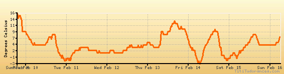
Temperature variation graph for the last seven days
Humidity Variation Graph

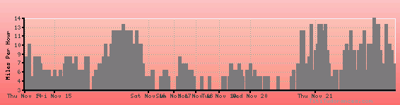
Wind speed
Weather Station: Sanford, Sanford-Lee County Regional Airport (latitude 35-34-57N, longitude 079-06-05W)
Local Time:
Sanford, Lee County is in the "America/New_York" timezone.
The "America/New_York" timezone uses a Standard Time (ST) / Daylight Saving Time (DST) alternation scheme, and it currently is in DST (since Sunday, 9 March 2025, 03:00 AM local time). During DST, the timezone abbreviation is EDT and the offset to Universal Time (UTC, GMT or Zulu) is -4:00 hours.
Sanford, Lee County will exit DST (returning to standard time) on Sunday, 2 November 2025, at 02:00 AM local time, when clocks will be turned backward 1 hour to Sunday, 2 November 2025, 01:00 AM local standard time. During ST, the timezone abbreviation is EST and the offset to UTC will be -5:00 hours.
Weather and Temperature in North Carolina
Popular Weather Searches:
 If you own or manage a travel-related business such as a hotel, a bed-and-breakfast, a restaurant, a pub or a cafeteria, you can create a web page for your business for free on Titi Tudorancea Travel Info. » |