| Published in Weather / Vermont Weather Temperature |
Weather in Saint Johnsbury, Vermont
Current Conditions (Monday, February 3, 2025 at 19:54 America/New_York time)
Temperature: 34°F (1°C) |
Forecast Overview
Tue Feb 4 
28°F 3°F -2°C -16°C Chance of light snow after 7 pm.
detailsWed Feb 5 
12°F -9°F -11°C -23°C More clouds than sun.
detailsThu Feb 6 
23°F -8°F -5°C -22°C Chance of snow almost all day.
detailsFri Feb 7 
34°F 14°F 1°C -10°C Chance of light snow until 7 pm.
detailsSat Feb 8 
19°F -2°F -7°C -19°C Chance of light snow in the morning.
detailsSun Feb 9 21°F -4°F -6°C -20°C Chance of snow until 4 pm.
detailsMon Feb 10 25°F -9°F -4°C -23°C Chance of light snow in the morning.
detailsTue Feb 11 
18°F -8°F -8°C -22°C Overcast skies.
detailsWed Feb 12 14°F -4°F -10°C -20°C Chance of light snow in the afternoon.
details
Detailed Forecast
| Monday, February 3 | sunrise: 07:05 sunset: 16:58 |
| Chance of snow from 1 pm till 1 am. Estimated precipitation: 0.15 in (3.875 mm). Overcast skies. Wind: 5 mph (8 km/h). |
| Time | Skies | Conditions | Temp | Wind | Humidity | Soil Moisture |
| 19:00 22:00 | Chance of snow. Precipitation: 0.11 in (2.75 mm). | 30°F (-1°C) | 4 mph (7 km/h) | 98% | 0.446% | |
| 22:00 01:00 | Chance of snow. Precipitation: 0.04 in (1.125 mm). | 29°F (-2°C) | 5 mph (8 km/h) | 95% | 0.446% |
| Tuesday, February 4 | sunrise: 07:04 sunset: 17:00 |
| Low around 3°F (-16°C), high around 29°F (-2°C). Chance of light snow in the evening (between 7 pm and 10 pm). Estimated precipitation: 0.02 in (0.5 mm). Mostly cloudy skies. Wind: 15 mph (24 km/h). |
| Time | Skies | Conditions | Temp | Wind | Humidity | Soil Moisture |
| 01:00 04:00 | Overcast. Precipitation: 0 in (0.0625 mm). | 22°F (-5°C) | 8 mph (13 km/h) | 86% | 0.446% | |
| 04:00 07:00 | Mostly clear, with a few passing clouds. | 13°F (-10°C) | 8 mph (12 km/h) | 90% | 0.446% | |
| 07:00 10:00 | Overcast. | 17°F (-8°C) | 12 mph (20 km/h) | 85% | 0.446% | |
| 10:00 13:00 | Overcast. Precipitation: 0 in (0.125 mm). | 17°F (-9°C) | 15 mph (24 km/h) | 83% | 0.446% | |
| 13:00 16:00 | Overcast. Precipitation: 0 in (0.125 mm). | 12°F (-11°C) | 13 mph (20 km/h) | 84% | 0.446% | |
| 16:00 19:00 | Overcast. Precipitation: 0 in (0.0625 mm). | 9°F (-13°C) | 11 mph (18 km/h) | 86% | 0.446% | |
| 19:00 22:00 | Chance of light snow. Precipitation: 0 in (0.0625 mm). | 7°F (-14°C) | 9 mph (14 km/h) | 89% | 0.446% | |
| 22:00 01:00 | Overcast. Precipitation: 0 in (0.0625 mm). | 3°F (-16°C) | 8 mph (12 km/h) | 90% | 0.446% |
| Wednesday, February 5 | sunrise: 07:03 sunset: 17:01 |
| Low around -10°F (-23°C), high around 11°F (-11°C). Estimated precipitation: 0 in (0.0625 mm). More clouds than sun. Wind: 8 mph (13 km/h). |
| Time | Skies | Conditions | Temp | Wind | Humidity | Soil Moisture |
| 01:00 04:00 | Overcast. Precipitation: 0 in (0.0625 mm). | 0°F (-18°C) | 7 mph (12 km/h) | 91% | 0.446% | |
| 04:00 07:00 | Clear. | -10°F (-23°C) | 3 mph (5 km/h) | 99% | 0.446% | |
| 07:00 10:00 | Overcast. | 4°F (-16°C) | 7 mph (11 km/h) | 80% | 0.446% | |
| 10:00 13:00 | Overcast. | 10°F (-12°C) | 8 mph (13 km/h) | 76% | 0.446% | |
| 13:00 16:00 | Overcast. | 11°F (-12°C) | 4 mph (7 km/h) | 79% | 0.446% | |
| 16:00 19:00 | Mostly clear. | -3°F (-20°C) | 1 mph (1 km/h) | 97% | 0.446% | |
| 19:00 22:00 | Clear. | -7°F (-22°C) | 0 mph (1 km/h) | 99% | 0.446% | |
| 22:00 01:00 | A few passing clouds. | -8°F (-22°C) | 1 mph (2 km/h) | 100% | 0.446% |
| Thursday, February 6 | sunrise: 07:02 sunset: 17:02 |
| Low around -8°F (-22°C), high around 22°F (-5°C). Chance of snow most of the day (from 10 am to 10 pm). Estimated precipitation: 0.28 in (7.125 mm). Overcast skies. Wind: 7 mph (11 km/h). |
| Time | Skies | Conditions | Temp | Wind | Humidity | Soil Moisture |
| 01:00 04:00 | Partly cloudy. | -7°F (-22°C) | 1 mph (1 km/h) | 99% | 0.447% | |
| 04:00 07:00 | Overcast. | -6°F (-21°C) | 1 mph (2 km/h) | 99% | 0.447% | |
| 07:00 10:00 | Overcast. | 11°F (-11°C) | 4 mph (7 km/h) | 79% | 0.447% | |
| 10:00 13:00 | Chance of light snow. Precipitation: 0.03 in (0.75 mm). | 18°F (-8°C) | 6 mph (10 km/h) | 93% | 0.447% | |
| 13:00 16:00 | Chance of snow. Precipitation: 0.14 in (3.625 mm). | 21°F (-6°C) | 7 mph (11 km/h) | 96% | 0.447% | |
| 16:00 19:00 | Chance of snow. Precipitation: 0.09 in (2.25 mm). | 20°F (-6°C) | 5 mph (8 km/h) | 97% | 0.447% | |
| 19:00 22:00 | Chance of light snow. Precipitation: 0.02 in (0.4375 mm). | 20°F (-7°C) | 4 mph (7 km/h) | 97% | 0.447% | |
| 22:00 01:00 | Overcast. Precipitation: 0 in (0.0625 mm). | 22°F (-5°C) | 5 mph (8 km/h) | 98% | 0.447% |
| Friday, February 7 | sunrise: 07:00 sunset: 17:04 |
| Low around 14°F (-10°C), high around 35°F (1°C). Chance of light snow until 7 pm. Estimated precipitation: 0.06 in (1.4375 mm). Mostly cloudy skies. Wind: 17 mph (28 km/h). |
| Time | Skies | Conditions | Temp | Wind | Humidity | Soil Moisture |
| 01:00 04:00 | Chance of light snow. Precipitation: 0.01 in (0.1875 mm). | 28°F (-2°C) | 7 mph (11 km/h) | 98% | 0.447% | |
| 04:00 07:00 | Sunny. Precipitation: 0.01 in (0.3125 mm). | 29°F (-2°C) | 17 mph (28 km/h) | 74% | 0.448% | |
| 07:00 10:00 | Chance of light snow. Precipitation: 0.01 in (0.1875 mm). | 26°F (-4°C) | 17 mph (28 km/h) | 78% | 0.448% | |
| 10:00 13:00 | Chance of light snow. Precipitation: 0.01 in (0.25 mm). | 25°F (-4°C) | 16 mph (25 km/h) | 83% | 0.448% | |
| 13:00 16:00 | Chance of light snow. Precipitation: 0.01 in (0.25 mm). | 23°F (-5°C) | 13 mph (21 km/h) | 87% | 0.448% | |
| 16:00 19:00 | Chance of light snow. Precipitation: 0 in (0.125 mm). | 21°F (-6°C) | 11 mph (17 km/h) | 88% | 0.448% | |
| 19:00 22:00 | Considerable cloudiness. Precipitation: 0 in (0.0625 mm). | 18°F (-8°C) | 10 mph (15 km/h) | 85% | 0.448% | |
| 22:00 01:00 | Overcast. Precipitation: 0 in (0.0625 mm). | 14°F (-10°C) | 7 mph (11 km/h) | 91% | 0.448% |
| Saturday, February 8 | sunrise: 06:59 sunset: 17:05 |
| Low around -2°F (-19°C), high around 20°F (-7°C). Chance of light snow all night and all morning (until 1 pm). Estimated precipitation: 0.02 in (0.625 mm). Overcast skies. Wind: 12 mph (19 km/h). |
| Time | Skies | Conditions | Temp | Wind | Humidity | Soil Moisture |
| 01:00 04:00 | Chance of light snow. Precipitation: 0 in (0.0625 mm). | 12°F (-11°C) | 5 mph (8 km/h) | 93% | 0.448% | |
| 04:00 07:00 | Chance of light snow. Precipitation: 0.01 in (0.1875 mm). | 7°F (-14°C) | 2 mph (3 km/h) | 98% | 0.448% | |
| 07:00 10:00 | Chance of light snow. Precipitation: 0 in (0.125 mm). | 18°F (-8°C) | 9 mph (14 km/h) | 79% | 0.448% | |
| 10:00 13:00 | Chance of light snow. Precipitation: 0.01 in (0.1875 mm). | 19°F (-7°C) | 12 mph (19 km/h) | 78% | 0.448% | |
| 13:00 16:00 | Overcast. Precipitation: 0 in (0.0625 mm). | 16°F (-9°C) | 7 mph (11 km/h) | 84% | 0.448% | |
| 16:00 19:00 | Overcast. | -0°F (-18°C) | 3 mph (5 km/h) | 98% | 0.448% | |
| 19:00 22:00 | Overcast. | 2°F (-16°C) | 1 mph (2 km/h) | 97% | 0.448% | |
| 22:00 01:00 | Overcast. | 8°F (-14°C) | 1 mph (1 km/h) | 93% | 0.448% |
| Sunday, February 9 | sunrise: 06:58 sunset: 17:07 |
| Low around -3°F (-20°C), high around 21°F (-6°C). Chance of snow during the morning and early afternoon (between 4 am and 4 pm). Estimated precipitation: 0.13 in (3.25 mm). Overcast skies. Wind: 4 mph (6 km/h). |
| Time | Skies | Conditions | Temp | Wind | Humidity | Soil Moisture |
| 01:00 04:00 | Overcast. | 9°F (-13°C) | 1 mph (2 km/h) | 94% | 0.448% | |
| 04:00 07:00 | Chance of light snow. Precipitation: 0 in (0.125 mm). | 10°F (-12°C) | 2 mph (3 km/h) | 95% | 0.448% | |
| 07:00 10:00 | Chance of light snow. Precipitation: 0.04 in (0.9375 mm). | 15°F (-10°C) | 2 mph (3 km/h) | 92% | 0.448% | |
| 10:00 13:00 | Chance of snow. Precipitation: 0.05 in (1.1875 mm). | 19°F (-7°C) | 1 mph (1 km/h) | 91% | 0.448% | |
| 13:00 16:00 | Chance of light snow. Precipitation: 0.03 in (0.875 mm). | 21°F (-6°C) | 0 mph (1 km/h) | 93% | 0.448% | |
| 16:00 19:00 | Partly cloudy. Precipitation: 0 in (0.125 mm). | 11°F (-12°C) | 3 mph (5 km/h) | 99% | 0.448% | |
| 19:00 22:00 | Mostly cloudy. | 2°F (-17°C) | 4 mph (6 km/h) | 100% | 0.448% | |
| 22:00 01:00 | Overcast. | -3°F (-20°C) | 4 mph (6 km/h) | 100% | 0.448% |
| Monday, February 10 | sunrise: 06:56 sunset: 17:08 |
| Low around -9°F (-23°C), high around 26°F (-4°C). Chance of light snow in the morning (between 10 am and 1 pm). Estimated precipitation: 0.01 in (0.25 mm). Overcast skies. Wind: 7 mph (11 km/h). |
| Time | Skies | Conditions | Temp | Wind | Humidity | Soil Moisture |
| 01:00 04:00 | Overcast. | -7°F (-21°C) | 3 mph (4 km/h) | 100% | 0.448% | |
| 04:00 07:00 | Overcast. | -9°F (-23°C) | 1 mph (1 km/h) | 100% | 0.448% | |
| 07:00 10:00 | More sun than clouds. | 15°F (-9°C) | 3 mph (5 km/h) | 88% | 0.449% | |
| 10:00 13:00 | Chance of light snow. Precipitation: 0 in (0.0625 mm). | 24°F (-4°C) | 7 mph (11 km/h) | 76% | 0.449% | |
| 13:00 16:00 | Mostly cloudy. Precipitation: 0 in (0.125 mm). | 25°F (-4°C) | 5 mph (9 km/h) | 80% | 0.449% | |
| 16:00 19:00 | Overcast. | 12°F (-11°C) | 3 mph (5 km/h) | 96% | 0.449% | |
| 19:00 22:00 | Considerable cloudiness. | 9°F (-13°C) | 3 mph (5 km/h) | 98% | 0.449% | |
| 22:00 01:00 | Overcast. Precipitation: 0 in (0.0625 mm). | 2°F (-17°C) | 1 mph (2 km/h) | 100% | 0.449% |
| Tuesday, February 11 | sunrise: 06:55 sunset: 17:09 |
| Low around -8°F (-22°C), high around 18°F (-8°C). Estimated precipitation: 0.01 in (0.1875 mm). Overcast skies. Wind: 10 mph (17 km/h). |
| Time | Skies | Conditions | Temp | Wind | Humidity | Soil Moisture |
| 01:00 04:00 | Overcast. | 2°F (-17°C) | 1 mph (2 km/h) | 100% | 0.449% | |
| 04:00 07:00 | Mostly cloudy. Precipitation: 0 in (0.0625 mm). | 2°F (-16°C) | 2 mph (4 km/h) | 99% | 0.449% | |
| 07:00 10:00 | Overcast. Precipitation: 0 in (0.125 mm). | 16°F (-9°C) | 10 mph (17 km/h) | 81% | 0.449% | |
| 10:00 13:00 | Mostly cloudy. | 18°F (-8°C) | 9 mph (15 km/h) | 72% | 0.449% | |
| 13:00 16:00 | Overcast. | 14°F (-10°C) | 6 mph (10 km/h) | 82% | 0.449% | |
| 16:00 19:00 | Overcast. | -2°F (-19°C) | 4 mph (6 km/h) | 98% | 0.449% | |
| 19:00 22:00 | Overcast. | -8°F (-22°C) | 4 mph (6 km/h) | 98% | 0.449% | |
| 22:00 01:00 | Overcast. | -3°F (-19°C) | 4 mph (6 km/h) | 95% | 0.449% |
| Wednesday, February 12 | sunrise: 06:54 sunset: 17:11 |
| Low around -4°F (-20°C), high around 13°F (-10°C). Chance of light snow during the afternoon (between 1 pm and 7 pm). Estimated precipitation: 0.03 in (0.75 mm). Overcast skies. Wind: 4 mph (6 km/h). |
| Time | Skies | Conditions | Temp | Wind | Humidity | Soil Moisture |
| 01:00 04:00 | Overcast. | 0°F (-18°C) | 4 mph (6 km/h) | 95% | 0.449% | |
| 04:00 07:00 | Overcast. | 2°F (-17°C) | 2 mph (4 km/h) | 91% | 0.449% | |
| 07:00 10:00 | Overcast. | 7°F (-14°C) | 3 mph (5 km/h) | 80% | 0.449% | |
| 10:00 13:00 | Overcast. Precipitation: 0 in (0.0625 mm). | 12°F (-11°C) | 3 mph (5 km/h) | 78% | 0.449% | |
| 13:00 16:00 | Chance of light snow. Precipitation: 0.01 in (0.3125 mm). | 13°F (-11°C) | 3 mph (4 km/h) | 89% | 0.449% | |
| 16:00 19:00 | Chance of light snow. Precipitation: 0.01 in (0.3125 mm). | 8°F (-13°C) | 3 mph (5 km/h) | 97% | 0.449% | |
| 19:00 22:00 | Mostly cloudy. | -2°F (-19°C) | 3 mph (5 km/h) | 99% | 0.449% | |
| 22:00 01:00 | Overcast. Precipitation: 0 in (0.0625 mm). | -4°F (-20°C) | 1 mph (2 km/h) | 100% | 0.449% |
Climate Chart
» Saint Johnsbury Climate Chart
Places with a similar climate: Morrisville (VT), Barre / Montpelier (VT), Massena (NY), Millinocket (ME), Houghton Lake, Roscommon County (MI), Plymouth (NH), Alpena County (MI), Lyndonville, Caledonia County (VT), Highgate City, Franklin County (VT), Plattsburgh (NY), Auburn-Lewiston (ME), Bangor (ME), Watertown (NY), Oscoda (MI), Jaffrey (NH), Big Rapids (MI), Fort Drum (NY), Bradford (PA), Newport City, Orleans County (VT), Menominee / Marinette County (MI), Bad Axe, Huron County (MI), Fryeburg (ME), Glens Falls (NY), Cadillac / Wexford County (MI), Rutland (VT).
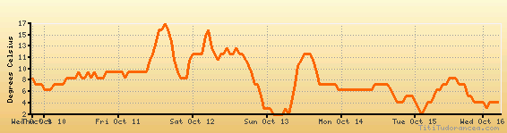
Temperature variation graph for the last seven days
Humidity Variation Graph

Weather Station: Saint Johnsbury (latitude 44-25-10N, longitude 072-01-10W)
Local Time:
Saint Johnsbury is in the "America/New_York" timezone.
The "America/New_York" timezone uses a Standard Time (ST) / Daylight Saving Time (DST) alternation scheme, and it currently is in ST (since Sunday, 3 November 2024, 01:00 AM local time). During ST, the timezone abbreviation is EST and the offset to Universal Time (UTC, GMT or Zulu) is -5:00 hours.
Saint Johnsbury will exit standard time (entering DST) on Sunday, 9 March 2025, at 02:00 AM local time, when clocks will be turned forward 1 hour to Sunday, 9 March 2025, 03:00 AM local daylight time. During DST, the timezone abbreviation is EDT and the offset to UTC will be -4:00 hours.
Weather and Temperature in Vermont
Popular Weather Searches:
 If you own or manage a travel-related business such as a hotel, a bed-and-breakfast, a restaurant, a pub or a cafeteria, you can create a web page for your business for free on Titi Tudorancea Travel Info. » |