| Published in Weather / Illinois Weather Temperature |
Weather in Rockford, Illinois
Current Conditions (Sunday, February 2, 2025 at 00:54 America/Chicago time)
Temperature: 34°F (1°C) |
Forecast Overview
Sun Feb 2 
46°F 30°F 8°C -1°C Mostly cloudy skies.
detailsMon Feb 3 39°F 28°F 4°C -2°C Mostly cloudy skies.
detailsTue Feb 4 28°F 21°F -2°C -6°C Overcast skies.
detailsWed Feb 5 
28°F 23°F -2°C -5°C Chance of snow at various times of the day.
detailsThu Feb 6 
36°F 18°F 2°C -8°C More clouds than sun.
detailsFri Feb 7 27°F 14°F -3°C -10°C Mostly cloudy skies.
detailsSat Feb 8 28°F 21°F -2°C -6°C Chance of snow after 12 pm.
detailsSun Feb 9 30°F 18°F -1°C -8°C Mostly cloudy skies.
detailsMon Feb 10 32°F 18°F 0°C -8°C Mostly cloudy skies.
details
Detailed Forecast
| Sunday, February 2 | sunrise: 07:09 sunset: 17:10 |
| Low around 31°F (-1°C), high around 46°F (8°C). Estimated precipitation: 0.01 in (0.375 mm). Mostly cloudy skies. Wind: 12 mph (19 km/h). |
| Time | Skies | Conditions | Temp | Wind | Humidity | Soil Moisture |
| 00:00 03:00 | Overcast. Precipitation: 0.01 in (0.375 mm). | 32°F (-0°C) | 12 mph (19 km/h) | 82% | 0.323% | |
| 03:00 06:00 | Overcast. | 33°F (1°C) | 7 mph (12 km/h) | 90% | 0.323% | |
| 06:00 09:00 | Considerable cloudiness. | 35°F (2°C) | 6 mph (10 km/h) | 97% | 0.324% | |
| 09:00 12:00 | Mostly sunny. | 44°F (6°C) | 8 mph (14 km/h) | 78% | 0.323% | |
| 12:00 15:00 | Times of sun and clouds. | 46°F (8°C) | 7 mph (11 km/h) | 74% | 0.321% | |
| 15:00 18:00 | Overcast. | 39°F (4°C) | 6 mph (10 km/h) | 89% | 0.318% | |
| 18:00 21:00 | Overcast. | 39°F (4°C) | 6 mph (10 km/h) | 90% | 0.315% | |
| 21:00 00:00 | Overcast. | 39°F (4°C) | 5 mph (9 km/h) | 92% | 0.313% |
| Monday, February 3 | sunrise: 07:08 sunset: 17:12 |
| Low around 28°F (-2°C), high around 40°F (4°C). Mostly cloudy skies. Wind: 13 mph (21 km/h). |
| Time | Skies | Conditions | Temp | Wind | Humidity | Soil Moisture |
| 00:00 03:00 | Overcast. | 38°F (3°C) | 4 mph (6 km/h) | 92% | 0.312% | |
| 03:00 06:00 | Overcast. | 37°F (3°C) | 2 mph (3 km/h) | 93% | 0.31% | |
| 06:00 09:00 | Overcast. | 38°F (3°C) | 7 mph (12 km/h) | 93% | 0.308% | |
| 09:00 12:00 | Overcast. | 37°F (3°C) | 13 mph (21 km/h) | 90% | 0.306% | |
| 12:00 15:00 | Overcast. | 36°F (2°C) | 9 mph (15 km/h) | 80% | 0.304% | |
| 15:00 18:00 | Overcast. | 33°F (1°C) | 10 mph (17 km/h) | 86% | 0.302% | |
| 18:00 21:00 | Overcast. | 32°F (-0°C) | 10 mph (16 km/h) | 81% | 0.301% | |
| 21:00 00:00 | Clear. | 28°F (-2°C) | 11 mph (18 km/h) | 79% | 0.299% |
| Tuesday, February 4 | sunrise: 07:07 sunset: 17:13 |
| Low around 22°F (-6°C), high around 28°F (-2°C). Overcast skies. Wind: 11 mph (18 km/h). |
| Time | Skies | Conditions | Temp | Wind | Humidity | Soil Moisture |
| 00:00 03:00 | Clear. | 25°F (-4°C) | 11 mph (18 km/h) | 68% | 0.299% | |
| 03:00 06:00 | Overcast. | 23°F (-5°C) | 11 mph (18 km/h) | 63% | 0.299% | |
| 06:00 09:00 | Overcast. | 22°F (-5°C) | 11 mph (18 km/h) | 57% | 0.3% | |
| 09:00 12:00 | Overcast. | 25°F (-4°C) | 9 mph (14 km/h) | 47% | 0.3% | |
| 12:00 15:00 | Overcast. | 27°F (-3°C) | 9 mph (15 km/h) | 45% | 0.3% | |
| 15:00 18:00 | Overcast. | 25°F (-4°C) | 10 mph (16 km/h) | 54% | 0.301% | |
| 18:00 21:00 | Overcast. | 24°F (-5°C) | 11 mph (17 km/h) | 61% | 0.302% | |
| 21:00 00:00 | Overcast. | 23°F (-5°C) | 10 mph (15 km/h) | 67% | 0.303% |
| Wednesday, February 5 | sunrise: 07:06 sunset: 17:14 |
| Low around 23°F (-5°C), high around 28°F (-2°C). Chance of snow between 9 am and 12 pm and between 3 pm and 9 pm. Estimated precipitation: 0.12 in (3 mm). Overcast skies. Wind: 12 mph (19 km/h). |
| Time | Skies | Conditions | Temp | Wind | Humidity | Soil Moisture |
| 00:00 03:00 | Overcast. | 24°F (-4°C) | 9 mph (15 km/h) | 68% | 0.305% | |
| 03:00 06:00 | Overcast. | 25°F (-4°C) | 11 mph (18 km/h) | 72% | 0.306% | |
| 06:00 09:00 | Overcast. | 27°F (-3°C) | 12 mph (19 km/h) | 69% | 0.308% | |
| 09:00 12:00 | Chance of light snow. Precipitation: 0.02 in (0.4375 mm). | 26°F (-3°C) | 11 mph (17 km/h) | 84% | 0.309% | |
| 12:00 15:00 | Overcast. Precipitation: 0.07 in (1.75 mm). | 26°F (-3°C) | 10 mph (16 km/h) | 88% | 0.31% | |
| 15:00 18:00 | Chance of light snow. Precipitation: 0 in (0.125 mm). | 26°F (-3°C) | 8 mph (13 km/h) | 89% | 0.311% | |
| 18:00 21:00 | Chance of light snow. Precipitation: 0.02 in (0.5625 mm). | 27°F (-3°C) | 6 mph (10 km/h) | 95% | 0.313% | |
| 21:00 00:00 | Overcast. Precipitation: 0 in (0.125 mm). | 27°F (-3°C) | 3 mph (5 km/h) | 93% | 0.315% |
| Thursday, February 6 | sunrise: 07:05 sunset: 17:15 |
| Low around 18°F (-8°C), high around 36°F (2°C). More clouds than sun. Wind: 19 mph (31 km/h). |
| Time | Skies | Conditions | Temp | Wind | Humidity | Soil Moisture |
| 00:00 03:00 | Overcast. | 28°F (-2°C) | 3 mph (6 km/h) | 92% | 0.316% | |
| 03:00 06:00 | Overcast. | 28°F (-2°C) | 6 mph (9 km/h) | 92% | 0.317% | |
| 06:00 09:00 | Overcast. | 30°F (-1°C) | 9 mph (15 km/h) | 88% | 0.318% | |
| 09:00 12:00 | Mostly cloudy. | 35°F (1°C) | 17 mph (27 km/h) | 72% | 0.325% | |
| 12:00 15:00 | Sunny. | 34°F (1°C) | 19 mph (31 km/h) | 53% | 0.332% | |
| 15:00 18:00 | Mostly clear, with a few passing clouds. | 26°F (-4°C) | 18 mph (29 km/h) | 50% | 0.331% | |
| 18:00 21:00 | Clear. | 23°F (-5°C) | 19 mph (31 km/h) | 50% | 0.332% | |
| 21:00 00:00 | Clear. | 18°F (-8°C) | 14 mph (23 km/h) | 57% | 0.332% |
| Friday, February 7 | sunrise: 07:04 sunset: 17:17 |
| Low around 15°F (-10°C), high around 26°F (-3°C). Mostly cloudy skies. Wind: 12 mph (19 km/h). |
| Time | Skies | Conditions | Temp | Wind | Humidity | Soil Moisture |
| 00:00 03:00 | Clear. | 16°F (-9°C) | 12 mph (19 km/h) | 59% | 0.334% | |
| 03:00 06:00 | Overcast. | 15°F (-9°C) | 10 mph (16 km/h) | 59% | 0.335% | |
| 06:00 09:00 | Overcast. | 17°F (-8°C) | 10 mph (16 km/h) | 54% | 0.337% | |
| 09:00 12:00 | Overcast. | 23°F (-5°C) | 10 mph (16 km/h) | 47% | 0.337% | |
| 12:00 15:00 | Overcast. | 26°F (-4°C) | 9 mph (15 km/h) | 44% | 0.338% | |
| 15:00 18:00 | Overcast. | 25°F (-4°C) | 5 mph (7 km/h) | 53% | 0.339% | |
| 18:00 21:00 | Partly cloudy. | 23°F (-5°C) | 3 mph (6 km/h) | 56% | 0.34% | |
| 21:00 00:00 | Overcast. | 22°F (-6°C) | 1 mph (2 km/h) | 57% | 0.341% |
| Saturday, February 8 | sunrise: 07:03 sunset: 17:18 |
| Low around 21°F (-6°C), high around 28°F (-2°C). Chance of snow during the afternoon and evening (between 12 pm and 9 pm). Estimated precipitation: 0.13 in (3.25 mm). Overcast skies. Wind: 11 mph (17 km/h). |
| Time | Skies | Conditions | Temp | Wind | Humidity | Soil Moisture |
| 00:00 03:00 | Overcast. | 22°F (-6°C) | 4 mph (7 km/h) | 60% | 0.342% | |
| 03:00 06:00 | Overcast. | 22°F (-6°C) | 6 mph (9 km/h) | 65% | 0.343% | |
| 06:00 09:00 | Overcast. | 25°F (-4°C) | 7 mph (11 km/h) | 59% | 0.344% | |
| 09:00 12:00 | Overcast. Precipitation: 0.01 in (0.375 mm). | 28°F (-2°C) | 10 mph (17 km/h) | 52% | 0.344% | |
| 12:00 15:00 | Chance of light snow. Precipitation: 0 in (0.0625 mm). | 27°F (-3°C) | 11 mph (17 km/h) | 79% | 0.345% | |
| 15:00 18:00 | Chance of snow. Precipitation: 0.05 in (1.25 mm). | 26°F (-4°C) | 7 mph (11 km/h) | 95% | 0.345% | |
| 18:00 21:00 | Chance of snow. Precipitation: 0.04 in (1.125 mm). | 26°F (-3°C) | 6 mph (9 km/h) | 97% | 0.346% | |
| 21:00 00:00 | Times of clear skies and clouds. Precipitation: 0.02 in (0.4375 mm). | 24°F (-4°C) | 9 mph (14 km/h) | 95% | 0.346% |
| Sunday, February 9 | sunrise: 07:02 sunset: 17:19 |
| Low around 18°F (-8°C), high around 31°F (-1°C). Mostly cloudy skies. Wind: 10 mph (16 km/h). |
| Time | Skies | Conditions | Temp | Wind | Humidity | Soil Moisture |
| 00:00 03:00 | Clear. | 21°F (-6°C) | 10 mph (15 km/h) | 94% | 0.347% | |
| 03:00 06:00 | A few passing clouds. | 18°F (-8°C) | 7 mph (11 km/h) | 94% | 0.348% | |
| 06:00 09:00 | Mostly cloudy. | 22°F (-6°C) | 8 mph (13 km/h) | 85% | 0.349% | |
| 09:00 12:00 | Overcast. | 29°F (-2°C) | 8 mph (13 km/h) | 78% | 0.352% | |
| 12:00 15:00 | Overcast. | 31°F (-1°C) | 10 mph (16 km/h) | 75% | 0.356% | |
| 15:00 18:00 | Overcast. | 27°F (-3°C) | 8 mph (13 km/h) | 88% | 0.356% | |
| 18:00 21:00 | Overcast. | 26°F (-4°C) | 7 mph (11 km/h) | 86% | 0.357% | |
| 21:00 00:00 | Overcast. | 25°F (-4°C) | 6 mph (9 km/h) | 89% | 0.357% |
| Monday, February 10 | sunrise: 07:00 sunset: 17:21 |
| Low around 17°F (-8°C), high around 32°F (0°C). Mostly cloudy skies. Wind: 14 mph (23 km/h). |
| Time | Skies | Conditions | Temp | Wind | Humidity | Soil Moisture |
| 00:00 03:00 | Overcast. | 25°F (-4°C) | 5 mph (8 km/h) | 91% | 0.357% | |
| 03:00 06:00 | Overcast. | 24°F (-4°C) | 4 mph (6 km/h) | 92% | 0.358% | |
| 06:00 09:00 | Overcast. | 27°F (-3°C) | 3 mph (5 km/h) | 84% | 0.358% | |
| 09:00 12:00 | Overcast. | 30°F (-1°C) | 6 mph (9 km/h) | 77% | 0.361% | |
| 12:00 15:00 | Overcast. | 32°F (0°C) | 11 mph (17 km/h) | 69% | 0.364% | |
| 15:00 18:00 | Overcast. | 28°F (-2°C) | 8 mph (14 km/h) | 79% | 0.364% | |
| 18:00 21:00 | Overcast. | 22°F (-6°C) | 14 mph (23 km/h) | 81% | 0.363% | |
| 21:00 00:00 | Clear. | 17°F (-8°C) | 11 mph (18 km/h) | 82% | 0.364% |
Climate Chart
Places with a similar climate: Davenport (IA), Iowa City (IA), Boone (IA), Aurora (IL), Clinton (IA), Savanna (IL), Sturgis (MI), Janesville / Rock County (WI), De Kalb (IL), Prairie Du Chien (WI), Valparaiso, Porter County (IN), Sterling Rockfalls (IL), Burlington (WI), Goshen (IN), Chicago (IL), Ottumwa (IA), South Bend (IN), Battle Creek (MI), Denison (IA), Perry City, Dallas County (IA), Coldwater, Branch County (MI), Hillsdale (MI), Marshall (MI), Monroe (WI), Monticello (IA).
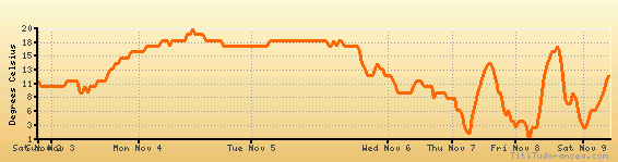
Temperature variation graph for the last seven days
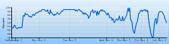
Humidity Variation Graph
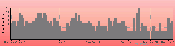
Wind speed
Weather Station: Rockford, Greater Rockford Airport (latitude 42-11-34N, longitude 089-05-36W)
Local Time:
Rockford is in the "America/Chicago" timezone.
The "America/Chicago" timezone uses a Standard Time (ST) / Daylight Saving Time (DST) alternation scheme, and it currently is in ST (since Sunday, 3 November 2024, 01:00 AM local time). During ST, the timezone abbreviation is CST and the offset to Universal Time (UTC, GMT or Zulu) is -6:00 hours.
Rockford will exit standard time (entering DST) on Sunday, 9 March 2025, at 02:00 AM local time, when clocks will be turned forward 1 hour to Sunday, 9 March 2025, 03:00 AM local daylight time. During DST, the timezone abbreviation is CDT and the offset to UTC will be -5:00 hours.
Weather and Temperature in Illinois
Popular Weather Searches:
 If you own or manage a travel-related business such as a hotel, a bed-and-breakfast, a restaurant, a pub or a cafeteria, you can create a web page for your business for free on Titi Tudorancea Travel Info. » |