| Published in Weather / Illinois Weather Temperature |
Weather in Paris, Edgar County, Illinois
Current Conditions (Tuesday, February 18, 2025 at 02:55 America/Chicago time)
Temperature: 7°F (-14°C) |
Forecast Overview
Tue Feb 18 
14°F 5°F -10°C -15°C Chance of light snow late at night.
detailsWed Feb 19 
18°F 10°F -8°C -12°C Chance of light snow most of the day.
detailsThu Feb 20 
21°F 7°F -6°C -14°C More sun than clouds.
detailsFri Feb 21 
28°F 12°F -2°C -11°C Mostly sunny, with a few passing clouds.
detailsSat Feb 22 
34°F 19°F 1°C -7°C Partly cloudy skies.
detailsSun Feb 23 
43°F 25°F 6°C -4°C Overcast skies.
detailsMon Feb 24 52°F 34°F 11°C 1°C Chance of light rain late at night.
detailsTue Feb 25 
39°F 27°F 4°C -3°C Chance of snow in the morning.
detailsWed Feb 26 43°F 27°F 6°C -3°C More sun than clouds.
details
Detailed Forecast
| Tuesday, February 18 | sunrise: 06:40 sunset: 17:29 |
| Low around 5°F (-15°C), high around 14°F (-10°C). Chance of light snow late at night (after 9 pm). Estimated precipitation: 0.02 in (0.4375 mm). Overcast skies. Wind: 11 mph (18 km/h). |
| Time | Skies | Conditions | Temp | Wind | Humidity | Soil Moisture |
| 00:00 03:00 | Overcast. Precipitation: 0 in (0.0625 mm). | 8°F (-14°C) | 11 mph (18 km/h) | 72% | 0.371% | |
| 03:00 06:00 | Overcast. Precipitation: 0 in (0.125 mm). | 6°F (-14°C) | 11 mph (18 km/h) | 71% | 0.373% | |
| 06:00 09:00 | Overcast. | 7°F (-14°C) | 10 mph (16 km/h) | 65% | 0.375% | |
| 09:00 12:00 | Overcast. | 11°F (-12°C) | 10 mph (16 km/h) | 56% | 0.377% | |
| 12:00 15:00 | Overcast. | 14°F (-10°C) | 9 mph (15 km/h) | 55% | 0.379% | |
| 15:00 18:00 | Overcast. | 12°F (-11°C) | 11 mph (17 km/h) | 67% | 0.381% | |
| 18:00 21:00 | Overcast. | 12°F (-11°C) | 11 mph (18 km/h) | 72% | 0.382% | |
| 21:00 00:00 | Chance of light snow. Precipitation: 0.01 in (0.25 mm). | 12°F (-11°C) | 10 mph (16 km/h) | 81% | 0.384% |
| Wednesday, February 19 | sunrise: 06:39 sunset: 17:30 |
| Low around 11°F (-12°C), high around 17°F (-8°C). Chance of light snow most of the day, except between 6 am and 9 am and after 9 pm. Estimated precipitation: 0.07 in (1.6875 mm). Overcast skies. Wind: 12 mph (19 km/h). |
| Time | Skies | Conditions | Temp | Wind | Humidity | Soil Moisture |
| 00:00 03:00 | Chance of light snow. Precipitation: 0 in (0.125 mm). | 12°F (-11°C) | 11 mph (17 km/h) | 87% | 0.386% | |
| 03:00 06:00 | Chance of light snow. Precipitation: 0.01 in (0.375 mm). | 11°F (-12°C) | 10 mph (16 km/h) | 89% | 0.387% | |
| 06:00 09:00 | Overcast. Precipitation: 0 in (0.125 mm). | 13°F (-11°C) | 9 mph (14 km/h) | 78% | 0.389% | |
| 09:00 12:00 | Chance of light snow. Precipitation: 0 in (0.125 mm). | 16°F (-9°C) | 10 mph (15 km/h) | 76% | 0.39% | |
| 12:00 15:00 | Chance of light snow. Precipitation: 0 in (0.125 mm). | 17°F (-8°C) | 10 mph (17 km/h) | 75% | 0.391% | |
| 15:00 18:00 | Chance of light snow. Precipitation: 0.01 in (0.375 mm). | 14°F (-10°C) | 11 mph (17 km/h) | 89% | 0.392% | |
| 18:00 21:00 | Chance of light snow. Precipitation: 0.01 in (0.3125 mm). | 12°F (-11°C) | 11 mph (17 km/h) | 88% | 0.393% | |
| 21:00 00:00 | Overcast. Precipitation: 0 in (0.125 mm). | 11°F (-12°C) | 12 mph (19 km/h) | 86% | 0.395% |
| Thursday, February 20 | sunrise: 06:38 sunset: 17:31 |
| Low around 6°F (-14°C), high around 21°F (-6°C). More sun than clouds. Wind: 13 mph (20 km/h). |
| Time | Skies | Conditions | Temp | Wind | Humidity | Soil Moisture |
| 00:00 03:00 | Considerable cloudiness. | 8°F (-13°C) | 12 mph (19 km/h) | 84% | 0.395% | |
| 03:00 06:00 | Clear. | 6°F (-14°C) | 11 mph (18 km/h) | 85% | 0.396% | |
| 06:00 09:00 | Mostly cloudy. | 11°F (-12°C) | 12 mph (20 km/h) | 77% | 0.397% | |
| 09:00 12:00 | Overcast. | 18°F (-8°C) | 13 mph (20 km/h) | 66% | 0.398% | |
| 12:00 15:00 | Partly cloudy. | 21°F (-6°C) | 13 mph (20 km/h) | 59% | 0.398% | |
| 15:00 18:00 | Clear. | 16°F (-9°C) | 6 mph (9 km/h) | 81% | 0.399% | |
| 18:00 21:00 | Clear. | 15°F (-10°C) | 6 mph (10 km/h) | 87% | 0.399% | |
| 21:00 00:00 | Clear. | 14°F (-10°C) | 6 mph (9 km/h) | 92% | 0.4% |
| Friday, February 21 | sunrise: 06:36 sunset: 17:32 |
| Low around 12°F (-11°C), high around 29°F (-2°C). Mostly sunny, with a few passing clouds. Wind: 7 mph (12 km/h). |
| Time | Skies | Conditions | Temp | Wind | Humidity | Soil Moisture |
| 00:00 03:00 | Clear. | 13°F (-11°C) | 5 mph (8 km/h) | 94% | 0.401% | |
| 03:00 06:00 | Clear. | 12°F (-11°C) | 4 mph (7 km/h) | 95% | 0.401% | |
| 06:00 09:00 | Sunny. | 19°F (-7°C) | 4 mph (6 km/h) | 78% | 0.402% | |
| 09:00 12:00 | Mostly cloudy. | 26°F (-3°C) | 6 mph (10 km/h) | 67% | 0.405% | |
| 12:00 15:00 | Partly cloudy. | 29°F (-2°C) | 7 mph (11 km/h) | 63% | 0.408% | |
| 15:00 18:00 | Clear. | 23°F (-5°C) | 3 mph (6 km/h) | 86% | 0.408% | |
| 18:00 21:00 | Clear. | 22°F (-5°C) | 7 mph (11 km/h) | 87% | 0.408% | |
| 21:00 00:00 | Clear. | 21°F (-6°C) | 7 mph (12 km/h) | 90% | 0.408% |
| Saturday, February 22 | sunrise: 06:35 sunset: 17:33 |
| Low around 19°F (-7°C), high around 33°F (1°C). Partly cloudy skies. Wind: 13 mph (22 km/h). |
| Time | Skies | Conditions | Temp | Wind | Humidity | Soil Moisture |
| 00:00 03:00 | Clear. | 20°F (-7°C) | 8 mph (12 km/h) | 92% | 0.409% | |
| 03:00 06:00 | Clear. | 19°F (-7°C) | 8 mph (13 km/h) | 93% | 0.409% | |
| 06:00 09:00 | Overcast. | 25°F (-4°C) | 9 mph (15 km/h) | 77% | 0.409% | |
| 09:00 12:00 | Overcast. | 33°F (1°C) | 11 mph (18 km/h) | 62% | 0.411% | |
| 12:00 15:00 | Overcast. | 30°F (-1°C) | 13 mph (22 km/h) | 79% | 0.412% | |
| 15:00 18:00 | Overcast. | 29°F (-2°C) | 8 mph (13 km/h) | 87% | 0.411% | |
| 18:00 21:00 | Partly cloudy. | 29°F (-2°C) | 9 mph (14 km/h) | 89% | 0.41% | |
| 21:00 00:00 | Partly cloudy. | 26°F (-3°C) | 8 mph (13 km/h) | 93% | 0.41% |
| Sunday, February 23 | sunrise: 06:34 sunset: 17:34 |
| Low around 26°F (-4°C), high around 42°F (6°C). Overcast skies. Wind: 14 mph (22 km/h). |
| Time | Skies | Conditions | Temp | Wind | Humidity | Soil Moisture |
| 00:00 03:00 | Overcast. | 26°F (-3°C) | 6 mph (10 km/h) | 94% | 0.409% | |
| 03:00 06:00 | Partly cloudy. | 26°F (-3°C) | 7 mph (11 km/h) | 94% | 0.409% | |
| 06:00 09:00 | Times of sun and clouds. | 32°F (0°C) | 11 mph (18 km/h) | 85% | 0.41% | |
| 09:00 12:00 | Overcast. | 40°F (4°C) | 13 mph (21 km/h) | 73% | 0.411% | |
| 12:00 15:00 | Overcast. | 42°F (6°C) | 14 mph (22 km/h) | 72% | 0.409% | |
| 15:00 18:00 | Overcast. | 37°F (3°C) | 8 mph (12 km/h) | 91% | 0.406% | |
| 18:00 21:00 | Overcast. | 36°F (2°C) | 12 mph (19 km/h) | 94% | 0.402% | |
| 21:00 00:00 | Overcast. | 35°F (1°C) | 8 mph (13 km/h) | 98% | 0.399% |
| Monday, February 24 | sunrise: 06:32 sunset: 17:36 |
| Low around 34°F (1°C), high around 51°F (11°C). Chance of light rain late at night (after 9 pm). Estimated precipitation: 0.01 in (0.3125 mm). Overcast skies. Wind: 18 mph (30 km/h). |
| Time | Skies | Conditions | Temp | Wind | Humidity | Soil Moisture |
| 00:00 03:00 | Overcast. | 35°F (1°C) | 10 mph (17 km/h) | 98% | 0.396% | |
| 03:00 06:00 | Overcast. | 34°F (1°C) | 10 mph (16 km/h) | 96% | 0.393% | |
| 06:00 09:00 | Overcast. | 41°F (5°C) | 13 mph (21 km/h) | 86% | 0.39% | |
| 09:00 12:00 | Overcast. | 49°F (9°C) | 18 mph (30 km/h) | 71% | 0.383% | |
| 12:00 15:00 | Overcast. | 51°F (11°C) | 15 mph (24 km/h) | 72% | 0.367% | |
| 15:00 18:00 | Overcast. | 43°F (6°C) | 8 mph (13 km/h) | 85% | 0.357% | |
| 18:00 21:00 | Overcast. | 41°F (5°C) | 7 mph (12 km/h) | 86% | 0.35% | |
| 21:00 00:00 | Chance of light rain. Precipitation: 0.01 in (0.3125 mm). | 39°F (4°C) | 7 mph (11 km/h) | 91% | 0.346% |
| Tuesday, February 25 | sunrise: 06:31 sunset: 17:37 |
| Low around 27°F (-3°C), high around 39°F (4°C). Chance of snow early in the morning (between 6 am and 9 am). Estimated precipitation: 0.1 in (2.5625 mm). Partly cloudy skies. Wind: 16 mph (25 km/h). |
| Time | Skies | Conditions | Temp | Wind | Humidity | Soil Moisture |
| 00:00 03:00 | Overcast. Precipitation: 0.1 in (2.4375 mm). | 38°F (3°C) | 9 mph (14 km/h) | 96% | 0.36% | |
| 03:00 06:00 | Overcast. | 37°F (3°C) | 13 mph (21 km/h) | 97% | 0.353% | |
| 06:00 09:00 | Chance of light snow. Precipitation: 0 in (0.0625 mm). | 35°F (2°C) | 15 mph (23 km/h) | 96% | 0.347% | |
| 09:00 12:00 | Overcast. | 37°F (3°C) | 16 mph (25 km/h) | 76% | 0.34% | |
| 12:00 15:00 | Overcast. | 38°F (4°C) | 14 mph (23 km/h) | 67% | 0.334% | |
| 15:00 18:00 | Clear. Precipitation: 0 in (0.0625 mm). | 34°F (1°C) | 10 mph (16 km/h) | 70% | 0.33% | |
| 18:00 21:00 | Clear. | 28°F (-2°C) | 6 mph (9 km/h) | 82% | 0.327% | |
| 21:00 00:00 | Clear. | 27°F (-3°C) | 4 mph (6 km/h) | 79% | 0.327% |
| Wednesday, February 26 | sunrise: 06:30 sunset: 17:38 |
| Low around 26°F (-3°C), high around 43°F (6°C). More sun than clouds. Wind: 8 mph (13 km/h). |
| Time | Skies | Conditions | Temp | Wind | Humidity | Soil Moisture |
| 00:00 03:00 | Clear. | 27°F (-3°C) | 4 mph (6 km/h) | 76% | 0.327% | |
| 03:00 06:00 | Overcast. | 26°F (-3°C) | 0 mph (1 km/h) | 75% | 0.329% | |
| 06:00 09:00 | Sunny. | 32°F (-0°C) | 3 mph (5 km/h) | 58% | 0.33% | |
| 09:00 12:00 | Sunny. | 39°F (4°C) | 6 mph (10 km/h) | 49% | 0.328% | |
| 12:00 15:00 | Sunny. | 43°F (6°C) | 7 mph (11 km/h) | 50% | 0.323% | |
| 15:00 18:00 | Clear. | 36°F (2°C) | 7 mph (12 km/h) | 71% | 0.32% | |
| 18:00 21:00 | Overcast. | 33°F (1°C) | 8 mph (13 km/h) | 80% | 0.318% | |
| 21:00 00:00 | Considerable cloudiness. | 33°F (0°C) | 8 mph (12 km/h) | 83% | 0.317% |
Climate Chart
» Paris, Edgar County Climate Chart
Places with a similar climate: Indianapolis City, Boone County (IN), Decatur (IL), Springfield (OH), Shelbyville (IN), Terre Haute (IN), Mattoon / Charleston, Coles County (IL), Lincoln, Logan County (IL), Wilmington (OH), Dayton (OH), Columbus (OH), Lafayette (IN), Bloomington, Monroe County (IN), Jacksonville (IL), Muncie, Delaware County (IN), Springfield (IL), Dayton (OH), Columbus (OH), Champaign / Urbana (IL), Pontiac (IL), Columbus / Bakalar (IN), Mount Vernon City, Knox County (OH), New Philadelphia (OH), Dayton (OH), Quincy (IL), Indianapolis (IN).
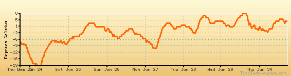
Temperature variation graph for the last seven days
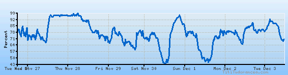
Humidity Variation Graph
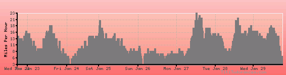
Wind speed
Weather Station: Paris, Edgar County Airport (latitude 39-42-01N, longitude 087-40-11W)
Local Time:
Paris, Edgar County is in the "America/Chicago" timezone.
The "America/Chicago" timezone uses a Standard Time (ST) / Daylight Saving Time (DST) alternation scheme, and it currently is in ST (since Sunday, 3 November 2024, 01:00 AM local time). During ST, the timezone abbreviation is CST and the offset to Universal Time (UTC, GMT or Zulu) is -6:00 hours.
Paris, Edgar County will exit standard time (entering DST) on Sunday, 9 March 2025, at 02:00 AM local time, when clocks will be turned forward 1 hour to Sunday, 9 March 2025, 03:00 AM local daylight time. During DST, the timezone abbreviation is CDT and the offset to UTC will be -5:00 hours.
Weather and Temperature in Illinois
Popular Weather Searches:
 If you own or manage a travel-related business such as a hotel, a bed-and-breakfast, a restaurant, a pub or a cafeteria, you can create a web page for your business for free on Titi Tudorancea Travel Info. » |