| Published in Weather / Wisconsin Weather Temperature |
Weather in Oshkosh, Wisconsin
Current Conditions (Friday, January 31, 2025 at 18:53 America/Chicago time)
Temperature: 36°F (2°C) |
Forecast Overview
Sat Feb 1 
28°F 14°F -2°C -10°C Chance of light snow late at night.
detailsSun Feb 2 
39°F 27°F 4°C -3°C Chance of rain in the morning. Chance of snow before sunrise.
detailsMon Feb 3 
27°F 18°F -3°C -8°C Overcast skies.
detailsTue Feb 4 
19°F 14°F -7°C -10°C Chance of light snow late at night.
detailsWed Feb 5 
30°F 18°F -1°C -8°C Chance of light snow after 6 pm.
detailsThu Feb 6 
32°F 10°F -0°C -12°C Chance of light snow before sunrise.
detailsFri Feb 7 25°F 9°F -4°C -13°C Mostly cloudy skies.
detailsSat Feb 8 
28°F 16°F -2°C -9°C Chance of snow after 12 pm.
detailsSun Feb 9 
28°F 14°F -2°C -10°C Chance of snow before sunrise.
details
Detailed Forecast
| Friday, January 31 | sunrise: 07:14 sunset: 17:01 |
| Estimated precipitation: 0 in (0.0625 mm). Overcast skies. Wind: 14 mph (23 km/h). |
| Time | Skies | Conditions | Temp | Wind | Humidity | Soil Moisture |
| 18:00 21:00 | Overcast. Precipitation: 0 in (0.0625 mm). | 26°F (-3°C) | 14 mph (23 km/h) | 81% | N/A | |
| 21:00 00:00 | Overcast. | 20°F (-7°C) | 13 mph (21 km/h) | 66% | N/A |
| Saturday, February 1 | sunrise: 07:13 sunset: 17:03 |
| Low around 15°F (-10°C), high around 29°F (-2°C). Chance of light snow late at night (after 9 pm). Estimated precipitation: 0.03 in (0.75 mm). Mostly cloudy skies. Wind: 19 mph (31 km/h). |
| Time | Skies | Conditions | Temp | Wind | Humidity | Soil Moisture |
| 00:00 03:00 | Clear. | 17°F (-8°C) | 12 mph (19 km/h) | 57% | N/A | |
| 03:00 06:00 | Clear. | 15°F (-9°C) | 9 mph (15 km/h) | 60% | N/A | |
| 06:00 09:00 | Overcast. | 17°F (-9°C) | 10 mph (16 km/h) | 68% | N/A | |
| 09:00 12:00 | Overcast. | 25°F (-4°C) | 12 mph (19 km/h) | 69% | N/A | |
| 12:00 15:00 | Overcast. | 25°F (-4°C) | 16 mph (26 km/h) | 67% | N/A | |
| 15:00 18:00 | Overcast. | 23°F (-5°C) | 16 mph (25 km/h) | 74% | N/A | |
| 18:00 21:00 | Overcast. | 27°F (-3°C) | 18 mph (28 km/h) | 71% | N/A | |
| 21:00 00:00 | Chance of light snow. Precipitation: 0.03 in (0.75 mm). | 27°F (-3°C) | 19 mph (31 km/h) | 91% | N/A |
| Sunday, February 2 | sunrise: 07:11 sunset: 17:04 |
| Low around 26°F (-3°C), high around 39°F (4°C). Chance of rain early in the morning (between 6 am and 9 am). Chance of snow between midnight and 3 am. Estimated precipitation: 0.13 in (3.25 mm). Overcast skies. Wind: 15 mph (24 km/h). |
| Time | Skies | Conditions | Temp | Wind | Humidity | Soil Moisture |
| 00:00 03:00 | Chance of snow. Precipitation: 0.11 in (2.6875 mm). | 28°F (-2°C) | 15 mph (24 km/h) | 96% | N/A | |
| 03:00 06:00 | Overcast. Precipitation: 0.02 in (0.5 mm). | 31°F (-1°C) | 11 mph (17 km/h) | 93% | N/A | |
| 06:00 09:00 | Chance of light rain. Precipitation: 0 in (0.0625 mm). | 34°F (1°C) | 11 mph (17 km/h) | 96% | N/A | |
| 09:00 12:00 | Overcast. | 38°F (3°C) | 12 mph (19 km/h) | 93% | N/A | |
| 12:00 15:00 | Overcast. | 39°F (4°C) | 14 mph (22 km/h) | 83% | N/A | |
| 15:00 18:00 | Overcast. | 34°F (1°C) | 9 mph (15 km/h) | 91% | N/A | |
| 18:00 21:00 | Times of clear skies and clouds. | 31°F (-0°C) | 13 mph (20 km/h) | 85% | N/A | |
| 21:00 00:00 | Overcast. | 26°F (-3°C) | 15 mph (24 km/h) | 67% | N/A |
| Monday, February 3 | sunrise: 07:10 sunset: 17:05 |
| Low around 18°F (-8°C), high around 27°F (-3°C). Overcast skies. Wind: 14 mph (22 km/h). |
| Time | Skies | Conditions | Temp | Wind | Humidity | Soil Moisture |
| 00:00 03:00 | Overcast. | 24°F (-5°C) | 14 mph (22 km/h) | 63% | N/A | |
| 03:00 06:00 | Overcast. | 22°F (-6°C) | 12 mph (19 km/h) | 62% | N/A | |
| 06:00 09:00 | Overcast. | 22°F (-6°C) | 13 mph (20 km/h) | 54% | N/A | |
| 09:00 12:00 | Overcast. | 25°F (-4°C) | 12 mph (19 km/h) | 50% | N/A | |
| 12:00 15:00 | Overcast. | 26°F (-4°C) | 12 mph (19 km/h) | 52% | N/A | |
| 15:00 18:00 | Overcast. | 22°F (-6°C) | 7 mph (12 km/h) | 69% | N/A | |
| 18:00 21:00 | Overcast. | 21°F (-6°C) | 11 mph (18 km/h) | 71% | N/A | |
| 21:00 00:00 | Overcast. | 18°F (-8°C) | 10 mph (17 km/h) | 73% | N/A |
| Tuesday, February 4 | sunrise: 07:09 sunset: 17:07 |
| Low around 14°F (-10°C), high around 19°F (-7°C). Chance of light snow late at night (after 9 pm). Estimated precipitation: 0.03 in (0.8125 mm). Overcast skies. Wind: 10 mph (16 km/h). |
| Time | Skies | Conditions | Temp | Wind | Humidity | Soil Moisture |
| 00:00 03:00 | Overcast. | 16°F (-9°C) | 10 mph (16 km/h) | 74% | N/A | |
| 03:00 06:00 | Overcast. | 14°F (-10°C) | 8 mph (13 km/h) | 76% | N/A | |
| 06:00 09:00 | Overcast. | 15°F (-9°C) | 9 mph (14 km/h) | 69% | N/A | |
| 09:00 12:00 | Overcast. | 17°F (-8°C) | 7 mph (12 km/h) | 66% | N/A | |
| 12:00 15:00 | Overcast. Precipitation: 0 in (0.125 mm). | 18°F (-8°C) | 4 mph (7 km/h) | 71% | N/A | |
| 15:00 18:00 | Overcast. | 19°F (-7°C) | 5 mph (8 km/h) | 68% | N/A | |
| 18:00 21:00 | Overcast. | 18°F (-8°C) | 7 mph (11 km/h) | 73% | N/A | |
| 21:00 00:00 | Chance of light snow. Precipitation: 0.03 in (0.6875 mm). | 18°F (-8°C) | 5 mph (8 km/h) | 93% | N/A |
| Wednesday, February 5 | sunrise: 07:08 sunset: 17:08 |
| Low around 18°F (-8°C), high around 29°F (-1°C). Chance of light snow in the evening and during the night (after 6 pm). Estimated precipitation: 0.03 in (0.8125 mm). Overcast skies. Wind: 9 mph (14 km/h). |
| Time | Skies | Conditions | Temp | Wind | Humidity | Soil Moisture |
| 00:00 03:00 | Overcast. Precipitation: 0.01 in (0.25 mm). | 18°F (-8°C) | 7 mph (11 km/h) | 91% | N/A | |
| 03:00 06:00 | Overcast. | 18°F (-8°C) | 7 mph (11 km/h) | 93% | N/A | |
| 06:00 09:00 | Overcast. Precipitation: 0 in (0.0625 mm). | 20°F (-7°C) | 9 mph (14 km/h) | 91% | N/A | |
| 09:00 12:00 | Overcast. | 27°F (-3°C) | 6 mph (10 km/h) | 78% | N/A | |
| 12:00 15:00 | Overcast. | 29°F (-2°C) | 9 mph (14 km/h) | 78% | N/A | |
| 15:00 18:00 | Overcast. | 27°F (-3°C) | 9 mph (14 km/h) | 86% | N/A | |
| 18:00 21:00 | Chance of light snow. Precipitation: 0 in (0.0625 mm). | 27°F (-3°C) | 6 mph (9 km/h) | 90% | N/A | |
| 21:00 00:00 | Chance of light snow. Precipitation: 0.02 in (0.4375 mm). | 27°F (-3°C) | 4 mph (7 km/h) | 97% | N/A |
| Thursday, February 6 | sunrise: 07:07 sunset: 17:10 |
| Low around 11°F (-12°C), high around 32°F (-0°C). Chance of light snow before sunrise (from midnight to 6 am). Estimated precipitation: 0.04 in (1 mm). Mostly cloudy skies. Wind: 27 mph (43 km/h). |
| Time | Skies | Conditions | Temp | Wind | Humidity | Soil Moisture |
| 00:00 03:00 | Chance of light snow. Precipitation: 0.02 in (0.4375 mm). | 28°F (-2°C) | 4 mph (7 km/h) | 97% | N/A | |
| 03:00 06:00 | Chance of light snow. Precipitation: 0.01 in (0.375 mm). | 27°F (-3°C) | 6 mph (9 km/h) | 96% | N/A | |
| 06:00 09:00 | Mostly cloudy. Precipitation: 0.01 in (0.1875 mm). | 29°F (-2°C) | 15 mph (24 km/h) | 92% | N/A | |
| 09:00 12:00 | Overcast. | 31°F (-1°C) | 24 mph (39 km/h) | 71% | N/A | |
| 12:00 15:00 | Considerable cloudiness. | 26°F (-3°C) | 27 mph (43 km/h) | 57% | N/A | |
| 15:00 18:00 | Mostly cloudy. | 15°F (-9°C) | 26 mph (42 km/h) | 65% | N/A | |
| 18:00 21:00 | Mostly clear. | 12°F (-11°C) | 21 mph (35 km/h) | 70% | N/A | |
| 21:00 00:00 | Partly cloudy. | 11°F (-12°C) | 18 mph (28 km/h) | 74% | N/A |
| Friday, February 7 | sunrise: 07:06 sunset: 17:11 |
| Low around 9°F (-13°C), high around 24°F (-4°C). Mostly cloudy skies. Wind: 16 mph (25 km/h). |
| Time | Skies | Conditions | Temp | Wind | Humidity | Soil Moisture |
| 00:00 03:00 | Clear. | 10°F (-12°C) | 16 mph (25 km/h) | 76% | N/A | |
| 03:00 06:00 | Clear. | 9°F (-13°C) | 12 mph (20 km/h) | 78% | N/A | |
| 06:00 09:00 | Sunny. | 13°F (-11°C) | 13 mph (21 km/h) | 72% | N/A | |
| 09:00 12:00 | Overcast. | 20°F (-7°C) | 14 mph (23 km/h) | 55% | N/A | |
| 12:00 15:00 | Overcast. | 24°F (-4°C) | 14 mph (23 km/h) | 50% | N/A | |
| 15:00 18:00 | Overcast. | 22°F (-6°C) | 7 mph (11 km/h) | 63% | N/A | |
| 18:00 21:00 | Overcast. | 21°F (-6°C) | 4 mph (7 km/h) | 70% | N/A | |
| 21:00 00:00 | Overcast. | 20°F (-7°C) | 4 mph (7 km/h) | 79% | N/A |
| Saturday, February 8 | sunrise: 07:04 sunset: 17:12 |
| Low around 16°F (-9°C), high around 28°F (-2°C). Chance of snow from 12 pm till midnight. Estimated precipitation: 0.17 in (4.3125 mm). Overcast skies. Wind: 12 mph (19 km/h). |
| Time | Skies | Conditions | Temp | Wind | Humidity | Soil Moisture |
| 00:00 03:00 | Mostly cloudy. | 18°F (-8°C) | 4 mph (7 km/h) | 84% | N/A | |
| 03:00 06:00 | Overcast. | 17°F (-8°C) | 4 mph (7 km/h) | 86% | N/A | |
| 06:00 09:00 | Overcast. | 20°F (-7°C) | 7 mph (11 km/h) | 77% | N/A | |
| 09:00 12:00 | Overcast. | 26°F (-3°C) | 11 mph (17 km/h) | 71% | N/A | |
| 12:00 15:00 | Chance of light snow. Precipitation: 0.01 in (0.25 mm). | 27°F (-3°C) | 10 mph (15 km/h) | 92% | N/A | |
| 15:00 18:00 | Chance of snow. Precipitation: 0.05 in (1.1875 mm). | 27°F (-3°C) | 10 mph (16 km/h) | 96% | N/A | |
| 18:00 21:00 | Chance of snow. Precipitation: 0.05 in (1.3125 mm). | 27°F (-3°C) | 12 mph (19 km/h) | 97% | N/A | |
| 21:00 00:00 | Chance of snow. Precipitation: 0.06 in (1.5625 mm). | 28°F (-2°C) | 8 mph (13 km/h) | 98% | N/A |
| Sunday, February 9 | sunrise: 07:03 sunset: 17:14 |
| Low around 13°F (-10°C), high around 28°F (-2°C). Chance of snow before sunrise (from midnight to 6 am). Estimated precipitation: 0.11 in (2.8125 mm). Mostly cloudy skies. Wind: 18 mph (29 km/h). |
| Time | Skies | Conditions | Temp | Wind | Humidity | Soil Moisture |
| 00:00 03:00 | Chance of snow. Precipitation: 0.09 in (2.375 mm). | 27°F (-3°C) | 12 mph (19 km/h) | 97% | N/A | |
| 03:00 06:00 | Chance of light snow. Precipitation: 0.01 in (0.25 mm). | 25°F (-4°C) | 11 mph (17 km/h) | 96% | N/A | |
| 06:00 09:00 | Overcast. Precipitation: 0 in (0.0625 mm). | 25°F (-4°C) | 15 mph (24 km/h) | 93% | N/A | |
| 09:00 12:00 | Overcast. Precipitation: 0 in (0.0625 mm). | 27°F (-3°C) | 18 mph (29 km/h) | 87% | N/A | |
| 12:00 15:00 | Overcast. | 28°F (-2°C) | 13 mph (21 km/h) | 82% | N/A | |
| 15:00 18:00 | Overcast. Precipitation: 0 in (0.0625 mm). | 26°F (-4°C) | 9 mph (15 km/h) | 86% | N/A | |
| 18:00 21:00 | Overcast. | 20°F (-7°C) | 10 mph (16 km/h) | 88% | N/A | |
| 21:00 00:00 | Mostly clear, with a few passing clouds. | 13°F (-10°C) | 8 mph (13 km/h) | 93% | N/A |
Climate Chart
Places with a similar climate: Fond Du Lac County (WI), Appleton / Outagamie (WI), Madison, Dane County (WI), Green Bay (WI), Baraboo (WI), West Bend (WI), Dubuque (IA), Juneau, Dodge County (WI), Menomonie (WI), Oelwein (IA), Preston, Fillmore County (MN), Winona (MN), Charles City (IA), Sheboygan County (WI), Decorah (IA), Shawano City, County (WI), Monroe (WI), Freeport (IL), Montreal, Quebec (Canada), La Crosse (WI), South St. Paul (MN), Minneapolis / Blaine (MN), Lone Rock (WI), Waupaca (WI), Clintonville (WI).
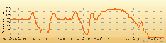
Temperature variation graph for the last seven days
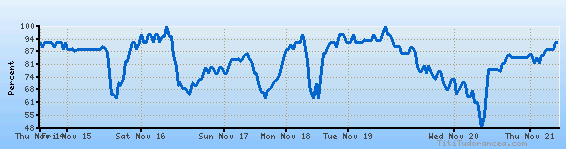
Humidity Variation Graph
Wind speed

Weather Station: Oshkosh, Wittman Regional Airport (latitude 43-58-00N, longitude 088-33-29W)
Local Time:
Oshkosh is in the "America/Chicago" timezone.
The "America/Chicago" timezone uses a Standard Time (ST) / Daylight Saving Time (DST) alternation scheme, and it currently is in ST (since Sunday, 3 November 2024, 01:00 AM local time). During ST, the timezone abbreviation is CST and the offset to Universal Time (UTC, GMT or Zulu) is -6:00 hours.
Oshkosh will exit standard time (entering DST) on Sunday, 9 March 2025, at 02:00 AM local time, when clocks will be turned forward 1 hour to Sunday, 9 March 2025, 03:00 AM local daylight time. During DST, the timezone abbreviation is CDT and the offset to UTC will be -5:00 hours.
Weather and Temperature in Wisconsin
Popular Weather Searches:
 If you own or manage a travel-related business such as a hotel, a bed-and-breakfast, a restaurant, a pub or a cafeteria, you can create a web page for your business for free on Titi Tudorancea Travel Info. » |