| Published in Weather / Iowa Weather Temperature |
Weather in Oelwein, Iowa
Current Conditions (Thursday, February 27, 2025 at 06:15 America/Chicago time)
Temperature: 34°F (1°C) |
Forecast Overview
Thu Feb 27 
46°F 34°F 8°C 1°C Partly cloudy skies.
detailsFri Feb 28 
50°F 27°F 10°C -3°C Times of sun and clouds.
detailsSat Mar 1 
30°F 21°F -1°C -6°C Sunny skies.
detailsSun Mar 2 39°F 21°F 4°C -6°C Partly cloudy skies.
detailsMon Mar 3 
46°F 28°F 8°C -2°C Chance of light, freezing rain before sunrise.
detailsTue Mar 4 
48°F 39°F 9°C 4°C Chance of rain in the afternoon and in the evening.
detailsWed Mar 5 
43°F 27°F 6°C -3°C Chance of light snow until 3 pm.
detailsThu Mar 6 39°F 25°F 4°C -4°C More sun than clouds.
detailsFri Mar 7 43°F 27°F 6°C -3°C Considerable cloudiness.
details
Detailed Forecast
| Thursday, February 27 | sunrise: 06:48 sunset: 17:53 |
| Low around 35°F (1°C), high around 46°F (8°C). Partly cloudy skies. Wind: 18 mph (29 km/h). |
| Time | Skies | Conditions | Temp | Wind | Humidity | Soil Moisture |
| 00:00 03:00 | Clear. | 35°F (2°C) | 8 mph (13 km/h) | 82% | 0.248% | |
| 03:00 06:00 | Clear. | 36°F (2°C) | 15 mph (25 km/h) | 78% | 0.247% | |
| 06:00 09:00 | Overcast. | 36°F (2°C) | 18 mph (29 km/h) | 75% | 0.245% | |
| 09:00 12:00 | Considerable cloudiness. | 39°F (4°C) | 18 mph (28 km/h) | 59% | 0.242% | |
| 12:00 15:00 | Overcast. | 46°F (8°C) | 17 mph (27 km/h) | 44% | 0.238% | |
| 15:00 18:00 | Clear. | 40°F (5°C) | 7 mph (11 km/h) | 60% | 0.235% | |
| 18:00 21:00 | Mostly cloudy. | 38°F (3°C) | 6 mph (9 km/h) | 67% | 0.234% | |
| 21:00 00:00 | Overcast. | 36°F (2°C) | 10 mph (16 km/h) | 76% | 0.233% |
| Friday, February 28 | sunrise: 06:47 sunset: 17:54 |
| Low around 27°F (-3°C), high around 50°F (10°C). Estimated precipitation: 0 in (0.0625 mm). Times of sun and clouds. Wind: 25 mph (40 km/h). |
| Time | Skies | Conditions | Temp | Wind | Humidity | Soil Moisture |
| 00:00 03:00 | Overcast. | 39°F (4°C) | 15 mph (24 km/h) | 69% | 0.232% | |
| 03:00 06:00 | Overcast. | 41°F (5°C) | 16 mph (26 km/h) | 59% | 0.231% | |
| 06:00 09:00 | Sunny. | 46°F (8°C) | 20 mph (33 km/h) | 53% | 0.23% | |
| 09:00 12:00 | A few passing clouds. | 49°F (10°C) | 25 mph (40 km/h) | 50% | 0.226% | |
| 12:00 15:00 | A few passing clouds. | 49°F (9°C) | 25 mph (40 km/h) | 48% | 0.223% | |
| 15:00 18:00 | Clear. Precipitation: 0 in (0.0625 mm). | 36°F (2°C) | 25 mph (40 km/h) | 50% | 0.222% | |
| 18:00 21:00 | Times of clear skies and clouds. | 30°F (-1°C) | 19 mph (31 km/h) | 58% | 0.221% | |
| 21:00 00:00 | Clear. | 27°F (-3°C) | 16 mph (26 km/h) | 60% | 0.22% |
| Saturday, March 1 | sunrise: 06:45 sunset: 17:56 |
| Low around 21°F (-6°C), high around 30°F (-1°C). Sunny skies. Wind: 16 mph (26 km/h). |
| Time | Skies | Conditions | Temp | Wind | Humidity | Soil Moisture |
| 00:00 03:00 | Clear. | 25°F (-4°C) | 14 mph (23 km/h) | 62% | 0.221% | |
| 03:00 06:00 | Clear. | 22°F (-6°C) | 15 mph (25 km/h) | 59% | 0.222% | |
| 06:00 09:00 | Sunny. | 22°F (-6°C) | 16 mph (26 km/h) | 41% | 0.224% | |
| 09:00 12:00 | Sunny. | 27°F (-3°C) | 11 mph (18 km/h) | 27% | 0.224% | |
| 12:00 15:00 | Sunny. | 30°F (-1°C) | 9 mph (14 km/h) | 23% | 0.223% | |
| 15:00 18:00 | Clear. | 25°F (-4°C) | 5 mph (8 km/h) | 32% | 0.223% | |
| 18:00 21:00 | Clear. | 23°F (-5°C) | 4 mph (7 km/h) | 37% | 0.224% | |
| 21:00 00:00 | A few passing clouds. | 23°F (-5°C) | 3 mph (5 km/h) | 37% | 0.225% |
| Sunday, March 2 | sunrise: 06:44 sunset: 17:57 |
| Low around 21°F (-6°C), high around 38°F (4°C). Partly cloudy skies. Wind: 9 mph (15 km/h). |
| Time | Skies | Conditions | Temp | Wind | Humidity | Soil Moisture |
| 00:00 03:00 | Partly cloudy. | 22°F (-6°C) | 3 mph (5 km/h) | 37% | 0.227% | |
| 03:00 06:00 | Mostly cloudy. | 22°F (-6°C) | 4 mph (6 km/h) | 37% | 0.229% | |
| 06:00 09:00 | Overcast. | 26°F (-3°C) | 6 mph (9 km/h) | 30% | 0.231% | |
| 09:00 12:00 | More clouds than sun. | 34°F (1°C) | 6 mph (10 km/h) | 23% | 0.232% | |
| 12:00 15:00 | Mostly sunny, with a few passing clouds. | 38°F (3°C) | 8 mph (13 km/h) | 26% | 0.231% | |
| 15:00 18:00 | Clear. | 32°F (0°C) | 7 mph (12 km/h) | 42% | 0.229% | |
| 18:00 21:00 | Mostly clear. | 29°F (-2°C) | 8 mph (13 km/h) | 51% | 0.229% | |
| 21:00 00:00 | Overcast. | 29°F (-2°C) | 9 mph (15 km/h) | 52% | 0.229% |
| Monday, March 3 | sunrise: 06:42 sunset: 17:58 |
| Low around 29°F (-2°C), high around 46°F (8°C). Chance of light, freezing rain before sunrise (between 3 am and 6 am). Estimated precipitation: 0.03 in (0.75 mm). Mostly cloudy skies. Wind: 17 mph (28 km/h). |
| Time | Skies | Conditions | Temp | Wind | Humidity | Soil Moisture |
| 00:00 03:00 | Overcast. | 32°F (-0°C) | 10 mph (16 km/h) | 51% | 0.229% | |
| 03:00 06:00 | Possibly freezing rain leading to formation of glaze ice. Precipitation: 0.02 in (0.5 mm). | 30°F (-1°C) | 12 mph (19 km/h) | 87% | 0.232% | |
| 06:00 09:00 | Overcast. Precipitation: 0.01 in (0.25 mm). | 34°F (1°C) | 13 mph (21 km/h) | 65% | 0.234% | |
| 09:00 12:00 | Overcast. | 37°F (3°C) | 14 mph (23 km/h) | 63% | 0.234% | |
| 12:00 15:00 | Sunny. | 46°F (8°C) | 17 mph (28 km/h) | 54% | 0.233% | |
| 15:00 18:00 | Mostly clear. | 41°F (5°C) | 11 mph (17 km/h) | 70% | 0.233% | |
| 18:00 21:00 | Overcast. | 41°F (5°C) | 16 mph (26 km/h) | 73% | 0.232% | |
| 21:00 00:00 | Overcast. | 41°F (5°C) | 16 mph (26 km/h) | 78% | 0.231% |
| Tuesday, March 4 | sunrise: 06:40 sunset: 17:59 |
| Low around 39°F (4°C), high around 49°F (9°C). Chance of rain late in the afternoon and in the evening (between 3 pm and 9 pm). Estimated precipitation: 0.18 in (4.6875 mm). Overcast skies. Wind: 17 mph (27 km/h). |
| Time | Skies | Conditions | Temp | Wind | Humidity | Soil Moisture |
| 00:00 03:00 | Overcast. | 40°F (4°C) | 14 mph (23 km/h) | 80% | 0.231% | |
| 03:00 06:00 | Overcast. | 40°F (4°C) | 14 mph (22 km/h) | 82% | 0.23% | |
| 06:00 09:00 | Overcast. | 41°F (5°C) | 13 mph (21 km/h) | 82% | 0.23% | |
| 09:00 12:00 | Overcast. | 48°F (9°C) | 17 mph (27 km/h) | 78% | 0.229% | |
| 12:00 15:00 | Overcast. Precipitation: 0 in (0.0625 mm). | 47°F (8°C) | 12 mph (19 km/h) | 87% | 0.228% | |
| 15:00 18:00 | Chance of rain. Precipitation: 0.05 in (1.25 mm). | 46°F (8°C) | 8 mph (13 km/h) | 98% | 0.239% | |
| 18:00 21:00 | Chance of rain. Precipitation: 0.12 in (3 mm). | 46°F (8°C) | 4 mph (6 km/h) | 99% | 0.271% | |
| 21:00 00:00 | Overcast. Precipitation: 0.01 in (0.375 mm). | 43°F (6°C) | 14 mph (23 km/h) | 95% | 0.272% |
| Wednesday, March 5 | sunrise: 06:39 sunset: 18:01 |
| Low around 26°F (-3°C), high around 42°F (6°C). Chance of light snow during the morning and early afternoon (between 3 am and 3 pm). Estimated precipitation: 0.07 in (1.6875 mm). Overcast skies. Wind: 23 mph (37 km/h). |
| Time | Skies | Conditions | Temp | Wind | Humidity | Soil Moisture |
| 00:00 03:00 | Overcast. | 35°F (2°C) | 18 mph (29 km/h) | 95% | 0.271% | |
| 03:00 06:00 | Chance of light snow. Precipitation: 0.01 in (0.375 mm). | 32°F (0°C) | 20 mph (32 km/h) | 89% | 0.27% | |
| 06:00 09:00 | Chance of light snow. Precipitation: 0.02 in (0.5 mm). | 31°F (-0°C) | 22 mph (36 km/h) | 88% | 0.268% | |
| 09:00 12:00 | Chance of light snow. Precipitation: 0.02 in (0.4375 mm). | 33°F (0°C) | 23 mph (37 km/h) | 79% | 0.267% | |
| 12:00 15:00 | Chance of light snow. Precipitation: 0.01 in (0.3125 mm). | 33°F (0°C) | 21 mph (34 km/h) | 72% | 0.267% | |
| 15:00 18:00 | Overcast. Precipitation: 0 in (0.0625 mm). | 30°F (-1°C) | 20 mph (33 km/h) | 70% | 0.265% | |
| 18:00 21:00 | Overcast. | 28°F (-2°C) | 19 mph (30 km/h) | 68% | 0.265% | |
| 21:00 00:00 | Overcast. | 26°F (-3°C) | 18 mph (29 km/h) | 63% | 0.265% |
| Thursday, March 6 | sunrise: 06:37 sunset: 18:02 |
| Low around 24°F (-4°C), high around 40°F (4°C). More sun than clouds. Wind: 18 mph (29 km/h). |
| Time | Skies | Conditions | Temp | Wind | Humidity | Soil Moisture |
| 00:00 03:00 | Clear. | 25°F (-4°C) | 15 mph (24 km/h) | 67% | 0.266% | |
| 03:00 06:00 | Clear. | 24°F (-4°C) | 12 mph (19 km/h) | 68% | 0.267% | |
| 06:00 09:00 | Sunny. | 30°F (-1°C) | 13 mph (21 km/h) | 60% | 0.269% | |
| 09:00 12:00 | Overcast. | 37°F (3°C) | 17 mph (27 km/h) | 49% | 0.27% | |
| 12:00 15:00 | Overcast. | 40°F (4°C) | 18 mph (29 km/h) | 44% | 0.27% | |
| 15:00 18:00 | Mostly sunny. | 34°F (1°C) | 10 mph (17 km/h) | 60% | 0.268% | |
| 18:00 21:00 | Clear. | 29°F (-2°C) | 8 mph (12 km/h) | 75% | 0.267% | |
| 21:00 00:00 | Clear. | 26°F (-3°C) | 5 mph (8 km/h) | 79% | 0.267% |
| Friday, March 7 | sunrise: 06:35 sunset: 18:03 |
| Low around 26°F (-3°C), high around 43°F (6°C). Considerable cloudiness. Wind: 14 mph (22 km/h). |
| Time | Skies | Conditions | Temp | Wind | Humidity | Soil Moisture |
| 00:00 03:00 | Partly cloudy. | 26°F (-3°C) | 4 mph (7 km/h) | 64% | 0.268% | |
| 03:00 06:00 | Overcast. | 26°F (-3°C) | 2 mph (3 km/h) | 55% | 0.269% | |
| 06:00 09:00 | Overcast. | 31°F (-1°C) | 4 mph (7 km/h) | 49% | 0.271% | |
| 09:00 12:00 | More clouds than sun. | 39°F (4°C) | 8 mph (13 km/h) | 50% | 0.27% | |
| 12:00 15:00 | Overcast. | 42°F (6°C) | 10 mph (16 km/h) | 56% | 0.267% | |
| 15:00 18:00 | Partly cloudy. | 38°F (3°C) | 14 mph (22 km/h) | 71% | 0.265% | |
| 18:00 21:00 | Clear. | 34°F (1°C) | 12 mph (19 km/h) | 78% | 0.264% | |
| 21:00 00:00 | A few passing clouds. | 32°F (-0°C) | 10 mph (15 km/h) | 84% | 0.263% |
Climate Chart
Places with a similar climate: Marshalltown (IA), Cedar Rapids (IA), Algona (IA), Charles City (IA), Dubuque (IA), Webster City (IA), Decorah (IA), Vinton (IA), Madison, Dane County (WI), Waterloo (IA), Winona (MN), Lone Rock (WI), La Crosse (WI), Fort Dodge (IA), Freeport (IL), Fond Du Lac County (WI), Baraboo (WI), Juneau, Dodge County (WI), Orange City (IA), Preston, Fillmore County (MN), Monroe (WI), Ames (IA), Oshkosh (WI), Sheldon (IA), Prairie Du Chien (WI).
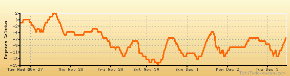
Temperature variation graph for the last seven days
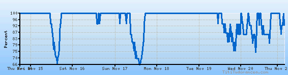
Humidity Variation Graph
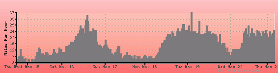
Wind speed
Weather Station: Oelwein, Oelwein Municipal Airport (latitude 42-40-51N, longitude 091-58-28W)
Local Time:
Oelwein is in the "America/Chicago" timezone.
The "America/Chicago" timezone uses a Standard Time (ST) / Daylight Saving Time (DST) alternation scheme, and it currently is in ST (since Sunday, 3 November 2024, 01:00 AM local time). During ST, the timezone abbreviation is CST and the offset to Universal Time (UTC, GMT or Zulu) is -6:00 hours.
Oelwein will exit standard time (entering DST) on Sunday, 9 March 2025, at 02:00 AM local time, when clocks will be turned forward 1 hour to Sunday, 9 March 2025, 03:00 AM local daylight time. During DST, the timezone abbreviation is CDT and the offset to UTC will be -5:00 hours.
Weather and Temperature in Iowa
Popular Weather Searches:
 If you own or manage a travel-related business such as a hotel, a bed-and-breakfast, a restaurant, a pub or a cafeteria, you can create a web page for your business for free on Titi Tudorancea Travel Info. » |