| Published in Weather / France Weather Temperature |
Weather in Nancy / Essey, France
Current Conditions (Thursday, March 13, 2025 at 19:00 Europe/Paris time)
Temperature: 37°F (3°C) |
Forecast Overview
Fri Mar 14 
41°F 34°F 5°C 1°C Chance of light rain in the afternoon.
detailsSat Mar 15 39°F 30°F 4°C -1°C Chance of light rain in the morning and in the afternoon.
detailsSun Mar 16 
45°F 34°F 7°C 1°C Chance of light rain before sunrise.
detailsMon Mar 17 
50°F 32°F 10°C -0°C Sunny skies.
detailsTue Mar 18 48°F 32°F 9°C -0°C Sunny skies.
detailsWed Mar 19 55°F 32°F 13°C -0°C Sunny skies.
detailsThu Mar 20 
59°F 39°F 15°C 4°C Partly cloudy skies.
detailsFri Mar 21 
61°F 41°F 16°C 5°C Chance of light rain late at night.
detailsSat Mar 22 
55°F 48°F 13°C 9°C Chance of light rain at various times.
details
Detailed Forecast
| Thursday, March 13 | sunrise: 06:55 sunset: 18:35 |
| Chance of light rain early in the afternoon (between 1 pm and 4 pm). Chance of light snow in the morning (between 7 am and 1 pm). Estimated precipitation: 0.03 in (0.8125 mm). Overcast skies. Wind: 4 mph (7 km/h). |
| Time | Skies | Conditions | Temp | Wind | Humidity | Soil Moisture |
| 19:00 22:00 | Overcast. Precipitation: 0.02 in (0.625 mm). | 35°F (2°C) | 4 mph (7 km/h) | 100% | 0.365% | |
| 22:00 01:00 | Overcast. Precipitation: 0.01 in (0.1875 mm). | 34°F (1°C) | 3 mph (5 km/h) | 99% | 0.361% |
| Friday, March 14 | sunrise: 06:53 sunset: 18:36 |
| Low around 34°F (1°C), high around 41°F (5°C). Chance of light rain during the afternoon (between 1 pm and 7 pm). Estimated precipitation: 0.01 in (0.375 mm). Overcast skies. Wind: 8 mph (13 km/h). |
| Time | Skies | Conditions | Temp | Wind | Humidity | Soil Moisture |
| 01:00 04:00 | Overcast. | 35°F (2°C) | 0 mph (1 km/h) | 96% | 0.358% | |
| 04:00 07:00 | Overcast. Precipitation: 0 in (0.0625 mm). | 34°F (1°C) | 1 mph (1 km/h) | 97% | 0.356% | |
| 07:00 10:00 | Overcast. | 36°F (2°C) | 4 mph (6 km/h) | 92% | 0.355% | |
| 10:00 13:00 | Overcast. Precipitation: 0 in (0.0625 mm). | 38°F (3°C) | 5 mph (8 km/h) | 86% | 0.355% | |
| 13:00 16:00 | Chance of light rain. Precipitation: 0 in (0.125 mm). | 40°F (4°C) | 7 mph (11 km/h) | 84% | 0.353% | |
| 16:00 19:00 | Chance of light rain. Precipitation: 0 in (0.0625 mm). | 38°F (3°C) | 7 mph (11 km/h) | 86% | 0.352% | |
| 19:00 22:00 | Overcast. | 37°F (3°C) | 5 mph (9 km/h) | 85% | 0.351% | |
| 22:00 01:00 | Overcast. Precipitation: 0 in (0.0625 mm). | 36°F (2°C) | 8 mph (13 km/h) | 87% | 0.349% |
| Saturday, March 15 | sunrise: 06:51 sunset: 18:38 |
| Low around 31°F (-1°C), high around 40°F (4°C). Chance of light rain in the morning and early afternoon (between 10 am and 4 pm). Estimated precipitation: 0.01 in (0.375 mm). Overcast skies. Wind: 15 mph (25 km/h). |
| Time | Skies | Conditions | Temp | Wind | Humidity | Soil Moisture |
| 01:00 04:00 | Overcast. | 34°F (1°C) | 10 mph (16 km/h) | 87% | 0.349% | |
| 04:00 07:00 | Overcast. | 31°F (-0°C) | 9 mph (14 km/h) | 85% | 0.347% | |
| 07:00 10:00 | Overcast. | 38°F (3°C) | 14 mph (22 km/h) | 74% | 0.346% | |
| 10:00 13:00 | Chance of light rain. Precipitation: 0 in (0.0625 mm). | 39°F (4°C) | 15 mph (25 km/h) | 84% | 0.344% | |
| 13:00 16:00 | Chance of light rain. Precipitation: 0.01 in (0.25 mm). | 37°F (3°C) | 12 mph (20 km/h) | 96% | 0.345% | |
| 16:00 19:00 | Overcast. Precipitation: 0 in (0.0625 mm). | 38°F (3°C) | 12 mph (20 km/h) | 96% | 0.345% | |
| 19:00 22:00 | Overcast. | 38°F (3°C) | 13 mph (20 km/h) | 90% | 0.345% | |
| 22:00 01:00 | Overcast. | 37°F (3°C) | 13 mph (20 km/h) | 95% | 0.344% |
| Sunday, March 16 | sunrise: 06:49 sunset: 18:39 |
| Low around 34°F (1°C), high around 45°F (7°C). Chance of light rain between 1 am and 4 am. Estimated precipitation: 0.02 in (0.5625 mm). Considerable cloudiness. Wind: 14 mph (23 km/h). |
| Time | Skies | Conditions | Temp | Wind | Humidity | Soil Moisture |
| 01:00 04:00 | Chance of light rain. Precipitation: 0.01 in (0.25 mm). | 37°F (3°C) | 11 mph (18 km/h) | 97% | 0.345% | |
| 04:00 07:00 | Overcast. Precipitation: 0.01 in (0.3125 mm). | 36°F (2°C) | 11 mph (18 km/h) | 88% | 0.345% | |
| 07:00 10:00 | Considerable cloudiness. | 40°F (4°C) | 14 mph (22 km/h) | 78% | 0.343% | |
| 10:00 13:00 | Overcast. | 45°F (7°C) | 14 mph (23 km/h) | 68% | 0.34% | |
| 13:00 16:00 | Overcast. | 45°F (7°C) | 12 mph (19 km/h) | 66% | 0.338% | |
| 16:00 19:00 | Partly cloudy. | 43°F (6°C) | 7 mph (12 km/h) | 70% | 0.338% | |
| 19:00 22:00 | Clear. | 37°F (3°C) | 6 mph (10 km/h) | 74% | 0.338% | |
| 22:00 01:00 | Clear. | 34°F (1°C) | 6 mph (9 km/h) | 78% | 0.338% |
| Monday, March 17 | sunrise: 06:47 sunset: 18:41 |
| Low around 32°F (-0°C), high around 50°F (10°C). Sunny skies. Wind: 12 mph (19 km/h). |
| Time | Skies | Conditions | Temp | Wind | Humidity | Soil Moisture |
| 01:00 04:00 | Clear. | 33°F (0°C) | 6 mph (9 km/h) | 85% | 0.338% | |
| 04:00 07:00 | Sunny. | 32°F (-0°C) | 6 mph (10 km/h) | 88% | 0.337% | |
| 07:00 10:00 | Sunny. | 42°F (5°C) | 11 mph (18 km/h) | 65% | 0.336% | |
| 10:00 13:00 | Sunny. | 49°F (9°C) | 12 mph (19 km/h) | 55% | 0.333% | |
| 13:00 16:00 | Sunny. | 49°F (10°C) | 11 mph (18 km/h) | 54% | 0.33% | |
| 16:00 19:00 | Clear. | 41°F (5°C) | 7 mph (11 km/h) | 70% | 0.33% | |
| 19:00 22:00 | Clear. | 38°F (3°C) | 9 mph (15 km/h) | 81% | 0.331% | |
| 22:00 01:00 | Clear. | 36°F (2°C) | 12 mph (19 km/h) | 89% | 0.331% |
| Tuesday, March 18 | sunrise: 06:45 sunset: 18:42 |
| Low around 31°F (-0°C), high around 48°F (9°C). Sunny skies. Wind: 17 mph (28 km/h). |
| Time | Skies | Conditions | Temp | Wind | Humidity | Soil Moisture |
| 01:00 04:00 | Clear. | 34°F (1°C) | 13 mph (21 km/h) | 88% | 0.332% | |
| 04:00 07:00 | Sunny. | 32°F (-0°C) | 15 mph (24 km/h) | 77% | 0.332% | |
| 07:00 10:00 | Sunny. | 37°F (3°C) | 17 mph (28 km/h) | 55% | 0.33% | |
| 10:00 13:00 | Sunny. | 45°F (7°C) | 16 mph (26 km/h) | 44% | 0.327% | |
| 13:00 16:00 | Sunny. | 48°F (9°C) | 14 mph (22 km/h) | 47% | 0.323% | |
| 16:00 19:00 | Clear. | 41°F (5°C) | 10 mph (15 km/h) | 56% | 0.323% | |
| 19:00 22:00 | Clear. | 36°F (2°C) | 8 mph (13 km/h) | 57% | 0.324% | |
| 22:00 01:00 | Clear. | 32°F (0°C) | 4 mph (6 km/h) | 65% | 0.324% |
| Wednesday, March 19 | sunrise: 06:43 sunset: 18:44 |
| Low around 31°F (-0°C), high around 56°F (13°C). Sunny skies. Wind: 5 mph (9 km/h). |
| Time | Skies | Conditions | Temp | Wind | Humidity | Soil Moisture |
| 01:00 04:00 | Clear. | 32°F (-0°C) | 3 mph (4 km/h) | 68% | 0.324% | |
| 04:00 07:00 | Sunny. | 32°F (-0°C) | 3 mph (4 km/h) | 70% | 0.325% | |
| 07:00 10:00 | Sunny. | 43°F (6°C) | 3 mph (5 km/h) | 58% | 0.324% | |
| 10:00 13:00 | Sunny. | 53°F (12°C) | 5 mph (9 km/h) | 53% | 0.322% | |
| 13:00 16:00 | Sunny. | 55°F (13°C) | 5 mph (9 km/h) | 53% | 0.319% | |
| 16:00 19:00 | Mostly clear. | 45°F (7°C) | 5 mph (8 km/h) | 73% | 0.32% | |
| 19:00 22:00 | Clear. | 42°F (5°C) | 3 mph (4 km/h) | 72% | 0.321% | |
| 22:00 01:00 | Clear. | 40°F (5°C) | 2 mph (4 km/h) | 76% | 0.322% |
| Thursday, March 20 | sunrise: 06:41 sunset: 18:45 |
| Low around 38°F (4°C), high around 58°F (15°C). Partly cloudy skies. Wind: 6 mph (10 km/h). |
| Time | Skies | Conditions | Temp | Wind | Humidity | Soil Moisture |
| 01:00 04:00 | Clear. | 39°F (4°C) | 3 mph (5 km/h) | 84% | 0.323% | |
| 04:00 07:00 | Sunny. | 39°F (4°C) | 3 mph (5 km/h) | 86% | 0.324% | |
| 07:00 10:00 | Sunny. | 49°F (9°C) | 4 mph (6 km/h) | 69% | 0.324% | |
| 10:00 13:00 | Overcast. | 57°F (14°C) | 6 mph (10 km/h) | 54% | 0.321% | |
| 13:00 16:00 | More sun than clouds. | 58°F (15°C) | 6 mph (10 km/h) | 54% | 0.319% | |
| 16:00 19:00 | Overcast. | 49°F (9°C) | 5 mph (8 km/h) | 75% | 0.319% | |
| 19:00 22:00 | Overcast. | 45°F (7°C) | 3 mph (5 km/h) | 77% | 0.32% | |
| 22:00 01:00 | Clear. | 43°F (6°C) | 3 mph (4 km/h) | 74% | 0.32% |
| Friday, March 21 | sunrise: 06:39 sunset: 18:47 |
| Low around 41°F (5°C), high around 62°F (16°C). Chance of light rain late at night (after 10 pm). Estimated precipitation: 0.01 in (0.25 mm). Overcast skies. Wind: 6 mph (10 km/h). |
| Time | Skies | Conditions | Temp | Wind | Humidity | Soil Moisture |
| 01:00 04:00 | Clear. | 42°F (5°C) | 3 mph (4 km/h) | 78% | 0.321% | |
| 04:00 07:00 | Overcast. | 42°F (5°C) | 2 mph (3 km/h) | 78% | 0.322% | |
| 07:00 10:00 | Overcast. | 50°F (10°C) | 4 mph (6 km/h) | 70% | 0.321% | |
| 10:00 13:00 | More sun than clouds. | 58°F (15°C) | 6 mph (10 km/h) | 57% | 0.32% | |
| 13:00 16:00 | Mostly cloudy. | 62°F (16°C) | 2 mph (3 km/h) | 52% | 0.317% | |
| 16:00 19:00 | Overcast. | 52°F (11°C) | 4 mph (6 km/h) | 74% | 0.317% | |
| 19:00 22:00 | Overcast. | 50°F (10°C) | 3 mph (4 km/h) | 82% | 0.318% | |
| 22:00 01:00 | Chance of light rain. Precipitation: 0.01 in (0.25 mm). | 49°F (9°C) | 3 mph (5 km/h) | 93% | 0.319% |
| Saturday, March 22 | sunrise: 06:36 sunset: 18:48 |
| Low around 48°F (9°C), high around 55°F (13°C). Chance of light rain between 1 am and 4 am and again in the evening and during the night (after 7 pm). Estimated precipitation: 0.09 in (2.25 mm). Overcast skies. Wind: 9 mph (14 km/h). |
| Time | Skies | Conditions | Temp | Wind | Humidity | Soil Moisture |
| 01:00 04:00 | Chance of light rain. Precipitation: 0.02 in (0.4375 mm). | 48°F (9°C) | 5 mph (7 km/h) | 95% | 0.322% | |
| 04:00 07:00 | Overcast. Precipitation: 0 in (0.0625 mm). | 48°F (9°C) | 6 mph (10 km/h) | 95% | 0.322% | |
| 07:00 10:00 | Overcast. Precipitation: 0 in (0.0625 mm). | 49°F (10°C) | 4 mph (7 km/h) | 94% | 0.322% | |
| 10:00 13:00 | Overcast. Precipitation: 0 in (0.125 mm). | 52°F (11°C) | 7 mph (12 km/h) | 86% | 0.322% | |
| 13:00 16:00 | Overcast. Precipitation: 0.01 in (0.1875 mm). | 54°F (12°C) | 6 mph (10 km/h) | 82% | 0.321% | |
| 16:00 19:00 | Mostly cloudy. Precipitation: 0 in (0.125 mm). | 51°F (11°C) | 5 mph (8 km/h) | 95% | 0.321% | |
| 19:00 22:00 | Chance of rain. Precipitation: 0.04 in (1 mm). | 51°F (10°C) | 7 mph (11 km/h) | 96% | 0.329% | |
| 22:00 01:00 | Chance of light rain. Precipitation: 0.01 in (0.25 mm). | 50°F (10°C) | 9 mph (14 km/h) | 94% | 0.329% |
Climate Chart
Places with a similar climate: Metz / Frescaty, Koeln / Bonn (Germany), Noervenich (Germany), Metz-Nancy-Lorraine, Niederrhein (Germany), Bale-Mulhouse, Eindhoven (Netherlands), Dijon, Duesseldorf (Germany), Chalons-Vatry, St-Dizier, Nancy / Ochey, Kleine Brogel (Belgium), Maastricht (Netherlands), Reims, Gilze-Rijen (Netherlands), Toussus Le Noble, Schaffen (Belgium), Frankfurt / M-Flughafen (Germany), Karlsruhe, Baden Wurttemberg (Germany), Guetersloh (Germany), Muenster / Osnabrueck (Germany), Luxeuil, Monchengladbach (Germany), Wiesbaden (Germany).
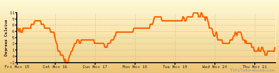
Temperature variation graph for the last seven days
Humidity Variation Graph

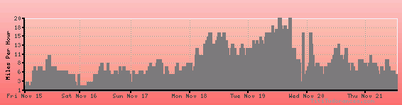
Wind speed
Weather Station: Nancy / Essey (latitude 48-41N, longitude 006-13E)
Local Time:
Nancy / Essey is in the "Europe/Paris" timezone.
The "Europe/Paris" timezone uses a Standard Time (ST) / Daylight Saving Time (DST) alternation scheme, and it currently is in ST (since Sunday, 27 October 2024, 02:00 AM local time). During ST, the timezone abbreviation is CET and the offset to Universal Time (UTC, GMT or Zulu) is +1:00 hours.
Nancy / Essey will exit standard time (entering DST) on Sunday, 30 March 2025, at 02:00 AM local time, when clocks will be turned forward 1 hour to Sunday, 30 March 2025, 03:00 AM local daylight time. During DST, the timezone abbreviation is CEST and the offset to UTC will be +2:00 hours.
Weather and Temperature in France
Popular Weather Searches:
 If you own or manage a travel-related business such as a hotel, a bed-and-breakfast, a restaurant, a pub or a cafeteria, you can create a web page for your business for free on Titi Tudorancea Travel Info. » |