| Published in Weather / Canada Weather Temperature |
Weather in Montreal, Canada
Current Conditions (Thursday, February 20, 2025 at 07:00 America/Montreal time)
Temperature: -0°F (-18°C) |
Forecast Overview
Fri Feb 21 
18°F -9°F -8°C -23°C Overcast skies.
detailsSat Feb 22 
21°F 1°F -6°C -17°C Partly cloudy skies.
detailsSun Feb 23 
28°F -6°F -2°C -21°C Chance of light snow in the morning and in the afternoon.
detailsMon Feb 24 
30°F 21°F -1°C -6°C Chance of light snow in the morning and late at night.
detailsTue Feb 25 
34°F 25°F 1°C -4°C Chance of snow all night and day.
detailsWed Feb 26 
36°F 32°F 2°C 0°C Chance of rain in the morning and in the afternoon. Chance of snow at various times.
detailsThu Feb 27 
34°F 16°F 1°C -9°C Chance of light snow in the afternoon.
detailsFri Feb 28 16°F -0°F -9°C -18°C Chance of snow after 7 pm.
detailsSat Mar 1 
23°F 3°F -5°C -16°C Chance of snow until 4 pm.
details
Detailed Forecast
| Friday, February 21 | sunrise: 06:49 sunset: 17:29 |
| Low around -9°F (-23°C), high around 18°F (-8°C). Estimated precipitation: 0 in (0.125 mm). Overcast skies. Wind: 8 mph (12 km/h). |
| Time | Skies | Conditions | Temp | Wind | Humidity | Soil Moisture |
| 01:00 04:00 | Considerable cloudiness. | -6°F (-21°C) | 5 mph (7 km/h) | 100% | 0.446% | |
| 04:00 07:00 | Overcast. | -9°F (-23°C) | 4 mph (7 km/h) | 100% | 0.446% | |
| 07:00 10:00 | Mostly cloudy. | 7°F (-14°C) | 5 mph (8 km/h) | 92% | 0.446% | |
| 10:00 13:00 | Overcast. | 16°F (-9°C) | 5 mph (8 km/h) | 86% | 0.446% | |
| 13:00 16:00 | Overcast. | 18°F (-8°C) | 6 mph (10 km/h) | 88% | 0.446% | |
| 16:00 19:00 | Considerable cloudiness. Precipitation: 0 in (0.125 mm). | 15°F (-9°C) | 8 mph (12 km/h) | 95% | 0.446% | |
| 19:00 22:00 | Overcast. | 13°F (-10°C) | 5 mph (8 km/h) | 94% | 0.446% | |
| 22:00 01:00 | Overcast. | 14°F (-10°C) | 6 mph (9 km/h) | 91% | 0.446% |
| Saturday, February 22 | sunrise: 06:47 sunset: 17:30 |
| Low around 1°F (-17°C), high around 20°F (-6°C). Partly cloudy skies. Wind: 13 mph (21 km/h). |
| Time | Skies | Conditions | Temp | Wind | Humidity | Soil Moisture |
| 01:00 04:00 | Overcast. | 13°F (-11°C) | 7 mph (11 km/h) | 91% | 0.447% | |
| 04:00 07:00 | Sunny. | 7°F (-14°C) | 7 mph (12 km/h) | 89% | 0.447% | |
| 07:00 10:00 | Mostly sunny. | 11°F (-11°C) | 9 mph (15 km/h) | 84% | 0.447% | |
| 10:00 13:00 | Overcast. | 18°F (-8°C) | 12 mph (19 km/h) | 80% | 0.447% | |
| 13:00 16:00 | Mostly cloudy. | 20°F (-7°C) | 13 mph (21 km/h) | 81% | 0.447% | |
| 16:00 19:00 | Clear. | 13°F (-10°C) | 9 mph (15 km/h) | 87% | 0.447% | |
| 19:00 22:00 | Clear. | 5°F (-15°C) | 7 mph (11 km/h) | 94% | 0.447% | |
| 22:00 01:00 | Overcast. | 1°F (-17°C) | 6 mph (10 km/h) | 99% | 0.447% |
| Sunday, February 23 | sunrise: 06:45 sunset: 17:31 |
| Low around -6°F (-21°C), high around 29°F (-2°C). Chance of light snow in the morning and early afternoon (between 10 am and 4 pm). Estimated precipitation: 0.04 in (1 mm). Mostly cloudy skies. Wind: 14 mph (23 km/h). |
| Time | Skies | Conditions | Temp | Wind | Humidity | Soil Moisture |
| 01:00 04:00 | Mostly cloudy. | -4°F (-20°C) | 5 mph (9 km/h) | 100% | 0.447% | |
| 04:00 07:00 | Mostly sunny. | -6°F (-21°C) | 5 mph (8 km/h) | 100% | 0.447% | |
| 07:00 10:00 | Overcast. | 13°F (-11°C) | 9 mph (14 km/h) | 91% | 0.447% | |
| 10:00 13:00 | Chance of light snow. Precipitation: 0 in (0.0625 mm). | 24°F (-4°C) | 11 mph (17 km/h) | 89% | 0.447% | |
| 13:00 16:00 | Chance of light snow. Precipitation: 0.02 in (0.5 mm). | 29°F (-2°C) | 10 mph (16 km/h) | 96% | 0.447% | |
| 16:00 19:00 | Partly cloudy. Precipitation: 0.02 in (0.4375 mm). | 26°F (-4°C) | 14 mph (23 km/h) | 84% | 0.447% | |
| 19:00 22:00 | Overcast. | 24°F (-5°C) | 13 mph (20 km/h) | 88% | 0.447% | |
| 22:00 01:00 | Overcast. | 24°F (-4°C) | 12 mph (20 km/h) | 88% | 0.447% |
| Monday, February 24 | sunrise: 06:44 sunset: 17:33 |
| Low around 21°F (-6°C), high around 31°F (-1°C). Chance of light snow in the morning (between 7 am and 1 pm) and at night (after 10 pm). Estimated precipitation: 0.03 in (0.75 mm). Overcast skies. Wind: 11 mph (18 km/h). |
| Time | Skies | Conditions | Temp | Wind | Humidity | Soil Moisture |
| 01:00 04:00 | Overcast. | 23°F (-5°C) | 11 mph (18 km/h) | 93% | 0.447% | |
| 04:00 07:00 | Considerable cloudiness. Precipitation: 0 in (0.125 mm). | 22°F (-6°C) | 9 mph (15 km/h) | 94% | 0.447% | |
| 07:00 10:00 | Chance of light snow. Precipitation: 0 in (0.0625 mm). | 26°F (-3°C) | 11 mph (17 km/h) | 92% | 0.447% | |
| 10:00 13:00 | Chance of light snow. Precipitation: 0 in (0.125 mm). | 30°F (-1°C) | 10 mph (17 km/h) | 88% | 0.447% | |
| 13:00 16:00 | Overcast. Precipitation: 0 in (0.125 mm). | 31°F (-1°C) | 8 mph (12 km/h) | 89% | 0.447% | |
| 16:00 19:00 | Overcast. Precipitation: 0 in (0.0625 mm). | 25°F (-4°C) | 4 mph (6 km/h) | 96% | 0.447% | |
| 19:00 22:00 | Overcast. | 22°F (-5°C) | 4 mph (7 km/h) | 97% | 0.447% | |
| 22:00 01:00 | Chance of light snow. Precipitation: 0.01 in (0.25 mm). | 25°F (-4°C) | 4 mph (6 km/h) | 97% | 0.447% |
| Tuesday, February 25 | sunrise: 06:42 sunset: 17:34 |
| Low around 25°F (-4°C), high around 33°F (1°C). Chance of snow all night and day. Estimated precipitation: 0.14 in (3.4375 mm). Overcast skies. Wind: 6 mph (9 km/h). |
| Time | Skies | Conditions | Temp | Wind | Humidity | Soil Moisture |
| 01:00 04:00 | Chance of snow. Precipitation: 0.04 in (1.125 mm). | 26°F (-3°C) | 4 mph (7 km/h) | 98% | 0.447% | |
| 04:00 07:00 | Chance of light snow. Precipitation: 0.02 in (0.5625 mm). | 27°F (-3°C) | 5 mph (8 km/h) | 98% | 0.447% | |
| 07:00 10:00 | Chance of light snow. Precipitation: 0.02 in (0.625 mm). | 31°F (-1°C) | 4 mph (7 km/h) | 100% | 0.449% | |
| 10:00 13:00 | Chance of light snow. Precipitation: 0.01 in (0.1875 mm). | 33°F (0°C) | 3 mph (5 km/h) | 100% | 0.45% | |
| 13:00 16:00 | Chance of light snow. Precipitation: 0.01 in (0.25 mm). | 33°F (0°C) | 5 mph (7 km/h) | 100% | 0.45% | |
| 16:00 19:00 | Chance of light snow. Precipitation: 0.01 in (0.25 mm). | 33°F (1°C) | 6 mph (9 km/h) | 100% | 0.45% | |
| 19:00 22:00 | Chance of light snow. Precipitation: 0.01 in (0.25 mm). | 32°F (0°C) | 3 mph (5 km/h) | 99% | 0.45% | |
| 22:00 01:00 | Chance of light snow. Precipitation: 0.01 in (0.1875 mm). | 32°F (0°C) | 4 mph (7 km/h) | 99% | 0.45% |
| Wednesday, February 26 | sunrise: 06:40 sunset: 17:36 |
| Low around 32°F (0°C), high around 36°F (2°C). Chance of rain from 10 am to 7 pm. Chance of snow early in the morning (before 4 am and from 7 am to 10 am) and in the evening (after 7 pm). Estimated precipitation: 0.43 in (10.875 mm). Overcast skies. Wind: 13 mph (21 km/h). |
| Time | Skies | Conditions | Temp | Wind | Humidity | Soil Moisture |
| 01:00 04:00 | Chance of light snow. Precipitation: 0.01 in (0.375 mm). | 32°F (0°C) | 6 mph (9 km/h) | 99% | 0.45% | |
| 04:00 07:00 | Overcast. Precipitation: 0.01 in (0.1875 mm). | 33°F (0°C) | 8 mph (13 km/h) | 99% | 0.45% | |
| 07:00 10:00 | Chance of light snow. Precipitation: 0 in (0.125 mm). | 34°F (1°C) | 11 mph (17 km/h) | 100% | 0.45% | |
| 10:00 13:00 | Chance of rain. Precipitation: 0.13 in (3.3125 mm). | 35°F (1°C) | 10 mph (17 km/h) | 100% | 0.45% | |
| 13:00 16:00 | Chance of rain. Precipitation: 0.11 in (2.8125 mm). | 34°F (1°C) | 9 mph (14 km/h) | 100% | 0.45% | |
| 16:00 19:00 | Chance of rain. Precipitation: 0.08 in (1.9375 mm). | 36°F (2°C) | 10 mph (16 km/h) | 100% | 0.45% | |
| 19:00 22:00 | Chance of snow. Precipitation: 0.06 in (1.5 mm). | 34°F (1°C) | 13 mph (21 km/h) | 99% | 0.45% | |
| 22:00 01:00 | Chance of light snow. Precipitation: 0.02 in (0.625 mm). | 33°F (1°C) | 13 mph (20 km/h) | 98% | 0.45% |
| Thursday, February 27 | sunrise: 06:39 sunset: 17:37 |
| Low around 16°F (-9°C), high around 34°F (1°C). Chance of light snow early in the afternoon (between 1 pm and 4 pm). Estimated precipitation: 0.02 in (0.5625 mm). Mostly cloudy skies. Wind: 13 mph (21 km/h). |
| Time | Skies | Conditions | Temp | Wind | Humidity | Soil Moisture |
| 01:00 04:00 | Overcast. Precipitation: 0 in (0.0625 mm). | 34°F (1°C) | 12 mph (19 km/h) | 88% | 0.45% | |
| 04:00 07:00 | More sun than clouds. | 31°F (-1°C) | 12 mph (20 km/h) | 87% | 0.45% | |
| 07:00 10:00 | Overcast. | 32°F (0°C) | 13 mph (21 km/h) | 87% | 0.45% | |
| 10:00 13:00 | Overcast. Precipitation: 0 in (0.0625 mm). | 33°F (0°C) | 12 mph (19 km/h) | 91% | 0.45% | |
| 13:00 16:00 | Chance of light snow. Precipitation: 0 in (0.125 mm). | 33°F (1°C) | 10 mph (16 km/h) | 95% | 0.45% | |
| 16:00 19:00 | Partly cloudy. Precipitation: 0.01 in (0.3125 mm). | 31°F (-1°C) | 9 mph (15 km/h) | 84% | 0.45% | |
| 19:00 22:00 | Overcast. | 21°F (-6°C) | 8 mph (13 km/h) | 84% | 0.45% | |
| 22:00 01:00 | Overcast. | 16°F (-9°C) | 5 mph (8 km/h) | 88% | 0.45% |
| Friday, February 28 | sunrise: 06:37 sunset: 17:39 |
| Low around -0°F (-18°C), high around 16°F (-9°C). Chance of snow in the evening and during the night (after 7 pm). Estimated precipitation: 0.05 in (1.25 mm). Mostly cloudy skies. Wind: 14 mph (23 km/h). |
| Time | Skies | Conditions | Temp | Wind | Humidity | Soil Moisture |
| 01:00 04:00 | Overcast. | 5°F (-15°C) | 5 mph (7 km/h) | 87% | 0.45% | |
| 04:00 07:00 | Sunny. | -0°F (-18°C) | 6 mph (10 km/h) | 83% | 0.45% | |
| 07:00 10:00 | Sunny. | 4°F (-15°C) | 6 mph (9 km/h) | 75% | 0.45% | |
| 10:00 13:00 | Overcast. | 9°F (-13°C) | 6 mph (10 km/h) | 76% | 0.45% | |
| 13:00 16:00 | Overcast. | 9°F (-13°C) | 8 mph (13 km/h) | 77% | 0.45% | |
| 16:00 19:00 | Overcast. | 7°F (-14°C) | 9 mph (15 km/h) | 86% | 0.45% | |
| 19:00 22:00 | Chance of light snow. Precipitation: 0.01 in (0.1875 mm). | 8°F (-13°C) | 11 mph (17 km/h) | 89% | 0.45% | |
| 22:00 01:00 | Chance of snow. Precipitation: 0.04 in (1.0625 mm). | 9°F (-13°C) | 14 mph (23 km/h) | 94% | 0.45% |
| Saturday, March 1 | sunrise: 06:35 sunset: 17:40 |
| Low around 4°F (-16°C), high around 24°F (-5°C). Chance of snow until late afternoon (4 pm). Estimated precipitation: 0.2 in (5 mm). Mostly cloudy skies. Wind: 15 mph (24 km/h). |
| Time | Skies | Conditions | Temp | Wind | Humidity | Soil Moisture |
| 01:00 04:00 | Chance of snow. Precipitation: 0.05 in (1.375 mm). | 9°F (-13°C) | 15 mph (24 km/h) | 93% | 0.45% | |
| 04:00 07:00 | Chance of snow. Precipitation: 0.08 in (2.0625 mm). | 11°F (-12°C) | 14 mph (22 km/h) | 93% | 0.45% | |
| 07:00 10:00 | Chance of snow. Precipitation: 0.04 in (1.0625 mm). | 15°F (-10°C) | 11 mph (17 km/h) | 93% | 0.45% | |
| 10:00 13:00 | Chance of light snow. Precipitation: 0.01 in (0.25 mm). | 21°F (-6°C) | 4 mph (7 km/h) | 86% | 0.45% | |
| 13:00 16:00 | Chance of light snow. Precipitation: 0.01 in (0.25 mm). | 23°F (-5°C) | 9 mph (15 km/h) | 89% | 0.45% | |
| 16:00 19:00 | Clear. | 15°F (-9°C) | 8 mph (13 km/h) | 88% | 0.45% | |
| 19:00 22:00 | Clear. | 7°F (-14°C) | 6 mph (9 km/h) | 96% | 0.45% | |
| 22:00 01:00 | Overcast. | 4°F (-16°C) | 4 mph (7 km/h) | 96% | 0.45% |
Climate Chart
Places with a similar climate: Fort Drum (NY, US), Oshkosh (WI, US), Highgate City, Franklin County (VT, US), Massena (NY, US), Appleton / Outagamie (WI, US), Burlington (VT, US), Fond Du Lac County (WI, US), Sheboygan County (WI, US), Manitowoc County (WI, US), Green Bay (WI, US), Madison, Dane County (WI, US), West Bend (WI, US), Sturgeon Bay (WI, US), Plattsburgh (NY, US), Dubuque (IA, US), Toronto, Ontario, Menominee / Marinette County (MI, US), Traverse City (MI, US), Augusta (ME, US), Barre / Montpelier (VT, US), Preston, Fillmore County (MN, US), Watertown (NY, US), Mineral Point, Iowa County (WI, US), Saint Johnsbury (VT, US), Waukesha City/County (WI, US).
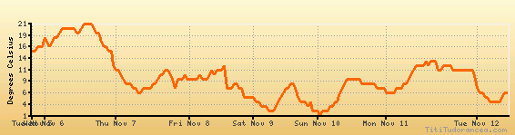
Temperature variation graph for the last seven days
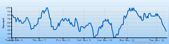
Humidity Variation Graph
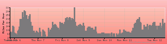
Wind speed
Weather Station: Montreal / Pierre Elliot Trudeau International Airport, Que (latitude 45-28N, longitude 073-45W)
Local Time:
Montreal is in the "America/Montreal" timezone.
The "America/Montreal" timezone uses a Standard Time (ST) / Daylight Saving Time (DST) alternation scheme, and it currently is in ST (since Sunday, 3 November 2024, 01:00 AM local time). During ST, the timezone abbreviation is EST and the offset to Universal Time (UTC, GMT or Zulu) is -5:00 hours.
Montreal will exit standard time (entering DST) on Sunday, 9 March 2025, at 02:00 AM local time, when clocks will be turned forward 1 hour to Sunday, 9 March 2025, 03:00 AM local daylight time. During DST, the timezone abbreviation is EDT and the offset to UTC will be -4:00 hours.
Weather and Temperature in Canada
Popular Weather Searches:
 If you own or manage a travel-related business such as a hotel, a bed-and-breakfast, a restaurant, a pub or a cafeteria, you can create a web page for your business for free on Titi Tudorancea Travel Info. » |