| Published in Weather / Kentucky Weather Temperature |
Weather in Monticello, Wayne County, Kentucky
Current Conditions (Sunday, February 16, 2025 at 21:56 America/Kentucky/Monticello time)
Temperature: 28°F (-2°C) |
Forecast Overview
Mon Feb 17 
34°F 19°F 1°C -7°C Mostly cloudy skies.
detailsTue Feb 18 37°F 23°F 3°C -5°C Overcast skies.
detailsWed Feb 19 
30°F 18°F -1°C -8°C Chance of snow all night and day.
detailsThu Feb 20 
23°F 9°F -5°C -13°C Chance of light snow in the morning.
detailsFri Feb 21 
30°F 7°F -1°C -14°C More sun than clouds.
detailsSat Feb 22 36°F 12°F 2°C -11°C More sun than clouds.
detailsSun Feb 23 46°F 19°F 8°C -7°C Chance of light rain late at night.
detailsMon Feb 24 
36°F 32°F 2°C -0°C Chance of rain in the afternoon. Chance of snow before sunrise.
detailsTue Feb 25 37°F 30°F 3°C -1°C Chance of light snow at various times.
details
Detailed Forecast
| Monday, February 17 | sunrise: 07:27 sunset: 18:20 |
| Low around 20°F (-7°C), high around 34°F (1°C). Estimated precipitation: 0 in (0.125 mm). Mostly cloudy skies. Wind: 9 mph (14 km/h). |
| Time | Skies | Conditions | Temp | Wind | Humidity | Soil Moisture |
| 01:00 04:00 | Overcast. Precipitation: 0 in (0.125 mm). | 22°F (-6°C) | 9 mph (14 km/h) | 82% | 0.338% | |
| 04:00 07:00 | Overcast. | 20°F (-7°C) | 6 mph (10 km/h) | 78% | 0.34% | |
| 07:00 10:00 | Mostly sunny, with a few passing clouds. | 24°F (-4°C) | 6 mph (9 km/h) | 60% | 0.343% | |
| 10:00 13:00 | Overcast. | 32°F (0°C) | 7 mph (11 km/h) | 44% | 0.344% | |
| 13:00 16:00 | Overcast. | 34°F (1°C) | 5 mph (8 km/h) | 42% | 0.345% | |
| 16:00 19:00 | Clear. | 27°F (-3°C) | 4 mph (7 km/h) | 63% | 0.347% | |
| 19:00 22:00 | Partly cloudy. | 25°F (-4°C) | 3 mph (4 km/h) | 72% | 0.349% | |
| 22:00 01:00 | Overcast. | 24°F (-4°C) | 4 mph (7 km/h) | 80% | 0.351% |
| Tuesday, February 18 | sunrise: 07:25 sunset: 18:21 |
| Low around 24°F (-5°C), high around 37°F (3°C). Estimated precipitation: 0 in (0.125 mm). Overcast skies. Wind: 9 mph (15 km/h). |
| Time | Skies | Conditions | Temp | Wind | Humidity | Soil Moisture |
| 01:00 04:00 | Overcast. | 24°F (-4°C) | 5 mph (9 km/h) | 77% | 0.354% | |
| 04:00 07:00 | Overcast. | 24°F (-4°C) | 7 mph (11 km/h) | 73% | 0.356% | |
| 07:00 10:00 | Overcast. | 28°F (-2°C) | 7 mph (11 km/h) | 62% | 0.358% | |
| 10:00 13:00 | More sun than clouds. | 34°F (1°C) | 7 mph (11 km/h) | 51% | 0.36% | |
| 13:00 16:00 | Mostly cloudy. | 36°F (2°C) | 8 mph (13 km/h) | 53% | 0.36% | |
| 16:00 19:00 | Overcast. | 28°F (-2°C) | 8 mph (13 km/h) | 71% | 0.36% | |
| 19:00 22:00 | Overcast. | 26°F (-4°C) | 9 mph (15 km/h) | 80% | 0.361% | |
| 22:00 01:00 | Overcast. Precipitation: 0 in (0.125 mm). | 25°F (-4°C) | 9 mph (14 km/h) | 84% | 0.362% |
| Wednesday, February 19 | sunrise: 07:24 sunset: 18:22 |
| Low around 18°F (-8°C), high around 30°F (-1°C). Chance of snow all night and day. Estimated precipitation: 0.39 in (9.9375 mm). Overcast skies. Wind: 8 mph (12 km/h). |
| Time | Skies | Conditions | Temp | Wind | Humidity | Soil Moisture |
| 01:00 04:00 | Chance of snow. Precipitation: 0.04 in (1.125 mm). | 24°F (-4°C) | 6 mph (10 km/h) | 91% | 0.363% | |
| 04:00 07:00 | Chance of snow. Precipitation: 0.14 in (3.625 mm). | 24°F (-5°C) | 5 mph (8 km/h) | 95% | 0.364% | |
| 07:00 10:00 | Chance of snow. Precipitation: 0.12 in (3.0625 mm). | 24°F (-5°C) | 6 mph (10 km/h) | 92% | 0.366% | |
| 10:00 13:00 | Chance of light snow. Precipitation: 0.03 in (0.875 mm). | 30°F (-1°C) | 5 mph (8 km/h) | 87% | 0.368% | |
| 13:00 16:00 | Chance of light snow. Precipitation: 0.01 in (0.3125 mm). | 29°F (-2°C) | 8 mph (12 km/h) | 86% | 0.371% | |
| 16:00 19:00 | Chance of light snow. Precipitation: 0.01 in (0.3125 mm). | 23°F (-5°C) | 7 mph (10 km/h) | 96% | 0.372% | |
| 19:00 22:00 | Chance of light snow. Precipitation: 0.01 in (0.25 mm). | 19°F (-7°C) | 3 mph (5 km/h) | 98% | 0.373% | |
| 22:00 01:00 | Chance of light snow. Precipitation: 0.01 in (0.375 mm). | 18°F (-8°C) | 6 mph (10 km/h) | 95% | 0.374% |
| Thursday, February 20 | sunrise: 07:23 sunset: 18:23 |
| Low around 9°F (-13°C), high around 23°F (-5°C). Chance of light snow early in the morning (until 10 am). Estimated precipitation: 0.03 in (0.6875 mm). Mostly cloudy skies. Wind: 8 mph (14 km/h). |
| Time | Skies | Conditions | Temp | Wind | Humidity | Soil Moisture |
| 01:00 04:00 | Chance of light snow. Precipitation: 0.01 in (0.1875 mm). | 16°F (-9°C) | 7 mph (11 km/h) | 96% | 0.376% | |
| 04:00 07:00 | Chance of light snow. Precipitation: 0 in (0.125 mm). | 14°F (-10°C) | 6 mph (9 km/h) | 95% | 0.377% | |
| 07:00 10:00 | Chance of light snow. Precipitation: 0 in (0.125 mm). | 17°F (-9°C) | 8 mph (12 km/h) | 82% | 0.379% | |
| 10:00 13:00 | Overcast. Precipitation: 0 in (0.125 mm). | 22°F (-6°C) | 8 mph (14 km/h) | 69% | 0.38% | |
| 13:00 16:00 | Overcast. Precipitation: 0 in (0.0625 mm). | 23°F (-5°C) | 8 mph (13 km/h) | 68% | 0.381% | |
| 16:00 19:00 | Partly cloudy. Precipitation: 0 in (0.0625 mm). | 15°F (-10°C) | 3 mph (5 km/h) | 96% | 0.383% | |
| 19:00 22:00 | Considerable cloudiness. | 10°F (-12°C) | 1 mph (2 km/h) | 99% | 0.385% | |
| 22:00 01:00 | Considerable cloudiness. | 9°F (-13°C) | 1 mph (2 km/h) | 99% | 0.387% |
| Friday, February 21 | sunrise: 07:22 sunset: 18:24 |
| Low around 8°F (-14°C), high around 30°F (-1°C). More sun than clouds. Wind: 6 mph (10 km/h). |
| Time | Skies | Conditions | Temp | Wind | Humidity | Soil Moisture |
| 01:00 04:00 | Considerable cloudiness. | 8°F (-13°C) | 2 mph (3 km/h) | 99% | 0.39% | |
| 04:00 07:00 | Partly cloudy. | 8°F (-13°C) | 2 mph (2 km/h) | 98% | 0.392% | |
| 07:00 10:00 | Sunny. | 20°F (-7°C) | 4 mph (7 km/h) | 73% | 0.395% | |
| 10:00 13:00 | Mostly sunny. | 28°F (-2°C) | 4 mph (7 km/h) | 63% | 0.398% | |
| 13:00 16:00 | Overcast. | 29°F (-2°C) | 6 mph (10 km/h) | 67% | 0.402% | |
| 16:00 19:00 | Clear. | 18°F (-8°C) | 3 mph (5 km/h) | 96% | 0.403% | |
| 19:00 22:00 | Overcast. | 16°F (-9°C) | 2 mph (2 km/h) | 98% | 0.405% | |
| 22:00 01:00 | Partly cloudy. | 14°F (-10°C) | 1 mph (1 km/h) | 99% | 0.408% |
| Saturday, February 22 | sunrise: 07:21 sunset: 18:25 |
| Low around 12°F (-11°C), high around 36°F (2°C). More sun than clouds. Wind: 4 mph (6 km/h). |
| Time | Skies | Conditions | Temp | Wind | Humidity | Soil Moisture |
| 01:00 04:00 | Considerable cloudiness. | 13°F (-11°C) | 0 mph (1 km/h) | 99% | 0.41% | |
| 04:00 07:00 | Mostly cloudy. | 12°F (-11°C) | 2 mph (3 km/h) | 99% | 0.412% | |
| 07:00 10:00 | More sun than clouds. | 25°F (-4°C) | 3 mph (5 km/h) | 78% | 0.414% | |
| 10:00 13:00 | Sunny. | 34°F (1°C) | 4 mph (6 km/h) | 63% | 0.42% | |
| 13:00 16:00 | Sunny. | 36°F (2°C) | 2 mph (4 km/h) | 65% | 0.426% | |
| 16:00 19:00 | Clear. | 23°F (-5°C) | 3 mph (4 km/h) | 97% | 0.427% | |
| 19:00 22:00 | Mostly clear, with a few passing clouds. | 20°F (-7°C) | 1 mph (2 km/h) | 98% | 0.428% | |
| 22:00 01:00 | Overcast. | 19°F (-7°C) | 2 mph (3 km/h) | 99% | 0.43% |
| Sunday, February 23 | sunrise: 07:19 sunset: 18:26 |
| Low around 19°F (-7°C), high around 46°F (8°C). Chance of light rain late at night (after 10 pm). Estimated precipitation: 0 in (0.0625 mm). Mostly cloudy skies. Wind: 5 mph (8 km/h). |
| Time | Skies | Conditions | Temp | Wind | Humidity | Soil Moisture |
| 01:00 04:00 | Considerable cloudiness. | 19°F (-7°C) | 2 mph (3 km/h) | 99% | 0.432% | |
| 04:00 07:00 | Partly cloudy. | 19°F (-7°C) | 3 mph (4 km/h) | 98% | 0.434% | |
| 07:00 10:00 | Sunny. | 36°F (2°C) | 3 mph (5 km/h) | 71% | 0.436% | |
| 10:00 13:00 | Overcast. | 45°F (7°C) | 5 mph (8 km/h) | 61% | 0.439% | |
| 13:00 16:00 | Overcast. | 45°F (7°C) | 4 mph (7 km/h) | 72% | 0.441% | |
| 16:00 19:00 | Overcast. | 34°F (1°C) | 3 mph (4 km/h) | 95% | 0.44% | |
| 19:00 22:00 | Overcast. | 31°F (-1°C) | 3 mph (4 km/h) | 96% | 0.439% | |
| 22:00 01:00 | Chance of light rain. Precipitation: 0 in (0.0625 mm). | 33°F (0°C) | 1 mph (2 km/h) | 94% | 0.438% |
| Monday, February 24 | sunrise: 07:18 sunset: 18:27 |
| Low around 32°F (-0°C), high around 36°F (2°C). Chance of rain late in the afternoon (between 4 pm and 7 pm). Chance of snow before sunrise (from 1 am to 7 am). Estimated precipitation: 0.1 in (2.625 mm). Overcast skies. Wind: 7 mph (11 km/h). |
| Time | Skies | Conditions | Temp | Wind | Humidity | Soil Moisture |
| 01:00 04:00 | Chance of snow. Precipitation: 0.06 in (1.5 mm). | 33°F (0°C) | 1 mph (2 km/h) | 100% | 0.441% | |
| 04:00 07:00 | Chance of light snow. Precipitation: 0.02 in (0.4375 mm). | 33°F (0°C) | 1 mph (1 km/h) | 100% | 0.44% | |
| 07:00 10:00 | Overcast. | 35°F (1°C) | 1 mph (2 km/h) | 100% | 0.439% | |
| 10:00 13:00 | Overcast. Precipitation: 0 in (0.0625 mm). | 36°F (2°C) | 2 mph (3 km/h) | 99% | 0.437% | |
| 13:00 16:00 | Overcast. Precipitation: 0.02 in (0.4375 mm). | 35°F (2°C) | 6 mph (9 km/h) | 99% | 0.438% | |
| 16:00 19:00 | Chance of light rain. Precipitation: 0 in (0.0625 mm). | 33°F (0°C) | 7 mph (11 km/h) | 93% | 0.432% | |
| 19:00 22:00 | Overcast. Precipitation: 0 in (0.0625 mm). | 32°F (-0°C) | 2 mph (3 km/h) | 97% | 0.426% | |
| 22:00 01:00 | Overcast. Precipitation: 0 in (0.0625 mm). | 32°F (-0°C) | 4 mph (7 km/h) | 95% | 0.422% |
| Tuesday, February 25 | sunrise: 07:17 sunset: 18:28 |
| Low around 31°F (-1°C), high around 37°F (3°C). Chance of light snow all night and all morning (until 1 pm) and again late in the afternoon (between 4 pm and 7 pm). Estimated precipitation: 0.06 in (1.5 mm). Overcast skies. Wind: 10 mph (15 km/h). |
| Time | Skies | Conditions | Temp | Wind | Humidity | Soil Moisture |
| 01:00 04:00 | Chance of light snow. Precipitation: 0 in (0.0625 mm). | 31°F (-1°C) | 3 mph (5 km/h) | 98% | 0.417% | |
| 04:00 07:00 | Chance of light snow. Precipitation: 0 in (0.125 mm). | 31°F (-0°C) | 4 mph (7 km/h) | 98% | 0.414% | |
| 07:00 10:00 | Chance of light snow. Precipitation: 0.01 in (0.1875 mm). | 32°F (0°C) | 6 mph (9 km/h) | 96% | 0.411% | |
| 10:00 13:00 | Chance of light snow. Precipitation: 0.02 in (0.5625 mm). | 35°F (2°C) | 7 mph (12 km/h) | 98% | 0.409% | |
| 13:00 16:00 | Overcast. Precipitation: 0.01 in (0.3125 mm). | 36°F (2°C) | 10 mph (15 km/h) | 92% | 0.406% | |
| 16:00 19:00 | Chance of light snow. Precipitation: 0.01 in (0.1875 mm). | 34°F (1°C) | 8 mph (13 km/h) | 97% | 0.401% | |
| 19:00 22:00 | Overcast. Precipitation: 0 in (0.0625 mm). | 33°F (1°C) | 6 mph (10 km/h) | 95% | 0.394% | |
| 22:00 01:00 | Overcast. | 32°F (-0°C) | 4 mph (7 km/h) | 98% | 0.389% |
Climate Chart
» Monticello, Wayne County Climate Chart
Places with a similar climate: Point Pleasant, Mason County (WV), Staunton / Shenandoah (VA), Bristol / Johnson / Kingsport (TN), Pineville (WV), Warrenton City, Fauquier County (VA), Cincinnati (OH), Orange County (VA), Blacksburg, Virginia Tech (VA), Culpeper County (VA), Danville City, Boyle County (KY), Manassas (VA), Dublin / New River Valley (VA), London (KY), Frankfort (KY), Fort Meade / Tipton (MD), Charleston (WV), Middletown City, Butler County (OH), Lynchburg (VA), Huntington (WV), Stafford (VA), Petersburg, Grant County (WV), Frederick (MD), Abingdon (VA), Mount Vernon (IL), Charlottesville-Albemarle (VA).
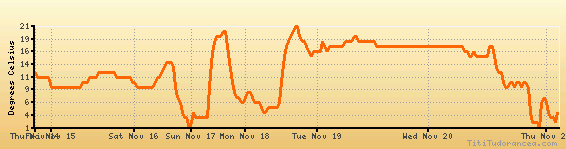
Temperature variation graph for the last seven days
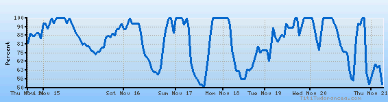
Humidity Variation Graph
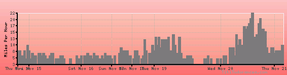
Wind speed
Weather Station: Monticello, Wayne County Airport (latitude 36-51-19N, longitude 084-51-22W)
Local Time:
Monticello, Wayne County is in the "America/Kentucky/Monticello" timezone.
The "America/Kentucky/Monticello" timezone uses a Standard Time (ST) / Daylight Saving Time (DST) alternation scheme, and it currently is in ST (since Sunday, 3 November 2024, 01:00 AM local time). During ST, the timezone abbreviation is EST and the offset to Universal Time (UTC, GMT or Zulu) is -5:00 hours.
Monticello, Wayne County will exit standard time (entering DST) on Sunday, 9 March 2025, at 02:00 AM local time, when clocks will be turned forward 1 hour to Sunday, 9 March 2025, 03:00 AM local daylight time. During DST, the timezone abbreviation is EDT and the offset to UTC will be -4:00 hours.
Weather and Temperature in Kentucky
Popular Weather Searches:
 If you own or manage a travel-related business such as a hotel, a bed-and-breakfast, a restaurant, a pub or a cafeteria, you can create a web page for your business for free on Titi Tudorancea Travel Info. » |