| Published in Weather / Wisconsin Weather Temperature |
Weather in Monroe, Wisconsin
Current Conditions (Thursday, March 13, 2025 at 12:55 America/Chicago time)
Temperature: 61°F (16°C) |
Forecast Overview
Fri Mar 14 
63°F 37°F 17°C 3°C Mostly sunny, with a few passing clouds.
detailsSat Mar 15 
73°F 41°F 23°C 5°C Chance of heavy rain after 7 pm.
detailsSun Mar 16 
55°F 30°F 13°C -1°C Overcast skies.
detailsMon Mar 17 43°F 28°F 6°C -2°C Mostly cloudy skies.
detailsTue Mar 18 
52°F 28°F 11°C -2°C Mostly cloudy skies.
detailsWed Mar 19 66°F 39°F 19°C 4°C Considerable cloudiness.
detailsThu Mar 20 
59°F 28°F 15°C -2°C Chance of rain before sunrise. Chance of snow in the morning.
detailsFri Mar 21 50°F 27°F 10°C -3°C Chance of light rain late at night.
detailsSat Mar 22 
39°F 25°F 4°C -4°C Chance of rain/snow before sunrise.
details
Detailed Forecast
| Friday, March 14 | sunrise: 07:14 sunset: 19:02 |
| Low around 37°F (3°C), high around 62°F (17°C). Mostly sunny, with a few passing clouds. Wind: 10 mph (17 km/h). |
| Time | Skies | Conditions | Temp | Wind | Humidity | Soil Moisture |
| 01:00 04:00 | Clear. | 38°F (4°C) | 5 mph (9 km/h) | 62% | 0.286% | |
| 04:00 07:00 | Mostly clear, with a few passing clouds. | 38°F (3°C) | 5 mph (8 km/h) | 64% | 0.286% | |
| 07:00 10:00 | Sunny. | 48°F (9°C) | 7 mph (11 km/h) | 50% | 0.286% | |
| 10:00 13:00 | Mostly sunny, with a few passing clouds. | 58°F (15°C) | 9 mph (15 km/h) | 37% | 0.282% | |
| 13:00 16:00 | Sunny. | 62°F (17°C) | 10 mph (16 km/h) | 37% | 0.278% | |
| 16:00 19:00 | Sunny. | 54°F (12°C) | 9 mph (14 km/h) | 59% | 0.277% | |
| 19:00 22:00 | Partly cloudy. | 48°F (9°C) | 10 mph (15 km/h) | 62% | 0.277% | |
| 22:00 01:00 | Partly cloudy. | 48°F (9°C) | 10 mph (17 km/h) | 73% | 0.278% |
| Saturday, March 15 | sunrise: 07:12 sunset: 19:03 |
| Low around 42°F (5°C), high around 73°F (23°C). Chance of heavy rain in the evening (between 7 pm and 10 pm). Estimated precipitation: 0.74 in (18.75 mm). Mostly cloudy skies. Wind: 28 mph (45 km/h). |
| Time | Skies | Conditions | Temp | Wind | Humidity | Soil Moisture |
| 01:00 04:00 | Overcast. Precipitation: 0.01 in (0.25 mm). | 51°F (11°C) | 12 mph (20 km/h) | 91% | 0.28% | |
| 04:00 07:00 | Overcast. | 54°F (12°C) | 13 mph (21 km/h) | 92% | 0.281% | |
| 07:00 10:00 | Sunny. | 61°F (16°C) | 19 mph (31 km/h) | 79% | 0.282% | |
| 10:00 13:00 | Overcast. | 70°F (21°C) | 23 mph (36 km/h) | 55% | 0.278% | |
| 13:00 16:00 | Overcast. | 73°F (23°C) | 21 mph (34 km/h) | 49% | 0.273% | |
| 16:00 19:00 | Overcast. | 68°F (20°C) | 23 mph (36 km/h) | 56% | 0.271% | |
| 19:00 22:00 | Chance of rain. Precipitation: 0.05 in (1.1875 mm). | 65°F (18°C) | 28 mph (45 km/h) | 68% | 0.276% | |
| 22:00 01:00 | Clear. Precipitation: 0.68 in (17.3125 mm). | 50°F (10°C) | 11 mph (17 km/h) | 83% | 0.39% |
| Sunday, March 16 | sunrise: 07:10 sunset: 19:04 |
| Low around 29°F (-1°C), high around 55°F (13°C). Overcast skies. Wind: 28 mph (44 km/h). |
| Time | Skies | Conditions | Temp | Wind | Humidity | Soil Moisture |
| 01:00 04:00 | Considerable cloudiness. | 54°F (12°C) | 22 mph (35 km/h) | 56% | 0.372% | |
| 04:00 07:00 | Overcast. | 53°F (12°C) | 28 mph (44 km/h) | 50% | 0.359% | |
| 07:00 10:00 | Overcast. | 52°F (11°C) | 28 mph (44 km/h) | 73% | 0.349% | |
| 10:00 13:00 | Overcast. | 52°F (11°C) | 24 mph (38 km/h) | 70% | 0.34% | |
| 13:00 16:00 | Overcast. | 49°F (9°C) | 18 mph (28 km/h) | 74% | 0.334% | |
| 16:00 19:00 | Overcast. | 43°F (6°C) | 14 mph (23 km/h) | 73% | 0.331% | |
| 19:00 22:00 | Considerable cloudiness. | 36°F (2°C) | 16 mph (26 km/h) | 75% | 0.327% | |
| 22:00 01:00 | Mostly cloudy. | 29°F (-1°C) | 17 mph (28 km/h) | 74% | 0.324% |
| Monday, March 17 | sunrise: 07:09 sunset: 19:05 |
| Low around 28°F (-2°C), high around 42°F (6°C). Mostly cloudy skies. Wind: 18 mph (30 km/h). |
| Time | Skies | Conditions | Temp | Wind | Humidity | Soil Moisture |
| 01:00 04:00 | Times of clear skies and clouds. | 29°F (-2°C) | 17 mph (27 km/h) | 70% | 0.323% | |
| 04:00 07:00 | Overcast. | 28°F (-2°C) | 14 mph (23 km/h) | 63% | 0.323% | |
| 07:00 10:00 | Overcast. | 31°F (-0°C) | 18 mph (29 km/h) | 46% | 0.322% | |
| 10:00 13:00 | Sunny. | 39°F (4°C) | 18 mph (30 km/h) | 36% | 0.319% | |
| 13:00 16:00 | Sunny. | 42°F (6°C) | 18 mph (29 km/h) | 34% | 0.314% | |
| 16:00 19:00 | Overcast. | 38°F (3°C) | 12 mph (19 km/h) | 46% | 0.31% | |
| 19:00 22:00 | Considerable cloudiness. | 35°F (2°C) | 11 mph (18 km/h) | 57% | 0.308% | |
| 22:00 01:00 | Overcast. | 29°F (-1°C) | 5 mph (9 km/h) | 76% | 0.307% |
| Tuesday, March 18 | sunrise: 07:07 sunset: 19:06 |
| Low around 29°F (-2°C), high around 51°F (11°C). Estimated precipitation: 0 in (0.125 mm). Mostly cloudy skies. Wind: 9 mph (14 km/h). |
| Time | Skies | Conditions | Temp | Wind | Humidity | Soil Moisture |
| 01:00 04:00 | Overcast. | 30°F (-1°C) | 1 mph (2 km/h) | 69% | 0.308% | |
| 04:00 07:00 | Overcast. Precipitation: 0 in (0.125 mm). | 31°F (-0°C) | 5 mph (9 km/h) | 63% | 0.308% | |
| 07:00 10:00 | Sunny. | 38°F (3°C) | 7 mph (11 km/h) | 50% | 0.308% | |
| 10:00 13:00 | Overcast. | 46°F (8°C) | 9 mph (14 km/h) | 46% | 0.305% | |
| 13:00 16:00 | Sunny. | 51°F (11°C) | 7 mph (10 km/h) | 47% | 0.301% | |
| 16:00 19:00 | Sunny. | 46°F (8°C) | 5 mph (7 km/h) | 64% | 0.299% | |
| 19:00 22:00 | Overcast. | 42°F (6°C) | 7 mph (12 km/h) | 73% | 0.299% | |
| 22:00 01:00 | Overcast. | 40°F (4°C) | 8 mph (13 km/h) | 76% | 0.298% |
| Wednesday, March 19 | sunrise: 07:05 sunset: 19:08 |
| Low around 40°F (4°C), high around 67°F (19°C). Considerable cloudiness. Wind: 22 mph (35 km/h). |
| Time | Skies | Conditions | Temp | Wind | Humidity | Soil Moisture |
| 01:00 04:00 | Mostly clear, with a few passing clouds. | 40°F (5°C) | 8 mph (14 km/h) | 82% | 0.298% | |
| 04:00 07:00 | Overcast. | 44°F (7°C) | 11 mph (17 km/h) | 91% | 0.298% | |
| 07:00 10:00 | Overcast. | 53°F (12°C) | 16 mph (26 km/h) | 76% | 0.297% | |
| 10:00 13:00 | Overcast. | 63°F (17°C) | 22 mph (35 km/h) | 57% | 0.293% | |
| 13:00 16:00 | Overcast. | 67°F (19°C) | 21 mph (33 km/h) | 54% | 0.288% | |
| 16:00 19:00 | Overcast. | 62°F (17°C) | 21 mph (34 km/h) | 56% | 0.286% | |
| 19:00 22:00 | Clear. | 61°F (16°C) | 20 mph (33 km/h) | 62% | 0.285% | |
| 22:00 01:00 | Clear. | 58°F (15°C) | 17 mph (28 km/h) | 71% | 0.284% |
| Thursday, March 20 | sunrise: 07:03 sunset: 19:09 |
| Low around 28°F (-2°C), high around 59°F (15°C). Chance of rain before sunrise (between 4 am and 7 am). Chance of snow in the morning (between 7 am and 1 pm). The precipitation may fall as scattered showers of varying intensity. Estimated precipitation: 0.28 in (7.125 mm). Mostly cloudy skies. Wind: 27 mph (43 km/h). |
| Time | Skies | Conditions | Temp | Wind | Humidity | Soil Moisture |
| 01:00 04:00 | Overcast. Precipitation: 0.03 in (0.6875 mm). | 59°F (15°C) | 19 mph (31 km/h) | 79% | 0.288% | |
| 04:00 07:00 | Chance of scattered rain showers. Precipitation: 0.11 in (2.875 mm). | 44°F (7°C) | 19 mph (30 km/h) | 93% | 0.312% | |
| 07:00 10:00 | Chance of snow. Precipitation: 0.04 in (1.0625 mm). | 31°F (-1°C) | 27 mph (43 km/h) | 85% | 0.321% | |
| 10:00 13:00 | Chance of snow. Precipitation: 0.07 in (1.8125 mm). | 30°F (-1°C) | 21 mph (35 km/h) | 92% | 0.319% | |
| 13:00 16:00 | Overcast. Precipitation: 0.03 in (0.6875 mm). | 33°F (1°C) | 19 mph (30 km/h) | 73% | 0.32% | |
| 16:00 19:00 | Overcast. | 32°F (-0°C) | 17 mph (27 km/h) | 76% | 0.319% | |
| 19:00 22:00 | Overcast. | 29°F (-2°C) | 11 mph (18 km/h) | 82% | 0.318% | |
| 22:00 01:00 | Clear. | 28°F (-2°C) | 10 mph (15 km/h) | 84% | 0.318% |
| Friday, March 21 | sunrise: 07:02 sunset: 19:10 |
| Low around 27°F (-3°C), high around 50°F (10°C). Chance of light rain late at night (after 10 pm). Estimated precipitation: 0.01 in (0.375 mm). Partly cloudy skies. Wind: 17 mph (28 km/h). |
| Time | Skies | Conditions | Temp | Wind | Humidity | Soil Moisture |
| 01:00 04:00 | Clear. | 28°F (-2°C) | 10 mph (16 km/h) | 87% | 0.319% | |
| 04:00 07:00 | Clear. | 28°F (-2°C) | 13 mph (21 km/h) | 81% | 0.32% | |
| 07:00 10:00 | Sunny. | 38°F (3°C) | 16 mph (26 km/h) | 67% | 0.321% | |
| 10:00 13:00 | Times of sun and clouds. | 47°F (8°C) | 17 mph (28 km/h) | 52% | 0.321% | |
| 13:00 16:00 | Overcast. | 50°F (10°C) | 14 mph (23 km/h) | 47% | 0.317% | |
| 16:00 19:00 | Overcast. | 44°F (6°C) | 6 mph (9 km/h) | 62% | 0.315% | |
| 19:00 22:00 | Overcast. | 40°F (5°C) | 6 mph (9 km/h) | 78% | 0.313% | |
| 22:00 01:00 | Chance of light rain. Precipitation: 0.01 in (0.375 mm). | 39°F (4°C) | 7 mph (11 km/h) | 87% | 0.315% |
| Saturday, March 22 | sunrise: 07:00 sunset: 19:11 |
| Low around 24°F (-4°C), high around 39°F (4°C). Chance of rain between 1 am and 4 am. Chance of snow before sunrise (between 4 am and 7 am). Estimated precipitation: 0.13 in (3.375 mm). Considerable cloudiness. Wind: 17 mph (27 km/h). |
| Time | Skies | Conditions | Temp | Wind | Humidity | Soil Moisture |
| 01:00 04:00 | Chance of rain. Precipitation: 0.04 in (1 mm). | 37°F (3°C) | 8 mph (13 km/h) | 96% | 0.322% | |
| 04:00 07:00 | Chance of snow. Precipitation: 0.05 in (1.375 mm). | 31°F (-0°C) | 17 mph (27 km/h) | 97% | 0.327% | |
| 07:00 10:00 | Overcast. Precipitation: 0.03 in (0.875 mm). | 33°F (1°C) | 16 mph (25 km/h) | 87% | 0.325% | |
| 10:00 13:00 | Overcast. Precipitation: 0 in (0.0625 mm). | 32°F (0°C) | 16 mph (26 km/h) | 77% | 0.324% | |
| 13:00 16:00 | Overcast. | 34°F (1°C) | 16 mph (25 km/h) | 60% | 0.322% | |
| 16:00 19:00 | Sunny. Precipitation: 0 in (0.0625 mm). | 30°F (-1°C) | 9 mph (15 km/h) | 72% | 0.319% | |
| 19:00 22:00 | Overcast. | 27°F (-3°C) | 6 mph (10 km/h) | 83% | 0.318% | |
| 22:00 01:00 | Clear. | 24°F (-4°C) | 7 mph (12 km/h) | 82% | 0.319% |
Climate Chart
Places with a similar climate: Freeport (IL), Madison, Dane County (WI), De Kalb (IL), Prairie Du Chien (WI), Decorah (IA), Vinton (IA), Janesville / Rock County (WI), Winona (MN), Dubuque (IA), Aurora (IL), Juneau, Dodge County (WI), Lone Rock (WI), Fond Du Lac County (WI), Watertown (WI), Cedar Rapids (IA), Oelwein (IA), Kenosha (WI), West Bend (WI), Waukesha City/County (WI), Rockford (IL), Mineral Point, Iowa County (WI), La Crosse (WI), Clinton (IA), Algona (IA), Burlington (WI).
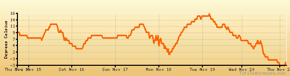
Temperature variation graph for the last seven days
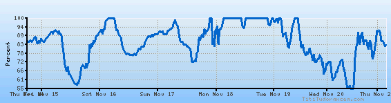
Humidity Variation Graph
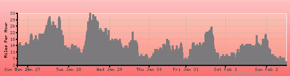
Wind speed
Weather Station: Monroe, Monroe Municipal Airport (latitude 42-36-54N, longitude 089-35-27W)
Local Time:
Monroe is in the "America/Chicago" timezone.
The "America/Chicago" timezone uses a Standard Time (ST) / Daylight Saving Time (DST) alternation scheme, and it currently is in DST (since Sunday, 9 March 2025, 03:00 AM local time). During DST, the timezone abbreviation is CDT and the offset to Universal Time (UTC, GMT or Zulu) is -5:00 hours.
Monroe will exit DST (returning to standard time) on Sunday, 2 November 2025, at 02:00 AM local time, when clocks will be turned backward 1 hour to Sunday, 2 November 2025, 01:00 AM local standard time. During ST, the timezone abbreviation is CST and the offset to UTC will be -6:00 hours.
Weather and Temperature in Wisconsin
Popular Weather Searches:
 If you own or manage a travel-related business such as a hotel, a bed-and-breakfast, a restaurant, a pub or a cafeteria, you can create a web page for your business for free on Titi Tudorancea Travel Info. » |