| Published in Weather / Wisconsin Weather Temperature |
Weather in Mineral Point, Iowa County, Wisconsin
Current Conditions (Sunday, February 2, 2025 at 02:15 America/Chicago time)
Temperature: 30°F (-1°C) |
Forecast Overview
Sun Feb 2 
48°F 28°F 9°C -2°C Mostly cloudy skies.
detailsMon Feb 3 39°F 21°F 4°C -6°C Mostly cloudy skies.
detailsTue Feb 4 
23°F 16°F -5°C -9°C Overcast skies.
detailsWed Feb 5 27°F 19°F -3°C -7°C Overcast skies.
detailsThu Feb 6 
32°F 12°F -0°C -11°C Chance of light snow before sunrise.
detailsFri Feb 7 27°F 10°F -3°C -12°C Mostly cloudy skies.
detailsSat Feb 8 
25°F 18°F -4°C -8°C Chance of snow all day.
detailsSun Feb 9 27°F 10°F -3°C -12°C Overcast skies.
detailsMon Feb 10 
28°F 10°F -2°C -12°C Chance of light snow in the afternoon.
details
Detailed Forecast
| Sunday, February 2 | sunrise: 07:16 sunset: 17:13 |
| Low around 29°F (-2°C), high around 49°F (9°C). Estimated precipitation: 0 in (0.0625 mm). Mostly cloudy skies. Wind: 11 mph (18 km/h). |
| Time | Skies | Conditions | Temp | Wind | Humidity | Soil Moisture |
| 00:00 03:00 | Overcast. Precipitation: 0 in (0.0625 mm). | 32°F (-0°C) | 11 mph (18 km/h) | 82% | 0.191% | |
| 03:00 06:00 | Overcast. | 32°F (-0°C) | 6 mph (9 km/h) | 93% | 0.191% | |
| 06:00 09:00 | Times of sun and clouds. | 34°F (1°C) | 6 mph (9 km/h) | 92% | 0.192% | |
| 09:00 12:00 | Sunny. | 44°F (7°C) | 9 mph (14 km/h) | 70% | 0.193% | |
| 12:00 15:00 | Mostly sunny, with a few passing clouds. | 49°F (9°C) | 8 mph (13 km/h) | 57% | 0.194% | |
| 15:00 18:00 | Overcast. | 42°F (5°C) | 3 mph (6 km/h) | 74% | 0.194% | |
| 18:00 21:00 | Overcast. | 41°F (5°C) | 5 mph (8 km/h) | 79% | 0.194% | |
| 21:00 00:00 | Overcast. | 40°F (4°C) | 3 mph (4 km/h) | 87% | 0.195% |
| Monday, February 3 | sunrise: 07:15 sunset: 17:15 |
| Low around 21°F (-6°C), high around 39°F (4°C). Mostly cloudy skies. Wind: 13 mph (21 km/h). |
| Time | Skies | Conditions | Temp | Wind | Humidity | Soil Moisture |
| 00:00 03:00 | Overcast. | 36°F (2°C) | 5 mph (7 km/h) | 90% | 0.195% | |
| 03:00 06:00 | Overcast. | 32°F (0°C) | 13 mph (21 km/h) | 77% | 0.195% | |
| 06:00 09:00 | Overcast. | 31°F (-0°C) | 13 mph (21 km/h) | 85% | 0.196% | |
| 09:00 12:00 | Overcast. | 32°F (-0°C) | 11 mph (17 km/h) | 78% | 0.196% | |
| 12:00 15:00 | Overcast. | 34°F (1°C) | 11 mph (18 km/h) | 74% | 0.196% | |
| 15:00 18:00 | Overcast. | 31°F (-1°C) | 11 mph (18 km/h) | 76% | 0.196% | |
| 18:00 21:00 | Clear. | 25°F (-4°C) | 12 mph (19 km/h) | 74% | 0.196% | |
| 21:00 00:00 | Clear. | 21°F (-6°C) | 10 mph (16 km/h) | 70% | 0.197% |
| Tuesday, February 4 | sunrise: 07:13 sunset: 17:16 |
| Low around 16°F (-9°C), high around 24°F (-5°C). Overcast skies. Wind: 11 mph (18 km/h). |
| Time | Skies | Conditions | Temp | Wind | Humidity | Soil Moisture |
| 00:00 03:00 | Clear. | 18°F (-8°C) | 11 mph (18 km/h) | 70% | 0.198% | |
| 03:00 06:00 | Overcast. | 17°F (-8°C) | 10 mph (15 km/h) | 72% | 0.199% | |
| 06:00 09:00 | Overcast. | 17°F (-8°C) | 10 mph (16 km/h) | 58% | 0.2% | |
| 09:00 12:00 | Overcast. | 22°F (-6°C) | 8 mph (13 km/h) | 47% | 0.201% | |
| 12:00 15:00 | Overcast. | 24°F (-5°C) | 8 mph (14 km/h) | 44% | 0.202% | |
| 15:00 18:00 | Overcast. | 22°F (-6°C) | 7 mph (12 km/h) | 49% | 0.202% | |
| 18:00 21:00 | Overcast. | 20°F (-7°C) | 7 mph (11 km/h) | 56% | 0.203% | |
| 21:00 00:00 | Overcast. | 20°F (-7°C) | 7 mph (12 km/h) | 59% | 0.204% |
| Wednesday, February 5 | sunrise: 07:12 sunset: 17:17 |
| Low around 19°F (-7°C), high around 27°F (-3°C). Estimated precipitation: 0 in (0.125 mm). Overcast skies. Wind: 11 mph (18 km/h). |
| Time | Skies | Conditions | Temp | Wind | Humidity | Soil Moisture |
| 00:00 03:00 | Overcast. | 19°F (-7°C) | 6 mph (10 km/h) | 63% | 0.205% | |
| 03:00 06:00 | Overcast. | 19°F (-7°C) | 8 mph (12 km/h) | 64% | 0.206% | |
| 06:00 09:00 | Overcast. | 22°F (-6°C) | 11 mph (18 km/h) | 67% | 0.207% | |
| 09:00 12:00 | Overcast. | 26°F (-3°C) | 11 mph (18 km/h) | 62% | 0.208% | |
| 12:00 15:00 | Overcast. | 27°F (-3°C) | 10 mph (15 km/h) | 68% | 0.209% | |
| 15:00 18:00 | Overcast. Precipitation: 0 in (0.0625 mm). | 25°F (-4°C) | 7 mph (12 km/h) | 89% | 0.209% | |
| 18:00 21:00 | Overcast. Precipitation: 0 in (0.0625 mm). | 25°F (-4°C) | 7 mph (11 km/h) | 89% | 0.21% | |
| 21:00 00:00 | Overcast. | 25°F (-4°C) | 4 mph (7 km/h) | 90% | 0.211% |
| Thursday, February 6 | sunrise: 07:11 sunset: 17:19 |
| Low around 13°F (-11°C), high around 31°F (-0°C). Chance of light snow before sunrise (between 3 am and 6 am). Estimated precipitation: 0 in (0.125 mm). More clouds than sun. Wind: 20 mph (33 km/h). |
| Time | Skies | Conditions | Temp | Wind | Humidity | Soil Moisture |
| 00:00 03:00 | Overcast. | 26°F (-3°C) | 4 mph (6 km/h) | 89% | 0.211% | |
| 03:00 06:00 | Chance of light snow. Precipitation: 0 in (0.0625 mm). | 26°F (-3°C) | 7 mph (11 km/h) | 91% | 0.212% | |
| 06:00 09:00 | Mostly cloudy. Precipitation: 0 in (0.0625 mm). | 28°F (-2°C) | 12 mph (20 km/h) | 83% | 0.213% | |
| 09:00 12:00 | Overcast. | 30°F (-1°C) | 20 mph (33 km/h) | 58% | 0.213% | |
| 12:00 15:00 | Sunny. | 27°F (-3°C) | 20 mph (33 km/h) | 44% | 0.212% | |
| 15:00 18:00 | Clear. | 20°F (-6°C) | 18 mph (29 km/h) | 52% | 0.212% | |
| 18:00 21:00 | Clear. | 16°F (-9°C) | 18 mph (28 km/h) | 56% | 0.212% | |
| 21:00 00:00 | Clear. | 13°F (-11°C) | 13 mph (22 km/h) | 61% | 0.213% |
| Friday, February 7 | sunrise: 07:10 sunset: 17:20 |
| Low around 11°F (-12°C), high around 26°F (-3°C). Mostly cloudy skies. Wind: 11 mph (17 km/h). |
| Time | Skies | Conditions | Temp | Wind | Humidity | Soil Moisture |
| 00:00 03:00 | Clear. | 12°F (-11°C) | 10 mph (16 km/h) | 63% | 0.214% | |
| 03:00 06:00 | Partly cloudy. | 11°F (-12°C) | 10 mph (16 km/h) | 65% | 0.215% | |
| 06:00 09:00 | Overcast. | 14°F (-10°C) | 11 mph (17 km/h) | 58% | 0.215% | |
| 09:00 12:00 | Overcast. | 21°F (-6°C) | 10 mph (16 km/h) | 45% | 0.216% | |
| 12:00 15:00 | Overcast. | 26°F (-3°C) | 9 mph (14 km/h) | 40% | 0.216% | |
| 15:00 18:00 | Overcast. | 23°F (-5°C) | 4 mph (7 km/h) | 51% | 0.216% | |
| 18:00 21:00 | Times of clear skies and clouds. | 20°F (-6°C) | 2 mph (4 km/h) | 61% | 0.217% | |
| 21:00 00:00 | Overcast. | 19°F (-7°C) | 1 mph (2 km/h) | 64% | 0.217% |
| Saturday, February 8 | sunrise: 07:09 sunset: 17:21 |
| Low around 18°F (-8°C), high around 25°F (-4°C). Chance of snow most of the day (from 6 am to 9 pm). Estimated precipitation: 0.26 in (6.625 mm). Overcast skies. Wind: 8 mph (13 km/h). |
| Time | Skies | Conditions | Temp | Wind | Humidity | Soil Moisture |
| 00:00 03:00 | Overcast. | 19°F (-7°C) | 5 mph (8 km/h) | 64% | 0.218% | |
| 03:00 06:00 | Overcast. | 20°F (-7°C) | 5 mph (8 km/h) | 63% | 0.219% | |
| 06:00 09:00 | Chance of light snow. Precipitation: 0 in (0.125 mm). | 23°F (-5°C) | 7 mph (11 km/h) | 55% | 0.219% | |
| 09:00 12:00 | Chance of snow. Precipitation: 0.06 in (1.5625 mm). | 23°F (-5°C) | 8 mph (13 km/h) | 86% | 0.219% | |
| 12:00 15:00 | Chance of snow. Precipitation: 0.1 in (2.4375 mm). | 24°F (-4°C) | 8 mph (13 km/h) | 92% | 0.22% | |
| 15:00 18:00 | Chance of snow. Precipitation: 0.05 in (1.3125 mm). | 23°F (-5°C) | 8 mph (13 km/h) | 96% | 0.22% | |
| 18:00 21:00 | Chance of light snow. Precipitation: 0.04 in (0.9375 mm). | 22°F (-5°C) | 6 mph (9 km/h) | 96% | 0.22% | |
| 21:00 00:00 | Partly cloudy. Precipitation: 0.01 in (0.25 mm). | 18°F (-8°C) | 5 mph (8 km/h) | 98% | 0.221% |
| Sunday, February 9 | sunrise: 07:07 sunset: 17:23 |
| Low around 10°F (-12°C), high around 27°F (-3°C). Overcast skies. Wind: 7 mph (11 km/h). |
| Time | Skies | Conditions | Temp | Wind | Humidity | Soil Moisture |
| 00:00 03:00 | Mostly cloudy. | 12°F (-11°C) | 4 mph (6 km/h) | 99% | 0.221% | |
| 03:00 06:00 | Overcast. | 10°F (-12°C) | 4 mph (7 km/h) | 100% | 0.222% | |
| 06:00 09:00 | Considerable cloudiness. | 17°F (-8°C) | 5 mph (8 km/h) | 91% | 0.222% | |
| 09:00 12:00 | Overcast. | 25°F (-4°C) | 6 mph (10 km/h) | 77% | 0.223% | |
| 12:00 15:00 | Overcast. | 27°F (-3°C) | 7 mph (11 km/h) | 73% | 0.225% | |
| 15:00 18:00 | Overcast. | 22°F (-6°C) | 5 mph (8 km/h) | 91% | 0.225% | |
| 18:00 21:00 | Overcast. | 19°F (-7°C) | 5 mph (7 km/h) | 93% | 0.225% | |
| 21:00 00:00 | Partly cloudy. | 20°F (-7°C) | 4 mph (7 km/h) | 93% | 0.226% |
| Monday, February 10 | sunrise: 07:06 sunset: 17:24 |
| Low around 10°F (-12°C), high around 29°F (-2°C). Chance of light snow early in the afternoon (between 12 pm and 3 pm). Estimated precipitation: 0 in (0.125 mm). Overcast skies. Wind: 14 mph (22 km/h). |
| Time | Skies | Conditions | Temp | Wind | Humidity | Soil Moisture |
| 00:00 03:00 | Overcast. | 17°F (-9°C) | 2 mph (3 km/h) | 97% | 0.226% | |
| 03:00 06:00 | Overcast. Precipitation: 0 in (0.0625 mm). | 16°F (-9°C) | 2 mph (3 km/h) | 97% | 0.226% | |
| 06:00 09:00 | Overcast. | 22°F (-6°C) | 3 mph (5 km/h) | 91% | 0.227% | |
| 09:00 12:00 | Overcast. | 28°F (-2°C) | 8 mph (13 km/h) | 81% | 0.23% | |
| 12:00 15:00 | Chance of light snow. Precipitation: 0 in (0.0625 mm). | 29°F (-2°C) | 12 mph (19 km/h) | 81% | 0.233% | |
| 15:00 18:00 | Overcast. | 19°F (-7°C) | 14 mph (22 km/h) | 86% | 0.233% | |
| 18:00 21:00 | Overcast. | 13°F (-11°C) | 13 mph (21 km/h) | 90% | 0.233% | |
| 21:00 00:00 | Partly cloudy. | 10°F (-12°C) | 12 mph (20 km/h) | 92% | 0.233% |
Climate Chart
» Mineral Point, Iowa County Climate Chart
Places with a similar climate: Dubuque (IA), Madison, Dane County (WI), Monroe (WI), Decorah (IA), Juneau, Dodge County (WI), Waukesha City/County (WI), Freeport (IL), Winona (MN), Fond Du Lac County (WI), West Bend (WI), Oshkosh (WI), Kenosha (WI), Appleton / Outagamie (WI), De Kalb (IL), Cedar Rapids (IA), Baraboo (WI), Prairie Du Chien (WI), Milwaukee / Timmerman (WI), Oelwein (IA), Chicago / Waukegan (IL), Vinton (IA), Watertown (WI), Janesville / Rock County (WI), La Crosse (WI), Lone Rock (WI).
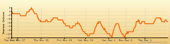
Temperature variation graph for the last seven days
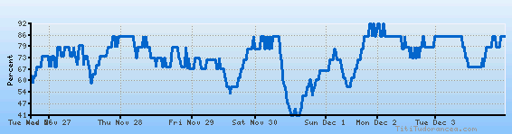
Humidity Variation Graph
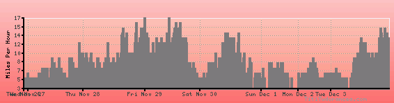
Wind speed
Weather Station: Mineral Point, Iowa County Airport (latitude 42-53-07N, longitude 090-13-55W)
Local Time:
Mineral Point, Iowa County is in the "America/Chicago" timezone.
The "America/Chicago" timezone uses a Standard Time (ST) / Daylight Saving Time (DST) alternation scheme, and it currently is in ST (since Sunday, 3 November 2024, 01:00 AM local time). During ST, the timezone abbreviation is CST and the offset to Universal Time (UTC, GMT or Zulu) is -6:00 hours.
Mineral Point, Iowa County will exit standard time (entering DST) on Sunday, 9 March 2025, at 02:00 AM local time, when clocks will be turned forward 1 hour to Sunday, 9 March 2025, 03:00 AM local daylight time. During DST, the timezone abbreviation is CDT and the offset to UTC will be -5:00 hours.
Weather and Temperature in Wisconsin
Popular Weather Searches:
 If you own or manage a travel-related business such as a hotel, a bed-and-breakfast, a restaurant, a pub or a cafeteria, you can create a web page for your business for free on Titi Tudorancea Travel Info. » |