| Published in Weather / Wisconsin Weather Temperature |
Weather in Medford, Taylor County, Wisconsin
Current Conditions (Thursday, March 13, 2025 at 11:15 America/Chicago time)
Temperature: 46°F (8°C) |
Forecast Overview
Fri Mar 14 
55°F 34°F 13°C 1°C Overcast skies.
detailsSat Mar 15 
66°F 41°F 19°C 5°C Chance of rain late at night.
detailsSun Mar 16 
50°F 25°F 10°C -4°C Chance of rain in the morning. Chance of snow after 4 pm.
detailsMon Mar 17 
34°F 21°F 1°C -6°C Partly cloudy skies.
detailsTue Mar 18 
41°F 23°F 5°C -5°C Times of sun and clouds.
detailsWed Mar 19 
48°F 30°F 9°C -1°C Chance of rain in the afternoon. Chance of ice pellets late at night. Chance of freezing rain after 7 pm.
detailsThu Mar 20 
32°F 23°F -0°C -5°C Chance of snow in the morning.
detailsFri Mar 21 
32°F 21°F 0°C -6°C Chance of light snow before sunrise.
detailsSat Mar 22 28°F 14°F -2°C -10°C More clouds than sun.
details
Detailed Forecast
| Friday, March 14 | sunrise: 07:17 sunset: 19:04 |
| Low around 34°F (1°C), high around 56°F (13°C). Overcast skies. Wind: 13 mph (21 km/h). |
| Time | Skies | Conditions | Temp | Wind | Humidity | Soil Moisture |
| 01:00 04:00 | Overcast. | 35°F (2°C) | 4 mph (6 km/h) | 73% | 0.304% | |
| 04:00 07:00 | Overcast. | 35°F (2°C) | 3 mph (4 km/h) | 73% | 0.304% | |
| 07:00 10:00 | Mostly cloudy. | 43°F (6°C) | 4 mph (7 km/h) | 59% | 0.303% | |
| 10:00 13:00 | Overcast. | 52°F (11°C) | 8 mph (12 km/h) | 43% | 0.299% | |
| 13:00 16:00 | Sunny. | 56°F (13°C) | 11 mph (18 km/h) | 43% | 0.294% | |
| 16:00 19:00 | Overcast. | 49°F (9°C) | 10 mph (16 km/h) | 61% | 0.292% | |
| 19:00 22:00 | Overcast. | 46°F (8°C) | 13 mph (21 km/h) | 67% | 0.291% | |
| 22:00 01:00 | Overcast. | 42°F (6°C) | 10 mph (17 km/h) | 74% | 0.291% |
| Saturday, March 15 | sunrise: 07:16 sunset: 19:05 |
| Low around 41°F (5°C), high around 66°F (19°C). Chance of rain late at night (after 10 pm). The precipitation may fall as scattered showers of varying intensity. Estimated precipitation: 0.45 in (11.4375 mm). Overcast skies. Wind: 19 mph (31 km/h). |
| Time | Skies | Conditions | Temp | Wind | Humidity | Soil Moisture |
| 01:00 04:00 | Overcast. | 41°F (5°C) | 10 mph (16 km/h) | 80% | 0.291% | |
| 04:00 07:00 | Overcast. Precipitation: 0.03 in (0.875 mm). | 43°F (6°C) | 11 mph (18 km/h) | 93% | 0.298% | |
| 07:00 10:00 | Overcast. Precipitation: 0.05 in (1.1875 mm). | 51°F (10°C) | 13 mph (22 km/h) | 89% | 0.309% | |
| 10:00 13:00 | Overcast. | 63°F (17°C) | 17 mph (28 km/h) | 69% | 0.305% | |
| 13:00 16:00 | Overcast. | 66°F (19°C) | 17 mph (27 km/h) | 65% | 0.301% | |
| 16:00 19:00 | Overcast. | 61°F (16°C) | 15 mph (25 km/h) | 67% | 0.299% | |
| 19:00 22:00 | Overcast. | 60°F (16°C) | 19 mph (31 km/h) | 71% | 0.298% | |
| 22:00 01:00 | Chance of rain. Precipitation: 0.37 in (9.375 mm). | 48°F (9°C) | 17 mph (27 km/h) | 88% | 0.374% |
| Sunday, March 16 | sunrise: 07:14 sunset: 19:07 |
| Low around 24°F (-4°C), high around 50°F (10°C). Chance of rain before sunrise (between 4 am and 7 am) and late in the morning (between 10 am and 1 pm). Chance of snow after 4 pm. Estimated precipitation: 0.25 in (6.3125 mm). Overcast skies. Wind: 17 mph (27 km/h). |
| Time | Skies | Conditions | Temp | Wind | Humidity | Soil Moisture |
| 01:00 04:00 | Mostly clear, with a few passing clouds. Precipitation: 0.01 in (0.1875 mm). | 42°F (6°C) | 14 mph (23 km/h) | 85% | 0.365% | |
| 04:00 07:00 | Chance of rain. Precipitation: 0.08 in (2.125 mm). | 44°F (7°C) | 14 mph (23 km/h) | 90% | 0.375% | |
| 07:00 10:00 | Times of sun and clouds. Precipitation: 0.07 in (1.6875 mm). | 46°F (8°C) | 17 mph (27 km/h) | 83% | 0.376% | |
| 10:00 13:00 | Chance of light rain. Precipitation: 0.03 in (0.875 mm). | 48°F (9°C) | 16 mph (25 km/h) | 84% | 0.368% | |
| 13:00 16:00 | Overcast. Precipitation: 0.04 in (1.0625 mm). | 38°F (4°C) | 17 mph (27 km/h) | 77% | 0.365% | |
| 16:00 19:00 | Chance of light snow. Precipitation: 0 in (0.0625 mm). | 32°F (0°C) | 17 mph (27 km/h) | 89% | 0.357% | |
| 19:00 22:00 | Chance of light snow. Precipitation: 0.01 in (0.25 mm). | 28°F (-2°C) | 16 mph (26 km/h) | 88% | 0.352% | |
| 22:00 01:00 | Chance of light snow. Precipitation: 0 in (0.0625 mm). | 24°F (-4°C) | 16 mph (26 km/h) | 84% | 0.35% |
| Monday, March 17 | sunrise: 07:12 sunset: 19:08 |
| Low around 21°F (-6°C), high around 34°F (1°C). Estimated precipitation: 0 in (0.125 mm). Partly cloudy skies. Wind: 19 mph (31 km/h). |
| Time | Skies | Conditions | Temp | Wind | Humidity | Soil Moisture |
| 01:00 04:00 | Overcast. Precipitation: 0 in (0.125 mm). | 24°F (-4°C) | 18 mph (29 km/h) | 72% | 0.351% | |
| 04:00 07:00 | Overcast. | 21°F (-6°C) | 18 mph (28 km/h) | 68% | 0.353% | |
| 07:00 10:00 | Overcast. | 23°F (-5°C) | 19 mph (30 km/h) | 55% | 0.354% | |
| 10:00 13:00 | Sunny. | 30°F (-1°C) | 19 mph (30 km/h) | 42% | 0.355% | |
| 13:00 16:00 | Sunny. | 33°F (1°C) | 19 mph (31 km/h) | 37% | 0.355% | |
| 16:00 19:00 | Overcast. | 29°F (-2°C) | 17 mph (27 km/h) | 45% | 0.354% | |
| 19:00 22:00 | Clear. | 26°F (-3°C) | 13 mph (21 km/h) | 52% | 0.355% | |
| 22:00 01:00 | Clear. | 24°F (-5°C) | 8 mph (13 km/h) | 61% | 0.357% |
| Tuesday, March 18 | sunrise: 07:10 sunset: 19:09 |
| Low around 23°F (-5°C), high around 42°F (5°C). Times of sun and clouds. Wind: 8 mph (13 km/h). |
| Time | Skies | Conditions | Temp | Wind | Humidity | Soil Moisture |
| 01:00 04:00 | Overcast. | 23°F (-5°C) | 5 mph (8 km/h) | 64% | 0.359% | |
| 04:00 07:00 | Overcast. | 23°F (-5°C) | 4 mph (7 km/h) | 63% | 0.362% | |
| 07:00 10:00 | Sunny. | 30°F (-1°C) | 5 mph (8 km/h) | 39% | 0.364% | |
| 10:00 13:00 | Sunny. | 39°F (4°C) | 7 mph (11 km/h) | 30% | 0.364% | |
| 13:00 16:00 | A few passing clouds. | 42°F (5°C) | 8 mph (13 km/h) | 43% | 0.361% | |
| 16:00 19:00 | Sunny. | 35°F (1°C) | 2 mph (4 km/h) | 69% | 0.359% | |
| 19:00 22:00 | Mostly clear. | 32°F (0°C) | 5 mph (7 km/h) | 80% | 0.358% | |
| 22:00 01:00 | Clear. | 31°F (-1°C) | 7 mph (12 km/h) | 87% | 0.359% |
| Wednesday, March 19 | sunrise: 07:08 sunset: 19:10 |
| Low around 30°F (-1°C), high around 48°F (9°C). Chance of rain during the afternoon (between 1 pm and 7 pm). Chance of ice pellets late at night (after 10 pm). Chance of freezing rain in the evening (between 7 pm and 10 pm). The precipitation may fall as scattered showers of varying intensity. Estimated precipitation: 0.16 in (4.0625 mm). Overcast skies. Wind: 20 mph (32 km/h). |
| Time | Skies | Conditions | Temp | Wind | Humidity | Soil Moisture |
| 01:00 04:00 | Overcast. | 31°F (-0°C) | 9 mph (15 km/h) | 89% | 0.359% | |
| 04:00 07:00 | Overcast. | 32°F (0°C) | 11 mph (18 km/h) | 86% | 0.359% | |
| 07:00 10:00 | Overcast. | 39°F (4°C) | 16 mph (26 km/h) | 73% | 0.359% | |
| 10:00 13:00 | Overcast. | 48°F (9°C) | 15 mph (24 km/h) | 72% | 0.354% | |
| 13:00 16:00 | Chance of light rain. Precipitation: 0 in (0.125 mm). | 42°F (6°C) | 14 mph (22 km/h) | 87% | 0.348% | |
| 16:00 19:00 | Chance of light rain. Precipitation: 0.01 in (0.375 mm). | 36°F (2°C) | 17 mph (27 km/h) | 90% | 0.346% | |
| 19:00 22:00 | Possibly freezing rain leading to formation of glaze ice. Precipitation: 0.03 in (0.6875 mm). | 32°F (-0°C) | 18 mph (29 km/h) | 90% | 0.346% | |
| 22:00 01:00 | Ice pellets possible. Precipitation: 0.11 in (2.875 mm). | 30°F (-1°C) | 20 mph (32 km/h) | 93% | 0.353% |
| Thursday, March 20 | sunrise: 07:06 sunset: 19:12 |
| Low around 23°F (-5°C), high around 31°F (-0°C). Chance of snow early in the morning (until 10 am). Estimated precipitation: 0.47 in (11.875 mm). Partly cloudy skies. Wind: 23 mph (37 km/h). |
| Time | Skies | Conditions | Temp | Wind | Humidity | Soil Moisture |
| 01:00 04:00 | Chance of snow. Precipitation: 0.37 in (9.5 mm). | 25°F (-4°C) | 23 mph (37 km/h) | 93% | 0.349% | |
| 04:00 07:00 | Chance of light snow. Precipitation: 0.04 in (0.9375 mm). | 24°F (-5°C) | 18 mph (30 km/h) | 89% | 0.347% | |
| 07:00 10:00 | Chance of snow. Precipitation: 0.05 in (1.375 mm). | 24°F (-4°C) | 16 mph (26 km/h) | 87% | 0.345% | |
| 10:00 13:00 | Overcast. Precipitation: 0 in (0.0625 mm). | 29°F (-2°C) | 15 mph (24 km/h) | 77% | 0.344% | |
| 13:00 16:00 | Times of sun and clouds. | 31°F (-0°C) | 14 mph (22 km/h) | 74% | 0.344% | |
| 16:00 19:00 | Sunny. | 27°F (-3°C) | 11 mph (17 km/h) | 78% | 0.343% | |
| 19:00 22:00 | Clear. | 24°F (-4°C) | 12 mph (20 km/h) | 89% | 0.343% | |
| 22:00 01:00 | Clear. | 23°F (-5°C) | 12 mph (20 km/h) | 93% | 0.343% |
| Friday, March 21 | sunrise: 07:04 sunset: 19:13 |
| Low around 22°F (-6°C), high around 32°F (0°C). Chance of light snow before sunrise (from 1 am to 7 am). Estimated precipitation: 0.02 in (0.4375 mm). Mostly cloudy skies. Wind: 16 mph (26 km/h). |
| Time | Skies | Conditions | Temp | Wind | Humidity | Soil Moisture |
| 01:00 04:00 | Chance of light snow. Precipitation: 0.01 in (0.25 mm). | 26°F (-3°C) | 14 mph (23 km/h) | 95% | 0.343% | |
| 04:00 07:00 | Chance of light snow. Precipitation: 0 in (0.125 mm). | 27°F (-3°C) | 16 mph (26 km/h) | 89% | 0.343% | |
| 07:00 10:00 | More clouds than sun. Precipitation: 0 in (0.0625 mm). | 28°F (-2°C) | 14 mph (23 km/h) | 84% | 0.344% | |
| 10:00 13:00 | Sunny. | 31°F (-1°C) | 13 mph (22 km/h) | 75% | 0.346% | |
| 13:00 16:00 | Sunny. | 32°F (0°C) | 12 mph (19 km/h) | 72% | 0.359% | |
| 16:00 19:00 | Overcast. | 25°F (-4°C) | 5 mph (8 km/h) | 83% | 0.36% | |
| 19:00 22:00 | Overcast. | 23°F (-5°C) | 5 mph (8 km/h) | 88% | 0.36% | |
| 22:00 01:00 | Overcast. | 22°F (-5°C) | 6 mph (9 km/h) | 89% | 0.36% |
| Saturday, March 22 | sunrise: 07:02 sunset: 19:14 |
| Low around 15°F (-10°C), high around 29°F (-2°C). More clouds than sun. Wind: 11 mph (17 km/h). |
| Time | Skies | Conditions | Temp | Wind | Humidity | Soil Moisture |
| 01:00 04:00 | Overcast. | 20°F (-7°C) | 4 mph (7 km/h) | 92% | 0.361% | |
| 04:00 07:00 | Clear. | 17°F (-8°C) | 7 mph (11 km/h) | 92% | 0.363% | |
| 07:00 10:00 | Mostly sunny. | 21°F (-6°C) | 10 mph (16 km/h) | 73% | 0.364% | |
| 10:00 13:00 | Overcast. | 26°F (-3°C) | 10 mph (15 km/h) | 63% | 0.366% | |
| 13:00 16:00 | Overcast. | 28°F (-2°C) | 11 mph (17 km/h) | 60% | 0.367% | |
| 16:00 19:00 | Sunny. | 23°F (-5°C) | 7 mph (11 km/h) | 77% | 0.369% | |
| 19:00 22:00 | Clear. | 18°F (-8°C) | 5 mph (9 km/h) | 86% | 0.371% | |
| 22:00 01:00 | Clear. | 15°F (-10°C) | 2 mph (3 km/h) | 88% | 0.373% |
Climate Chart
» Medford, Taylor County Climate Chart
Places with a similar climate: Wausau (WI), Marshfield (WI), Mosinee / Central Wisconsin (WI), Ladysmith, Ruck County (WI), Rice Lake (WI), Wisconsin Rapids, Wood County (WI), New Richmond (WI), Stevens Point (WI), Phillips, Price County (WI), Eau Claire, Chippewa Valley (WI), Minocqua/Woodruff (WI), Rush City (MN), Wautoma (WI), Clintonville (WI), Green Bay (WI), Iron Mountain / Kingsford (MI), Cambridge (MN), Hutchinson (MN), Menominee / Marinette County (MI), Volk (WI), St Cloud (MN), Minneapolis / Blaine (MN), Worthington (MN), Waseca (MN), Rhinelander, Oneida County (WI).
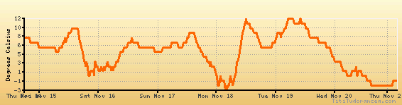
Temperature variation graph for the last seven days
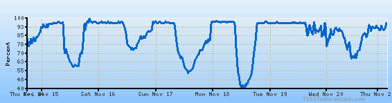
Humidity Variation Graph
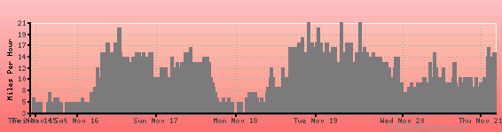
Wind speed
Weather Station: Medford, Taylor County Airport (latitude 45-06-04N, longitude 090-18-12W)
Local Time:
Medford, Taylor County is in the "America/Chicago" timezone.
The "America/Chicago" timezone uses a Standard Time (ST) / Daylight Saving Time (DST) alternation scheme, and it currently is in DST (since Sunday, 9 March 2025, 03:00 AM local time). During DST, the timezone abbreviation is CDT and the offset to Universal Time (UTC, GMT or Zulu) is -5:00 hours.
Medford, Taylor County will exit DST (returning to standard time) on Sunday, 2 November 2025, at 02:00 AM local time, when clocks will be turned backward 1 hour to Sunday, 2 November 2025, 01:00 AM local standard time. During ST, the timezone abbreviation is CST and the offset to UTC will be -6:00 hours.
Weather and Temperature in Wisconsin
Popular Weather Searches:
 If you own or manage a travel-related business such as a hotel, a bed-and-breakfast, a restaurant, a pub or a cafeteria, you can create a web page for your business for free on Titi Tudorancea Travel Info. » |