| Published in Weather / Japan Weather Temperature |
Weather in Matsuyama, Japan
Current Conditions (Monday, February 17, 2025 at 12:00 Asia/Tokyo time)
Temperature: 50°F (10°C) |
Forecast Overview
Tue Feb 18 
41°F 34°F 5°C 1°C Chance of light snow in the morning.
detailsWed Feb 19 41°F 32°F 5°C -0°C Chance of light snow at various times.
detailsThu Feb 20 
43°F 30°F 6°C -1°C Chance of light snow before sunrise.
detailsFri Feb 21 
45°F 32°F 7°C -0°C Partly cloudy skies.
detailsSat Feb 22 41°F 34°F 5°C 1°C Chance of light snow in the morning and late at night.
detailsSun Feb 23 
39°F 32°F 4°C -0°C Chance of light snow almost all day.
detailsMon Feb 24 
45°F 30°F 7°C -1°C Mostly sunny.
detailsTue Feb 25 
50°F 32°F 10°C 0°C Mostly cloudy skies.
detailsWed Feb 26 
46°F 41°F 8°C 5°C Chance of rain until 6 pm.
details
Detailed Forecast
| Monday, February 17 | sunrise: 06:53 sunset: 17:53 |
| Overcast skies. Wind: 18 mph (29 km/h). |
| Time | Skies | Conditions | Temp | Wind | Humidity | Soil Moisture |
| 12:00 15:00 | Overcast. | 44°F (7°C) | 18 mph (29 km/h) | 44% | 0.308% | |
| 15:00 18:00 | Partly cloudy. | 37°F (3°C) | 17 mph (28 km/h) | 50% | 0.306% | |
| 18:00 21:00 | Overcast. | 36°F (2°C) | 12 mph (20 km/h) | 46% | 0.305% | |
| 21:00 00:00 | Overcast. | 34°F (1°C) | 7 mph (11 km/h) | 56% | 0.306% |
| Tuesday, February 18 | sunrise: 06:52 sunset: 17:54 |
| Low around 33°F (1°C), high around 41°F (5°C). Chance of light snow early in the morning (between 6 am and 9 am). Estimated precipitation: 0.02 in (0.5 mm). Mostly cloudy skies. Wind: 16 mph (25 km/h). |
| Time | Skies | Conditions | Temp | Wind | Humidity | Soil Moisture |
| 00:00 03:00 | Overcast. | 34°F (1°C) | 6 mph (9 km/h) | 59% | 0.306% | |
| 03:00 06:00 | Overcast. | 34°F (1°C) | 3 mph (5 km/h) | 61% | 0.306% | |
| 06:00 09:00 | Chance of light snow. Precipitation: 0.02 in (0.4375 mm). | 36°F (2°C) | 14 mph (23 km/h) | 69% | 0.307% | |
| 09:00 12:00 | Overcast. Precipitation: 0 in (0.0625 mm). | 39°F (4°C) | 11 mph (18 km/h) | 44% | 0.305% | |
| 12:00 15:00 | Considerable cloudiness. | 40°F (5°C) | 16 mph (25 km/h) | 41% | 0.302% | |
| 15:00 18:00 | Partly cloudy. | 36°F (2°C) | 15 mph (23 km/h) | 52% | 0.3% | |
| 18:00 21:00 | Overcast. | 34°F (1°C) | 11 mph (18 km/h) | 51% | 0.299% | |
| 21:00 00:00 | Partly cloudy. | 34°F (1°C) | 11 mph (18 km/h) | 52% | 0.299% |
| Wednesday, February 19 | sunrise: 06:51 sunset: 17:55 |
| Low around 32°F (-0°C), high around 42°F (5°C). Chance of light snow early in the morning (between 6 am and 9 am) and in the evening (after 6 pm). Estimated precipitation: 0.01 in (0.3125 mm). Mostly cloudy skies. Wind: 16 mph (26 km/h). |
| Time | Skies | Conditions | Temp | Wind | Humidity | Soil Moisture |
| 00:00 03:00 | Partly cloudy. | 33°F (1°C) | 13 mph (21 km/h) | 57% | 0.298% | |
| 03:00 06:00 | Considerable cloudiness. | 32°F (-0°C) | 11 mph (18 km/h) | 61% | 0.299% | |
| 06:00 09:00 | Chance of light snow. Precipitation: 0 in (0.0625 mm). | 34°F (1°C) | 12 mph (20 km/h) | 57% | 0.299% | |
| 09:00 12:00 | Overcast. Precipitation: 0 in (0.0625 mm). | 38°F (3°C) | 12 mph (19 km/h) | 46% | 0.298% | |
| 12:00 15:00 | Overcast. | 41°F (5°C) | 16 mph (26 km/h) | 41% | 0.295% | |
| 15:00 18:00 | Mostly cloudy. | 37°F (3°C) | 13 mph (22 km/h) | 51% | 0.294% | |
| 18:00 21:00 | Chance of light snow. Precipitation: 0 in (0.0625 mm). | 35°F (1°C) | 9 mph (15 km/h) | 66% | 0.294% | |
| 21:00 00:00 | Chance of light snow. Precipitation: 0 in (0.125 mm). | 33°F (1°C) | 5 mph (8 km/h) | 73% | 0.296% |
| Thursday, February 20 | sunrise: 06:50 sunset: 17:56 |
| Low around 31°F (-1°C), high around 43°F (6°C). Chance of light snow between midnight and 3 am. Estimated precipitation: 0.01 in (0.1875 mm). Times of sun and clouds. Wind: 8 mph (13 km/h). |
| Time | Skies | Conditions | Temp | Wind | Humidity | Soil Moisture |
| 00:00 03:00 | Chance of light snow. Precipitation: 0.01 in (0.1875 mm). | 34°F (1°C) | 8 mph (13 km/h) | 65% | 0.296% | |
| 03:00 06:00 | Times of clear skies and clouds. | 31°F (-0°C) | 4 mph (7 km/h) | 70% | 0.297% | |
| 06:00 09:00 | Sunny. | 37°F (3°C) | 7 mph (11 km/h) | 48% | 0.297% | |
| 09:00 12:00 | Sunny. | 39°F (4°C) | 7 mph (11 km/h) | 42% | 0.295% | |
| 12:00 15:00 | Sunny. | 42°F (5°C) | 3 mph (5 km/h) | 38% | 0.295% | |
| 15:00 18:00 | Clear. | 37°F (3°C) | 2 mph (3 km/h) | 47% | 0.293% | |
| 18:00 21:00 | Overcast. | 33°F (1°C) | 4 mph (6 km/h) | 58% | 0.294% | |
| 21:00 00:00 | Overcast. | 33°F (1°C) | 5 mph (7 km/h) | 61% | 0.294% |
| Friday, February 21 | sunrise: 06:49 sunset: 17:57 |
| Low around 32°F (-0°C), high around 44°F (7°C). Partly cloudy skies. Wind: 10 mph (16 km/h). |
| Time | Skies | Conditions | Temp | Wind | Humidity | Soil Moisture |
| 00:00 03:00 | Overcast. | 33°F (1°C) | 3 mph (5 km/h) | 66% | 0.295% | |
| 03:00 06:00 | Overcast. | 33°F (1°C) | 3 mph (4 km/h) | 69% | 0.296% | |
| 06:00 09:00 | Overcast. | 38°F (4°C) | 1 mph (2 km/h) | 55% | 0.296% | |
| 09:00 12:00 | A few passing clouds. | 42°F (6°C) | 4 mph (7 km/h) | 44% | 0.295% | |
| 12:00 15:00 | Sunny. | 43°F (6°C) | 6 mph (9 km/h) | 47% | 0.292% | |
| 15:00 18:00 | Clear. | 40°F (4°C) | 10 mph (16 km/h) | 45% | 0.291% | |
| 18:00 21:00 | Mostly cloudy. | 35°F (1°C) | 7 mph (11 km/h) | 60% | 0.291% | |
| 21:00 00:00 | Overcast. | 33°F (1°C) | 2 mph (3 km/h) | 60% | 0.292% |
| Saturday, February 22 | sunrise: 06:48 sunset: 17:58 |
| Low around 33°F (1°C), high around 41°F (5°C). Chance of light snow in the morning (between 9 am and 12 pm) and at night (after 9 pm). Estimated precipitation: 0.01 in (0.25 mm). Mostly cloudy skies. Wind: 15 mph (24 km/h). |
| Time | Skies | Conditions | Temp | Wind | Humidity | Soil Moisture |
| 00:00 03:00 | Overcast. | 35°F (1°C) | 8 mph (13 km/h) | 57% | 0.292% | |
| 03:00 06:00 | Overcast. | 34°F (1°C) | 11 mph (17 km/h) | 59% | 0.292% | |
| 06:00 09:00 | Sunny. | 36°F (2°C) | 11 mph (18 km/h) | 53% | 0.292% | |
| 09:00 12:00 | Chance of light snow. Precipitation: 0 in (0.0625 mm). | 38°F (3°C) | 9 mph (15 km/h) | 50% | 0.29% | |
| 12:00 15:00 | Overcast. | 40°F (4°C) | 15 mph (24 km/h) | 39% | 0.288% | |
| 15:00 18:00 | Overcast. | 36°F (2°C) | 10 mph (17 km/h) | 48% | 0.286% | |
| 18:00 21:00 | Overcast. | 33°F (1°C) | 8 mph (14 km/h) | 66% | 0.286% | |
| 21:00 00:00 | Chance of light snow. Precipitation: 0.01 in (0.1875 mm). | 34°F (1°C) | 8 mph (14 km/h) | 58% | 0.287% |
| Sunday, February 23 | sunrise: 06:47 sunset: 17:59 |
| Low around 31°F (-0°C), high around 39°F (4°C). Chance of light snow most of the night and day, except evening between 6 pm and 9 pm. Estimated precipitation: 0.1 in (2.5625 mm). Considerable cloudiness. Wind: 18 mph (28 km/h). |
| Time | Skies | Conditions | Temp | Wind | Humidity | Soil Moisture |
| 00:00 03:00 | Chance of light snow. Precipitation: 0 in (0.0625 mm). | 33°F (0°C) | 9 mph (15 km/h) | 66% | 0.288% | |
| 03:00 06:00 | Chance of light snow. Precipitation: 0.01 in (0.3125 mm). | 33°F (1°C) | 13 mph (20 km/h) | 64% | 0.288% | |
| 06:00 09:00 | Chance of light snow. Precipitation: 0.01 in (0.25 mm). | 34°F (1°C) | 14 mph (22 km/h) | 61% | 0.289% | |
| 09:00 12:00 | Chance of light snow. Precipitation: 0.01 in (0.375 mm). | 37°F (3°C) | 15 mph (24 km/h) | 48% | 0.288% | |
| 12:00 15:00 | Chance of light snow. Precipitation: 0.01 in (0.1875 mm). | 39°F (4°C) | 16 mph (25 km/h) | 40% | 0.287% | |
| 15:00 18:00 | Chance of light snow. Precipitation: 0 in (0.0625 mm). | 36°F (2°C) | 18 mph (28 km/h) | 59% | 0.286% | |
| 18:00 21:00 | Mostly clear. Precipitation: 0.03 in (0.6875 mm). | 33°F (1°C) | 9 mph (14 km/h) | 75% | 0.287% | |
| 21:00 00:00 | Chance of light snow. Precipitation: 0.02 in (0.625 mm). | 35°F (1°C) | 12 mph (19 km/h) | 70% | 0.288% |
| Monday, February 24 | sunrise: 06:45 sunset: 17:59 |
| Low around 30°F (-1°C), high around 45°F (7°C). Mostly sunny. Wind: 11 mph (17 km/h). |
| Time | Skies | Conditions | Temp | Wind | Humidity | Soil Moisture |
| 00:00 03:00 | Clear. | 34°F (1°C) | 11 mph (17 km/h) | 59% | 0.288% | |
| 03:00 06:00 | Considerable cloudiness. | 30°F (-1°C) | 6 mph (9 km/h) | 71% | 0.288% | |
| 06:00 09:00 | A few passing clouds. | 38°F (3°C) | 8 mph (12 km/h) | 49% | 0.287% | |
| 09:00 12:00 | Sunny. | 42°F (6°C) | 9 mph (15 km/h) | 42% | 0.286% | |
| 12:00 15:00 | Sunny. | 44°F (7°C) | 5 mph (7 km/h) | 39% | 0.283% | |
| 15:00 18:00 | Clear. | 37°F (3°C) | 2 mph (3 km/h) | 59% | 0.283% | |
| 18:00 21:00 | Clear. | 34°F (1°C) | 6 mph (9 km/h) | 66% | 0.283% | |
| 21:00 00:00 | Clear. | 33°F (1°C) | 6 mph (10 km/h) | 63% | 0.284% |
| Tuesday, February 25 | sunrise: 06:44 sunset: 18:00 |
| Low around 33°F (0°C), high around 50°F (10°C). Estimated precipitation: 0 in (0.0625 mm). Mostly cloudy skies. Wind: 6 mph (9 km/h). |
| Time | Skies | Conditions | Temp | Wind | Humidity | Soil Moisture |
| 00:00 03:00 | Partly cloudy. | 33°F (1°C) | 5 mph (9 km/h) | 64% | 0.284% | |
| 03:00 06:00 | Clear. | 33°F (1°C) | 6 mph (9 km/h) | 71% | 0.284% | |
| 06:00 09:00 | Overcast. | 44°F (6°C) | 1 mph (2 km/h) | 45% | 0.284% | |
| 09:00 12:00 | Overcast. | 49°F (10°C) | 5 mph (9 km/h) | 42% | 0.282% | |
| 12:00 15:00 | Mostly cloudy. | 49°F (9°C) | 5 mph (8 km/h) | 49% | 0.28% | |
| 15:00 18:00 | Overcast. | 44°F (6°C) | 2 mph (3 km/h) | 56% | 0.279% | |
| 18:00 21:00 | Overcast. | 43°F (6°C) | 3 mph (5 km/h) | 47% | 0.28% | |
| 21:00 00:00 | Overcast. Precipitation: 0 in (0.0625 mm). | 42°F (5°C) | 5 mph (7 km/h) | 59% | 0.28% |
| Wednesday, February 26 | sunrise: 06:43 sunset: 18:01 |
| Low around 42°F (5°C), high around 47°F (8°C). Chance of rain all morning and afternoon (between 3 am and 6 pm). Estimated precipitation: 0.27 in (6.875 mm). Overcast skies. Wind: 4 mph (7 km/h). |
| Time | Skies | Conditions | Temp | Wind | Humidity | Soil Moisture |
| 00:00 03:00 | Overcast. | 43°F (6°C) | 4 mph (7 km/h) | 62% | 0.281% | |
| 03:00 06:00 | Chance of light rain. Precipitation: 0.02 in (0.625 mm). | 42°F (6°C) | 2 mph (4 km/h) | 86% | 0.284% | |
| 06:00 09:00 | Chance of rain. Precipitation: 0.06 in (1.4375 mm). | 43°F (6°C) | 3 mph (4 km/h) | 93% | 0.293% | |
| 09:00 12:00 | Chance of rain. Precipitation: 0.11 in (2.8125 mm). | 45°F (7°C) | 1 mph (1 km/h) | 94% | 0.314% | |
| 12:00 15:00 | Chance of light rain. Precipitation: 0.04 in (0.9375 mm). | 45°F (7°C) | 2 mph (4 km/h) | 96% | 0.315% | |
| 15:00 18:00 | Chance of light rain. Precipitation: 0.04 in (0.9375 mm). | 46°F (8°C) | 3 mph (4 km/h) | 94% | 0.315% | |
| 18:00 21:00 | Overcast. Precipitation: 0 in (0.125 mm). | 46°F (8°C) | 2 mph (3 km/h) | 93% | 0.312% | |
| 21:00 00:00 | Overcast. | 46°F (8°C) | 2 mph (3 km/h) | 93% | 0.31% |
Climate Chart
Places with a similar climate: Nagoya, Iwakuni, Oita, Kansai, Kitakyushu, Ube, Yamaguchi, Tokyo, Kobe, Nagasaki, Nankishirahama, Fukuoka, Chofu, Kochi, Hiroshimanishi, Tokyo, Iwami, Hofu, Hatteras (NC, US), Cheju (Korea, South), Genova / Sestri (Italy), Tsushima, Shanghai / Pudong (China), Hamamatsu, Ashiya, Miyazaki.
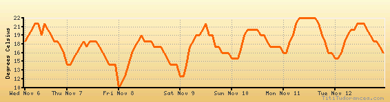
Temperature variation graph for the last seven days
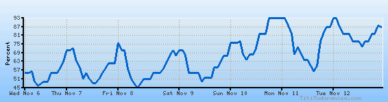
Humidity Variation Graph
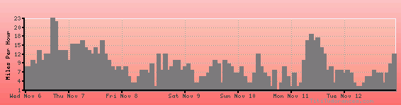
Wind speed
Weather Station: Matsuyama Airport (latitude 33-49N, longitude 132-42E)
Local Time:
Matsuyama is in the "Asia/Tokyo" timezone, commonly abbreviated JST.
This timezone does not apply the Daylight Saving Time (DST) scheme - it uses standard time throughout the year. The offset to Universal Time (UTC, GMT or Zulu) is +9:00 hours.
Weather and Temperature in Japan
Popular Weather Searches:
 If you own or manage a travel-related business such as a hotel, a bed-and-breakfast, a restaurant, a pub or a cafeteria, you can create a web page for your business for free on Titi Tudorancea Travel Info. » |