| Published in Weather / Vermont Weather Temperature |
Weather in Lyndonville, Caledonia County, Vermont
Current Conditions (Tuesday, March 11, 2025 at 20:55 America/New_York time)
Temperature: 48°F (9°C) |
Forecast Overview
Wed Mar 12 
41°F 10°F 5°C -12°C Mostly cloudy skies.
detailsThu Mar 13 
36°F 18°F 2°C -8°C Chance of light snow in the morning.
detailsFri Mar 14 48°F 28°F 9°C -2°C Considerable cloudiness.
detailsSat Mar 15 
48°F 30°F 9°C -1°C Overcast skies.
detailsSun Mar 16 
57°F 39°F 14°C 4°C Chance of rain in the afternoon.
detailsMon Mar 17 
57°F 30°F 14°C -1°C Chance of rain in the morning. Chance of snow in the afternoon.
detailsTue Mar 18 
52°F 27°F 11°C -3°C Times of sun and clouds.
detailsWed Mar 19 59°F 34°F 15°C 1°C Mostly cloudy skies.
detailsThu Mar 20 48°F 30°F 9°C -1°C Chance of rain in the morning. Chance of snow in the morning and in the evening.
details
Detailed Forecast
| Wednesday, March 12 | sunrise: 07:08 sunset: 18:48 |
| Low around 11°F (-12°C), high around 41°F (5°C). Estimated precipitation: 0 in (0.125 mm). Mostly cloudy skies. Wind: 8 mph (14 km/h). |
| Time | Skies | Conditions | Temp | Wind | Humidity | Soil Moisture |
| 23:00 02:00 | Clear. Precipitation: 0 in (0.0625 mm). | 18°F (-8°C) | 8 mph (14 km/h) | 87% | 0.449% | |
| 02:00 05:00 | Overcast. | 15°F (-9°C) | 5 mph (8 km/h) | 93% | 0.449% | |
| 05:00 08:00 | Mostly sunny. Precipitation: 0 in (0.0625 mm). | 13°F (-11°C) | 3 mph (5 km/h) | 91% | 0.449% | |
| 08:00 11:00 | Overcast. | 21°F (-6°C) | 4 mph (6 km/h) | 66% | 0.449% | |
| 11:00 14:00 | Overcast. | 26°F (-3°C) | 4 mph (7 km/h) | 61% | 0.449% | |
| 14:00 17:00 | Overcast. | 25°F (-4°C) | 3 mph (5 km/h) | 68% | 0.449% | |
| 17:00 20:00 | Overcast. | 22°F (-5°C) | 1 mph (2 km/h) | 89% | 0.449% | |
| 20:00 23:00 | Overcast. | 21°F (-6°C) | 1 mph (2 km/h) | 92% | 0.449% |
| Thursday, March 13 | sunrise: 07:06 sunset: 18:50 |
| Low around 18°F (-8°C), high around 36°F (2°C). Chance of light snow early in the morning (between 5 am and 8 am). Estimated precipitation: 0.02 in (0.5 mm). Overcast skies. Wind: 7 mph (12 km/h). |
| Time | Skies | Conditions | Temp | Wind | Humidity | Soil Moisture |
| 23:00 02:00 | Overcast. | 21°F (-6°C) | 2 mph (4 km/h) | 93% | 0.449% | |
| 02:00 05:00 | Overcast. | 20°F (-7°C) | 2 mph (4 km/h) | 94% | 0.449% | |
| 05:00 08:00 | Chance of light snow. Precipitation: 0.01 in (0.3125 mm). | 24°F (-5°C) | 3 mph (5 km/h) | 95% | 0.449% | |
| 08:00 11:00 | Overcast. Precipitation: 0 in (0.125 mm). | 31°F (-0°C) | 6 mph (10 km/h) | 85% | 0.449% | |
| 11:00 14:00 | Overcast. Precipitation: 0 in (0.0625 mm). | 35°F (2°C) | 7 mph (11 km/h) | 81% | 0.449% | |
| 14:00 17:00 | Overcast. | 34°F (1°C) | 7 mph (12 km/h) | 84% | 0.449% | |
| 17:00 20:00 | Overcast. | 31°F (-1°C) | 3 mph (5 km/h) | 94% | 0.449% | |
| 20:00 23:00 | Overcast. | 30°F (-1°C) | 3 mph (5 km/h) | 96% | 0.449% |
| Friday, March 14 | sunrise: 07:04 sunset: 18:51 |
| Low around 28°F (-2°C), high around 49°F (9°C). Considerable cloudiness. Wind: 7 mph (11 km/h). |
| Time | Skies | Conditions | Temp | Wind | Humidity | Soil Moisture |
| 23:00 02:00 | Overcast. | 30°F (-1°C) | 3 mph (5 km/h) | 97% | 0.449% | |
| 02:00 05:00 | Overcast. | 30°F (-1°C) | 2 mph (4 km/h) | 98% | 0.449% | |
| 05:00 08:00 | Sunny. | 29°F (-2°C) | 3 mph (5 km/h) | 98% | 0.449% | |
| 08:00 11:00 | Considerable cloudiness. | 38°F (3°C) | 5 mph (7 km/h) | 91% | 0.449% | |
| 11:00 14:00 | Sunny. | 47°F (8°C) | 6 mph (9 km/h) | 77% | 0.449% | |
| 14:00 17:00 | Overcast. | 46°F (8°C) | 7 mph (11 km/h) | 85% | 0.449% | |
| 17:00 20:00 | Overcast. | 33°F (1°C) | 3 mph (6 km/h) | 97% | 0.447% | |
| 20:00 23:00 | Overcast. | 34°F (1°C) | 3 mph (5 km/h) | 99% | 0.445% |
| Saturday, March 15 | sunrise: 07:02 sunset: 18:52 |
| Low around 30°F (-1°C), high around 49°F (9°C). Estimated precipitation: 0.01 in (0.375 mm). Overcast skies. Wind: 10 mph (16 km/h). |
| Time | Skies | Conditions | Temp | Wind | Humidity | Soil Moisture |
| 23:00 02:00 | Mostly cloudy. | 31°F (-1°C) | 3 mph (5 km/h) | 99% | 0.442% | |
| 02:00 05:00 | Overcast. | 31°F (-1°C) | 3 mph (5 km/h) | 99% | 0.44% | |
| 05:00 08:00 | Overcast. | 35°F (1°C) | 4 mph (6 km/h) | 98% | 0.439% | |
| 08:00 11:00 | Overcast. | 44°F (7°C) | 8 mph (14 km/h) | 90% | 0.44% | |
| 11:00 14:00 | Overcast. | 48°F (9°C) | 10 mph (16 km/h) | 87% | 0.437% | |
| 14:00 17:00 | Overcast. | 46°F (8°C) | 9 mph (14 km/h) | 90% | 0.421% | |
| 17:00 20:00 | Overcast. | 40°F (5°C) | 5 mph (8 km/h) | 96% | 0.398% | |
| 20:00 23:00 | Overcast. Precipitation: 0.01 in (0.375 mm). | 40°F (5°C) | 4 mph (6 km/h) | 99% | 0.379% |
| Sunday, March 16 | sunrise: 07:01 sunset: 18:53 |
| Low around 39°F (4°C), high around 58°F (14°C). Chance of rain late in the afternoon (between 2 pm and 5 pm). Estimated precipitation: 0.36 in (9.0625 mm). Overcast skies. Wind: 17 mph (28 km/h). |
| Time | Skies | Conditions | Temp | Wind | Humidity | Soil Moisture |
| 23:00 02:00 | Overcast. Precipitation: 0 in (0.0625 mm). | 41°F (5°C) | 4 mph (6 km/h) | 100% | 0.361% | |
| 02:00 05:00 | Overcast. | 43°F (6°C) | 5 mph (8 km/h) | 100% | 0.346% | |
| 05:00 08:00 | Overcast. | 51°F (10°C) | 10 mph (16 km/h) | 95% | 0.336% | |
| 08:00 11:00 | Overcast. | 54°F (12°C) | 13 mph (21 km/h) | 93% | 0.328% | |
| 11:00 14:00 | Overcast. | 56°F (13°C) | 14 mph (23 km/h) | 91% | 0.321% | |
| 14:00 17:00 | Chance of light rain. Precipitation: 0.02 in (0.4375 mm). | 56°F (13°C) | 14 mph (22 km/h) | 93% | 0.32% | |
| 17:00 20:00 | Overcast. Precipitation: 0.06 in (1.5625 mm). | 57°F (14°C) | 16 mph (27 km/h) | 90% | 0.326% | |
| 20:00 23:00 | Overcast. Precipitation: 0.28 in (7 mm). | 58°F (14°C) | 17 mph (28 km/h) | 87% | 0.36% |
| Monday, March 17 | sunrise: 06:59 sunset: 18:55 |
| Low around 31°F (-1°C), high around 58°F (14°C). Chance of rain early in the morning (until 8 am). Chance of snow during the afternoon (between 11 am and 5 pm). Estimated precipitation: 0.19 in (4.75 mm). Mostly cloudy skies. Wind: 10 mph (17 km/h). |
| Time | Skies | Conditions | Temp | Wind | Humidity | Soil Moisture |
| 23:00 02:00 | Chance of rain. Precipitation: 0.14 in (3.5625 mm). | 54°F (12°C) | 8 mph (14 km/h) | 94% | 0.36% | |
| 02:00 05:00 | Chance of light rain. Precipitation: 0.03 in (0.75 mm). | 50°F (10°C) | 8 mph (12 km/h) | 91% | 0.345% | |
| 05:00 08:00 | Chance of light rain. Precipitation: 0 in (0.0625 mm). | 45°F (7°C) | 3 mph (5 km/h) | 91% | 0.333% | |
| 08:00 11:00 | Mostly cloudy. Precipitation: 0 in (0.0625 mm). | 44°F (7°C) | 6 mph (10 km/h) | 73% | 0.323% | |
| 11:00 14:00 | Chance of light snow. Precipitation: 0 in (0.0625 mm). | 38°F (4°C) | 8 mph (13 km/h) | 82% | 0.314% | |
| 14:00 17:00 | Chance of light snow. Precipitation: 0.01 in (0.25 mm). | 39°F (4°C) | 10 mph (17 km/h) | 75% | 0.309% | |
| 17:00 20:00 | Clear. | 32°F (0°C) | 8 mph (14 km/h) | 70% | 0.303% | |
| 20:00 23:00 | Considerable cloudiness. | 31°F (-1°C) | 10 mph (15 km/h) | 76% | 0.3% |
| Tuesday, March 18 | sunrise: 06:57 sunset: 18:56 |
| Low around 27°F (-3°C), high around 52°F (11°C). Times of sun and clouds. Wind: 12 mph (19 km/h). |
| Time | Skies | Conditions | Temp | Wind | Humidity | Soil Moisture |
| 23:00 02:00 | Clear. | 29°F (-2°C) | 6 mph (9 km/h) | 73% | 0.299% | |
| 02:00 05:00 | Clear. | 28°F (-2°C) | 2 mph (3 km/h) | 76% | 0.299% | |
| 05:00 08:00 | Sunny. | 30°F (-1°C) | 3 mph (5 km/h) | 69% | 0.3% | |
| 08:00 11:00 | Mostly sunny, with a few passing clouds. | 41°F (5°C) | 8 mph (12 km/h) | 39% | 0.3% | |
| 11:00 14:00 | Overcast. | 51°F (11°C) | 12 mph (19 km/h) | 35% | 0.296% | |
| 14:00 17:00 | Overcast. | 48°F (9°C) | 10 mph (17 km/h) | 51% | 0.291% | |
| 17:00 20:00 | Clear. | 38°F (4°C) | 5 mph (8 km/h) | 77% | 0.288% | |
| 20:00 23:00 | Clear. | 36°F (2°C) | 5 mph (7 km/h) | 87% | 0.286% |
| Wednesday, March 19 | sunrise: 06:55 sunset: 18:57 |
| Low around 33°F (1°C), high around 59°F (15°C). Mostly cloudy skies. Wind: 9 mph (15 km/h). |
| Time | Skies | Conditions | Temp | Wind | Humidity | Soil Moisture |
| 23:00 02:00 | Mostly cloudy. | 34°F (1°C) | 4 mph (7 km/h) | 92% | 0.284% | |
| 02:00 05:00 | Considerable cloudiness. | 34°F (1°C) | 4 mph (7 km/h) | 93% | 0.283% | |
| 05:00 08:00 | Overcast. | 37°F (3°C) | 4 mph (6 km/h) | 86% | 0.281% | |
| 08:00 11:00 | Overcast. | 46°F (8°C) | 5 mph (8 km/h) | 67% | 0.279% | |
| 11:00 14:00 | Overcast. | 53°F (12°C) | 8 mph (13 km/h) | 56% | 0.274% | |
| 14:00 17:00 | Sunny. | 59°F (15°C) | 9 mph (15 km/h) | 53% | 0.269% | |
| 17:00 20:00 | Overcast. | 48°F (9°C) | 5 mph (8 km/h) | 82% | 0.267% | |
| 20:00 23:00 | Overcast. | 46°F (8°C) | 5 mph (8 km/h) | 87% | 0.267% |
| Thursday, March 20 | sunrise: 06:53 sunset: 18:58 |
| Low around 30°F (-1°C), high around 48°F (9°C). Chance of rain early in the morning, between 2 am and 8 am. Chance of snow in the morning (between 8 am and 11 am) and in the evening (between 5 pm and 8 pm). Estimated precipitation: 0.51 in (13.0625 mm). Overcast skies. Wind: 12 mph (20 km/h). |
| Time | Skies | Conditions | Temp | Wind | Humidity | Soil Moisture |
| 23:00 02:00 | Overcast. | 46°F (8°C) | 6 mph (10 km/h) | 82% | 0.266% | |
| 02:00 05:00 | Chance of light rain. Precipitation: 0 in (0.125 mm). | 46°F (8°C) | 4 mph (7 km/h) | 90% | 0.266% | |
| 05:00 08:00 | Chance of rain. Precipitation: 0.31 in (7.875 mm). | 35°F (2°C) | 12 mph (20 km/h) | 92% | 0.324% | |
| 08:00 11:00 | Chance of snow. Precipitation: 0.16 in (4.125 mm). | 33°F (0°C) | 9 mph (15 km/h) | 84% | 0.322% | |
| 11:00 14:00 | Overcast. Precipitation: 0.01 in (0.3125 mm). | 38°F (3°C) | 10 mph (16 km/h) | 64% | 0.314% | |
| 14:00 17:00 | More clouds than sun. | 40°F (5°C) | 10 mph (16 km/h) | 60% | 0.308% | |
| 17:00 20:00 | Chance of light snow. Precipitation: 0.01 in (0.25 mm). | 34°F (1°C) | 8 mph (12 km/h) | 73% | 0.305% | |
| 20:00 23:00 | Partly cloudy. Precipitation: 0.01 in (0.375 mm). | 30°F (-1°C) | 10 mph (17 km/h) | 72% | 0.301% |
Climate Chart
» Lyndonville, Caledonia County Climate Chart
Places with a similar climate: Houghton Lake, Roscommon County (MI), Newport City, Orleans County (VT), Bradford (PA), Saint Johnsbury (VT), Alpena County (MI), Millinocket (ME), Cadillac / Wexford County (MI), Barre / Montpelier (VT), Gaylord, Otsego County (MI), Plymouth (NH), Morrisville (VT), Cheboygan City/County (MI), Escanaba (MI), Oscoda (MI), Whitefield (NH), Massena (NY), Grayling (MI), Big Rapids (MI), Bangor (ME), Highgate City, Franklin County (VT), Menominee / Marinette County (MI), Newberry, Luce County (MI), Charlevoix (MI), Rogers City, Presque Isle County (MI), Houlton (ME).
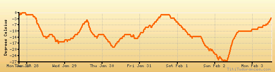
Temperature variation graph for the last seven days
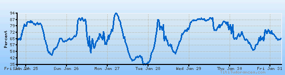
Humidity Variation Graph
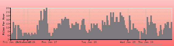
Wind speed
Weather Station: Caledonia County State Airport (latitude 44-34N, longitude 072-01W)
Local Time:
Lyndonville, Caledonia County is in the "America/New_York" timezone.
The "America/New_York" timezone uses a Standard Time (ST) / Daylight Saving Time (DST) alternation scheme, and it currently is in DST (since Sunday, 9 March 2025, 03:00 AM local time). During DST, the timezone abbreviation is EDT and the offset to Universal Time (UTC, GMT or Zulu) is -4:00 hours.
Lyndonville, Caledonia County will exit DST (returning to standard time) on Sunday, 2 November 2025, at 02:00 AM local time, when clocks will be turned backward 1 hour to Sunday, 2 November 2025, 01:00 AM local standard time. During ST, the timezone abbreviation is EST and the offset to UTC will be -5:00 hours.
Weather and Temperature in Vermont
Popular Weather Searches:
 If you own or manage a travel-related business such as a hotel, a bed-and-breakfast, a restaurant, a pub or a cafeteria, you can create a web page for your business for free on Titi Tudorancea Travel Info. » |