| Published in Weather / Utah Weather Temperature |
Weather in Logan, Utah
Current Conditions (Thursday, March 13, 2025 at 11:51 America/Denver time)
Temperature: 45°F (7°C) |
Forecast Overview
Fri Mar 14 
43°F 23°F 6°C -5°C Chance of heavy rain in the morning and in the afternoon. Chance of heavy snow in the afternoon.
detailsSat Mar 15 
32°F 19°F -0°C -7°C Chance of light snow at various times.
detailsSun Mar 16 32°F 25°F 0°C -4°C Chance of snow all day.
detailsMon Mar 17 41°F 27°F 5°C -3°C Chance of snow in the morning.
detailsTue Mar 18 
48°F 28°F 9°C -2°C Chance of snow after 6 pm.
detailsWed Mar 19 28°F 21°F -2°C -6°C Chance of snow until 3 pm.
detailsThu Mar 20 
32°F 14°F 0°C -10°C Chance of light snow late at night.
detailsFri Mar 21 32°F 21°F 0°C -6°C Chance of snow until 6 pm.
detailsSat Mar 22 39°F 19°F 4°C -7°C More clouds than sun.
details
Detailed Forecast
| Friday, March 14 | sunrise: 07:42 sunset: 19:31 |
| Low around 23°F (-5°C), high around 42°F (6°C). Chance of heavy rain during the morning and early afternoon (between 6 am and 3 pm). Chance of heavy snow late in the afternoon (between 3 pm and 6 pm). Estimated precipitation: 0.78 in (19.9375 mm). Overcast skies. Wind: 10 mph (16 km/h). |
| Time | Skies | Conditions | Temp | Wind | Humidity | Soil Moisture |
| 00:00 03:00 | Overcast. | 39°F (4°C) | 6 mph (9 km/h) | 68% | 0.372% | |
| 03:00 06:00 | Overcast. Precipitation: 0 in (0.0625 mm). | 38°F (3°C) | 5 mph (8 km/h) | 73% | 0.371% | |
| 06:00 09:00 | Chance of light rain. Precipitation: 0.03 in (0.6875 mm). | 36°F (2°C) | 6 mph (9 km/h) | 91% | 0.371% | |
| 09:00 12:00 | Chance of rain. Precipitation: 0.11 in (2.875 mm). | 39°F (4°C) | 10 mph (16 km/h) | 81% | 0.38% | |
| 12:00 15:00 | Chance of light rain. Precipitation: 0.03 in (0.8125 mm). | 41°F (5°C) | 7 mph (12 km/h) | 75% | 0.382% | |
| 15:00 18:00 | Chance of heavy snow. Precipitation: 0.45 in (11.5 mm). | 32°F (-0°C) | 9 mph (15 km/h) | 100% | 0.397% | |
| 18:00 21:00 | Overcast. Precipitation: 0.16 in (4 mm). | 26°F (-3°C) | 2 mph (3 km/h) | 97% | 0.381% | |
| 21:00 00:00 | Overcast. | 23°F (-5°C) | 1 mph (2 km/h) | 100% | 0.376% |
| Saturday, March 15 | sunrise: 07:41 sunset: 19:32 |
| Low around 20°F (-7°C), high around 32°F (-0°C). Chance of light snow before sunrise (between 3 am and 6 am) and again in the afternoon and evening (between 12 pm and 9 pm). Estimated precipitation: 0.08 in (2.0625 mm). Partly cloudy skies. Wind: 6 mph (10 km/h). |
| Time | Skies | Conditions | Temp | Wind | Humidity | Soil Moisture |
| 00:00 03:00 | Overcast. Precipitation: 0 in (0.0625 mm). | 23°F (-5°C) | 3 mph (4 km/h) | 98% | 0.373% | |
| 03:00 06:00 | Chance of light snow. Precipitation: 0 in (0.0625 mm). | 21°F (-6°C) | 2 mph (4 km/h) | 96% | 0.371% | |
| 06:00 09:00 | Considerable cloudiness. Precipitation: 0 in (0.125 mm). | 24°F (-5°C) | 1 mph (2 km/h) | 90% | 0.371% | |
| 09:00 12:00 | Sunny. Precipitation: 0.02 in (0.5625 mm). | 28°F (-2°C) | 5 mph (8 km/h) | 78% | 0.386% | |
| 12:00 15:00 | Chance of light snow. Precipitation: 0.02 in (0.625 mm). | 31°F (-1°C) | 6 mph (10 km/h) | 67% | 0.416% | |
| 15:00 18:00 | Chance of light snow. Precipitation: 0.01 in (0.3125 mm). | 31°F (-1°C) | 5 mph (8 km/h) | 62% | 0.418% | |
| 18:00 21:00 | Chance of light snow. Precipitation: 0 in (0.125 mm). | 26°F (-3°C) | 3 mph (5 km/h) | 84% | 0.413% | |
| 21:00 00:00 | Mostly cloudy. Precipitation: 0.01 in (0.1875 mm). | 27°F (-3°C) | 3 mph (5 km/h) | 89% | 0.41% |
| Sunday, March 16 | sunrise: 07:39 sunset: 19:33 |
| Low around 24°F (-4°C), high around 33°F (0°C). Chance of snow all day (from 3 am to midnight). The precipitation may fall as scattered showers of varying intensity. Estimated precipitation: 0.24 in (6.0625 mm). Overcast skies. Wind: 10 mph (17 km/h). |
| Time | Skies | Conditions | Temp | Wind | Humidity | Soil Moisture |
| 00:00 03:00 | Overcast. Precipitation: 0 in (0.125 mm). | 25°F (-4°C) | 3 mph (5 km/h) | 92% | 0.41% | |
| 03:00 06:00 | Chance of light snow. Precipitation: 0.03 in (0.75 mm). | 26°F (-4°C) | 5 mph (7 km/h) | 97% | 0.409% | |
| 06:00 09:00 | Chance of light snow. Precipitation: 0.03 in (0.8125 mm). | 26°F (-3°C) | 6 mph (9 km/h) | 92% | 0.41% | |
| 09:00 12:00 | Chance of snow. Precipitation: 0.04 in (1 mm). | 29°F (-2°C) | 8 mph (12 km/h) | 88% | 0.417% | |
| 12:00 15:00 | Chance of scattered snow showers. Precipitation: 0.07 in (1.6875 mm). | 32°F (0°C) | 10 mph (17 km/h) | 69% | 0.442% | |
| 15:00 18:00 | Chance of light snow. Precipitation: 0.03 in (0.8125 mm). | 32°F (-0°C) | 10 mph (16 km/h) | 68% | 0.437% | |
| 18:00 21:00 | Chance of light snow. Precipitation: 0.01 in (0.375 mm). | 29°F (-2°C) | 5 mph (8 km/h) | 79% | 0.429% | |
| 21:00 00:00 | Chance of light snow. Precipitation: 0.02 in (0.5 mm). | 28°F (-2°C) | 6 mph (9 km/h) | 92% | 0.424% |
| Monday, March 17 | sunrise: 07:37 sunset: 19:35 |
| Low around 27°F (-3°C), high around 40°F (5°C). Chance of snow all night and all morning (until 12 pm). Estimated precipitation: 0.37 in (9.3125 mm). Overcast skies. Wind: 8 mph (13 km/h). |
| Time | Skies | Conditions | Temp | Wind | Humidity | Soil Moisture |
| 00:00 03:00 | Chance of snow. Precipitation: 0.07 in (1.75 mm). | 28°F (-2°C) | 6 mph (10 km/h) | 99% | 0.422% | |
| 03:00 06:00 | Chance of snow. Precipitation: 0.08 in (2.125 mm). | 29°F (-2°C) | 7 mph (12 km/h) | 99% | 0.42% | |
| 06:00 09:00 | Chance of snow. Precipitation: 0.07 in (1.6875 mm). | 30°F (-1°C) | 7 mph (11 km/h) | 98% | 0.419% | |
| 09:00 12:00 | Chance of snow. Precipitation: 0.09 in (2.3125 mm). | 33°F (0°C) | 8 mph (13 km/h) | 100% | 0.427% | |
| 12:00 15:00 | Overcast. Precipitation: 0.05 in (1.375 mm). | 34°F (1°C) | 7 mph (11 km/h) | 100% | 0.434% | |
| 15:00 18:00 | More sun than clouds. Precipitation: 0 in (0.0625 mm). | 39°F (4°C) | 5 mph (8 km/h) | 89% | 0.429% | |
| 18:00 21:00 | Overcast. | 32°F (-0°C) | 8 mph (12 km/h) | 74% | 0.411% | |
| 21:00 00:00 | Overcast. | 36°F (2°C) | 7 mph (11 km/h) | 64% | 0.407% |
| Tuesday, March 18 | sunrise: 07:36 sunset: 19:36 |
| Low around 28°F (-2°C), high around 48°F (9°C). Chance of snow in the evening and during the night (after 6 pm). Estimated precipitation: 0.54 in (13.75 mm). Mostly cloudy skies. Wind: 9 mph (14 km/h). |
| Time | Skies | Conditions | Temp | Wind | Humidity | Soil Moisture |
| 00:00 03:00 | Overcast. | 36°F (2°C) | 5 mph (8 km/h) | 66% | 0.405% | |
| 03:00 06:00 | Overcast. | 31°F (-0°C) | 6 mph (10 km/h) | 66% | 0.403% | |
| 06:00 09:00 | Overcast. | 35°F (2°C) | 5 mph (9 km/h) | 69% | 0.402% | |
| 09:00 12:00 | Sunny. | 43°F (6°C) | 5 mph (8 km/h) | 70% | 0.403% | |
| 12:00 15:00 | A few passing clouds. Precipitation: 0 in (0.0625 mm). | 46°F (8°C) | 7 mph (12 km/h) | 59% | 0.399% | |
| 15:00 18:00 | Overcast. | 46°F (8°C) | 3 mph (5 km/h) | 67% | 0.398% | |
| 18:00 21:00 | Chance of snow. Precipitation: 0.35 in (8.9375 mm). | 30°F (-1°C) | 9 mph (14 km/h) | 99% | 0.403% | |
| 21:00 00:00 | Chance of snow. Precipitation: 0.19 in (4.75 mm). | 28°F (-2°C) | 9 mph (14 km/h) | 100% | 0.402% |
| Wednesday, March 19 | sunrise: 07:34 sunset: 19:37 |
| Low around 21°F (-6°C), high around 29°F (-2°C). Chance of snow during the morning and early afternoon (between 3 am and 3 pm). Estimated precipitation: 0.31 in (8 mm). Overcast skies. Wind: 9 mph (15 km/h). |
| Time | Skies | Conditions | Temp | Wind | Humidity | Soil Moisture |
| 00:00 03:00 | Overcast. Precipitation: 0.04 in (1.0625 mm). | 26°F (-3°C) | 4 mph (7 km/h) | 100% | 0.399% | |
| 03:00 06:00 | Chance of light snow. Precipitation: 0.01 in (0.375 mm). | 24°F (-4°C) | 5 mph (8 km/h) | 93% | 0.398% | |
| 06:00 09:00 | Chance of snow. Precipitation: 0.06 in (1.4375 mm). | 26°F (-3°C) | 8 mph (13 km/h) | 98% | 0.397% | |
| 09:00 12:00 | Chance of snow. Precipitation: 0.06 in (1.5625 mm). | 25°F (-4°C) | 9 mph (15 km/h) | 96% | 0.401% | |
| 12:00 15:00 | Chance of snow. Precipitation: 0.07 in (1.75 mm). | 27°F (-3°C) | 8 mph (13 km/h) | 99% | 0.41% | |
| 15:00 18:00 | Overcast. Precipitation: 0.04 in (1.125 mm). | 27°F (-3°C) | 6 mph (10 km/h) | 84% | 0.407% | |
| 18:00 21:00 | Overcast. Precipitation: 0.02 in (0.5625 mm). | 22°F (-5°C) | 1 mph (1 km/h) | 96% | 0.403% | |
| 21:00 00:00 | Overcast. Precipitation: 0 in (0.125 mm). | 21°F (-6°C) | 3 mph (5 km/h) | 89% | 0.401% |
| Thursday, March 20 | sunrise: 07:32 sunset: 19:38 |
| Low around 14°F (-10°C), high around 32°F (0°C). Chance of light snow late at night (after 9 pm). Estimated precipitation: 0 in (0.125 mm). Mostly cloudy skies. Wind: 7 mph (11 km/h). |
| Time | Skies | Conditions | Temp | Wind | Humidity | Soil Moisture |
| 00:00 03:00 | Mostly cloudy. | 19°F (-7°C) | 3 mph (5 km/h) | 84% | 0.4% | |
| 03:00 06:00 | Clear. | 15°F (-10°C) | 7 mph (11 km/h) | 83% | 0.4% | |
| 06:00 09:00 | Mostly sunny, with a few passing clouds. | 22°F (-5°C) | 4 mph (6 km/h) | 80% | 0.401% | |
| 09:00 12:00 | Overcast. | 29°F (-2°C) | 5 mph (8 km/h) | 80% | 0.41% | |
| 12:00 15:00 | Overcast. | 31°F (-1°C) | 5 mph (7 km/h) | 74% | 0.431% | |
| 15:00 18:00 | Overcast. | 32°F (-0°C) | 4 mph (6 km/h) | 71% | 0.436% | |
| 18:00 21:00 | Overcast. | 27°F (-3°C) | 6 mph (9 km/h) | 81% | 0.433% | |
| 21:00 00:00 | Chance of light snow. Precipitation: 0 in (0.125 mm). | 29°F (-2°C) | 4 mph (7 km/h) | 81% | 0.431% |
| Friday, March 21 | sunrise: 07:31 sunset: 19:39 |
| Low around 21°F (-6°C), high around 33°F (0°C). Chance of snow all morning and afternoon (between 3 am and 6 pm). Estimated precipitation: 0.18 in (4.5 mm). Overcast skies. Wind: 24 mph (39 km/h). |
| Time | Skies | Conditions | Temp | Wind | Humidity | Soil Moisture |
| 00:00 03:00 | Overcast. Precipitation: 0.01 in (0.375 mm). | 29°F (-2°C) | 7 mph (11 km/h) | 87% | 0.429% | |
| 03:00 06:00 | Chance of light snow. Precipitation: 0.02 in (0.5625 mm). | 27°F (-3°C) | 2 mph (3 km/h) | 91% | 0.428% | |
| 06:00 09:00 | Chance of light snow. Precipitation: 0 in (0.125 mm). | 31°F (-0°C) | 10 mph (16 km/h) | 86% | 0.426% | |
| 09:00 12:00 | Chance of snow. Precipitation: 0.1 in (2.5625 mm). | 30°F (-1°C) | 11 mph (18 km/h) | 94% | 0.435% | |
| 12:00 15:00 | Chance of light snow. Precipitation: 0.03 in (0.6875 mm). | 32°F (-0°C) | 24 mph (39 km/h) | 58% | 0.441% | |
| 15:00 18:00 | Chance of light snow. Precipitation: 0 in (0.125 mm). | 31°F (-0°C) | 16 mph (25 km/h) | 62% | 0.436% | |
| 18:00 21:00 | Mostly cloudy. Precipitation: 0 in (0.0625 mm). | 25°F (-4°C) | 2 mph (3 km/h) | 69% | 0.431% | |
| 21:00 00:00 | Overcast. | 21°F (-6°C) | 6 mph (10 km/h) | 73% | 0.429% |
| Saturday, March 22 | sunrise: 07:29 sunset: 19:40 |
| Low around 20°F (-7°C), high around 40°F (4°C). More clouds than sun. Wind: 9 mph (14 km/h). |
| Time | Skies | Conditions | Temp | Wind | Humidity | Soil Moisture |
| 00:00 03:00 | Overcast. | 20°F (-6°C) | 8 mph (12 km/h) | 72% | 0.428% | |
| 03:00 06:00 | Overcast. | 20°F (-7°C) | 7 mph (11 km/h) | 70% | 0.429% | |
| 06:00 09:00 | Overcast. | 27°F (-3°C) | 4 mph (7 km/h) | 61% | 0.43% | |
| 09:00 12:00 | Overcast. | 36°F (2°C) | 4 mph (6 km/h) | 56% | 0.431% | |
| 12:00 15:00 | Times of sun and clouds. | 39°F (4°C) | 4 mph (7 km/h) | 66% | 0.429% | |
| 15:00 18:00 | Sunny. | 39°F (4°C) | 4 mph (6 km/h) | 75% | 0.41% | |
| 18:00 21:00 | Clear. | 32°F (-0°C) | 8 mph (14 km/h) | 74% | 0.403% | |
| 21:00 00:00 | Clear. | 33°F (0°C) | 9 mph (14 km/h) | 70% | 0.401% |
Climate Chart
Places with a similar climate: Pocatello (ID), Idaho Falls (ID), Bozeman, Gallatin Field (MT).
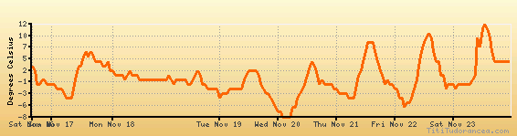
Temperature variation graph for the last seven days
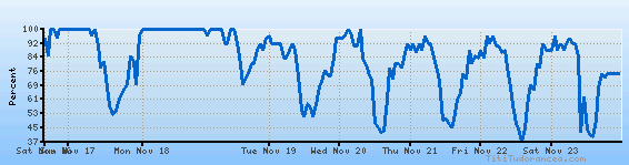
Humidity Variation Graph
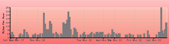
Wind speed
Weather Station: Logan, Logan-Cache Airport (latitude 41-46-58N, longitude 111-51-14W)
Local Time:
Logan is in the "America/Denver" timezone.
The "America/Denver" timezone uses a Standard Time (ST) / Daylight Saving Time (DST) alternation scheme, and it currently is in DST (since Sunday, 9 March 2025, 03:00 AM local time). During DST, the timezone abbreviation is MDT and the offset to Universal Time (UTC, GMT or Zulu) is -6:00 hours.
Logan will exit DST (returning to standard time) on Sunday, 2 November 2025, at 02:00 AM local time, when clocks will be turned backward 1 hour to Sunday, 2 November 2025, 01:00 AM local standard time. During ST, the timezone abbreviation is MST and the offset to UTC will be -7:00 hours.
Weather and Temperature in Utah
Popular Weather Searches:
 If you own or manage a travel-related business such as a hotel, a bed-and-breakfast, a restaurant, a pub or a cafeteria, you can create a web page for your business for free on Titi Tudorancea Travel Info. » |