| Published in Weather / New Hampshire Weather Temperature |
Weather in Lebanon, New Hampshire
Current Conditions (Sunday, February 2, 2025 at 05:53 America/New_York time)
Temperature: -11°F (-24°C) |
Forecast Overview
Sun Feb 2 
19°F -2°F -7°C -19°C Chance of snow after 7 pm.
detailsMon Feb 3 
36°F 10°F 2°C -12°C Chance of freezing rain in the afternoon and in the evening.
detailsTue Feb 4 
30°F 9°F -1°C -13°C Chance of light snow in the morning and in the afternoon.
detailsWed Feb 5 
18°F 1°F -8°C -17°C Times of sun and clouds.
detailsThu Feb 6 
23°F 5°F -5°C -15°C Chance of snow at various times.
detailsFri Feb 7 
34°F 3°F 1°C -16°C Chance of light snow in the morning.
detailsSat Feb 8 
23°F -0°F -5°C -18°C Mostly cloudy skies.
detailsSun Feb 9 
28°F 9°F -2°C -13°C Chance of snow in the morning.
detailsMon Feb 10 
21°F -4°F -6°C -20°C Chance of light snow after 7 pm.
details
Detailed Forecast
| Sunday, February 2 | sunrise: 07:06 sunset: 17:00 |
| Low around -3°F (-19°C), high around 19°F (-7°C). Chance of snow in the evening and during the night (after 7 pm). Estimated precipitation: 0.12 in (3.0625 mm). Overcast skies. Wind: 6 mph (10 km/h). |
| Time | Skies | Conditions | Temp | Wind | Humidity | Soil Moisture |
| 01:00 04:00 | Partly cloudy. | -2°F (-19°C) | 2 mph (4 km/h) | 95% | 0.426% | |
| 04:00 07:00 | Overcast. | -2°F (-19°C) | 1 mph (2 km/h) | 93% | 0.426% | |
| 07:00 10:00 | Overcast. | 8°F (-14°C) | 3 mph (5 km/h) | 67% | 0.427% | |
| 10:00 13:00 | Overcast. | 18°F (-8°C) | 6 mph (10 km/h) | 54% | 0.427% | |
| 13:00 16:00 | Overcast. | 18°F (-8°C) | 6 mph (10 km/h) | 72% | 0.427% | |
| 16:00 19:00 | Overcast. Precipitation: 0 in (0.0625 mm). | 17°F (-8°C) | 5 mph (9 km/h) | 87% | 0.427% | |
| 19:00 22:00 | Chance of snow. Precipitation: 0.05 in (1.375 mm). | 17°F (-8°C) | 4 mph (7 km/h) | 95% | 0.427% | |
| 22:00 01:00 | Chance of snow. Precipitation: 0.06 in (1.625 mm). | 18°F (-8°C) | 3 mph (5 km/h) | 96% | 0.427% |
| Monday, February 3 | sunrise: 07:05 sunset: 17:01 |
| Low around 10°F (-12°C), high around 35°F (2°C). Chance of freezing rain late in the afternoon and in the evening (between 4 pm and 10 pm). Estimated precipitation: 0.23 in (5.75 mm). Overcast skies. Wind: 4 mph (7 km/h). |
| Time | Skies | Conditions | Temp | Wind | Humidity | Soil Moisture |
| 01:00 04:00 | Considerable cloudiness. Precipitation: 0.02 in (0.5 mm). | 18°F (-8°C) | 2 mph (3 km/h) | 97% | 0.428% | |
| 04:00 07:00 | Overcast. | 11°F (-12°C) | 1 mph (2 km/h) | 99% | 0.428% | |
| 07:00 10:00 | Overcast. | 24°F (-5°C) | 3 mph (5 km/h) | 88% | 0.428% | |
| 10:00 13:00 | Overcast. | 33°F (1°C) | 3 mph (5 km/h) | 88% | 0.432% | |
| 13:00 16:00 | Overcast. | 34°F (1°C) | 4 mph (7 km/h) | 94% | 0.436% | |
| 16:00 19:00 | Possibly freezing rain leading to formation of glaze ice. Precipitation: 0.04 in (1.125 mm). | 31°F (-1°C) | 3 mph (5 km/h) | 99% | 0.44% | |
| 19:00 22:00 | Possibly freezing rain leading to formation of glaze ice. Precipitation: 0.15 in (3.875 mm). | 30°F (-1°C) | 2 mph (3 km/h) | 100% | 0.45% | |
| 22:00 01:00 | Mostly cloudy. Precipitation: 0.01 in (0.25 mm). | 30°F (-1°C) | 4 mph (6 km/h) | 97% | 0.45% |
| Tuesday, February 4 | sunrise: 07:03 sunset: 17:03 |
| Low around 9°F (-13°C), high around 30°F (-1°C). Chance of light snow in the morning and early afternoon (between 10 am and 4 pm). Estimated precipitation: 0.01 in (0.1875 mm). Partly cloudy skies. Wind: 15 mph (23 km/h). |
| Time | Skies | Conditions | Temp | Wind | Humidity | Soil Moisture |
| 01:00 04:00 | Mostly clear. | 26°F (-3°C) | 9 mph (15 km/h) | 78% | 0.45% | |
| 04:00 07:00 | Clear. | 19°F (-7°C) | 7 mph (12 km/h) | 78% | 0.45% | |
| 07:00 10:00 | Partly cloudy. | 24°F (-5°C) | 12 mph (20 km/h) | 73% | 0.45% | |
| 10:00 13:00 | Chance of light snow. Precipitation: 0 in (0.0625 mm). | 23°F (-5°C) | 15 mph (23 km/h) | 69% | 0.449% | |
| 13:00 16:00 | Chance of light snow. Precipitation: 0 in (0.0625 mm). | 17°F (-8°C) | 13 mph (20 km/h) | 73% | 0.448% | |
| 16:00 19:00 | Considerable cloudiness. Precipitation: 0 in (0.0625 mm). | 12°F (-11°C) | 11 mph (17 km/h) | 80% | 0.448% | |
| 19:00 22:00 | Partly cloudy. | 11°F (-12°C) | 9 mph (15 km/h) | 81% | 0.448% | |
| 22:00 01:00 | Considerable cloudiness. | 9°F (-13°C) | 8 mph (12 km/h) | 81% | 0.448% |
| Wednesday, February 5 | sunrise: 07:02 sunset: 17:04 |
| Low around 2°F (-17°C), high around 18°F (-8°C). Times of sun and clouds. Wind: 7 mph (11 km/h). |
| Time | Skies | Conditions | Temp | Wind | Humidity | Soil Moisture |
| 01:00 04:00 | Clear. | 6°F (-15°C) | 6 mph (9 km/h) | 86% | 0.448% | |
| 04:00 07:00 | Clear. | 2°F (-17°C) | 4 mph (6 km/h) | 95% | 0.449% | |
| 07:00 10:00 | Sunny. | 10°F (-12°C) | 7 mph (10 km/h) | 69% | 0.449% | |
| 10:00 13:00 | Sunny. | 17°F (-8°C) | 7 mph (11 km/h) | 56% | 0.449% | |
| 13:00 16:00 | Overcast. | 17°F (-8°C) | 5 mph (8 km/h) | 62% | 0.449% | |
| 16:00 19:00 | Clear. | 8°F (-14°C) | 2 mph (3 km/h) | 93% | 0.449% | |
| 19:00 22:00 | Overcast. | 5°F (-15°C) | 1 mph (2 km/h) | 96% | 0.449% | |
| 22:00 01:00 | Overcast. | 5°F (-15°C) | 1 mph (2 km/h) | 96% | 0.449% |
| Thursday, February 6 | sunrise: 07:01 sunset: 17:05 |
| Low around 5°F (-15°C), high around 23°F (-5°C). Chance of snow during the morning and early afternoon (between 4 am and 4 pm) and again at night (after 10 pm). Estimated precipitation: 0.3 in (7.5 mm). Overcast skies. Wind: 4 mph (6 km/h). |
| Time | Skies | Conditions | Temp | Wind | Humidity | Soil Moisture |
| 01:00 04:00 | Overcast. | 7°F (-14°C) | 1 mph (2 km/h) | 94% | 0.45% | |
| 04:00 07:00 | Chance of light snow. Precipitation: 0 in (0.125 mm). | 13°F (-11°C) | 3 mph (4 km/h) | 90% | 0.45% | |
| 07:00 10:00 | Chance of snow. Precipitation: 0.1 in (2.5625 mm). | 16°F (-9°C) | 4 mph (6 km/h) | 92% | 0.45% | |
| 10:00 13:00 | Chance of snow. Precipitation: 0.12 in (2.9375 mm). | 19°F (-7°C) | 4 mph (6 km/h) | 92% | 0.45% | |
| 13:00 16:00 | Chance of snow. Precipitation: 0.06 in (1.5625 mm). | 20°F (-7°C) | 3 mph (5 km/h) | 95% | 0.45% | |
| 16:00 19:00 | Overcast. Precipitation: 0.01 in (0.25 mm). | 21°F (-6°C) | 3 mph (5 km/h) | 96% | 0.45% | |
| 19:00 22:00 | Overcast. | 22°F (-6°C) | 3 mph (5 km/h) | 96% | 0.45% | |
| 22:00 01:00 | Chance of light snow. Precipitation: 0 in (0.0625 mm). | 23°F (-5°C) | 3 mph (5 km/h) | 97% | 0.45% |
| Friday, February 7 | sunrise: 07:00 sunset: 17:07 |
| Low around 3°F (-16°C), high around 35°F (1°C). Chance of light snow in the morning from 1 am to 4 am and from 10 am to 1 pm. Estimated precipitation: 0.02 in (0.4375 mm). Considerable cloudiness. Wind: 15 mph (24 km/h). |
| Time | Skies | Conditions | Temp | Wind | Humidity | Soil Moisture |
| 01:00 04:00 | Chance of light snow. Precipitation: 0.01 in (0.1875 mm). | 33°F (1°C) | 12 mph (20 km/h) | 85% | 0.45% | |
| 04:00 07:00 | Sunny. | 27°F (-3°C) | 15 mph (24 km/h) | 73% | 0.45% | |
| 07:00 10:00 | Considerable cloudiness. | 24°F (-4°C) | 15 mph (24 km/h) | 72% | 0.45% | |
| 10:00 13:00 | Chance of light snow. Precipitation: 0 in (0.125 mm). | 26°F (-3°C) | 14 mph (22 km/h) | 71% | 0.45% | |
| 13:00 16:00 | Mostly cloudy. Precipitation: 0 in (0.125 mm). | 22°F (-5°C) | 11 mph (18 km/h) | 73% | 0.449% | |
| 16:00 19:00 | Overcast. | 17°F (-9°C) | 7 mph (12 km/h) | 85% | 0.449% | |
| 19:00 22:00 | Mostly clear. | 8°F (-14°C) | 3 mph (5 km/h) | 95% | 0.449% | |
| 22:00 01:00 | Mostly cloudy. | 3°F (-16°C) | 2 mph (3 km/h) | 98% | 0.45% |
| Saturday, February 8 | sunrise: 06:59 sunset: 17:08 |
| Low around -0°F (-18°C), high around 24°F (-5°C). Mostly cloudy skies. Wind: 8 mph (13 km/h). |
| Time | Skies | Conditions | Temp | Wind | Humidity | Soil Moisture |
| 01:00 04:00 | Partly cloudy. | 1°F (-17°C) | 1 mph (1 km/h) | 98% | 0.45% | |
| 04:00 07:00 | More sun than clouds. | 0°F (-18°C) | 1 mph (1 km/h) | 99% | 0.45% | |
| 07:00 10:00 | Overcast. | 20°F (-7°C) | 8 mph (13 km/h) | 67% | 0.45% | |
| 10:00 13:00 | Overcast. | 23°F (-5°C) | 8 mph (13 km/h) | 60% | 0.45% | |
| 13:00 16:00 | Times of sun and clouds. | 22°F (-5°C) | 5 mph (9 km/h) | 70% | 0.45% | |
| 16:00 19:00 | Overcast. | 8°F (-13°C) | 2 mph (3 km/h) | 94% | 0.45% | |
| 19:00 22:00 | Overcast. | 14°F (-10°C) | 2 mph (3 km/h) | 93% | 0.45% | |
| 22:00 01:00 | Overcast. | 16°F (-9°C) | 2 mph (3 km/h) | 93% | 0.45% |
| Sunday, February 9 | sunrise: 06:57 sunset: 17:09 |
| Low around 8°F (-13°C), high around 28°F (-2°C). Chance of snow all night and all morning (until 1 pm). Estimated precipitation: 0.13 in (3.1875 mm). Considerable cloudiness. Wind: 9 mph (14 km/h). |
| Time | Skies | Conditions | Temp | Wind | Humidity | Soil Moisture |
| 01:00 04:00 | Chance of light snow. Precipitation: 0.01 in (0.25 mm). | 18°F (-8°C) | 2 mph (3 km/h) | 97% | 0.45% | |
| 04:00 07:00 | Chance of snow. Precipitation: 0.05 in (1.1875 mm). | 18°F (-8°C) | 2 mph (3 km/h) | 97% | 0.45% | |
| 07:00 10:00 | Chance of snow. Precipitation: 0.05 in (1.375 mm). | 22°F (-5°C) | 2 mph (3 km/h) | 92% | 0.45% | |
| 10:00 13:00 | Chance of light snow. Precipitation: 0.01 in (0.25 mm). | 27°F (-3°C) | 5 mph (8 km/h) | 78% | 0.451% | |
| 13:00 16:00 | Mostly sunny. Precipitation: 0 in (0.125 mm). | 27°F (-3°C) | 9 mph (14 km/h) | 75% | 0.45% | |
| 16:00 19:00 | Considerable cloudiness. | 14°F (-10°C) | 5 mph (7 km/h) | 93% | 0.45% | |
| 19:00 22:00 | Mostly clear. | 13°F (-10°C) | 7 mph (11 km/h) | 87% | 0.45% | |
| 22:00 01:00 | Partly cloudy. | 8°F (-13°C) | 5 mph (9 km/h) | 91% | 0.451% |
| Monday, February 10 | sunrise: 06:56 sunset: 17:11 |
| Low around -3°F (-20°C), high around 22°F (-6°C). Chance of light snow in the evening and during the night (after 7 pm). Estimated precipitation: 0.02 in (0.625 mm). Overcast skies. Wind: 3 mph (5 km/h). |
| Time | Skies | Conditions | Temp | Wind | Humidity | Soil Moisture |
| 01:00 04:00 | Partly cloudy. | -1°F (-18°C) | 3 mph (5 km/h) | 99% | 0.451% | |
| 04:00 07:00 | Overcast. | -3°F (-20°C) | 3 mph (5 km/h) | 100% | 0.451% | |
| 07:00 10:00 | Overcast. | 12°F (-11°C) | 2 mph (3 km/h) | 81% | 0.451% | |
| 10:00 13:00 | Overcast. | 21°F (-6°C) | 0 mph (1 km/h) | 68% | 0.451% | |
| 13:00 16:00 | Overcast. | 21°F (-6°C) | 3 mph (5 km/h) | 71% | 0.451% | |
| 16:00 19:00 | Overcast. | 16°F (-9°C) | 2 mph (3 km/h) | 95% | 0.451% | |
| 19:00 22:00 | Chance of light snow. Precipitation: 0 in (0.125 mm). | 18°F (-8°C) | 2 mph (4 km/h) | 96% | 0.451% | |
| 22:00 01:00 | Chance of light snow. Precipitation: 0.02 in (0.5 mm). | 18°F (-8°C) | 2 mph (4 km/h) | 96% | 0.451% |
Climate Chart
Places with a similar climate: Concord (NH), Orange (MA), Springfield (VT), Keene (NH), North Adams (MA), Elmira (NY), Sanford (ME), Bennington (VT), Rome (NY), Glens Falls (NY), Laconia (NH), Ithaca (NY), Pittsfield (MA), Jaffrey (NH), Caro, Tuscola Area (MI), Ann Arbor (MI), Alma, Gratiot (MI), Plattsburgh (NY), Rutland (VT), Flint (MI), Clearfield (PA), Wiscasset (ME), Monticello, Sullivan County (NY), Mount Pleasant (MI), St. Clair County (MI).
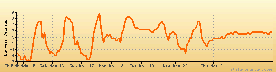
Temperature variation graph for the last seven days
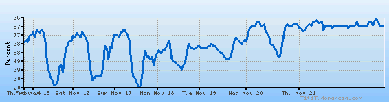
Humidity Variation Graph
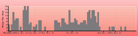
Wind speed
Weather Station: Lebanon, Lebanon Municipal Airport (latitude 43-37-38N, longitude 072-18-21W)
Local Time:
Lebanon is in the "America/New_York" timezone.
The "America/New_York" timezone uses a Standard Time (ST) / Daylight Saving Time (DST) alternation scheme, and it currently is in ST (since Sunday, 3 November 2024, 01:00 AM local time). During ST, the timezone abbreviation is EST and the offset to Universal Time (UTC, GMT or Zulu) is -5:00 hours.
Lebanon will exit standard time (entering DST) on Sunday, 9 March 2025, at 02:00 AM local time, when clocks will be turned forward 1 hour to Sunday, 9 March 2025, 03:00 AM local daylight time. During DST, the timezone abbreviation is EDT and the offset to UTC will be -4:00 hours.
Weather and Temperature in New Hampshire
Popular Weather Searches:
 If you own or manage a travel-related business such as a hotel, a bed-and-breakfast, a restaurant, a pub or a cafeteria, you can create a web page for your business for free on Titi Tudorancea Travel Info. » |