| Published in Weather / France Weather Temperature |
Weather in Le Puy, France
Current Conditions (Monday, February 3, 2025 at 09:00 Europe/Paris time)
Temperature: 25°F (-4°C) |
Forecast Overview
Tue Feb 4 
45°F 23°F 7°C -5°C Sunny skies.
detailsWed Feb 5 
48°F 25°F 9°C -4°C Mostly sunny, with a few passing clouds.
detailsThu Feb 6 46°F 27°F 8°C -3°C Sunny skies.
detailsFri Feb 7 
43°F 27°F 6°C -3°C Chance of light snow late at night.
detailsSat Feb 8 
32°F 23°F 0°C -5°C Chance of light snow at various times.
detailsSun Feb 9 
34°F 19°F 1°C -7°C Chance of light snow before sunrise.
detailsMon Feb 10 
37°F 23°F 3°C -5°C Mostly cloudy skies.
detailsTue Feb 11 43°F 23°F 6°C -5°C Mostly sunny.
detailsWed Feb 12 45°F 27°F 7°C -3°C A few passing clouds.
details
Detailed Forecast
| Tuesday, February 4 | sunrise: 08:03 sunset: 17:55 |
| Low around 23°F (-5°C), high around 45°F (7°C). Sunny skies. Wind: 6 mph (10 km/h). |
| Time | Skies | Conditions | Temp | Wind | Humidity | Soil Moisture |
| 01:00 04:00 | Partly cloudy. | 23°F (-5°C) | 3 mph (4 km/h) | 98% | 0.292% | |
| 04:00 07:00 | Mostly clear, with a few passing clouds. | 23°F (-5°C) | 3 mph (4 km/h) | 95% | 0.293% | |
| 07:00 10:00 | Sunny. | 32°F (0°C) | 4 mph (6 km/h) | 70% | 0.295% | |
| 10:00 13:00 | Sunny. | 43°F (6°C) | 6 mph (10 km/h) | 47% | 0.296% | |
| 13:00 16:00 | Sunny. | 44°F (7°C) | 5 mph (8 km/h) | 50% | 0.296% | |
| 16:00 19:00 | Clear. | 28°F (-2°C) | 2 mph (4 km/h) | 89% | 0.297% | |
| 19:00 22:00 | Clear. | 26°F (-4°C) | 1 mph (2 km/h) | 94% | 0.298% | |
| 22:00 01:00 | Mostly clear. | 25°F (-4°C) | 1 mph (2 km/h) | 94% | 0.299% |
| Wednesday, February 5 | sunrise: 08:02 sunset: 17:56 |
| Low around 25°F (-4°C), high around 48°F (9°C). Mostly sunny, with a few passing clouds. Wind: 3 mph (4 km/h). |
| Time | Skies | Conditions | Temp | Wind | Humidity | Soil Moisture |
| 01:00 04:00 | Partly cloudy. | 25°F (-4°C) | 2 mph (2 km/h) | 91% | 0.301% | |
| 04:00 07:00 | Overcast. | 25°F (-4°C) | 2 mph (3 km/h) | 87% | 0.302% | |
| 07:00 10:00 | Sunny. | 36°F (2°C) | 1 mph (1 km/h) | 61% | 0.304% | |
| 10:00 13:00 | Sunny. | 46°F (8°C) | 3 mph (4 km/h) | 40% | 0.306% | |
| 13:00 16:00 | Sunny. | 46°F (8°C) | 2 mph (3 km/h) | 46% | 0.305% | |
| 16:00 19:00 | Clear. | 32°F (0°C) | 1 mph (2 km/h) | 71% | 0.305% | |
| 19:00 22:00 | Clear. | 29°F (-2°C) | 2 mph (3 km/h) | 82% | 0.305% | |
| 22:00 01:00 | Clear. | 28°F (-2°C) | 2 mph (3 km/h) | 86% | 0.305% |
| Thursday, February 6 | sunrise: 08:00 sunset: 17:57 |
| Low around 26°F (-3°C), high around 46°F (8°C). Sunny skies. Wind: 8 mph (13 km/h). |
| Time | Skies | Conditions | Temp | Wind | Humidity | Soil Moisture |
| 01:00 04:00 | Clear. | 27°F (-3°C) | 2 mph (4 km/h) | 87% | 0.306% | |
| 04:00 07:00 | Clear. | 26°F (-3°C) | 4 mph (6 km/h) | 90% | 0.307% | |
| 07:00 10:00 | Sunny. | 33°F (1°C) | 5 mph (8 km/h) | 69% | 0.309% | |
| 10:00 13:00 | Sunny. | 44°F (7°C) | 8 mph (13 km/h) | 42% | 0.309% | |
| 13:00 16:00 | Sunny. | 43°F (6°C) | 8 mph (13 km/h) | 54% | 0.307% | |
| 16:00 19:00 | Clear. | 30°F (-1°C) | 5 mph (7 km/h) | 92% | 0.307% | |
| 19:00 22:00 | Mostly clear. | 28°F (-2°C) | 4 mph (6 km/h) | 96% | 0.307% | |
| 22:00 01:00 | Considerable cloudiness. | 27°F (-3°C) | 4 mph (6 km/h) | 98% | 0.307% |
| Friday, February 7 | sunrise: 07:59 sunset: 17:59 |
| Low around 27°F (-3°C), high around 42°F (6°C). Chance of light snow late at night (after 10 pm). Estimated precipitation: 0 in (0.0625 mm). Considerable cloudiness. Wind: 7 mph (12 km/h). |
| Time | Skies | Conditions | Temp | Wind | Humidity | Soil Moisture |
| 01:00 04:00 | Considerable cloudiness. | 28°F (-2°C) | 3 mph (5 km/h) | 97% | 0.308% | |
| 04:00 07:00 | Partly cloudy. | 28°F (-2°C) | 4 mph (6 km/h) | 94% | 0.308% | |
| 07:00 10:00 | Times of sun and clouds. | 31°F (-0°C) | 4 mph (7 km/h) | 84% | 0.309% | |
| 10:00 13:00 | Sunny. | 41°F (5°C) | 6 mph (9 km/h) | 55% | 0.309% | |
| 13:00 16:00 | Sunny. | 40°F (4°C) | 7 mph (12 km/h) | 61% | 0.307% | |
| 16:00 19:00 | Overcast. | 28°F (-2°C) | 4 mph (7 km/h) | 96% | 0.306% | |
| 19:00 22:00 | Overcast. | 31°F (-0°C) | 3 mph (5 km/h) | 91% | 0.305% | |
| 22:00 01:00 | Chance of light snow. Precipitation: 0 in (0.0625 mm). | 30°F (-1°C) | 3 mph (5 km/h) | 96% | 0.305% |
| Saturday, February 8 | sunrise: 07:58 sunset: 18:00 |
| Low around 23°F (-5°C), high around 32°F (0°C). Chance of light snow early in the morning (until 10 am) and in the evening (after 7 pm). Estimated precipitation: 0.09 in (2.3125 mm). Mostly cloudy skies. Wind: 7 mph (11 km/h). |
| Time | Skies | Conditions | Temp | Wind | Humidity | Soil Moisture |
| 01:00 04:00 | Chance of light snow. Precipitation: 0.02 in (0.4375 mm). | 29°F (-2°C) | 5 mph (8 km/h) | 96% | 0.305% | |
| 04:00 07:00 | Chance of light snow. Precipitation: 0.01 in (0.1875 mm). | 26°F (-3°C) | 5 mph (9 km/h) | 90% | 0.304% | |
| 07:00 10:00 | Chance of light snow. Precipitation: 0 in (0.125 mm). | 28°F (-2°C) | 3 mph (5 km/h) | 80% | 0.304% | |
| 10:00 13:00 | Overcast. Precipitation: 0 in (0.125 mm). | 32°F (-0°C) | 4 mph (6 km/h) | 68% | 0.304% | |
| 13:00 16:00 | Overcast. Precipitation: 0 in (0.125 mm). | 31°F (-1°C) | 7 mph (11 km/h) | 72% | 0.303% | |
| 16:00 19:00 | Clear. Precipitation: 0.01 in (0.3125 mm). | 25°F (-4°C) | 4 mph (6 km/h) | 92% | 0.303% | |
| 19:00 22:00 | Chance of light snow. Precipitation: 0.02 in (0.625 mm). | 25°F (-4°C) | 4 mph (6 km/h) | 96% | 0.304% | |
| 22:00 01:00 | Chance of light snow. Precipitation: 0.01 in (0.375 mm). | 23°F (-5°C) | 4 mph (6 km/h) | 95% | 0.305% |
| Sunday, February 9 | sunrise: 07:56 sunset: 18:02 |
| Low around 19°F (-7°C), high around 33°F (1°C). Chance of light snow before sunrise (between 4 am and 7 am). Estimated precipitation: 0.01 in (0.3125 mm). Mostly cloudy skies. Wind: 8 mph (13 km/h). |
| Time | Skies | Conditions | Temp | Wind | Humidity | Soil Moisture |
| 01:00 04:00 | Overcast. Precipitation: 0 in (0.125 mm). | 24°F (-5°C) | 5 mph (8 km/h) | 83% | 0.306% | |
| 04:00 07:00 | Chance of light snow. Precipitation: 0 in (0.0625 mm). | 24°F (-4°C) | 5 mph (8 km/h) | 80% | 0.307% | |
| 07:00 10:00 | Overcast. Precipitation: 0 in (0.0625 mm). | 26°F (-3°C) | 5 mph (8 km/h) | 71% | 0.308% | |
| 10:00 13:00 | Mostly sunny. | 31°F (-0°C) | 6 mph (10 km/h) | 59% | 0.309% | |
| 13:00 16:00 | More sun than clouds. | 32°F (-0°C) | 8 mph (13 km/h) | 57% | 0.309% | |
| 16:00 19:00 | Overcast. | 20°F (-7°C) | 3 mph (5 km/h) | 95% | 0.31% | |
| 19:00 22:00 | Mostly cloudy. | 19°F (-7°C) | 3 mph (5 km/h) | 98% | 0.312% | |
| 22:00 01:00 | Overcast. Precipitation: 0 in (0.0625 mm). | 23°F (-5°C) | 3 mph (5 km/h) | 89% | 0.314% |
| Monday, February 10 | sunrise: 07:55 sunset: 18:03 |
| Low around 23°F (-5°C), high around 37°F (3°C). Estimated precipitation: 0 in (0.0625 mm). Mostly cloudy skies. Wind: 4 mph (7 km/h). |
| Time | Skies | Conditions | Temp | Wind | Humidity | Soil Moisture |
| 01:00 04:00 | Overcast. | 24°F (-4°C) | 3 mph (5 km/h) | 84% | 0.316% | |
| 04:00 07:00 | Overcast. Precipitation: 0 in (0.0625 mm). | 24°F (-4°C) | 2 mph (3 km/h) | 83% | 0.317% | |
| 07:00 10:00 | Overcast. | 27°F (-3°C) | 2 mph (3 km/h) | 77% | 0.319% | |
| 10:00 13:00 | Overcast. | 34°F (1°C) | 2 mph (3 km/h) | 58% | 0.321% | |
| 13:00 16:00 | Overcast. | 36°F (2°C) | 4 mph (7 km/h) | 59% | 0.322% | |
| 16:00 19:00 | Overcast. | 26°F (-3°C) | 1 mph (2 km/h) | 88% | 0.323% | |
| 19:00 22:00 | Overcast. | 26°F (-4°C) | 2 mph (2 km/h) | 86% | 0.324% | |
| 22:00 01:00 | Clear. | 24°F (-4°C) | 2 mph (4 km/h) | 82% | 0.325% |
| Tuesday, February 11 | sunrise: 07:54 sunset: 18:05 |
| Low around 24°F (-5°C), high around 44°F (6°C). Estimated precipitation: 0 in (0.0625 mm). Mostly sunny. Wind: 5 mph (8 km/h). |
| Time | Skies | Conditions | Temp | Wind | Humidity | Soil Moisture |
| 01:00 04:00 | Partly cloudy. | 25°F (-4°C) | 3 mph (5 km/h) | 74% | 0.327% | |
| 04:00 07:00 | Clear. | 27°F (-3°C) | 2 mph (3 km/h) | 72% | 0.328% | |
| 07:00 10:00 | Partly cloudy. | 34°F (1°C) | 2 mph (4 km/h) | 62% | 0.33% | |
| 10:00 13:00 | Sunny. | 43°F (6°C) | 5 mph (8 km/h) | 51% | 0.331% | |
| 13:00 16:00 | Sunny. | 43°F (6°C) | 5 mph (8 km/h) | 53% | 0.33% | |
| 16:00 19:00 | Clear. Precipitation: 0 in (0.0625 mm). | 30°F (-1°C) | 3 mph (5 km/h) | 85% | 0.33% | |
| 19:00 22:00 | Clear. | 27°F (-3°C) | 3 mph (4 km/h) | 90% | 0.33% | |
| 22:00 01:00 | Clear. | 27°F (-3°C) | 2 mph (4 km/h) | 91% | 0.331% |
| Wednesday, February 12 | sunrise: 07:52 sunset: 18:06 |
| Low around 26°F (-3°C), high around 44°F (7°C). A few passing clouds. Wind: 6 mph (10 km/h). |
| Time | Skies | Conditions | Temp | Wind | Humidity | Soil Moisture |
| 01:00 04:00 | Clear. | 27°F (-3°C) | 3 mph (4 km/h) | 90% | 0.331% | |
| 04:00 07:00 | Clear. | 26°F (-3°C) | 2 mph (3 km/h) | 90% | 0.332% | |
| 07:00 10:00 | Sunny. | 35°F (2°C) | 1 mph (2 km/h) | 69% | 0.333% | |
| 10:00 13:00 | More sun than clouds. | 43°F (6°C) | 2 mph (3 km/h) | 50% | 0.333% | |
| 13:00 16:00 | More clouds than sun. | 43°F (6°C) | 3 mph (5 km/h) | 53% | 0.332% | |
| 16:00 19:00 | Clear. | 30°F (-1°C) | 5 mph (8 km/h) | 88% | 0.33% | |
| 19:00 22:00 | Overcast. | 29°F (-2°C) | 6 mph (9 km/h) | 95% | 0.328% | |
| 22:00 01:00 | A few passing clouds. | 29°F (-1°C) | 6 mph (10 km/h) | 90% | 0.327% |
Climate Chart
Places with a similar climate: Fritzlar (Germany), Ramstein (Germany), Bremen (Germany), Augsburg (Germany), Deelen (Netherlands), Fassberg (Germany), Hannover (Germany), Saarbruecken / Ensheim (Germany), Volkel (Netherlands), Illesheim (Germany), Laage (Germany), Spangdahlem (Germany), Schleswig-Jagel (Germany), Stuttgart-Echterdingen (Germany), Erfurt-Bindersleben (Germany), Groningen (Netherlands), Muenster / Osnabrueck (Germany), Hohn (Germany), Nuernberg (Germany), Landsberg (Germany), Nancy / Ochey, Guetersloh (Germany), Paderborn / Lippstadt (Germany), Aurillac, Munchen (Germany).
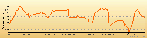
Temperature variation graph for the last seven days
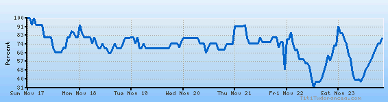
Humidity Variation Graph
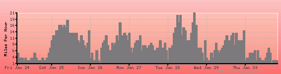
Wind speed
Weather Station: Le Puy (latitude 45-05N, longitude 003-46E)
Local Time:
Le Puy is in the "Europe/Paris" timezone.
The "Europe/Paris" timezone uses a Standard Time (ST) / Daylight Saving Time (DST) alternation scheme, and it currently is in ST (since Sunday, 27 October 2024, 02:00 AM local time). During ST, the timezone abbreviation is CET and the offset to Universal Time (UTC, GMT or Zulu) is +1:00 hours.
Le Puy will exit standard time (entering DST) on Sunday, 30 March 2025, at 02:00 AM local time, when clocks will be turned forward 1 hour to Sunday, 30 March 2025, 03:00 AM local daylight time. During DST, the timezone abbreviation is CEST and the offset to UTC will be +2:00 hours.
Weather and Temperature in France
Popular Weather Searches:
 If you own or manage a travel-related business such as a hotel, a bed-and-breakfast, a restaurant, a pub or a cafeteria, you can create a web page for your business for free on Titi Tudorancea Travel Info. » |