| Published in Weather / Nebraska Weather Temperature |
Weather in Kearney, Nebraska
Current Conditions (Thursday, March 13, 2025 at 11:56 America/Chicago time)
Temperature: 70°F (21°C) |
Forecast Overview
Fri Mar 14 
73°F 48°F 23°C 9°C Sunny skies.
detailsSat Mar 15 
68°F 43°F 20°C 6°C Chance of light rain in the afternoon.
detailsSun Mar 16 
52°F 37°F 11°C 3°C Times of sun and clouds.
detailsMon Mar 17 61°F 36°F 16°C 2°C Times of sun and clouds.
detailsTue Mar 18 77°F 45°F 25°C 7°C More sun than clouds.
detailsWed Mar 19 
75°F 28°F 24°C -2°C Chance of snow after 7 pm.
detailsThu Mar 20 
48°F 27°F 9°C -3°C Chance of light snow before sunrise.
detailsFri Mar 21 
63°F 34°F 17°C 1°C Mostly cloudy skies.
detailsSat Mar 22 
48°F 32°F 9°C -0°C A few passing clouds.
details
Detailed Forecast
| Friday, March 14 | sunrise: 07:51 sunset: 19:40 |
| Low around 48°F (9°C), high around 74°F (23°C). Sunny skies. Wind: 19 mph (30 km/h). |
| Time | Skies | Conditions | Temp | Wind | Humidity | Soil Moisture |
| 01:00 04:00 | Clear. | 50°F (10°C) | 7 mph (11 km/h) | 42% | 0.16% | |
| 04:00 07:00 | Clear. | 48°F (9°C) | 7 mph (11 km/h) | 47% | 0.16% | |
| 07:00 10:00 | Sunny. | 57°F (14°C) | 10 mph (16 km/h) | 37% | 0.16% | |
| 10:00 13:00 | Sunny. | 71°F (21°C) | 15 mph (24 km/h) | 20% | 0.158% | |
| 13:00 16:00 | Sunny. | 74°F (23°C) | 19 mph (30 km/h) | 16% | 0.156% | |
| 16:00 19:00 | Mostly sunny. | 69°F (21°C) | 15 mph (24 km/h) | 25% | 0.155% | |
| 19:00 22:00 | A few passing clouds. | 60°F (16°C) | 14 mph (22 km/h) | 44% | 0.154% | |
| 22:00 01:00 | Clear. | 58°F (15°C) | 16 mph (26 km/h) | 51% | 0.154% |
| Saturday, March 15 | sunrise: 07:49 sunset: 19:41 |
| Low around 42°F (6°C), high around 68°F (20°C). Chance of light rain late in the afternoon (between 4 pm and 7 pm). Estimated precipitation: 0.03 in (0.6875 mm). Mostly cloudy skies. Wind: 29 mph (46 km/h). |
| Time | Skies | Conditions | Temp | Wind | Humidity | Soil Moisture |
| 01:00 04:00 | Overcast. | 56°F (13°C) | 14 mph (23 km/h) | 45% | 0.153% | |
| 04:00 07:00 | Overcast. | 53°F (11°C) | 10 mph (17 km/h) | 39% | 0.153% | |
| 07:00 10:00 | Overcast. | 58°F (14°C) | 13 mph (22 km/h) | 36% | 0.153% | |
| 10:00 13:00 | Sunny. Precipitation: 0.01 in (0.1875 mm). | 65°F (18°C) | 12 mph (19 km/h) | 30% | 0.152% | |
| 13:00 16:00 | Mostly cloudy. | 67°F (20°C) | 4 mph (7 km/h) | 25% | 0.15% | |
| 16:00 19:00 | Chance of light rain. Precipitation: 0.01 in (0.25 mm). | 55°F (13°C) | 29 mph (46 km/h) | 60% | 0.153% | |
| 19:00 22:00 | Overcast. Precipitation: 0.01 in (0.25 mm). | 46°F (8°C) | 27 mph (44 km/h) | 67% | 0.155% | |
| 22:00 01:00 | Overcast. | 42°F (6°C) | 26 mph (41 km/h) | 63% | 0.154% |
| Sunday, March 16 | sunrise: 07:48 sunset: 19:42 |
| Low around 37°F (3°C), high around 51°F (11°C). Times of sun and clouds. Wind: 26 mph (43 km/h). |
| Time | Skies | Conditions | Temp | Wind | Humidity | Soil Moisture |
| 01:00 04:00 | Overcast. | 42°F (5°C) | 26 mph (43 km/h) | 56% | 0.154% | |
| 04:00 07:00 | Clear. | 38°F (4°C) | 22 mph (36 km/h) | 45% | 0.153% | |
| 07:00 10:00 | Overcast. | 40°F (5°C) | 21 mph (33 km/h) | 29% | 0.153% | |
| 10:00 13:00 | Overcast. | 47°F (8°C) | 20 mph (33 km/h) | 21% | 0.152% | |
| 13:00 16:00 | Sunny. | 51°F (11°C) | 19 mph (31 km/h) | 20% | 0.15% | |
| 16:00 19:00 | Sunny. | 48°F (9°C) | 15 mph (23 km/h) | 26% | 0.149% | |
| 19:00 22:00 | Clear. | 41°F (5°C) | 7 mph (12 km/h) | 37% | 0.149% | |
| 22:00 01:00 | Clear. | 38°F (3°C) | 5 mph (8 km/h) | 42% | 0.148% |
| Monday, March 17 | sunrise: 07:46 sunset: 19:43 |
| Low around 36°F (2°C), high around 60°F (16°C). Times of sun and clouds. Wind: 17 mph (27 km/h). |
| Time | Skies | Conditions | Temp | Wind | Humidity | Soil Moisture |
| 01:00 04:00 | Overcast. | 36°F (2°C) | 4 mph (7 km/h) | 45% | 0.149% | |
| 04:00 07:00 | Overcast. | 37°F (3°C) | 4 mph (6 km/h) | 42% | 0.149% | |
| 07:00 10:00 | Sunny. | 43°F (6°C) | 11 mph (18 km/h) | 36% | 0.148% | |
| 10:00 13:00 | Sunny. | 57°F (14°C) | 16 mph (26 km/h) | 21% | 0.147% | |
| 13:00 16:00 | More clouds than sun. | 60°F (16°C) | 17 mph (27 km/h) | 16% | 0.145% | |
| 16:00 19:00 | Partly cloudy. | 57°F (14°C) | 3 mph (4 km/h) | 25% | 0.144% | |
| 19:00 22:00 | Clear. | 50°F (10°C) | 8 mph (14 km/h) | 33% | 0.144% | |
| 22:00 01:00 | Clear. | 50°F (10°C) | 10 mph (16 km/h) | 33% | 0.144% |
| Tuesday, March 18 | sunrise: 07:44 sunset: 19:44 |
| Low around 45°F (7°C), high around 77°F (25°C). More sun than clouds. Wind: 15 mph (24 km/h). |
| Time | Skies | Conditions | Temp | Wind | Humidity | Soil Moisture |
| 01:00 04:00 | Clear. | 47°F (8°C) | 9 mph (15 km/h) | 46% | 0.144% | |
| 04:00 07:00 | Clear. | 46°F (8°C) | 9 mph (14 km/h) | 50% | 0.144% | |
| 07:00 10:00 | Sunny. | 58°F (14°C) | 9 mph (14 km/h) | 32% | 0.144% | |
| 10:00 13:00 | Sunny. | 71°F (22°C) | 12 mph (19 km/h) | 17% | 0.142% | |
| 13:00 16:00 | A few passing clouds. | 77°F (25°C) | 11 mph (18 km/h) | 11% | 0.141% | |
| 16:00 19:00 | Overcast. | 70°F (21°C) | 14 mph (22 km/h) | 19% | 0.14% | |
| 19:00 22:00 | Overcast. | 63°F (17°C) | 15 mph (24 km/h) | 30% | 0.139% | |
| 22:00 01:00 | Partly cloudy. | 59°F (15°C) | 12 mph (19 km/h) | 41% | 0.139% |
| Wednesday, March 19 | sunrise: 07:43 sunset: 19:45 |
| Low around 29°F (-2°C), high around 75°F (24°C). Chance of snow in the evening and during the night (after 7 pm). Estimated precipitation: 0.09 in (2.25 mm). Mostly cloudy skies. Wind: 27 mph (44 km/h). |
| Time | Skies | Conditions | Temp | Wind | Humidity | Soil Moisture |
| 01:00 04:00 | Clear. | 58°F (14°C) | 12 mph (19 km/h) | 30% | 0.138% | |
| 04:00 07:00 | Overcast. | 53°F (12°C) | 7 mph (12 km/h) | 31% | 0.138% | |
| 07:00 10:00 | Overcast. | 62°F (16°C) | 10 mph (17 km/h) | 26% | 0.138% | |
| 10:00 13:00 | Sunny. | 73°F (23°C) | 17 mph (27 km/h) | 19% | 0.137% | |
| 13:00 16:00 | Overcast. | 73°F (23°C) | 19 mph (30 km/h) | 16% | 0.135% | |
| 16:00 19:00 | Overcast. Precipitation: 0.01 in (0.25 mm). | 50°F (10°C) | 27 mph (44 km/h) | 53% | 0.136% | |
| 19:00 22:00 | Chance of snow. Precipitation: 0.04 in (1.0625 mm). | 34°F (1°C) | 22 mph (36 km/h) | 87% | 0.14% | |
| 22:00 01:00 | Chance of light snow. Precipitation: 0.04 in (0.9375 mm). | 29°F (-2°C) | 24 mph (38 km/h) | 88% | 0.141% |
| Thursday, March 20 | sunrise: 07:41 sunset: 19:46 |
| Low around 26°F (-3°C), high around 48°F (9°C). Chance of light snow between 1 am and 4 am. Estimated precipitation: 0.04 in (1.125 mm). More sun than clouds. Wind: 26 mph (42 km/h). |
| Time | Skies | Conditions | Temp | Wind | Humidity | Soil Moisture |
| 01:00 04:00 | Chance of snow. Precipitation: 0.04 in (1 mm). | 27°F (-3°C) | 26 mph (42 km/h) | 90% | 0.141% | |
| 04:00 07:00 | Overcast. Precipitation: 0 in (0.125 mm). | 27°F (-3°C) | 20 mph (32 km/h) | 62% | 0.141% | |
| 07:00 10:00 | Overcast. | 30°F (-1°C) | 15 mph (25 km/h) | 58% | 0.14% | |
| 10:00 13:00 | Sunny. | 39°F (4°C) | 13 mph (21 km/h) | 40% | 0.147% | |
| 13:00 16:00 | Considerable cloudiness. | 46°F (8°C) | 14 mph (22 km/h) | 32% | 0.15% | |
| 16:00 19:00 | Sunny. | 47°F (8°C) | 8 mph (13 km/h) | 34% | 0.151% | |
| 19:00 22:00 | Clear. | 39°F (4°C) | 4 mph (6 km/h) | 45% | 0.151% | |
| 22:00 01:00 | Clear. | 37°F (3°C) | 6 mph (9 km/h) | 45% | 0.151% |
| Friday, March 21 | sunrise: 07:39 sunset: 19:47 |
| Low around 34°F (1°C), high around 62°F (17°C). Mostly cloudy skies. Wind: 18 mph (29 km/h). |
| Time | Skies | Conditions | Temp | Wind | Humidity | Soil Moisture |
| 01:00 04:00 | Overcast. | 35°F (2°C) | 8 mph (13 km/h) | 47% | 0.151% | |
| 04:00 07:00 | Clear. | 34°F (1°C) | 9 mph (14 km/h) | 51% | 0.151% | |
| 07:00 10:00 | Overcast. | 45°F (7°C) | 15 mph (24 km/h) | 42% | 0.151% | |
| 10:00 13:00 | Overcast. | 56°F (13°C) | 18 mph (29 km/h) | 24% | 0.152% | |
| 13:00 16:00 | Overcast. | 62°F (17°C) | 12 mph (19 km/h) | 19% | 0.15% | |
| 16:00 19:00 | Mostly cloudy. | 59°F (15°C) | 3 mph (5 km/h) | 25% | 0.15% | |
| 19:00 22:00 | Overcast. | 52°F (11°C) | 8 mph (12 km/h) | 37% | 0.15% | |
| 22:00 01:00 | Overcast. | 46°F (8°C) | 13 mph (21 km/h) | 50% | 0.149% |
| Saturday, March 22 | sunrise: 07:38 sunset: 19:49 |
| Low around 32°F (-0°C), high around 48°F (9°C). Estimated precipitation: 0 in (0.0625 mm). A few passing clouds. Wind: 20 mph (33 km/h). |
| Time | Skies | Conditions | Temp | Wind | Humidity | Soil Moisture |
| 01:00 04:00 | Overcast. | 40°F (4°C) | 17 mph (27 km/h) | 74% | 0.149% | |
| 04:00 07:00 | Overcast. Precipitation: 0 in (0.0625 mm). | 35°F (1°C) | 20 mph (33 km/h) | 76% | 0.149% | |
| 07:00 10:00 | Sunny. | 34°F (1°C) | 18 mph (29 km/h) | 52% | 0.149% | |
| 10:00 13:00 | Sunny. | 43°F (6°C) | 14 mph (23 km/h) | 29% | 0.148% | |
| 13:00 16:00 | Sunny. | 48°F (9°C) | 11 mph (18 km/h) | 28% | 0.146% | |
| 16:00 19:00 | Sunny. | 46°F (8°C) | 6 mph (10 km/h) | 30% | 0.145% | |
| 19:00 22:00 | Clear. | 38°F (3°C) | 8 mph (12 km/h) | 36% | 0.145% | |
| 22:00 01:00 | Clear. | 36°F (2°C) | 10 mph (16 km/h) | 37% | 0.145% |
Climate Chart
Places with a similar climate: Grand Island (NE), Hastings (NE), Aurora (NE), York (NE), Holdrege (NE), Lexington (NE), Columbus (NE), Albion (NE), Beatrice (NE), Hebron (NE), Fremont (NE), Ord (NE), Thedford, Thomas County (NE), Lincoln (NE), Nebraska City (NE), Clarinda (IA), Norfolk (NE), Red Oak (IA), McCook (NE), Atlantic (IA), Broken Bow (NE), Omaha (NE), Shenandoah (IA), Creston (IA), Omaha (NE).
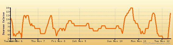
Temperature variation graph for the last seven days
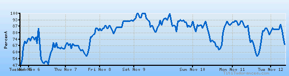
Humidity Variation Graph
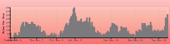
Wind speed
Weather Station: Kearney, Kearney Municipal Airport (latitude 40-44N, longitude 099-00W)
Local Time:
Kearney is in the "America/Chicago" timezone.
The "America/Chicago" timezone uses a Standard Time (ST) / Daylight Saving Time (DST) alternation scheme, and it currently is in DST (since Sunday, 9 March 2025, 03:00 AM local time). During DST, the timezone abbreviation is CDT and the offset to Universal Time (UTC, GMT or Zulu) is -5:00 hours.
Kearney will exit DST (returning to standard time) on Sunday, 2 November 2025, at 02:00 AM local time, when clocks will be turned backward 1 hour to Sunday, 2 November 2025, 01:00 AM local standard time. During ST, the timezone abbreviation is CST and the offset to UTC will be -6:00 hours.
Weather and Temperature in Nebraska
Popular Weather Searches:
 If you own or manage a travel-related business such as a hotel, a bed-and-breakfast, a restaurant, a pub or a cafeteria, you can create a web page for your business for free on Titi Tudorancea Travel Info. » |