| Published in Weather / Maine Weather Temperature |
Weather in Houlton, Maine
Current Conditions (Friday, March 14, 2025 at 04:53 America/New_York time)
Temperature: 25°F (-4°C) |
Forecast Overview
Fri Mar 14 
46°F 23°F 8°C -5°C More clouds than sun.
detailsSat Mar 15 
52°F 27°F 11°C -3°C Mostly cloudy skies.
detailsSun Mar 16 54°F 37°F 12°C 3°C Overcast skies.
detailsMon Mar 17 
55°F 37°F 13°C 3°C Chance of rain all day.
detailsTue Mar 18 50°F 30°F 10°C -1°C More clouds than sun.
detailsWed Mar 19 59°F 34°F 15°C 1°C Considerable cloudiness.
detailsThu Mar 20 54°F 39°F 12°C 4°C Overcast skies.
detailsFri Mar 21 
54°F 32°F 12°C -0°C Chance of rain in the morning and in the afternoon. Chance of snow after 5 pm.
detailsSat Mar 22 36°F 28°F 2°C -2°C Partly cloudy skies.
details
Detailed Forecast
| Friday, March 14 | sunrise: 06:48 sunset: 18:33 |
| Low around 24°F (-5°C), high around 46°F (8°C). More clouds than sun. Wind: 9 mph (14 km/h). |
| Time | Skies | Conditions | Temp | Wind | Humidity | Soil Moisture |
| 23:00 02:00 | Clear. | 24°F (-5°C) | 9 mph (14 km/h) | 84% | 0.444% | |
| 02:00 05:00 | Times of clear skies and clouds. | 25°F (-4°C) | 8 mph (13 km/h) | 86% | 0.444% | |
| 05:00 08:00 | Overcast. | 27°F (-3°C) | 7 mph (12 km/h) | 87% | 0.444% | |
| 08:00 11:00 | Sunny. | 37°F (3°C) | 7 mph (12 km/h) | 70% | 0.444% | |
| 11:00 14:00 | Mostly sunny. | 45°F (7°C) | 9 mph (14 km/h) | 62% | 0.444% | |
| 14:00 17:00 | Overcast. | 43°F (6°C) | 5 mph (9 km/h) | 76% | 0.444% | |
| 17:00 20:00 | Mostly clear. | 31°F (-1°C) | 2 mph (4 km/h) | 95% | 0.442% | |
| 20:00 23:00 | Overcast. | 29°F (-2°C) | 2 mph (3 km/h) | 97% | 0.441% |
| Saturday, March 15 | sunrise: 06:46 sunset: 18:35 |
| Low around 27°F (-3°C), high around 52°F (11°C). Mostly cloudy skies. Wind: 11 mph (18 km/h). |
| Time | Skies | Conditions | Temp | Wind | Humidity | Soil Moisture |
| 23:00 02:00 | Mostly clear, with a few passing clouds. | 28°F (-2°C) | 2 mph (3 km/h) | 98% | 0.44% | |
| 02:00 05:00 | Overcast. | 27°F (-3°C) | 2 mph (3 km/h) | 98% | 0.44% | |
| 05:00 08:00 | Overcast. | 32°F (0°C) | 3 mph (5 km/h) | 90% | 0.439% | |
| 08:00 11:00 | Overcast. | 44°F (7°C) | 9 mph (15 km/h) | 77% | 0.44% | |
| 11:00 14:00 | Considerable cloudiness. | 52°F (11°C) | 11 mph (17 km/h) | 71% | 0.438% | |
| 14:00 17:00 | Overcast. | 48°F (9°C) | 11 mph (17 km/h) | 81% | 0.431% | |
| 17:00 20:00 | Partly cloudy. | 41°F (5°C) | 11 mph (18 km/h) | 93% | 0.417% | |
| 20:00 23:00 | Overcast. | 37°F (3°C) | 10 mph (16 km/h) | 97% | 0.402% |
| Sunday, March 16 | sunrise: 06:44 sunset: 18:36 |
| Low around 37°F (3°C), high around 54°F (12°C). Overcast skies. Wind: 17 mph (27 km/h). |
| Time | Skies | Conditions | Temp | Wind | Humidity | Soil Moisture |
| 23:00 02:00 | Overcast. | 37°F (3°C) | 7 mph (11 km/h) | 96% | 0.39% | |
| 02:00 05:00 | Overcast. | 38°F (4°C) | 9 mph (14 km/h) | 97% | 0.379% | |
| 05:00 08:00 | Overcast. | 43°F (6°C) | 11 mph (17 km/h) | 98% | 0.368% | |
| 08:00 11:00 | Overcast. | 50°F (10°C) | 14 mph (22 km/h) | 95% | 0.352% | |
| 11:00 14:00 | Overcast. | 49°F (10°C) | 13 mph (21 km/h) | 97% | 0.339% | |
| 14:00 17:00 | Overcast. | 54°F (12°C) | 15 mph (25 km/h) | 90% | 0.33% | |
| 17:00 20:00 | Overcast. | 53°F (12°C) | 16 mph (25 km/h) | 93% | 0.323% | |
| 20:00 23:00 | Overcast. | 53°F (12°C) | 17 mph (27 km/h) | 96% | 0.319% |
| Monday, March 17 | sunrise: 06:42 sunset: 18:38 |
| Low around 37°F (3°C), high around 55°F (13°C). Chance of rain most of the day (from 5 am to 8 pm). Estimated precipitation: 0.81 in (20.5 mm). Overcast skies. Wind: 18 mph (29 km/h). |
| Time | Skies | Conditions | Temp | Wind | Humidity | Soil Moisture |
| 23:00 02:00 | Overcast. | 54°F (12°C) | 18 mph (29 km/h) | 96% | 0.315% | |
| 02:00 05:00 | Overcast. | 54°F (12°C) | 18 mph (29 km/h) | 93% | 0.313% | |
| 05:00 08:00 | Chance of rain. Precipitation: 0.07 in (1.6875 mm). | 52°F (11°C) | 9 mph (15 km/h) | 96% | 0.321% | |
| 08:00 11:00 | Chance of rain. Precipitation: 0.09 in (2.375 mm). | 51°F (11°C) | 7 mph (12 km/h) | 95% | 0.332% | |
| 11:00 14:00 | Chance of rain. Precipitation: 0.23 in (5.875 mm). | 50°F (10°C) | 3 mph (5 km/h) | 98% | 0.359% | |
| 14:00 17:00 | Chance of rain. Precipitation: 0.29 in (7.4375 mm). | 45°F (7°C) | 7 mph (11 km/h) | 96% | 0.377% | |
| 17:00 20:00 | Chance of rain. Precipitation: 0.11 in (2.8125 mm). | 42°F (6°C) | 9 mph (14 km/h) | 93% | 0.363% | |
| 20:00 23:00 | Overcast. Precipitation: 0.01 in (0.3125 mm). | 37°F (3°C) | 8 mph (13 km/h) | 86% | 0.345% |
| Tuesday, March 18 | sunrise: 06:40 sunset: 18:39 |
| Low around 30°F (-1°C), high around 49°F (10°C). More clouds than sun. Wind: 7 mph (12 km/h). |
| Time | Skies | Conditions | Temp | Wind | Humidity | Soil Moisture |
| 23:00 02:00 | Times of clear skies and clouds. | 35°F (2°C) | 7 mph (12 km/h) | 84% | 0.333% | |
| 02:00 05:00 | Overcast. | 31°F (-1°C) | 5 mph (7 km/h) | 91% | 0.324% | |
| 05:00 08:00 | Overcast. | 33°F (1°C) | 4 mph (6 km/h) | 80% | 0.321% | |
| 08:00 11:00 | Overcast. | 42°F (5°C) | 2 mph (4 km/h) | 61% | 0.316% | |
| 11:00 14:00 | Sunny. | 48°F (9°C) | 6 mph (10 km/h) | 51% | 0.306% | |
| 14:00 17:00 | Sunny. | 49°F (9°C) | 7 mph (11 km/h) | 56% | 0.298% | |
| 17:00 20:00 | Mostly clear. | 40°F (4°C) | 4 mph (7 km/h) | 79% | 0.295% | |
| 20:00 23:00 | Mostly cloudy. | 41°F (5°C) | 4 mph (6 km/h) | 83% | 0.292% |
| Wednesday, March 19 | sunrise: 06:38 sunset: 18:40 |
| Low around 34°F (1°C), high around 59°F (15°C). Considerable cloudiness. Wind: 10 mph (16 km/h). |
| Time | Skies | Conditions | Temp | Wind | Humidity | Soil Moisture |
| 23:00 02:00 | Clear. | 37°F (3°C) | 4 mph (6 km/h) | 90% | 0.29% | |
| 02:00 05:00 | Overcast. | 34°F (1°C) | 3 mph (4 km/h) | 91% | 0.288% | |
| 05:00 08:00 | Considerable cloudiness. | 37°F (3°C) | 1 mph (2 km/h) | 83% | 0.287% | |
| 08:00 11:00 | Sunny. | 47°F (8°C) | 4 mph (6 km/h) | 57% | 0.283% | |
| 11:00 14:00 | Overcast. | 55°F (13°C) | 9 mph (15 km/h) | 53% | 0.277% | |
| 14:00 17:00 | Overcast. | 57°F (14°C) | 10 mph (16 km/h) | 60% | 0.272% | |
| 17:00 20:00 | Mostly cloudy. | 47°F (8°C) | 10 mph (16 km/h) | 75% | 0.27% | |
| 20:00 23:00 | Partly cloudy. | 42°F (6°C) | 10 mph (16 km/h) | 74% | 0.269% |
| Thursday, March 20 | sunrise: 06:36 sunset: 18:42 |
| Low around 40°F (4°C), high around 53°F (12°C). Estimated precipitation: 0 in (0.0625 mm). Overcast skies. Wind: 13 mph (22 km/h). |
| Time | Skies | Conditions | Temp | Wind | Humidity | Soil Moisture |
| 23:00 02:00 | Overcast. | 40°F (5°C) | 9 mph (14 km/h) | 74% | 0.268% | |
| 02:00 05:00 | Overcast. | 41°F (5°C) | 8 mph (14 km/h) | 97% | 0.267% | |
| 05:00 08:00 | Overcast. | 46°F (8°C) | 11 mph (18 km/h) | 98% | 0.267% | |
| 08:00 11:00 | Overcast. | 51°F (10°C) | 13 mph (22 km/h) | 94% | 0.267% | |
| 11:00 14:00 | Overcast. | 53°F (12°C) | 13 mph (21 km/h) | 90% | 0.266% | |
| 14:00 17:00 | Overcast. | 51°F (11°C) | 11 mph (18 km/h) | 93% | 0.266% | |
| 17:00 20:00 | Overcast. | 49°F (10°C) | 10 mph (15 km/h) | 98% | 0.266% | |
| 20:00 23:00 | Overcast. Precipitation: 0 in (0.0625 mm). | 49°F (9°C) | 11 mph (17 km/h) | 97% | 0.267% |
| Friday, March 21 | sunrise: 06:34 sunset: 18:43 |
| Low around 31°F (-0°C), high around 53°F (12°C). Chance of rain in the morning (between 5 am and 11 am) and late in the afternoon (between 2 pm and 5 pm). Chance of snow in the evening (between 5 pm and 8 pm). The precipitation may fall as scattered showers of varying intensity. Estimated precipitation: 0.23 in (5.8125 mm). Mostly cloudy skies. Wind: 15 mph (24 km/h). |
| Time | Skies | Conditions | Temp | Wind | Humidity | Soil Moisture |
| 23:00 02:00 | Overcast. Precipitation: 0 in (0.0625 mm). | 48°F (9°C) | 12 mph (19 km/h) | 97% | 0.268% | |
| 02:00 05:00 | Overcast. Precipitation: 0 in (0.0625 mm). | 49°F (9°C) | 13 mph (20 km/h) | 97% | 0.268% | |
| 05:00 08:00 | Chance of scattered rain showers. Precipitation: 0.06 in (1.5625 mm). | 52°F (11°C) | 15 mph (24 km/h) | 97% | 0.279% | |
| 08:00 11:00 | Chance of rain. Precipitation: 0.12 in (3 mm). | 52°F (11°C) | 15 mph (24 km/h) | 93% | 0.301% | |
| 11:00 14:00 | Overcast. Precipitation: 0.01 in (0.375 mm). | 47°F (8°C) | 12 mph (20 km/h) | 79% | 0.301% | |
| 14:00 17:00 | Chance of light rain. Precipitation: 0.02 in (0.5 mm). | 41°F (5°C) | 15 mph (24 km/h) | 76% | 0.3% | |
| 17:00 20:00 | Chance of light snow. Precipitation: 0 in (0.125 mm). | 35°F (1°C) | 12 mph (19 km/h) | 92% | 0.298% | |
| 20:00 23:00 | Clear. Precipitation: 0 in (0.125 mm). | 31°F (-0°C) | 11 mph (17 km/h) | 75% | 0.297% |
| Saturday, March 22 | sunrise: 06:32 sunset: 18:44 |
| Low around 29°F (-2°C), high around 36°F (2°C). Estimated precipitation: 0.01 in (0.1875 mm). Partly cloudy skies. Wind: 12 mph (19 km/h). |
| Time | Skies | Conditions | Temp | Wind | Humidity | Soil Moisture |
| 23:00 02:00 | Clear. | 30°F (-1°C) | 9 mph (15 km/h) | 71% | 0.296% | |
| 02:00 05:00 | Clear. Precipitation: 0 in (0.0625 mm). | 29°F (-2°C) | 8 mph (13 km/h) | 81% | 0.297% | |
| 05:00 08:00 | Sunny. | 30°F (-1°C) | 10 mph (16 km/h) | 61% | 0.298% | |
| 08:00 11:00 | Overcast. | 32°F (0°C) | 12 mph (19 km/h) | 44% | 0.297% | |
| 11:00 14:00 | Overcast. | 34°F (1°C) | 11 mph (17 km/h) | 40% | 0.296% | |
| 14:00 17:00 | Overcast. | 35°F (1°C) | 9 mph (15 km/h) | 44% | 0.296% | |
| 17:00 20:00 | Times of clear skies and clouds. Precipitation: 0 in (0.125 mm). | 30°F (-1°C) | 9 mph (14 km/h) | 62% | 0.297% | |
| 20:00 23:00 | Overcast. | 29°F (-2°C) | 7 mph (11 km/h) | 71% | 0.298% |
Climate Chart
Places with a similar climate: Presque Isle (ME), Caribou (ME), Whitefield (NH), Berlin (NH), Escanaba (MI), Pellston, Emmet County (MI), Saranac Lake (NY), Newberry, Luce County (MI), Newport City, Orleans County (VT), Cadillac / Wexford County (MI), Marquette (MI), Gaylord, Otsego County (MI), Millinocket (ME), Lyndonville, Caledonia County (VT), Greenville (ME), Sault Ste. Marie (MI), Frenchville (ME), Alpena County (MI), Manistique (MI), Grayling (MI), Iron Mountain / Kingsford (MI), Drummond Island, Chippewa County (MI).
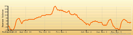
Temperature variation graph for the last seven days
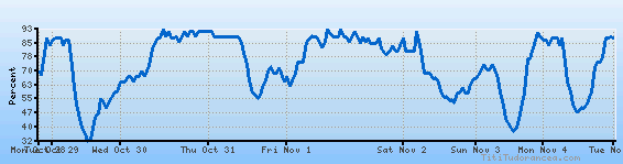
Humidity Variation Graph
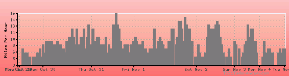
Wind speed
Weather Station: Houlton, Houlton International Airport (latitude 46-07-23N, longitude 067-47-31W)
Local Time:
Houlton is in the "America/New_York" timezone.
The "America/New_York" timezone uses a Standard Time (ST) / Daylight Saving Time (DST) alternation scheme, and it currently is in DST (since Sunday, 9 March 2025, 03:00 AM local time). During DST, the timezone abbreviation is EDT and the offset to Universal Time (UTC, GMT or Zulu) is -4:00 hours.
Houlton will exit DST (returning to standard time) on Sunday, 2 November 2025, at 02:00 AM local time, when clocks will be turned backward 1 hour to Sunday, 2 November 2025, 01:00 AM local standard time. During ST, the timezone abbreviation is EST and the offset to UTC will be -5:00 hours.
Weather and Temperature in Maine
Popular Weather Searches:
 If you own or manage a travel-related business such as a hotel, a bed-and-breakfast, a restaurant, a pub or a cafeteria, you can create a web page for your business for free on Titi Tudorancea Travel Info. » |