| Published in Weather / Michigan Weather Temperature |
Weather in Frankfort, Michigan
Current Conditions (Tuesday, March 11, 2025 at 20:15 America/Detroit time)
Temperature: 32°F (0°C) |
Forecast Overview
Wed Mar 12 
37°F 28°F 3°C -2°C Overcast skies.
detailsThu Mar 13 43°F 36°F 6°C 2°C Overcast skies.
detailsFri Mar 14 52°F 39°F 11°C 4°C Overcast skies.
detailsSat Mar 15 52°F 39°F 11°C 4°C Overcast skies.
detailsSun Mar 16 
41°F 27°F 5°C -3°C Chance of light snow in the afternoon.
detailsMon Mar 17 
39°F 28°F 4°C -2°C More clouds than sun.
detailsTue Mar 18 39°F 34°F 4°C 1°C Chance of light rain late at night.
detailsWed Mar 19 
46°F 32°F 8°C 0°C Chance of heavy rain most of the day. Chance of heavy snow late at night.
detailsThu Mar 20 39°F 27°F 4°C -3°C Chance of snow most of the day.
details
Detailed Forecast
| Wednesday, March 12 | sunrise: 08:05 sunset: 19:45 |
| Low around 29°F (-2°C), high around 38°F (3°C). Estimated precipitation: 0.01 in (0.25 mm). Overcast skies. Wind: 14 mph (22 km/h). |
| Time | Skies | Conditions | Temp | Wind | Humidity | Soil Moisture |
| 23:00 02:00 | Overcast. | 30°F (-1°C) | 11 mph (18 km/h) | 57% | N/A | |
| 02:00 05:00 | Overcast. | 32°F (0°C) | 11 mph (18 km/h) | 58% | N/A | |
| 05:00 08:00 | Overcast. Precipitation: 0.01 in (0.25 mm). | 32°F (0°C) | 14 mph (22 km/h) | 72% | N/A | |
| 08:00 11:00 | Overcast. | 34°F (1°C) | 13 mph (21 km/h) | 59% | N/A | |
| 11:00 14:00 | Overcast. | 38°F (3°C) | 1 mph (2 km/h) | 61% | N/A | |
| 14:00 17:00 | Overcast. | 37°F (3°C) | 9 mph (14 km/h) | 62% | N/A | |
| 17:00 20:00 | Overcast. | 37°F (3°C) | 6 mph (10 km/h) | 66% | N/A | |
| 20:00 23:00 | Overcast. | 37°F (3°C) | 4 mph (7 km/h) | 67% | N/A |
| Thursday, March 13 | sunrise: 08:03 sunset: 19:46 |
| Low around 36°F (2°C), high around 42°F (6°C). Overcast skies. Wind: 11 mph (18 km/h). |
| Time | Skies | Conditions | Temp | Wind | Humidity | Soil Moisture |
| 23:00 02:00 | Overcast. | 37°F (3°C) | 8 mph (13 km/h) | 69% | N/A | |
| 02:00 05:00 | Overcast. | 36°F (2°C) | 6 mph (9 km/h) | 71% | N/A | |
| 05:00 08:00 | Overcast. | 36°F (2°C) | 5 mph (8 km/h) | 70% | N/A | |
| 08:00 11:00 | Overcast. | 37°F (3°C) | 4 mph (7 km/h) | 71% | N/A | |
| 11:00 14:00 | Overcast. | 39°F (4°C) | 3 mph (4 km/h) | 70% | N/A | |
| 14:00 17:00 | Overcast. | 40°F (5°C) | 5 mph (9 km/h) | 69% | N/A | |
| 17:00 20:00 | Overcast. | 39°F (4°C) | 5 mph (8 km/h) | 73% | N/A | |
| 20:00 23:00 | Overcast. | 41°F (5°C) | 11 mph (18 km/h) | 77% | N/A |
| Friday, March 14 | sunrise: 08:01 sunset: 19:48 |
| Low around 39°F (4°C), high around 52°F (11°C). Estimated precipitation: 0 in (0.0625 mm). Overcast skies. Wind: 22 mph (35 km/h). |
| Time | Skies | Conditions | Temp | Wind | Humidity | Soil Moisture |
| 23:00 02:00 | Overcast. | 40°F (4°C) | 13 mph (21 km/h) | 82% | N/A | |
| 02:00 05:00 | Overcast. | 40°F (5°C) | 17 mph (27 km/h) | 82% | N/A | |
| 05:00 08:00 | Overcast. | 41°F (5°C) | 18 mph (28 km/h) | 87% | N/A | |
| 08:00 11:00 | Overcast. | 44°F (7°C) | 19 mph (31 km/h) | 90% | N/A | |
| 11:00 14:00 | Overcast. Precipitation: 0 in (0.0625 mm). | 48°F (9°C) | 17 mph (27 km/h) | 85% | N/A | |
| 14:00 17:00 | Mostly cloudy. | 51°F (10°C) | 16 mph (26 km/h) | 80% | N/A | |
| 17:00 20:00 | Overcast. | 51°F (11°C) | 18 mph (30 km/h) | 77% | N/A | |
| 20:00 23:00 | Overcast. | 51°F (10°C) | 22 mph (35 km/h) | 80% | N/A |
| Saturday, March 15 | sunrise: 07:59 sunset: 19:49 |
| Low around 39°F (4°C), high around 52°F (11°C). Estimated precipitation: 0.07 in (1.875 mm). Overcast skies. Wind: 40 mph (64 km/h). |
| Time | Skies | Conditions | Temp | Wind | Humidity | Soil Moisture |
| 23:00 02:00 | Overcast. | 51°F (11°C) | 26 mph (41 km/h) | 83% | N/A | |
| 02:00 05:00 | Overcast. Precipitation: 0.06 in (1.625 mm). | 44°F (7°C) | 17 mph (28 km/h) | 90% | N/A | |
| 05:00 08:00 | Partly cloudy. | 47°F (8°C) | 21 mph (33 km/h) | 91% | N/A | |
| 08:00 11:00 | Overcast. Precipitation: 0.01 in (0.1875 mm). | 49°F (9°C) | 32 mph (52 km/h) | 67% | N/A | |
| 11:00 14:00 | Overcast. | 45°F (7°C) | 40 mph (64 km/h) | 77% | N/A | |
| 14:00 17:00 | Overcast. Precipitation: 0 in (0.0625 mm). | 41°F (5°C) | 36 mph (58 km/h) | 88% | N/A | |
| 17:00 20:00 | Mostly cloudy. | 41°F (5°C) | 30 mph (49 km/h) | 83% | N/A | |
| 20:00 23:00 | Overcast. | 39°F (4°C) | 25 mph (41 km/h) | 84% | N/A |
| Sunday, March 16 | sunrise: 07:57 sunset: 19:50 |
| Low around 26°F (-3°C), high around 41°F (5°C). Chance of light snow during the afternoon (between 11 am and 5 pm). Estimated precipitation: 0.06 in (1.5 mm). Mostly cloudy skies. Wind: 32 mph (52 km/h). |
| Time | Skies | Conditions | Temp | Wind | Humidity | Soil Moisture |
| 23:00 02:00 | Clear. | 36°F (2°C) | 22 mph (36 km/h) | 81% | N/A | |
| 02:00 05:00 | Overcast. | 33°F (1°C) | 28 mph (45 km/h) | 72% | N/A | |
| 05:00 08:00 | Overcast. Precipitation: 0 in (0.0625 mm). | 31°F (-1°C) | 30 mph (48 km/h) | 70% | N/A | |
| 08:00 11:00 | Overcast. Precipitation: 0 in (0.0625 mm). | 29°F (-2°C) | 32 mph (52 km/h) | 70% | N/A | |
| 11:00 14:00 | Chance of light snow. Precipitation: 0 in (0.0625 mm). | 29°F (-2°C) | 31 mph (50 km/h) | 68% | N/A | |
| 14:00 17:00 | Chance of light snow. Precipitation: 0.02 in (0.5 mm). | 26°F (-3°C) | 32 mph (52 km/h) | 89% | N/A | |
| 17:00 20:00 | Overcast. Precipitation: 0.03 in (0.8125 mm). | 30°F (-1°C) | 28 mph (45 km/h) | 64% | N/A | |
| 20:00 23:00 | Overcast. | 31°F (-1°C) | 32 mph (51 km/h) | 53% | N/A |
| Monday, March 17 | sunrise: 07:55 sunset: 19:51 |
| Low around 29°F (-2°C), high around 39°F (4°C). More clouds than sun. Wind: 33 mph (53 km/h). |
| Time | Skies | Conditions | Temp | Wind | Humidity | Soil Moisture |
| 23:00 02:00 | Overcast. | 30°F (-1°C) | 28 mph (46 km/h) | 59% | N/A | |
| 02:00 05:00 | Mostly clear. | 29°F (-2°C) | 29 mph (46 km/h) | 62% | N/A | |
| 05:00 08:00 | Sunny. | 31°F (-1°C) | 33 mph (53 km/h) | 58% | N/A | |
| 08:00 11:00 | Sunny. | 32°F (-0°C) | 31 mph (49 km/h) | 55% | N/A | |
| 11:00 14:00 | Sunny. | 35°F (1°C) | 23 mph (37 km/h) | 53% | N/A | |
| 14:00 17:00 | Sunny. | 37°F (3°C) | 15 mph (24 km/h) | 59% | N/A | |
| 17:00 20:00 | Overcast. | 39°F (4°C) | 14 mph (23 km/h) | 64% | N/A | |
| 20:00 23:00 | Overcast. | 38°F (4°C) | 12 mph (20 km/h) | 68% | N/A |
| Tuesday, March 18 | sunrise: 07:54 sunset: 19:53 |
| Low around 35°F (1°C), high around 39°F (4°C). Chance of light rain late at night (after 8 pm). Estimated precipitation: 0 in (0.125 mm). Mostly cloudy skies. Wind: 29 mph (46 km/h). |
| Time | Skies | Conditions | Temp | Wind | Humidity | Soil Moisture |
| 23:00 02:00 | Overcast. | 36°F (2°C) | 9 mph (15 km/h) | 75% | N/A | |
| 02:00 05:00 | Overcast. | 36°F (2°C) | 9 mph (14 km/h) | 67% | N/A | |
| 05:00 08:00 | Sunny. | 35°F (2°C) | 11 mph (17 km/h) | 67% | N/A | |
| 08:00 11:00 | Considerable cloudiness. | 38°F (3°C) | 5 mph (9 km/h) | 63% | N/A | |
| 11:00 14:00 | Overcast. | 37°F (3°C) | 16 mph (26 km/h) | 78% | N/A | |
| 14:00 17:00 | Overcast. | 38°F (4°C) | 19 mph (31 km/h) | 75% | N/A | |
| 17:00 20:00 | Overcast. | 38°F (3°C) | 22 mph (35 km/h) | 76% | N/A | |
| 20:00 23:00 | Chance of light rain. Precipitation: 0 in (0.125 mm). | 35°F (2°C) | 29 mph (46 km/h) | 82% | N/A |
| Wednesday, March 19 | sunrise: 07:52 sunset: 19:54 |
| Low around 32°F (0°C), high around 46°F (8°C). Chance of heavy rain most of the night and day, except early afternoon (from 11 am to 2 pm). Chance of heavy snow late at night (after 8 pm). The precipitation may fall as scattered showers of varying intensity. Estimated precipitation: 0.96 in (24.4375 mm). Overcast skies. Wind: 31 mph (51 km/h). |
| Time | Skies | Conditions | Temp | Wind | Humidity | Soil Moisture |
| 23:00 02:00 | Chance of light rain. Precipitation: 0.01 in (0.375 mm). | 35°F (2°C) | 23 mph (38 km/h) | 85% | N/A | |
| 02:00 05:00 | Chance of light rain. Precipitation: 0.02 in (0.4375 mm). | 35°F (2°C) | 25 mph (41 km/h) | 91% | N/A | |
| 05:00 08:00 | Chance of rain. Precipitation: 0.13 in (3.25 mm). | 37°F (3°C) | 20 mph (32 km/h) | 94% | N/A | |
| 08:00 11:00 | Chance of rain. Precipitation: 0.11 in (2.8125 mm). | 41°F (5°C) | 16 mph (25 km/h) | 98% | N/A | |
| 11:00 14:00 | Overcast. Precipitation: 0.53 in (13.375 mm). | 46°F (8°C) | 26 mph (42 km/h) | 97% | N/A | |
| 14:00 17:00 | Chance of scattered rain showers. Precipitation: 0.06 in (1.625 mm). | 41°F (5°C) | 10 mph (16 km/h) | 99% | N/A | |
| 17:00 20:00 | Chance of scattered rain showers. Precipitation: 0.06 in (1.4375 mm). | 40°F (4°C) | 11 mph (17 km/h) | 100% | N/A | |
| 20:00 23:00 | Chance of snow. Precipitation: 0.04 in (1.125 mm). | 32°F (0°C) | 31 mph (51 km/h) | 93% | N/A |
| Thursday, March 20 | sunrise: 07:50 sunset: 19:55 |
| Low around 27°F (-3°C), high around 39°F (4°C). Chance of snow early in the morning (until 8 am) and during the afternoon and evening (from 11 am to 8 pm). Estimated precipitation: 0.15 in (3.6875 mm). Mostly cloudy skies. Wind: 40 mph (65 km/h). |
| Time | Skies | Conditions | Temp | Wind | Humidity | Soil Moisture |
| 23:00 02:00 | Chance of snow. Precipitation: 0.05 in (1.1875 mm). | 29°F (-2°C) | 40 mph (65 km/h) | 92% | N/A | |
| 02:00 05:00 | Chance of snow. Precipitation: 0.04 in (1.125 mm). | 27°F (-3°C) | 38 mph (60 km/h) | 88% | N/A | |
| 05:00 08:00 | Chance of light snow. Precipitation: 0.03 in (0.8125 mm). | 28°F (-2°C) | 37 mph (60 km/h) | 81% | N/A | |
| 08:00 11:00 | Overcast. Precipitation: 0.01 in (0.1875 mm). | 28°F (-2°C) | 35 mph (57 km/h) | 71% | N/A | |
| 11:00 14:00 | Chance of light snow. Precipitation: 0 in (0.125 mm). | 31°F (-1°C) | 27 mph (44 km/h) | 69% | N/A | |
| 14:00 17:00 | Chance of light snow. Precipitation: 0 in (0.0625 mm). | 33°F (1°C) | 26 mph (42 km/h) | 63% | N/A | |
| 17:00 20:00 | Chance of light snow. Precipitation: 0 in (0.125 mm). | 34°F (1°C) | 23 mph (37 km/h) | 64% | N/A | |
| 20:00 23:00 | Clear. Precipitation: 0 in (0.0625 mm). | 33°F (1°C) | 21 mph (34 km/h) | 61% | N/A |
Climate Chart
Places with a similar climate: Ludington, Mason County (MI), Harbor Springs (MI), Muskegon County (MI), Manistee County (MI), Port Hope (MI), Jamestown, Chautauqua County (NY), Fulton, Oswego County (NY), Portland (ME), South Haven (MI), Traverse City (MI), St. Clair County (MI), Toronto, Ontario (Canada), Beaver Island (MI), Augusta (ME), Brunswick (ME), Niagara Falls (NY), Benton Harbor, Michigan (MI), Mount Pocono (PA), Bar Harbor, Hancock County (ME), Monticello, Sullivan County (NY), Rockland, Knox County (ME), Caro, Tuscola Area (MI).
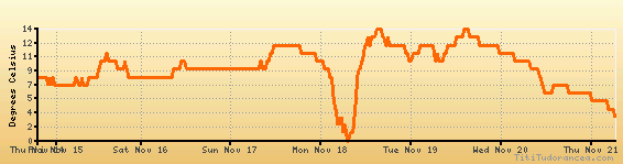
Temperature variation graph for the last seven days
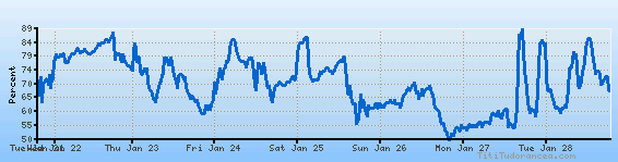
Humidity Variation Graph
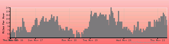
Wind speed
Weather Station: Frankfort, Frankfort Dow Memorial Field Airport (latitude 44-37-30N, longitude 086-12-02W)
Local Time:
Frankfort is in the "America/Detroit" timezone.
The "America/Detroit" timezone uses a Standard Time (ST) / Daylight Saving Time (DST) alternation scheme, and it currently is in DST (since Sunday, 9 March 2025, 03:00 AM local time). During DST, the timezone abbreviation is EDT and the offset to Universal Time (UTC, GMT or Zulu) is -4:00 hours.
Frankfort will exit DST (returning to standard time) on Sunday, 2 November 2025, at 02:00 AM local time, when clocks will be turned backward 1 hour to Sunday, 2 November 2025, 01:00 AM local standard time. During ST, the timezone abbreviation is EST and the offset to UTC will be -5:00 hours.
Weather and Temperature in Michigan
Popular Weather Searches:
 If you own or manage a travel-related business such as a hotel, a bed-and-breakfast, a restaurant, a pub or a cafeteria, you can create a web page for your business for free on Titi Tudorancea Travel Info. » |