| Published in Weather / Missouri Weather Temperature |
Weather in Fort Leonard Wood, Pulaski County, Missouri
Current Conditions (Thursday, March 13, 2025 at 11:55 America/Chicago time)
Temperature: 75°F (24°C) |
Forecast Overview
Fri Mar 14 
79°F 54°F 26°C 12°C Times of sun and clouds.
detailsSat Mar 15 
75°F 59°F 24°C 15°C Chance of rain in the afternoon.
detailsSun Mar 16 
63°F 43°F 17°C 6°C Mostly cloudy skies.
detailsMon Mar 17 55°F 36°F 13°C 2°C More sun than clouds.
detailsTue Mar 18 77°F 46°F 25°C 8°C More sun than clouds.
detailsWed Mar 19 73°F 57°F 23°C 14°C Mostly cloudy skies.
detailsThu Mar 20 
66°F 34°F 19°C 1°C Chance of light rain in the morning. Chance of light snow in the afternoon.
detailsFri Mar 21 
59°F 30°F 15°C -1°C A few passing clouds.
detailsSat Mar 22 
55°F 32°F 13°C 0°C Chance of rain in the afternoon.
details
Detailed Forecast
| Friday, March 14 | sunrise: 07:23 sunset: 19:13 |
| Low around 54°F (12°C), high around 79°F (26°C). Times of sun and clouds. Wind: 10 mph (16 km/h). |
| Time | Skies | Conditions | Temp | Wind | Humidity | Soil Moisture |
| 01:00 04:00 | Partly cloudy. | 56°F (13°C) | 3 mph (5 km/h) | 82% | 0.263% | |
| 04:00 07:00 | Clear. | 54°F (12°C) | 5 mph (8 km/h) | 92% | 0.264% | |
| 07:00 10:00 | Sunny. | 67°F (19°C) | 3 mph (5 km/h) | 62% | 0.265% | |
| 10:00 13:00 | Sunny. | 78°F (25°C) | 5 mph (8 km/h) | 35% | 0.262% | |
| 13:00 16:00 | Sunny. | 78°F (25°C) | 10 mph (16 km/h) | 34% | 0.257% | |
| 16:00 19:00 | Sunny. | 67°F (19°C) | 7 mph (11 km/h) | 62% | 0.255% | |
| 19:00 22:00 | Clear. | 62°F (17°C) | 9 mph (15 km/h) | 73% | 0.257% | |
| 22:00 01:00 | Overcast. | 60°F (15°C) | 9 mph (14 km/h) | 78% | 0.258% |
| Saturday, March 15 | sunrise: 07:21 sunset: 19:14 |
| Low around 58°F (15°C), high around 76°F (24°C). Chance of rain late in the afternoon (between 4 pm and 7 pm). The precipitation may fall as scattered showers of varying intensity. Estimated precipitation: 0.1 in (2.4375 mm). Mostly sunny, with a few passing clouds. Wind: 22 mph (35 km/h). |
| Time | Skies | Conditions | Temp | Wind | Humidity | Soil Moisture |
| 01:00 04:00 | Considerable cloudiness. | 60°F (15°C) | 10 mph (15 km/h) | 73% | 0.259% | |
| 04:00 07:00 | Clear. | 59°F (15°C) | 11 mph (18 km/h) | 72% | 0.26% | |
| 07:00 10:00 | Sunny. | 67°F (20°C) | 15 mph (25 km/h) | 50% | 0.259% | |
| 10:00 13:00 | Sunny. | 75°F (24°C) | 20 mph (33 km/h) | 41% | 0.254% | |
| 13:00 16:00 | Mostly cloudy. Precipitation: 0 in (0.0625 mm). | 74°F (23°C) | 22 mph (35 km/h) | 52% | 0.248% | |
| 16:00 19:00 | Chance of scattered rain showers. Precipitation: 0.09 in (2.3125 mm). | 65°F (18°C) | 20 mph (32 km/h) | 57% | 0.261% | |
| 19:00 22:00 | Clear. Precipitation: 0 in (0.0625 mm). | 61°F (16°C) | 21 mph (33 km/h) | 28% | 0.258% | |
| 22:00 01:00 | Clear. | 61°F (16°C) | 20 mph (32 km/h) | 26% | 0.254% |
| Sunday, March 16 | sunrise: 07:20 sunset: 19:15 |
| Low around 42°F (6°C), high around 63°F (17°C). Estimated precipitation: 0.01 in (0.3125 mm). Mostly cloudy skies. Wind: 16 mph (26 km/h). |
| Time | Skies | Conditions | Temp | Wind | Humidity | Soil Moisture |
| 01:00 04:00 | Overcast. | 59°F (15°C) | 16 mph (26 km/h) | 31% | 0.251% | |
| 04:00 07:00 | Overcast. | 54°F (12°C) | 10 mph (17 km/h) | 62% | 0.25% | |
| 07:00 10:00 | Overcast. | 57°F (14°C) | 9 mph (15 km/h) | 51% | 0.25% | |
| 10:00 13:00 | Overcast. Precipitation: 0.01 in (0.3125 mm). | 59°F (15°C) | 10 mph (16 km/h) | 56% | 0.25% | |
| 13:00 16:00 | Mostly cloudy. | 59°F (15°C) | 10 mph (16 km/h) | 54% | 0.248% | |
| 16:00 19:00 | Overcast. | 52°F (11°C) | 11 mph (18 km/h) | 60% | 0.248% | |
| 19:00 22:00 | Mostly cloudy. | 47°F (8°C) | 9 mph (14 km/h) | 60% | 0.248% | |
| 22:00 01:00 | Clear. | 42°F (6°C) | 9 mph (14 km/h) | 55% | 0.249% |
| Monday, March 17 | sunrise: 07:18 sunset: 19:16 |
| Low around 35°F (2°C), high around 56°F (13°C). More sun than clouds. Wind: 11 mph (17 km/h). |
| Time | Skies | Conditions | Temp | Wind | Humidity | Soil Moisture |
| 01:00 04:00 | Clear. | 39°F (4°C) | 11 mph (17 km/h) | 45% | 0.249% | |
| 04:00 07:00 | Clear. | 36°F (2°C) | 9 mph (14 km/h) | 53% | 0.25% | |
| 07:00 10:00 | Sunny. | 42°F (6°C) | 10 mph (17 km/h) | 37% | 0.25% | |
| 10:00 13:00 | Overcast. | 52°F (11°C) | 9 mph (15 km/h) | 25% | 0.246% | |
| 13:00 16:00 | Overcast. | 56°F (13°C) | 6 mph (10 km/h) | 27% | 0.243% | |
| 16:00 19:00 | Sunny. | 50°F (10°C) | 2 mph (3 km/h) | 51% | 0.243% | |
| 19:00 22:00 | Partly cloudy. | 45°F (7°C) | 6 mph (10 km/h) | 64% | 0.245% | |
| 22:00 01:00 | Clear. | 47°F (8°C) | 8 mph (12 km/h) | 58% | 0.245% |
| Tuesday, March 18 | sunrise: 07:17 sunset: 19:17 |
| Low around 47°F (8°C), high around 76°F (25°C). More sun than clouds. Wind: 14 mph (23 km/h). |
| Time | Skies | Conditions | Temp | Wind | Humidity | Soil Moisture |
| 01:00 04:00 | Clear. | 50°F (10°C) | 10 mph (17 km/h) | 51% | 0.246% | |
| 04:00 07:00 | Clear. | 49°F (9°C) | 11 mph (17 km/h) | 56% | 0.246% | |
| 07:00 10:00 | Sunny. | 59°F (15°C) | 12 mph (19 km/h) | 45% | 0.246% | |
| 10:00 13:00 | Sunny. | 71°F (22°C) | 13 mph (21 km/h) | 29% | 0.241% | |
| 13:00 16:00 | Sunny. | 76°F (24°C) | 12 mph (20 km/h) | 26% | 0.236% | |
| 16:00 19:00 | Overcast. | 65°F (18°C) | 10 mph (17 km/h) | 44% | 0.234% | |
| 19:00 22:00 | Clear. | 61°F (16°C) | 14 mph (23 km/h) | 51% | 0.234% | |
| 22:00 01:00 | Overcast. | 59°F (15°C) | 14 mph (23 km/h) | 58% | 0.234% |
| Wednesday, March 19 | sunrise: 07:15 sunset: 19:18 |
| Low around 58°F (14°C), high around 73°F (23°C). Mostly cloudy skies. Wind: 19 mph (31 km/h). |
| Time | Skies | Conditions | Temp | Wind | Humidity | Soil Moisture |
| 01:00 04:00 | Overcast. | 59°F (15°C) | 15 mph (24 km/h) | 56% | 0.233% | |
| 04:00 07:00 | Overcast. | 58°F (14°C) | 16 mph (25 km/h) | 61% | 0.233% | |
| 07:00 10:00 | Overcast. | 62°F (16°C) | 18 mph (28 km/h) | 47% | 0.232% | |
| 10:00 13:00 | Overcast. | 71°F (21°C) | 18 mph (29 km/h) | 35% | 0.229% | |
| 13:00 16:00 | Overcast. | 71°F (22°C) | 18 mph (29 km/h) | 42% | 0.224% | |
| 16:00 19:00 | Overcast. | 68°F (20°C) | 18 mph (29 km/h) | 53% | 0.223% | |
| 19:00 22:00 | Overcast. | 65°F (18°C) | 19 mph (31 km/h) | 62% | 0.222% | |
| 22:00 01:00 | Clear. | 64°F (18°C) | 17 mph (28 km/h) | 67% | 0.222% |
| Thursday, March 20 | sunrise: 07:14 sunset: 19:19 |
| Low around 34°F (1°C), high around 65°F (19°C). Chance of light rain in the morning (between 10 am and 1 pm). Chance of light snow early in the afternoon (between 1 pm and 4 pm). Estimated precipitation: 0.02 in (0.625 mm). More sun than clouds. Wind: 18 mph (29 km/h). |
| Time | Skies | Conditions | Temp | Wind | Humidity | Soil Moisture |
| 01:00 04:00 | A few passing clouds. Precipitation: 0 in (0.0625 mm). | 65°F (18°C) | 18 mph (29 km/h) | 67% | 0.222% | |
| 04:00 07:00 | Clear. Precipitation: 0 in (0.125 mm). | 51°F (10°C) | 14 mph (23 km/h) | 75% | 0.224% | |
| 07:00 10:00 | Overcast. | 46°F (8°C) | 15 mph (24 km/h) | 66% | 0.224% | |
| 10:00 13:00 | Chance of light rain. Precipitation: 0 in (0.125 mm). | 41°F (5°C) | 14 mph (23 km/h) | 74% | 0.225% | |
| 13:00 16:00 | Chance of light snow. Precipitation: 0.01 in (0.25 mm). | 42°F (5°C) | 15 mph (23 km/h) | 61% | 0.227% | |
| 16:00 19:00 | Sunny. Precipitation: 0 in (0.0625 mm). | 43°F (6°C) | 11 mph (17 km/h) | 42% | 0.227% | |
| 19:00 22:00 | Clear. | 37°F (3°C) | 5 mph (9 km/h) | 52% | 0.227% | |
| 22:00 01:00 | Clear. | 34°F (1°C) | 4 mph (7 km/h) | 61% | 0.228% |
| Friday, March 21 | sunrise: 07:12 sunset: 19:20 |
| Low around 31°F (-1°C), high around 60°F (15°C). A few passing clouds. Wind: 14 mph (22 km/h). |
| Time | Skies | Conditions | Temp | Wind | Humidity | Soil Moisture |
| 01:00 04:00 | Clear. | 32°F (0°C) | 4 mph (6 km/h) | 64% | 0.23% | |
| 04:00 07:00 | Clear. | 31°F (-1°C) | 4 mph (7 km/h) | 64% | 0.231% | |
| 07:00 10:00 | Sunny. | 45°F (7°C) | 6 mph (10 km/h) | 39% | 0.232% | |
| 10:00 13:00 | Sunny. | 56°F (13°C) | 7 mph (11 km/h) | 26% | 0.229% | |
| 13:00 16:00 | Sunny. | 59°F (15°C) | 10 mph (16 km/h) | 24% | 0.226% | |
| 16:00 19:00 | Sunny. | 52°F (11°C) | 9 mph (14 km/h) | 40% | 0.224% | |
| 19:00 22:00 | Partly cloudy. | 46°F (8°C) | 10 mph (16 km/h) | 54% | 0.225% | |
| 22:00 01:00 | Overcast. | 47°F (9°C) | 14 mph (22 km/h) | 47% | 0.225% |
| Saturday, March 22 | sunrise: 07:10 sunset: 19:21 |
| Low around 32°F (0°C), high around 55°F (13°C). Chance of rain during the afternoon (between 1 pm and 7 pm). Estimated precipitation: 0.13 in (3.25 mm). Mostly cloudy skies. Wind: 13 mph (21 km/h). |
| Time | Skies | Conditions | Temp | Wind | Humidity | Soil Moisture |
| 01:00 04:00 | Overcast. | 46°F (8°C) | 13 mph (20 km/h) | 49% | 0.224% | |
| 04:00 07:00 | Overcast. | 46°F (8°C) | 11 mph (17 km/h) | 54% | 0.224% | |
| 07:00 10:00 | Overcast. | 49°F (9°C) | 11 mph (18 km/h) | 51% | 0.224% | |
| 10:00 13:00 | Overcast. | 52°F (11°C) | 8 mph (14 km/h) | 48% | 0.224% | |
| 13:00 16:00 | Chance of light rain. Precipitation: 0 in (0.0625 mm). | 53°F (12°C) | 6 mph (10 km/h) | 53% | 0.224% | |
| 16:00 19:00 | Chance of rain. Precipitation: 0.12 in (3.125 mm). | 39°F (4°C) | 13 mph (21 km/h) | 96% | 0.247% | |
| 19:00 22:00 | Clear. Precipitation: 0 in (0.0625 mm). | 38°F (4°C) | 13 mph (21 km/h) | 80% | 0.248% | |
| 22:00 01:00 | Clear. | 32°F (0°C) | 10 mph (15 km/h) | 79% | 0.248% |
Climate Chart
» Fort Leonard Wood, Pulaski County Climate Chart
Places with a similar climate: Springfield (MO), Kaiser Lake Ozark (MO), Farmington (MO), Rolla / Vichy (MO), Jefferson City (MO), West Plains (MO), St. Louis (MO), Cahokia / St. Louis (IL), Monett City, Barry County (MO), Chanute (KS), Alton/St. Louis (IL), Sedalia (MO), Belleville, Scott (IL), Knob Noster City, Johnson County (MO), Fairfield (IL), Fayetteville/Springdale (AR), Sparta (IL), Mount Vernon (IL), Wichita (KS), Columbia (MO), Carbondale / Murphysboro (IL), Emporia (KS), Lynchburg (VA), Salem (IL), Dublin / New River Valley (VA).
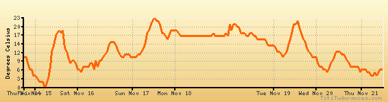
Temperature variation graph for the last seven days
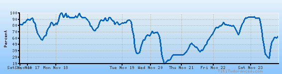
Humidity Variation Graph
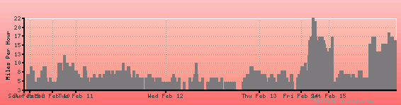
Wind speed
Weather Station: Fort Leonard Wood (latitude 37-44N, longitude 092-08W)
Local Time:
Fort Leonard Wood, Pulaski County is in the "America/Chicago" timezone.
The "America/Chicago" timezone uses a Standard Time (ST) / Daylight Saving Time (DST) alternation scheme, and it currently is in DST (since Sunday, 9 March 2025, 03:00 AM local time). During DST, the timezone abbreviation is CDT and the offset to Universal Time (UTC, GMT or Zulu) is -5:00 hours.
Fort Leonard Wood, Pulaski County will exit DST (returning to standard time) on Sunday, 2 November 2025, at 02:00 AM local time, when clocks will be turned backward 1 hour to Sunday, 2 November 2025, 01:00 AM local standard time. During ST, the timezone abbreviation is CST and the offset to UTC will be -6:00 hours.
Weather and Temperature in Missouri
Popular Weather Searches:
 If you own or manage a travel-related business such as a hotel, a bed-and-breakfast, a restaurant, a pub or a cafeteria, you can create a web page for your business for free on Titi Tudorancea Travel Info. » |