| Published in Weather / Kentucky Weather Temperature |
Weather in Fort Knox, Kentucky
Current Conditions (Monday, February 3, 2025 at 01:55 America/New_York time)
Temperature: 48°F (9°C) |
Forecast Overview
Mon Feb 3 
64°F 46°F 18°C 8°C Chance of light rain after 7 pm.
detailsTue Feb 4 
57°F 37°F 14°C 3°C Mostly cloudy skies.
detailsWed Feb 5 
54°F 36°F 12°C 2°C Chance of rain at various times.
detailsThu Feb 6 
61°F 41°F 16°C 5°C Chance of rain in the morning.
detailsFri Feb 7 
45°F 37°F 7°C 3°C Chance of rain late at night.
detailsSat Feb 8 64°F 37°F 18°C 3°C Chance of rain in the morning.
detailsSun Feb 9 39°F 28°F 4°C -2°C Partly cloudy skies.
detailsMon Feb 10 
39°F 28°F 4°C -2°C Chance of light snow late at night.
detailsTue Feb 11 
34°F 30°F 1°C -1°C Chance of rain after 4 pm. Chance of snow until 4 pm.
details
Detailed Forecast
| Monday, February 3 | sunrise: 07:47 sunset: 18:08 |
| Low around 47°F (8°C), high around 64°F (18°C). Chance of light rain in the evening (between 7 pm and 10 pm). Estimated precipitation: 0.01 in (0.25 mm). Mostly cloudy skies. Wind: 14 mph (22 km/h). |
| Time | Skies | Conditions | Temp | Wind | Humidity | Soil Moisture |
| 01:00 04:00 | Overcast. | 48°F (9°C) | 8 mph (12 km/h) | 90% | 0.337% | |
| 04:00 07:00 | Overcast. | 48°F (9°C) | 8 mph (13 km/h) | 88% | 0.337% | |
| 07:00 10:00 | Sunny. | 54°F (12°C) | 11 mph (17 km/h) | 79% | 0.335% | |
| 10:00 13:00 | Sunny. | 63°F (17°C) | 14 mph (22 km/h) | 70% | 0.332% | |
| 13:00 16:00 | Sunny. | 64°F (18°C) | 13 mph (21 km/h) | 71% | 0.33% | |
| 16:00 19:00 | Overcast. | 58°F (15°C) | 9 mph (15 km/h) | 84% | 0.331% | |
| 19:00 22:00 | Chance of light rain. Precipitation: 0 in (0.0625 mm). | 59°F (15°C) | 10 mph (16 km/h) | 88% | 0.332% | |
| 22:00 01:00 | Overcast. Precipitation: 0.01 in (0.1875 mm). | 57°F (14°C) | 10 mph (16 km/h) | 94% | 0.332% |
| Tuesday, February 4 | sunrise: 07:46 sunset: 18:09 |
| Low around 38°F (3°C), high around 58°F (14°C). Mostly cloudy skies. Wind: 10 mph (16 km/h). |
| Time | Skies | Conditions | Temp | Wind | Humidity | Soil Moisture |
| 01:00 04:00 | Overcast. | 51°F (11°C) | 9 mph (14 km/h) | 91% | 0.332% | |
| 04:00 07:00 | Clear. | 42°F (6°C) | 8 mph (13 km/h) | 88% | 0.331% | |
| 07:00 10:00 | Overcast. | 41°F (5°C) | 10 mph (16 km/h) | 78% | 0.33% | |
| 10:00 13:00 | Overcast. | 46°F (8°C) | 8 mph (13 km/h) | 63% | 0.328% | |
| 13:00 16:00 | Times of sun and clouds. | 48°F (9°C) | 7 mph (11 km/h) | 56% | 0.326% | |
| 16:00 19:00 | Overcast. | 42°F (5°C) | 5 mph (8 km/h) | 75% | 0.327% | |
| 19:00 22:00 | Overcast. | 40°F (4°C) | 7 mph (11 km/h) | 69% | 0.327% | |
| 22:00 01:00 | Overcast. | 38°F (3°C) | 7 mph (11 km/h) | 73% | 0.327% |
| Wednesday, February 5 | sunrise: 07:45 sunset: 18:10 |
| Low around 35°F (2°C), high around 54°F (12°C). Chance of rain between 7 am and 10 am and after 4 pm. The precipitation may fall as scattered showers of varying intensity. Estimated precipitation: 0.78 in (19.9375 mm). Overcast skies. Wind: 10 mph (16 km/h). |
| Time | Skies | Conditions | Temp | Wind | Humidity | Soil Moisture |
| 01:00 04:00 | Overcast. | 37°F (3°C) | 7 mph (11 km/h) | 77% | 0.327% | |
| 04:00 07:00 | Overcast. | 37°F (3°C) | 8 mph (13 km/h) | 75% | 0.327% | |
| 07:00 10:00 | Chance of rain. Precipitation: 0.13 in (3.375 mm). | 36°F (2°C) | 7 mph (12 km/h) | 91% | 0.349% | |
| 10:00 13:00 | Overcast. Precipitation: 0.27 in (6.9375 mm). | 36°F (2°C) | 8 mph (13 km/h) | 95% | 0.361% | |
| 13:00 16:00 | Overcast. Precipitation: 0.12 in (2.9375 mm). | 37°F (3°C) | 8 mph (12 km/h) | 96% | 0.365% | |
| 16:00 19:00 | Chance of rain. Precipitation: 0.08 in (2.0625 mm). | 38°F (4°C) | 7 mph (11 km/h) | 98% | 0.362% | |
| 19:00 22:00 | Chance of light rain. Precipitation: 0.03 in (0.875 mm). | 41°F (5°C) | 4 mph (7 km/h) | 99% | 0.358% | |
| 22:00 01:00 | Chance of scattered rain showers. Precipitation: 0.15 in (3.75 mm). | 54°F (12°C) | 10 mph (16 km/h) | 99% | 0.373% |
| Thursday, February 6 | sunrise: 07:44 sunset: 18:11 |
| Low around 41°F (5°C), high around 61°F (16°C). Chance of rain in the morning (before 7 am and from 10 am to 1 pm). The precipitation may fall as scattered showers of varying intensity. Estimated precipitation: 0.27 in (6.9375 mm). Partly cloudy skies. Wind: 13 mph (21 km/h). |
| Time | Skies | Conditions | Temp | Wind | Humidity | Soil Moisture |
| 01:00 04:00 | Chance of scattered rain showers. Precipitation: 0.16 in (4.1875 mm). | 60°F (15°C) | 13 mph (21 km/h) | 96% | 0.372% | |
| 04:00 07:00 | Chance of light rain. Precipitation: 0.02 in (0.625 mm). | 61°F (16°C) | 12 mph (19 km/h) | 93% | 0.364% | |
| 07:00 10:00 | Overcast. Precipitation: 0.07 in (1.6875 mm). | 59°F (15°C) | 10 mph (16 km/h) | 96% | 0.365% | |
| 10:00 13:00 | Chance of light rain. Precipitation: 0.01 in (0.375 mm). | 60°F (15°C) | 9 mph (14 km/h) | 96% | 0.36% | |
| 13:00 16:00 | Mostly cloudy. Precipitation: 0 in (0.0625 mm). | 55°F (13°C) | 7 mph (12 km/h) | 90% | 0.355% | |
| 16:00 19:00 | Clear. | 51°F (11°C) | 6 mph (10 km/h) | 86% | 0.352% | |
| 19:00 22:00 | Clear. | 45°F (7°C) | 6 mph (10 km/h) | 92% | 0.351% | |
| 22:00 01:00 | Clear. | 41°F (5°C) | 5 mph (8 km/h) | 91% | 0.349% |
| Friday, February 7 | sunrise: 07:43 sunset: 18:12 |
| Low around 38°F (3°C), high around 44°F (7°C). Chance of rain late at night (after 10 pm). The precipitation may fall as scattered showers of varying intensity. Estimated precipitation: 0.12 in (3 mm). Overcast skies. Wind: 10 mph (16 km/h). |
| Time | Skies | Conditions | Temp | Wind | Humidity | Soil Moisture |
| 01:00 04:00 | Overcast. | 40°F (4°C) | 5 mph (8 km/h) | 77% | 0.348% | |
| 04:00 07:00 | Overcast. | 38°F (3°C) | 4 mph (7 km/h) | 71% | 0.346% | |
| 07:00 10:00 | Overcast. | 38°F (3°C) | 6 mph (9 km/h) | 70% | 0.345% | |
| 10:00 13:00 | Mostly cloudy. | 42°F (5°C) | 6 mph (10 km/h) | 53% | 0.342% | |
| 13:00 16:00 | Overcast. | 42°F (6°C) | 5 mph (9 km/h) | 59% | 0.341% | |
| 16:00 19:00 | Overcast. | 42°F (5°C) | 8 mph (12 km/h) | 72% | 0.34% | |
| 19:00 22:00 | Overcast. Precipitation: 0.02 in (0.625 mm). | 41°F (5°C) | 10 mph (16 km/h) | 83% | 0.341% | |
| 22:00 01:00 | Chance of scattered rain showers. Precipitation: 0.09 in (2.375 mm). | 44°F (7°C) | 6 mph (10 km/h) | 96% | 0.352% |
| Saturday, February 8 | sunrise: 07:42 sunset: 18:13 |
| Low around 37°F (3°C), high around 65°F (18°C). Chance of rain all morning (between 4 am and 1 pm). The precipitation may fall as scattered showers of varying intensity. Estimated precipitation: 0.26 in (6.5625 mm). Mostly cloudy skies. Wind: 17 mph (27 km/h). |
| Time | Skies | Conditions | Temp | Wind | Humidity | Soil Moisture |
| 01:00 04:00 | Overcast. Precipitation: 0.07 in (1.8125 mm). | 51°F (11°C) | 4 mph (6 km/h) | 99% | 0.355% | |
| 04:00 07:00 | Chance of light rain. Precipitation: 0.01 in (0.25 mm). | 61°F (16°C) | 14 mph (22 km/h) | 95% | 0.351% | |
| 07:00 10:00 | Chance of light rain. Precipitation: 0.02 in (0.4375 mm). | 63°F (17°C) | 16 mph (25 km/h) | 92% | 0.35% | |
| 10:00 13:00 | Chance of light rain. Precipitation: 0.03 in (0.75 mm). | 63°F (17°C) | 15 mph (25 km/h) | 92% | 0.35% | |
| 13:00 16:00 | Overcast. Precipitation: 0.02 in (0.625 mm). | 65°F (18°C) | 17 mph (27 km/h) | 90% | 0.35% | |
| 16:00 19:00 | Considerable cloudiness. Precipitation: 0.09 in (2.375 mm). | 49°F (10°C) | 11 mph (18 km/h) | 91% | 0.357% | |
| 19:00 22:00 | Mostly cloudy. Precipitation: 0.01 in (0.3125 mm). | 43°F (6°C) | 10 mph (16 km/h) | 87% | 0.351% | |
| 22:00 01:00 | Clear. | 37°F (3°C) | 9 mph (14 km/h) | 88% | 0.348% |
| Sunday, February 9 | sunrise: 07:41 sunset: 18:14 |
| Low around 28°F (-2°C), high around 39°F (4°C). Partly cloudy skies. Wind: 10 mph (15 km/h). |
| Time | Skies | Conditions | Temp | Wind | Humidity | Soil Moisture |
| 01:00 04:00 | Overcast. | 36°F (2°C) | 7 mph (12 km/h) | 79% | 0.346% | |
| 04:00 07:00 | Overcast. | 33°F (1°C) | 7 mph (12 km/h) | 86% | 0.345% | |
| 07:00 10:00 | Overcast. | 34°F (1°C) | 9 mph (15 km/h) | 71% | 0.343% | |
| 10:00 13:00 | Overcast. | 38°F (3°C) | 9 mph (14 km/h) | 56% | 0.34% | |
| 13:00 16:00 | Mostly cloudy. | 39°F (4°C) | 10 mph (15 km/h) | 51% | 0.338% | |
| 16:00 19:00 | Clear. | 33°F (1°C) | 5 mph (8 km/h) | 70% | 0.338% | |
| 19:00 22:00 | Clear. | 30°F (-1°C) | 5 mph (8 km/h) | 73% | 0.337% | |
| 22:00 01:00 | A few passing clouds. | 28°F (-2°C) | 5 mph (8 km/h) | 69% | 0.336% |
| Monday, February 10 | sunrise: 07:40 sunset: 18:16 |
| Low around 28°F (-2°C), high around 39°F (4°C). Chance of light snow late at night (after 10 pm). Estimated precipitation: 0.02 in (0.5625 mm). Overcast skies. Wind: 8 mph (12 km/h). |
| Time | Skies | Conditions | Temp | Wind | Humidity | Soil Moisture |
| 01:00 04:00 | Overcast. | 28°F (-2°C) | 5 mph (8 km/h) | 66% | 0.337% | |
| 04:00 07:00 | Mostly cloudy. | 28°F (-2°C) | 5 mph (7 km/h) | 60% | 0.337% | |
| 07:00 10:00 | Overcast. | 32°F (0°C) | 7 mph (11 km/h) | 46% | 0.337% | |
| 10:00 13:00 | Overcast. | 38°F (3°C) | 7 mph (11 km/h) | 35% | 0.336% | |
| 13:00 16:00 | Overcast. | 39°F (4°C) | 7 mph (12 km/h) | 35% | 0.333% | |
| 16:00 19:00 | Overcast. | 34°F (1°C) | 5 mph (8 km/h) | 54% | 0.332% | |
| 19:00 22:00 | Overcast. | 34°F (1°C) | 8 mph (12 km/h) | 55% | 0.332% | |
| 22:00 01:00 | Chance of light snow. Precipitation: 0.02 in (0.5625 mm). | 33°F (1°C) | 6 mph (10 km/h) | 59% | 0.331% |
| Tuesday, February 11 | sunrise: 07:39 sunset: 18:17 |
| Low around 29°F (-1°C), high around 34°F (1°C). Chance of rain after 4 pm. Chance of snow until late afternoon (4 pm). Estimated precipitation: 1.14 in (29 mm). Overcast skies. Wind: 10 mph (16 km/h). |
| Time | Skies | Conditions | Temp | Wind | Humidity | Soil Moisture |
| 01:00 04:00 | Chance of snow. Precipitation: 0.09 in (2.1875 mm). | 32°F (-0°C) | 8 mph (12 km/h) | 73% | 0.33% | |
| 04:00 07:00 | Chance of snow. Precipitation: 0.06 in (1.5625 mm). | 29°F (-1°C) | 8 mph (13 km/h) | 93% | 0.331% | |
| 07:00 10:00 | Chance of snow. Precipitation: 0.04 in (1.125 mm). | 31°F (-1°C) | 10 mph (16 km/h) | 95% | 0.331% | |
| 10:00 13:00 | Chance of snow. Precipitation: 0.05 in (1.3125 mm). | 31°F (-1°C) | 10 mph (15 km/h) | 96% | 0.331% | |
| 13:00 16:00 | Chance of snow. Precipitation: 0.15 in (3.6875 mm). | 32°F (0°C) | 9 mph (15 km/h) | 98% | 0.332% | |
| 16:00 19:00 | Chance of rain. Precipitation: 0.16 in (4.125 mm). | 32°F (0°C) | 9 mph (14 km/h) | 99% | 0.338% | |
| 19:00 22:00 | Chance of rain. Precipitation: 0.31 in (7.875 mm). | 33°F (1°C) | 7 mph (11 km/h) | 99% | 0.389% | |
| 22:00 01:00 | Chance of rain. Precipitation: 0.28 in (7.125 mm). | 34°F (1°C) | 9 mph (14 km/h) | 99% | 0.44% |
Climate Chart
Places with a similar climate: Evansville (IN), Louisville (KY), Marion, Williamson County (IL), Owensboro, Daviess County (KY), Carbondale / Murphysboro (IL), Harrisburg (IL), Sparta (IL), Louisville (KY), Henderson City (KY), Cape Girardeau (MO), Huntingburg (IN), London (KY), Frankfort (KY), Lexington (KY), Huntington (WV), Clarksville (TN), Carmi (IL), Salem (IL), Washington DC (VA), Robinson (IL), Fairfield (IL), Jackson (KY), Fort Belvoir (VA), St. Louis (MO), West Plains (MO).
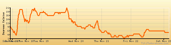
Temperature variation graph for the last seven days
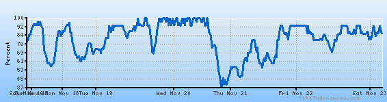
Humidity Variation Graph
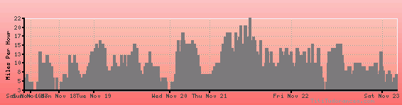
Wind speed
Weather Station: Fort Knox (latitude 37-54N, longitude 085-58W)
Local Time:
Fort Knox is in the "America/New_York" timezone.
The "America/New_York" timezone uses a Standard Time (ST) / Daylight Saving Time (DST) alternation scheme, and it currently is in ST (since Sunday, 3 November 2024, 01:00 AM local time). During ST, the timezone abbreviation is EST and the offset to Universal Time (UTC, GMT or Zulu) is -5:00 hours.
Fort Knox will exit standard time (entering DST) on Sunday, 9 March 2025, at 02:00 AM local time, when clocks will be turned forward 1 hour to Sunday, 9 March 2025, 03:00 AM local daylight time. During DST, the timezone abbreviation is EDT and the offset to UTC will be -4:00 hours.
Weather and Temperature in Kentucky
Popular Weather Searches:
 If you own or manage a travel-related business such as a hotel, a bed-and-breakfast, a restaurant, a pub or a cafeteria, you can create a web page for your business for free on Titi Tudorancea Travel Info. » |