| Published in Weather / North Dakota Weather Temperature |
Weather in Fargo, North Dakota
Current Conditions (Thursday, March 13, 2025 at 11:53 America/Chicago time)
Temperature: 54°F (12°C) |
Forecast Overview
Fri Mar 14 
59°F 36°F 15°C 2°C Overcast skies.
detailsSat Mar 15 68°F 37°F 20°C 3°C Overcast skies.
detailsSun Mar 16 
37°F 14°F 3°C -10°C Chance of snow in the morning. Chance of freezing rain before sunrise.
detailsMon Mar 17 
25°F 9°F -4°C -13°C Times of sun and clouds.
detailsTue Mar 18 32°F 9°F -0°C -13°C Overcast skies.
detailsWed Mar 19 
30°F 18°F -1°C -8°C Chance of snow at various times.
detailsThu Mar 20 
36°F 5°F 2°C -15°C Chance of light snow in the afternoon.
detailsFri Mar 21 21°F 3°F -6°C -16°C More sun than clouds.
detailsSat Mar 22 
21°F -6°F -6°C -21°C A few passing clouds.
details
Detailed Forecast
| Friday, March 14 | sunrise: 07:44 sunset: 19:29 |
| Low around 35°F (2°C), high around 59°F (15°C). Overcast skies. Wind: 16 mph (26 km/h). |
| Time | Skies | Conditions | Temp | Wind | Humidity | Soil Moisture |
| 01:00 04:00 | Overcast. | 36°F (2°C) | 7 mph (11 km/h) | 62% | 0.32% | |
| 04:00 07:00 | Considerable cloudiness. | 36°F (2°C) | 9 mph (14 km/h) | 63% | 0.319% | |
| 07:00 10:00 | Considerable cloudiness. | 42°F (6°C) | 10 mph (16 km/h) | 52% | 0.318% | |
| 10:00 13:00 | Overcast. | 55°F (13°C) | 16 mph (26 km/h) | 43% | 0.314% | |
| 13:00 16:00 | Overcast. | 59°F (15°C) | 15 mph (24 km/h) | 47% | 0.308% | |
| 16:00 19:00 | Overcast. | 56°F (13°C) | 10 mph (16 km/h) | 58% | 0.306% | |
| 19:00 22:00 | Overcast. | 51°F (11°C) | 10 mph (16 km/h) | 67% | 0.305% | |
| 22:00 01:00 | Overcast. | 53°F (12°C) | 16 mph (25 km/h) | 57% | 0.305% |
| Saturday, March 15 | sunrise: 07:42 sunset: 19:31 |
| Low around 37°F (3°C), high around 67°F (20°C). Overcast skies. Wind: 24 mph (38 km/h). |
| Time | Skies | Conditions | Temp | Wind | Humidity | Soil Moisture |
| 01:00 04:00 | Overcast. | 51°F (11°C) | 13 mph (21 km/h) | 69% | 0.304% | |
| 04:00 07:00 | Overcast. | 51°F (11°C) | 13 mph (21 km/h) | 81% | 0.303% | |
| 07:00 10:00 | Overcast. | 53°F (12°C) | 11 mph (17 km/h) | 81% | 0.303% | |
| 10:00 13:00 | Overcast. | 62°F (17°C) | 9 mph (15 km/h) | 59% | 0.301% | |
| 13:00 16:00 | Overcast. | 67°F (20°C) | 11 mph (18 km/h) | 46% | 0.297% | |
| 16:00 19:00 | Overcast. | 61°F (16°C) | 2 mph (2 km/h) | 58% | 0.295% | |
| 19:00 22:00 | Overcast. | 44°F (7°C) | 20 mph (31 km/h) | 85% | 0.294% | |
| 22:00 01:00 | Overcast. | 37°F (3°C) | 24 mph (38 km/h) | 84% | 0.293% |
| Sunday, March 16 | sunrise: 07:40 sunset: 19:32 |
| Low around 15°F (-10°C), high around 37°F (3°C). Chance of snow all morning (between 4 am and 1 pm). Chance of freezing rain between 1 am and 4 am. Estimated precipitation: 0.78 in (19.9375 mm). Mostly cloudy skies. Wind: 30 mph (49 km/h). |
| Time | Skies | Conditions | Temp | Wind | Humidity | Soil Moisture |
| 01:00 04:00 | Possibly freezing rain leading to formation of glaze ice. Precipitation: 0.04 in (0.9375 mm). | 31°F (-1°C) | 26 mph (41 km/h) | 87% | 0.295% | |
| 04:00 07:00 | Chance of snow. Precipitation: 0.19 in (4.9375 mm). | 26°F (-3°C) | 30 mph (49 km/h) | 93% | 0.296% | |
| 07:00 10:00 | Chance of snow. Precipitation: 0.23 in (5.8125 mm). | 22°F (-5°C) | 23 mph (38 km/h) | 94% | 0.296% | |
| 10:00 13:00 | Chance of snow. Precipitation: 0.28 in (7.125 mm). | 22°F (-6°C) | 21 mph (35 km/h) | 94% | 0.296% | |
| 13:00 16:00 | Overcast. Precipitation: 0.04 in (1.125 mm). | 24°F (-4°C) | 20 mph (33 km/h) | 76% | 0.295% | |
| 16:00 19:00 | Overcast. | 22°F (-5°C) | 17 mph (28 km/h) | 72% | 0.295% | |
| 19:00 22:00 | Clear. | 18°F (-8°C) | 15 mph (24 km/h) | 75% | 0.295% | |
| 22:00 01:00 | Clear. | 15°F (-10°C) | 12 mph (20 km/h) | 79% | 0.295% |
| Monday, March 17 | sunrise: 07:38 sunset: 19:34 |
| Low around 8°F (-13°C), high around 25°F (-4°C). Times of sun and clouds. Wind: 11 mph (18 km/h). |
| Time | Skies | Conditions | Temp | Wind | Humidity | Soil Moisture |
| 01:00 04:00 | Clear. | 12°F (-11°C) | 10 mph (16 km/h) | 82% | 0.295% | |
| 04:00 07:00 | Clear. | 10°F (-12°C) | 8 mph (13 km/h) | 86% | 0.295% | |
| 07:00 10:00 | Sunny. | 16°F (-9°C) | 10 mph (15 km/h) | 83% | 0.295% | |
| 10:00 13:00 | Overcast. | 21°F (-6°C) | 11 mph (18 km/h) | 72% | 0.295% | |
| 13:00 16:00 | Sunny. | 25°F (-4°C) | 7 mph (12 km/h) | 69% | 0.295% | |
| 16:00 19:00 | Sunny. | 19°F (-7°C) | 4 mph (7 km/h) | 83% | 0.295% | |
| 19:00 22:00 | Overcast. | 12°F (-11°C) | 7 mph (12 km/h) | 87% | 0.295% | |
| 22:00 01:00 | Clear. | 11°F (-12°C) | 6 mph (9 km/h) | 91% | 0.295% |
| Tuesday, March 18 | sunrise: 07:36 sunset: 19:35 |
| Low around 8°F (-13°C), high around 32°F (-0°C). Overcast skies. Wind: 11 mph (18 km/h). |
| Time | Skies | Conditions | Temp | Wind | Humidity | Soil Moisture |
| 01:00 04:00 | Clear. | 9°F (-13°C) | 5 mph (8 km/h) | 93% | 0.295% | |
| 04:00 07:00 | Overcast. | 9°F (-13°C) | 5 mph (8 km/h) | 95% | 0.295% | |
| 07:00 10:00 | Sunny. | 20°F (-7°C) | 4 mph (7 km/h) | 89% | 0.295% | |
| 10:00 13:00 | Overcast. | 29°F (-2°C) | 4 mph (7 km/h) | 86% | 0.297% | |
| 13:00 16:00 | Overcast. | 31°F (-0°C) | 6 mph (9 km/h) | 95% | 0.309% | |
| 16:00 19:00 | Mostly cloudy. | 29°F (-1°C) | 4 mph (7 km/h) | 97% | 0.313% | |
| 19:00 22:00 | Overcast. | 27°F (-3°C) | 8 mph (12 km/h) | 96% | 0.313% | |
| 22:00 01:00 | Overcast. | 30°F (-1°C) | 11 mph (18 km/h) | 88% | 0.313% |
| Wednesday, March 19 | sunrise: 07:34 sunset: 19:36 |
| Low around 18°F (-8°C), high around 31°F (-1°C). Chance of snow all night and all morning (until 1 pm) and again late in the afternoon (between 4 pm and 7 pm). Estimated precipitation: 0.23 in (5.875 mm). Overcast skies. Wind: 22 mph (36 km/h). |
| Time | Skies | Conditions | Temp | Wind | Humidity | Soil Moisture |
| 01:00 04:00 | Chance of light snow. Precipitation: 0 in (0.125 mm). | 29°F (-2°C) | 18 mph (28 km/h) | 91% | 0.313% | |
| 04:00 07:00 | Chance of light snow. Precipitation: 0.03 in (0.8125 mm). | 30°F (-1°C) | 16 mph (26 km/h) | 95% | 0.313% | |
| 07:00 10:00 | Chance of light snow. Precipitation: 0.04 in (0.9375 mm). | 27°F (-3°C) | 18 mph (29 km/h) | 94% | 0.313% | |
| 10:00 13:00 | Chance of snow. Precipitation: 0.09 in (2.375 mm). | 25°F (-4°C) | 22 mph (36 km/h) | 91% | 0.313% | |
| 13:00 16:00 | Overcast. Precipitation: 0.05 in (1.1875 mm). | 26°F (-3°C) | 20 mph (32 km/h) | 85% | 0.313% | |
| 16:00 19:00 | Chance of light snow. Precipitation: 0.01 in (0.375 mm). | 25°F (-4°C) | 18 mph (28 km/h) | 88% | 0.313% | |
| 19:00 22:00 | Overcast. Precipitation: 0 in (0.0625 mm). | 20°F (-6°C) | 17 mph (28 km/h) | 85% | 0.313% | |
| 22:00 01:00 | Overcast. | 18°F (-8°C) | 14 mph (23 km/h) | 89% | 0.313% |
| Thursday, March 20 | sunrise: 07:32 sunset: 19:38 |
| Low around 4°F (-15°C), high around 35°F (2°C). Chance of light snow late in the afternoon (between 4 pm and 7 pm). Estimated precipitation: 0.01 in (0.25 mm). More clouds than sun. Wind: 12 mph (20 km/h). |
| Time | Skies | Conditions | Temp | Wind | Humidity | Soil Moisture |
| 01:00 04:00 | Overcast. | 14°F (-10°C) | 10 mph (16 km/h) | 91% | 0.313% | |
| 04:00 07:00 | Clear. | 5°F (-15°C) | 4 mph (6 km/h) | 97% | 0.313% | |
| 07:00 10:00 | A few passing clouds. | 16°F (-9°C) | 3 mph (5 km/h) | 92% | 0.313% | |
| 10:00 13:00 | A few passing clouds. | 27°F (-3°C) | 8 mph (13 km/h) | 82% | 0.313% | |
| 13:00 16:00 | Mostly sunny, with a few passing clouds. | 33°F (0°C) | 11 mph (17 km/h) | 85% | 0.316% | |
| 16:00 19:00 | Chance of light snow. Precipitation: 0 in (0.125 mm). | 35°F (1°C) | 12 mph (20 km/h) | 87% | 0.322% | |
| 19:00 22:00 | Clear. Precipitation: 0 in (0.125 mm). | 25°F (-4°C) | 6 mph (9 km/h) | 88% | 0.322% | |
| 22:00 01:00 | Overcast. | 20°F (-7°C) | 7 mph (11 km/h) | 91% | 0.322% |
| Friday, March 21 | sunrise: 07:30 sunset: 19:39 |
| Low around 3°F (-16°C), high around 22°F (-6°C). More sun than clouds. Wind: 7 mph (11 km/h). |
| Time | Skies | Conditions | Temp | Wind | Humidity | Soil Moisture |
| 01:00 04:00 | Considerable cloudiness. | 12°F (-11°C) | 4 mph (7 km/h) | 97% | 0.322% | |
| 04:00 07:00 | Overcast. | 7°F (-14°C) | 4 mph (7 km/h) | 99% | 0.322% | |
| 07:00 10:00 | Considerable cloudiness. | 14°F (-10°C) | 6 mph (10 km/h) | 95% | 0.322% | |
| 10:00 13:00 | Sunny. | 19°F (-7°C) | 6 mph (9 km/h) | 80% | 0.322% | |
| 13:00 16:00 | Overcast. | 22°F (-6°C) | 7 mph (11 km/h) | 77% | 0.322% | |
| 16:00 19:00 | Sunny. | 17°F (-9°C) | 3 mph (5 km/h) | 89% | 0.322% | |
| 19:00 22:00 | Clear. | 6°F (-14°C) | 5 mph (8 km/h) | 95% | 0.322% | |
| 22:00 01:00 | Clear. | 3°F (-16°C) | 6 mph (9 km/h) | 94% | 0.322% |
| Saturday, March 22 | sunrise: 07:28 sunset: 19:41 |
| Low around -6°F (-21°C), high around 21°F (-6°C). A few passing clouds. Wind: 15 mph (24 km/h). |
| Time | Skies | Conditions | Temp | Wind | Humidity | Soil Moisture |
| 01:00 04:00 | Clear. | 0°F (-18°C) | 6 mph (9 km/h) | 95% | 0.322% | |
| 04:00 07:00 | Clear. | -5°F (-21°C) | 3 mph (5 km/h) | 99% | 0.322% | |
| 07:00 10:00 | Sunny. | 7°F (-14°C) | 3 mph (4 km/h) | 87% | 0.322% | |
| 10:00 13:00 | Sunny. | 16°F (-9°C) | 3 mph (4 km/h) | 76% | 0.322% | |
| 13:00 16:00 | Sunny. | 21°F (-6°C) | 7 mph (12 km/h) | 74% | 0.322% | |
| 16:00 19:00 | Sunny. | 17°F (-8°C) | 9 mph (14 km/h) | 86% | 0.322% | |
| 19:00 22:00 | A few passing clouds. | 14°F (-10°C) | 13 mph (21 km/h) | 80% | 0.322% | |
| 22:00 01:00 | Overcast. | 18°F (-8°C) | 15 mph (24 km/h) | 79% | 0.322% |
Climate Chart
Places with a similar climate: Moorhead (MN), Wahpeton (ND), Fergus Falls (MN), Fosston (MN), Alexandria, Chandler Field (MN), Roseau (MN), Sisseton (SD), Brainerd Crow Wing County (MN), Glenwood (MN), Detroit Lakes (MN), Paynesville (MN), Appleton (MN), Elbow Lake City, Grant County (MN), St Cloud (MN), Jamestown (ND), Morris (MN), Watertown (SD), Minot (ND), Staples (MN), Ortonville (MN), Benson (MN), Aberdeen (SD), Princeton (MN), Hutchinson (MN), Grand Forks (ND).
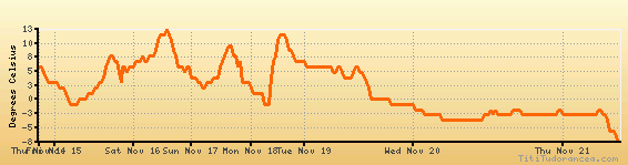
Temperature variation graph for the last seven days
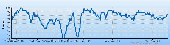
Humidity Variation Graph
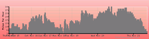
Wind speed
Weather Station: Fargo, Hector International Airport (latitude 46-55-31N, longitude 096-48-40W)
Local Time:
Fargo is in the "America/Chicago" timezone.
The "America/Chicago" timezone uses a Standard Time (ST) / Daylight Saving Time (DST) alternation scheme, and it currently is in DST (since Sunday, 9 March 2025, 03:00 AM local time). During DST, the timezone abbreviation is CDT and the offset to Universal Time (UTC, GMT or Zulu) is -5:00 hours.
Fargo will exit DST (returning to standard time) on Sunday, 2 November 2025, at 02:00 AM local time, when clocks will be turned backward 1 hour to Sunday, 2 November 2025, 01:00 AM local standard time. During ST, the timezone abbreviation is CST and the offset to UTC will be -6:00 hours.
Weather and Temperature in North Dakota
Popular Weather Searches:
 If you own or manage a travel-related business such as a hotel, a bed-and-breakfast, a restaurant, a pub or a cafeteria, you can create a web page for your business for free on Titi Tudorancea Travel Info. » |