| Published in Weather / Turkey Weather Temperature |
Weather in Elazig, Turkey
Current Conditions (Wednesday, February 19, 2025 at 07:50 Europe/Istanbul time)
Temperature: 45°F (7°C) |
Forecast Overview
Wed Feb 19 
39°F 30°F 4°C -1°C Chance of snow most of the day.
detailsThu Feb 20 32°F 14°F 0°C -10°C Chance of snow until 6 pm.
detailsFri Feb 21 
19°F 5°F -7°C -15°C A few passing clouds.
detailsSat Feb 22 
18°F 1°F -8°C -17°C More sun than clouds.
detailsSun Feb 23 
19°F 5°F -7°C -15°C Chance of snow most of the day.
detailsMon Feb 24 
23°F 10°F -5°C -12°C Chance of snow before sunrise.
detailsTue Feb 25 21°F 5°F -6°C -15°C Mostly sunny.
detailsWed Feb 26 
23°F 3°F -5°C -16°C Sunny skies.
detailsThu Feb 27 
28°F 9°F -2°C -13°C Considerable cloudiness.
details
Detailed Forecast
| Wednesday, February 19 | sunrise: 07:10 sunset: 18:03 |
| Low around 31°F (-1°C), high around 39°F (4°C). Chance of snow almost all day (except from 12 pm to 3 pm). Estimated precipitation: 0.4 in (10.25 mm). Overcast skies. Wind: 6 mph (10 km/h). |
| Time | Skies | Conditions | Temp | Wind | Humidity | Soil Moisture |
| 00:00 03:00 | Chance of light snow. Precipitation: 0.01 in (0.1875 mm). | 34°F (1°C) | 5 mph (8 km/h) | 98% | 0.352% | |
| 03:00 06:00 | Mostly cloudy. Precipitation: 0 in (0.0625 mm). | 34°F (1°C) | 5 mph (8 km/h) | 96% | 0.345% | |
| 06:00 09:00 | Chance of light snow. Precipitation: 0 in (0.0625 mm). | 35°F (2°C) | 5 mph (8 km/h) | 91% | 0.34% | |
| 09:00 12:00 | Chance of light snow. Precipitation: 0.01 in (0.25 mm). | 37°F (3°C) | 6 mph (10 km/h) | 91% | 0.333% | |
| 12:00 15:00 | Overcast. Precipitation: 0 in (0.0625 mm). | 38°F (3°C) | 5 mph (9 km/h) | 91% | 0.314% | |
| 15:00 18:00 | Chance of light snow. Precipitation: 0.01 in (0.25 mm). | 36°F (2°C) | 2 mph (3 km/h) | 97% | 0.308% | |
| 18:00 21:00 | Chance of snow. Precipitation: 0.13 in (3.1875 mm). | 33°F (0°C) | 4 mph (6 km/h) | 99% | 0.313% | |
| 21:00 00:00 | Chance of snow. Precipitation: 0.24 in (6.1875 mm). | 31°F (-0°C) | 1 mph (1 km/h) | 99% | 0.308% |
| Thursday, February 20 | sunrise: 07:09 sunset: 18:04 |
| Low around 14°F (-10°C), high around 33°F (0°C). Chance of snow until 6 pm. Estimated precipitation: 0.88 in (22.3125 mm). Overcast skies. Wind: 7 mph (11 km/h). |
| Time | Skies | Conditions | Temp | Wind | Humidity | Soil Moisture |
| 00:00 03:00 | Chance of snow. Precipitation: 0.17 in (4.4375 mm). | 31°F (-0°C) | 3 mph (4 km/h) | 100% | 0.304% | |
| 03:00 06:00 | Chance of snow. Precipitation: 0.13 in (3.1875 mm). | 29°F (-2°C) | 5 mph (7 km/h) | 98% | 0.301% | |
| 06:00 09:00 | Chance of snow. Precipitation: 0.26 in (6.5 mm). | 27°F (-3°C) | 5 mph (8 km/h) | 97% | 0.299% | |
| 09:00 12:00 | Chance of snow. Precipitation: 0.12 in (2.9375 mm). | 26°F (-3°C) | 5 mph (9 km/h) | 96% | 0.298% | |
| 12:00 15:00 | Chance of snow. Precipitation: 0.15 in (3.8125 mm). | 25°F (-4°C) | 6 mph (9 km/h) | 95% | 0.296% | |
| 15:00 18:00 | Chance of snow. Precipitation: 0.06 in (1.4375 mm). | 22°F (-5°C) | 4 mph (7 km/h) | 94% | 0.295% | |
| 18:00 21:00 | Overcast. | 19°F (-7°C) | 7 mph (11 km/h) | 92% | 0.294% | |
| 21:00 00:00 | Overcast. | 14°F (-10°C) | 6 mph (10 km/h) | 94% | 0.293% |
| Friday, February 21 | sunrise: 07:08 sunset: 18:05 |
| Low around 4°F (-15°C), high around 20°F (-7°C). A few passing clouds. Wind: 11 mph (17 km/h). |
| Time | Skies | Conditions | Temp | Wind | Humidity | Soil Moisture |
| 00:00 03:00 | Times of clear skies and clouds. | 11°F (-12°C) | 6 mph (10 km/h) | 93% | 0.292% | |
| 03:00 06:00 | Partly cloudy. | 5°F (-15°C) | 6 mph (10 km/h) | 93% | 0.291% | |
| 06:00 09:00 | Sunny. | 12°F (-11°C) | 6 mph (9 km/h) | 87% | 0.29% | |
| 09:00 12:00 | More sun than clouds. | 18°F (-8°C) | 9 mph (15 km/h) | 67% | 0.29% | |
| 12:00 15:00 | Partly cloudy. | 20°F (-7°C) | 11 mph (17 km/h) | 64% | 0.29% | |
| 15:00 18:00 | Sunny. | 10°F (-12°C) | 3 mph (6 km/h) | 78% | 0.29% | |
| 18:00 21:00 | Clear. | 8°F (-14°C) | 7 mph (11 km/h) | 71% | 0.29% | |
| 21:00 00:00 | Mostly clear, with a few passing clouds. | 6°F (-15°C) | 5 mph (7 km/h) | 70% | 0.29% |
| Saturday, February 22 | sunrise: 07:06 sunset: 18:06 |
| Low around 1°F (-17°C), high around 17°F (-8°C). More sun than clouds. Wind: 4 mph (6 km/h). |
| Time | Skies | Conditions | Temp | Wind | Humidity | Soil Moisture |
| 00:00 03:00 | Clear. | 3°F (-16°C) | 3 mph (4 km/h) | 72% | 0.29% | |
| 03:00 06:00 | Clear. | 1°F (-17°C) | 2 mph (4 km/h) | 86% | 0.29% | |
| 06:00 09:00 | Mostly sunny, with a few passing clouds. | 9°F (-13°C) | 2 mph (3 km/h) | 88% | 0.291% | |
| 09:00 12:00 | Mostly sunny, with a few passing clouds. | 13°F (-11°C) | 4 mph (6 km/h) | 79% | 0.292% | |
| 12:00 15:00 | Overcast. | 16°F (-9°C) | 3 mph (5 km/h) | 73% | 0.292% | |
| 15:00 18:00 | Overcast. | 10°F (-12°C) | 2 mph (3 km/h) | 88% | 0.293% | |
| 18:00 21:00 | Clear. | 6°F (-14°C) | 3 mph (5 km/h) | 89% | 0.293% | |
| 21:00 00:00 | Overcast. | 7°F (-14°C) | 3 mph (4 km/h) | 83% | 0.294% |
| Sunday, February 23 | sunrise: 07:05 sunset: 18:07 |
| Low around 6°F (-15°C), high around 19°F (-7°C). Chance of snow most of the day (after 9 am). Estimated precipitation: 0.14 in (3.5 mm). Overcast skies. Wind: 6 mph (10 km/h). |
| Time | Skies | Conditions | Temp | Wind | Humidity | Soil Moisture |
| 00:00 03:00 | Overcast. | 8°F (-14°C) | 2 mph (3 km/h) | 87% | 0.295% | |
| 03:00 06:00 | Overcast. | 10°F (-12°C) | 2 mph (4 km/h) | 92% | 0.296% | |
| 06:00 09:00 | Overcast. | 15°F (-10°C) | 4 mph (6 km/h) | 82% | 0.297% | |
| 09:00 12:00 | Chance of light snow. Precipitation: 0.03 in (0.6875 mm). | 16°F (-9°C) | 5 mph (8 km/h) | 89% | 0.297% | |
| 12:00 15:00 | Chance of light snow. Precipitation: 0.02 in (0.625 mm). | 19°F (-7°C) | 6 mph (10 km/h) | 91% | 0.298% | |
| 15:00 18:00 | Chance of light snow. Precipitation: 0.02 in (0.625 mm). | 17°F (-9°C) | 4 mph (7 km/h) | 95% | 0.299% | |
| 18:00 21:00 | Chance of light snow. Precipitation: 0.02 in (0.5 mm). | 16°F (-9°C) | 4 mph (6 km/h) | 96% | 0.299% | |
| 21:00 00:00 | Chance of snow. Precipitation: 0.04 in (1.0625 mm). | 16°F (-9°C) | 4 mph (6 km/h) | 96% | 0.3% |
| Monday, February 24 | sunrise: 07:04 sunset: 18:09 |
| Low around 10°F (-12°C), high around 24°F (-5°C). Chance of snow before sunrise (from midnight to 6 am). Estimated precipitation: 0.09 in (2.25 mm). Partly cloudy skies. Wind: 10 mph (17 km/h). |
| Time | Skies | Conditions | Temp | Wind | Humidity | Soil Moisture |
| 00:00 03:00 | Chance of snow. Precipitation: 0.04 in (1 mm). | 16°F (-9°C) | 3 mph (5 km/h) | 96% | 0.3% | |
| 03:00 06:00 | Chance of snow. Precipitation: 0.05 in (1.1875 mm). | 16°F (-9°C) | 4 mph (6 km/h) | 95% | 0.301% | |
| 06:00 09:00 | Overcast. Precipitation: 0 in (0.0625 mm). | 15°F (-10°C) | 5 mph (9 km/h) | 79% | 0.301% | |
| 09:00 12:00 | Overcast. | 20°F (-6°C) | 6 mph (9 km/h) | 62% | 0.302% | |
| 12:00 15:00 | Overcast. | 23°F (-5°C) | 7 mph (12 km/h) | 56% | 0.302% | |
| 15:00 18:00 | Sunny. | 14°F (-10°C) | 6 mph (9 km/h) | 71% | 0.303% | |
| 18:00 21:00 | Clear. | 13°F (-11°C) | 10 mph (16 km/h) | 80% | 0.304% | |
| 21:00 00:00 | Clear. | 10°F (-12°C) | 10 mph (17 km/h) | 80% | 0.304% |
| Tuesday, February 25 | sunrise: 07:02 sunset: 18:10 |
| Low around 5°F (-15°C), high around 22°F (-6°C). Mostly sunny. Wind: 9 mph (14 km/h). |
| Time | Skies | Conditions | Temp | Wind | Humidity | Soil Moisture |
| 00:00 03:00 | Clear. | 8°F (-13°C) | 9 mph (14 km/h) | 80% | 0.305% | |
| 03:00 06:00 | Clear. | 6°F (-15°C) | 8 mph (13 km/h) | 84% | 0.305% | |
| 06:00 09:00 | Sunny. | 14°F (-10°C) | 5 mph (8 km/h) | 81% | 0.306% | |
| 09:00 12:00 | Sunny. | 20°F (-7°C) | 7 mph (11 km/h) | 68% | 0.306% | |
| 12:00 15:00 | Partly cloudy. | 22°F (-6°C) | 7 mph (12 km/h) | 62% | 0.307% | |
| 15:00 18:00 | Sunny. | 11°F (-12°C) | 6 mph (9 km/h) | 80% | 0.307% | |
| 18:00 21:00 | Clear. | 8°F (-13°C) | 7 mph (11 km/h) | 75% | 0.308% | |
| 21:00 00:00 | Clear. | 6°F (-14°C) | 5 mph (9 km/h) | 83% | 0.308% |
| Wednesday, February 26 | sunrise: 07:01 sunset: 18:11 |
| Low around 3°F (-16°C), high around 23°F (-5°C). Sunny skies. Wind: 4 mph (7 km/h). |
| Time | Skies | Conditions | Temp | Wind | Humidity | Soil Moisture |
| 00:00 03:00 | Clear. | 5°F (-15°C) | 4 mph (7 km/h) | 87% | 0.309% | |
| 03:00 06:00 | Clear. | 3°F (-16°C) | 3 mph (6 km/h) | 89% | 0.309% | |
| 06:00 09:00 | Sunny. | 12°F (-11°C) | 2 mph (4 km/h) | 83% | 0.31% | |
| 09:00 12:00 | Sunny. | 18°F (-8°C) | 4 mph (7 km/h) | 75% | 0.311% | |
| 12:00 15:00 | Sunny. | 22°F (-6°C) | 3 mph (5 km/h) | 77% | 0.312% | |
| 15:00 18:00 | Sunny. | 15°F (-9°C) | 1 mph (2 km/h) | 89% | 0.313% | |
| 18:00 21:00 | Clear. | 13°F (-11°C) | 3 mph (4 km/h) | 86% | 0.313% | |
| 21:00 00:00 | Clear. | 12°F (-11°C) | 2 mph (3 km/h) | 84% | 0.314% |
| Thursday, February 27 | sunrise: 07:00 sunset: 18:12 |
| Low around 9°F (-13°C), high around 28°F (-2°C). Considerable cloudiness. Wind: 3 mph (5 km/h). |
| Time | Skies | Conditions | Temp | Wind | Humidity | Soil Moisture |
| 00:00 03:00 | Mostly clear. | 10°F (-12°C) | 2 mph (3 km/h) | 88% | 0.314% | |
| 03:00 06:00 | Mostly clear, with a few passing clouds. | 9°F (-13°C) | 2 mph (3 km/h) | 91% | 0.315% | |
| 06:00 09:00 | Mostly sunny, with a few passing clouds. | 17°F (-9°C) | 2 mph (2 km/h) | 89% | 0.316% | |
| 09:00 12:00 | Sunny. | 23°F (-5°C) | 3 mph (4 km/h) | 79% | 0.322% | |
| 12:00 15:00 | Overcast. | 27°F (-3°C) | 2 mph (4 km/h) | 88% | 0.341% | |
| 15:00 18:00 | Overcast. | 20°F (-7°C) | 2 mph (3 km/h) | 94% | 0.343% | |
| 18:00 21:00 | Overcast. | 19°F (-7°C) | 3 mph (5 km/h) | 91% | 0.343% | |
| 21:00 00:00 | Overcast. | 18°F (-8°C) | 2 mph (4 km/h) | 89% | 0.343% |
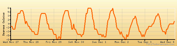
Temperature variation graph for the last seven days
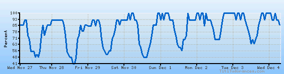
Humidity Variation Graph
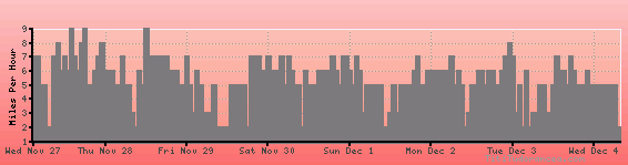
Wind speed
Weather Station: Elazig (latitude 38-36N, longitude 039-17E)
Local Time:
Elazig is in the "Europe/Istanbul" timezone.
The "Europe/Istanbul" timezone uses a Standard Time (ST) / Daylight Saving Time (DST) alternation scheme, and it currently is in ST (since Wednesday, 7 September 2016, 00:00 AM local time). During ST, the offset to Universal Time (UTC, GMT or Zulu) is +3:00 hours.
Elazig will exit standard time (entering DST) on Tuesday, 19 January 2038, at 06:14 AM local time, when clocks will be turned forward 0 hour to Tuesday, 19 January 2038, 06:14 AM local daylight time. During DST, the offset to UTC will be +3:00 hours.
Weather and Temperature in Turkey
Popular Weather Searches:
 If you own or manage a travel-related business such as a hotel, a bed-and-breakfast, a restaurant, a pub or a cafeteria, you can create a web page for your business for free on Titi Tudorancea Travel Info. » |