| Published in Weather / Washington Weather Temperature |
Weather in Eastsound, Washington
Current Conditions (Saturday, February 1, 2025 at 17:55 America/Los_Angeles time)
Temperature: 36°F (2°C) |
Forecast Overview
Sun Feb 2 
39°F 23°F 4°C -5°C Chance of snow all day.
detailsMon Feb 3 
27°F 19°F -3°C -7°C Chance of snow before sunrise.
detailsTue Feb 4 
28°F 18°F -2°C -8°C Overcast skies.
detailsWed Feb 5 
30°F 19°F -1°C -7°C Times of sun and clouds.
detailsThu Feb 6 
37°F 25°F 3°C -4°C Partly cloudy skies.
detailsFri Feb 7 37°F 28°F 3°C -2°C Chance of snow all day.
detailsSat Feb 8 39°F 36°F 4°C 2°C Chance of light snow before sunrise.
detailsSun Feb 9 37°F 34°F 3°C 1°C Chance of snow in the morning.
detailsMon Feb 10 37°F 32°F 3°C -0°C Considerable cloudiness.
details
Detailed Forecast
| Saturday, February 1 | sunrise: 07:42 sunset: 17:08 |
| Chance of light snow in the morning (between 10 am and 1 pm). Estimated precipitation: 0 in (0.125 mm). Overcast skies. Wind: 17 mph (27 km/h). |
| Time | Skies | Conditions | Temp | Wind | Humidity | Soil Moisture |
| 16:00 19:00 | Overcast. | 39°F (4°C) | 17 mph (27 km/h) | 63% | N/A | |
| 19:00 22:00 | Overcast. | 39°F (4°C) | 15 mph (25 km/h) | 60% | N/A | |
| 22:00 01:00 | Considerable cloudiness. Precipitation: 0 in (0.125 mm). | 38°F (3°C) | 11 mph (17 km/h) | 62% | N/A |
| Sunday, February 2 | sunrise: 07:41 sunset: 17:09 |
| Low around 23°F (-5°C), high around 39°F (4°C). Chance of snow all day. Estimated precipitation: 0.31 in (7.875 mm). Overcast skies. Wind: 25 mph (40 km/h). |
| Time | Skies | Conditions | Temp | Wind | Humidity | Soil Moisture |
| 01:00 04:00 | Chance of light snow. Precipitation: 0.02 in (0.625 mm). | 36°F (2°C) | 11 mph (17 km/h) | 74% | N/A | |
| 04:00 07:00 | Overcast. Precipitation: 0.02 in (0.5 mm). | 36°F (2°C) | 20 mph (33 km/h) | 83% | N/A | |
| 07:00 10:00 | Chance of light snow. Precipitation: 0.03 in (0.875 mm). | 36°F (2°C) | 19 mph (30 km/h) | 81% | N/A | |
| 10:00 13:00 | Chance of snow. Precipitation: 0.04 in (1.0625 mm). | 33°F (1°C) | 17 mph (28 km/h) | 87% | N/A | |
| 13:00 16:00 | Chance of light snow. Precipitation: 0.03 in (0.75 mm). | 31°F (-0°C) | 19 mph (30 km/h) | 87% | N/A | |
| 16:00 19:00 | Chance of light snow. Precipitation: 0.02 in (0.4375 mm). | 30°F (-1°C) | 21 mph (34 km/h) | 78% | N/A | |
| 19:00 22:00 | Chance of snow. Precipitation: 0.04 in (1 mm). | 25°F (-4°C) | 25 mph (40 km/h) | 96% | N/A | |
| 22:00 01:00 | Chance of snow. Precipitation: 0.1 in (2.625 mm). | 23°F (-5°C) | 24 mph (39 km/h) | 96% | N/A |
| Monday, February 3 | sunrise: 07:40 sunset: 17:11 |
| Low around 19°F (-7°C), high around 26°F (-3°C). Chance of snow before sunrise (from 1 am to 7 am). Estimated precipitation: 0.07 in (1.6875 mm). Mostly cloudy skies. Wind: 26 mph (42 km/h). |
| Time | Skies | Conditions | Temp | Wind | Humidity | Soil Moisture |
| 01:00 04:00 | Chance of snow. Precipitation: 0.04 in (1.125 mm). | 21°F (-6°C) | 24 mph (39 km/h) | 97% | N/A | |
| 04:00 07:00 | Chance of light snow. Precipitation: 0.01 in (0.3125 mm). | 19°F (-7°C) | 25 mph (41 km/h) | 94% | N/A | |
| 07:00 10:00 | Overcast. Precipitation: 0.01 in (0.25 mm). | 20°F (-7°C) | 24 mph (38 km/h) | 79% | N/A | |
| 10:00 13:00 | Overcast. | 23°F (-5°C) | 22 mph (35 km/h) | 68% | N/A | |
| 13:00 16:00 | Sunny. | 26°F (-3°C) | 23 mph (36 km/h) | 63% | N/A | |
| 16:00 19:00 | A few passing clouds. | 24°F (-4°C) | 26 mph (42 km/h) | 64% | N/A | |
| 19:00 22:00 | Overcast. | 21°F (-6°C) | 24 mph (38 km/h) | 67% | N/A | |
| 22:00 01:00 | Overcast. | 20°F (-7°C) | 22 mph (35 km/h) | 69% | N/A |
| Tuesday, February 4 | sunrise: 07:38 sunset: 17:13 |
| Low around 18°F (-8°C), high around 28°F (-2°C). Overcast skies. Wind: 23 mph (38 km/h). |
| Time | Skies | Conditions | Temp | Wind | Humidity | Soil Moisture |
| 01:00 04:00 | Overcast. | 19°F (-7°C) | 20 mph (33 km/h) | 71% | N/A | |
| 04:00 07:00 | Overcast. | 19°F (-7°C) | 20 mph (32 km/h) | 70% | N/A | |
| 07:00 10:00 | Overcast. | 20°F (-7°C) | 20 mph (32 km/h) | 68% | N/A | |
| 10:00 13:00 | Overcast. | 24°F (-4°C) | 20 mph (31 km/h) | 63% | N/A | |
| 13:00 16:00 | Overcast. | 28°F (-2°C) | 20 mph (32 km/h) | 62% | N/A | |
| 16:00 19:00 | Overcast. | 27°F (-3°C) | 23 mph (38 km/h) | 62% | N/A | |
| 19:00 22:00 | Mostly cloudy. | 24°F (-4°C) | 21 mph (34 km/h) | 62% | N/A | |
| 22:00 01:00 | Overcast. | 22°F (-6°C) | 21 mph (34 km/h) | 67% | N/A |
| Wednesday, February 5 | sunrise: 07:37 sunset: 17:14 |
| Low around 19°F (-7°C), high around 30°F (-1°C). Times of sun and clouds. Wind: 18 mph (29 km/h). |
| Time | Skies | Conditions | Temp | Wind | Humidity | Soil Moisture |
| 01:00 04:00 | Times of clear skies and clouds. | 21°F (-6°C) | 17 mph (28 km/h) | 67% | N/A | |
| 04:00 07:00 | Overcast. | 19°F (-7°C) | 18 mph (29 km/h) | 71% | N/A | |
| 07:00 10:00 | Overcast. | 20°F (-7°C) | 17 mph (28 km/h) | 69% | N/A | |
| 10:00 13:00 | Sunny. | 25°F (-4°C) | 14 mph (22 km/h) | 61% | N/A | |
| 13:00 16:00 | Times of sun and clouds. | 29°F (-2°C) | 11 mph (18 km/h) | 57% | N/A | |
| 16:00 19:00 | Clear. | 30°F (-1°C) | 13 mph (21 km/h) | 61% | N/A | |
| 19:00 22:00 | Clear. | 28°F (-2°C) | 15 mph (24 km/h) | 63% | N/A | |
| 22:00 01:00 | Clear. | 26°F (-4°C) | 16 mph (26 km/h) | 63% | N/A |
| Thursday, February 6 | sunrise: 07:35 sunset: 17:16 |
| Low around 24°F (-4°C), high around 37°F (3°C). Partly cloudy skies. Wind: 15 mph (25 km/h). |
| Time | Skies | Conditions | Temp | Wind | Humidity | Soil Moisture |
| 01:00 04:00 | Clear. | 25°F (-4°C) | 15 mph (25 km/h) | 64% | N/A | |
| 04:00 07:00 | Clear. | 25°F (-4°C) | 14 mph (22 km/h) | 63% | N/A | |
| 07:00 10:00 | Sunny. | 27°F (-3°C) | 12 mph (20 km/h) | 58% | N/A | |
| 10:00 13:00 | Overcast. | 31°F (-1°C) | 10 mph (17 km/h) | 54% | N/A | |
| 13:00 16:00 | Overcast. | 34°F (1°C) | 12 mph (20 km/h) | 61% | N/A | |
| 16:00 19:00 | Overcast. | 36°F (2°C) | 14 mph (23 km/h) | 65% | N/A | |
| 19:00 22:00 | Overcast. | 35°F (1°C) | 12 mph (20 km/h) | 64% | N/A | |
| 22:00 01:00 | Overcast. | 31°F (-0°C) | 13 mph (21 km/h) | 62% | N/A |
| Friday, February 7 | sunrise: 07:34 sunset: 17:18 |
| Low around 29°F (-2°C), high around 38°F (3°C). Chance of snow all day (from 4 am to 1 am). Estimated precipitation: 0.2 in (5 mm). Overcast skies. Wind: 10 mph (16 km/h). |
| Time | Skies | Conditions | Temp | Wind | Humidity | Soil Moisture |
| 01:00 04:00 | Overcast. Precipitation: 0 in (0.0625 mm). | 30°F (-1°C) | 9 mph (14 km/h) | 70% | N/A | |
| 04:00 07:00 | Chance of light snow. Precipitation: 0 in (0.125 mm). | 30°F (-1°C) | 6 mph (9 km/h) | 88% | N/A | |
| 07:00 10:00 | Chance of snow. Precipitation: 0.07 in (1.75 mm). | 33°F (0°C) | 7 mph (11 km/h) | 97% | N/A | |
| 10:00 13:00 | Chance of snow. Precipitation: 0.06 in (1.5625 mm). | 34°F (1°C) | 7 mph (12 km/h) | 98% | N/A | |
| 13:00 16:00 | Chance of light snow. Precipitation: 0.03 in (0.6875 mm). | 36°F (2°C) | 7 mph (11 km/h) | 90% | N/A | |
| 16:00 19:00 | Chance of light snow. Precipitation: 0.01 in (0.25 mm). | 37°F (3°C) | 7 mph (11 km/h) | 75% | N/A | |
| 19:00 22:00 | Chance of light snow. Precipitation: 0.01 in (0.25 mm). | 37°F (3°C) | 8 mph (14 km/h) | 80% | N/A | |
| 22:00 01:00 | Chance of light snow. Precipitation: 0.01 in (0.3125 mm). | 37°F (3°C) | 10 mph (16 km/h) | 81% | N/A |
| Saturday, February 8 | sunrise: 07:32 sunset: 17:19 |
| Low around 35°F (2°C), high around 39°F (4°C). Chance of light snow before sunrise (from 1 am to 7 am). Estimated precipitation: 0.05 in (1.1875 mm). Overcast skies. Wind: 10 mph (16 km/h). |
| Time | Skies | Conditions | Temp | Wind | Humidity | Soil Moisture |
| 01:00 04:00 | Chance of light snow. Precipitation: 0.02 in (0.4375 mm). | 36°F (2°C) | 10 mph (16 km/h) | 85% | N/A | |
| 04:00 07:00 | Chance of light snow. Precipitation: 0.01 in (0.25 mm). | 36°F (2°C) | 7 mph (12 km/h) | 85% | N/A | |
| 07:00 10:00 | Overcast. Precipitation: 0.01 in (0.25 mm). | 37°F (3°C) | 9 mph (14 km/h) | 83% | N/A | |
| 10:00 13:00 | Overcast. Precipitation: 0 in (0.125 mm). | 38°F (3°C) | 7 mph (11 km/h) | 78% | N/A | |
| 13:00 16:00 | Overcast. Precipitation: 0 in (0.0625 mm). | 38°F (4°C) | 2 mph (3 km/h) | 73% | N/A | |
| 16:00 19:00 | Overcast. | 38°F (3°C) | 4 mph (6 km/h) | 78% | N/A | |
| 19:00 22:00 | Overcast. | 37°F (3°C) | 7 mph (11 km/h) | 85% | N/A | |
| 22:00 01:00 | Overcast. Precipitation: 0 in (0.0625 mm). | 35°F (2°C) | 6 mph (10 km/h) | 88% | N/A |
| Sunday, February 9 | sunrise: 07:31 sunset: 17:21 |
| Low around 33°F (1°C), high around 37°F (3°C). Chance of snow all morning (between 4 am and 1 pm). Estimated precipitation: 0.1 in (2.4375 mm). Overcast skies. Wind: 8 mph (12 km/h). |
| Time | Skies | Conditions | Temp | Wind | Humidity | Soil Moisture |
| 01:00 04:00 | Mostly cloudy. Precipitation: 0 in (0.0625 mm). | 34°F (1°C) | 8 mph (12 km/h) | 90% | N/A | |
| 04:00 07:00 | Chance of light snow. Precipitation: 0.01 in (0.375 mm). | 35°F (2°C) | 7 mph (11 km/h) | 97% | N/A | |
| 07:00 10:00 | Chance of snow. Precipitation: 0.06 in (1.4375 mm). | 34°F (1°C) | 7 mph (11 km/h) | 99% | N/A | |
| 10:00 13:00 | Chance of light snow. Precipitation: 0.02 in (0.5 mm). | 35°F (1°C) | 5 mph (8 km/h) | 97% | N/A | |
| 13:00 16:00 | Considerable cloudiness. Precipitation: 0 in (0.0625 mm). | 36°F (2°C) | 5 mph (8 km/h) | 86% | N/A | |
| 16:00 19:00 | Overcast. | 35°F (2°C) | 5 mph (8 km/h) | 82% | N/A | |
| 19:00 22:00 | Overcast. | 36°F (2°C) | 4 mph (7 km/h) | 76% | N/A | |
| 22:00 01:00 | Overcast. | 36°F (2°C) | 5 mph (7 km/h) | 76% | N/A |
| Monday, February 10 | sunrise: 07:29 sunset: 17:22 |
| Low around 32°F (-0°C), high around 37°F (3°C). Estimated precipitation: 0 in (0.0625 mm). Considerable cloudiness. Wind: 13 mph (21 km/h). |
| Time | Skies | Conditions | Temp | Wind | Humidity | Soil Moisture |
| 01:00 04:00 | Overcast. Precipitation: 0 in (0.0625 mm). | 35°F (1°C) | 8 mph (13 km/h) | 84% | N/A | |
| 04:00 07:00 | Overcast. | 33°F (1°C) | 10 mph (16 km/h) | 82% | N/A | |
| 07:00 10:00 | Overcast. | 33°F (0°C) | 11 mph (17 km/h) | 79% | N/A | |
| 10:00 13:00 | Overcast. | 35°F (2°C) | 5 mph (9 km/h) | 74% | N/A | |
| 13:00 16:00 | Overcast. | 36°F (2°C) | 5 mph (8 km/h) | 71% | N/A | |
| 16:00 19:00 | Overcast. | 35°F (2°C) | 7 mph (11 km/h) | 72% | N/A | |
| 19:00 22:00 | Clear. | 35°F (2°C) | 8 mph (13 km/h) | 79% | N/A | |
| 22:00 01:00 | Clear. | 33°F (0°C) | 13 mph (21 km/h) | 75% | N/A |
Climate Chart
Places with a similar climate: Everett, Snohomish County (WA), Friday Harbor (WA), Whidbey Island (WA), Burlington/Mount Vernon (WA), Bellingham (WA), Hoquiam (WA), Tees-Side (United Kingdom), Waddington (United Kingdom), Humberside (United Kingdom), Quillayute (WA), Wittering (United Kingdom), East Midlands (United Kingdom), Cranwell (United Kingdom), Wainfleet (United Kingdom), Tacoma (WA), Coningsby (United Kingdom), Brize Norton (United Kingdom), Linton-On-Ouse (United Kingdom), Donna Nook, Lincolnshire (United Kingdom), Prestwick (United Kingdom), Church Fenton (United Kingdom), Bristol / Lulsgate (United Kingdom), Odiham (United Kingdom), Port Angeles (WA), Cottesmore (United Kingdom).
Temperature variation graph for the last seven days

Humidity Variation Graph

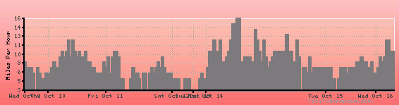
Wind speed
Weather Station: Eastsound, Orcas Island Airport (latitude 48-42-29N, longitude 122-54-37W)
Local Time:
Eastsound is in the "America/Los_Angeles" timezone.
The "America/Los_Angeles" timezone uses a Standard Time (ST) / Daylight Saving Time (DST) alternation scheme, and it currently is in ST (since Sunday, 3 November 2024, 01:00 AM local time). During ST, the timezone abbreviation is PST and the offset to Universal Time (UTC, GMT or Zulu) is -8:00 hours.
Eastsound will exit standard time (entering DST) on Sunday, 9 March 2025, at 02:00 AM local time, when clocks will be turned forward 1 hour to Sunday, 9 March 2025, 03:00 AM local daylight time. During DST, the timezone abbreviation is PDT and the offset to UTC will be -7:00 hours.
Weather and Temperature in Washington
Popular Weather Searches:
 If you own or manage a travel-related business such as a hotel, a bed-and-breakfast, a restaurant, a pub or a cafeteria, you can create a web page for your business for free on Titi Tudorancea Travel Info. » |