| Published in Weather / Nebraska Weather Temperature |
Weather in Columbus, Nebraska
Current Conditions (Monday, February 17, 2025 at 06:14 America/Chicago time)
Temperature: 3°F (-16°C) |
Forecast Overview
Mon Feb 17 
5°F -4°F -15°C -20°C Chance of light snow most of the day.
detailsTue Feb 18 
-0°F -9°F -18°C -23°C Chance of light snow at various times.
detailsWed Feb 19 
3°F -18°F -16°C -28°C Chance of light snow before sunrise.
detailsThu Feb 20 
5°F -22°F -15°C -30°C Mostly sunny.
detailsFri Feb 21 16°F -18°F -9°C -28°C Mostly sunny, with a few passing clouds.
detailsSat Feb 22 
30°F 5°F -1°C -15°C Sunny skies.
detailsSun Feb 23 
36°F 16°F 2°C -9°C Partly cloudy skies.
detailsMon Feb 24 41°F 21°F 5°C -6°C Considerable cloudiness.
detailsTue Feb 25 50°F 36°F 10°C 2°C Partly cloudy skies.
details
Detailed Forecast
| Monday, February 17 | sunrise: 07:23 sunset: 18:04 |
| Low around -4°F (-20°C), high around 5°F (-15°C). Chance of light snow during the morning and early afternoon (between 3 am and 3 pm) and again in the evening (between 6 pm and 9 pm). Estimated precipitation: 0.13 in (3.375 mm). Overcast skies. Wind: 11 mph (18 km/h). |
| Time | Skies | Conditions | Temp | Wind | Humidity | Soil Moisture |
| 00:00 03:00 | Overcast. | 5°F (-15°C) | 4 mph (6 km/h) | 91% | 0.245% | |
| 03:00 06:00 | Chance of light snow. Precipitation: 0.02 in (0.625 mm). | 4°F (-15°C) | 5 mph (9 km/h) | 96% | 0.245% | |
| 06:00 09:00 | Chance of light snow. Precipitation: 0.04 in (0.9375 mm). | 4°F (-16°C) | 9 mph (14 km/h) | 94% | 0.245% | |
| 09:00 12:00 | Chance of light snow. Precipitation: 0.03 in (0.75 mm). | 5°F (-15°C) | 11 mph (17 km/h) | 90% | 0.246% | |
| 12:00 15:00 | Chance of light snow. Precipitation: 0.02 in (0.4375 mm). | 4°F (-15°C) | 11 mph (18 km/h) | 88% | 0.246% | |
| 15:00 18:00 | Overcast. Precipitation: 0.01 in (0.1875 mm). | 1°F (-17°C) | 10 mph (15 km/h) | 93% | 0.247% | |
| 18:00 21:00 | Chance of light snow. Precipitation: 0.01 in (0.1875 mm). | -2°F (-19°C) | 10 mph (15 km/h) | 96% | 0.247% | |
| 21:00 00:00 | Overcast. Precipitation: 0.01 in (0.25 mm). | -4°F (-20°C) | 10 mph (16 km/h) | 90% | 0.248% |
| Tuesday, February 18 | sunrise: 07:22 sunset: 18:05 |
| Low around -10°F (-23°C), high around 0°F (-18°C). Chance of light snow during the morning and early afternoon (between 6 am and 3 pm) and at night (after 9 pm). Estimated precipitation: 0.05 in (1.3125 mm). Overcast skies. Wind: 11 mph (17 km/h). |
| Time | Skies | Conditions | Temp | Wind | Humidity | Soil Moisture |
| 00:00 03:00 | Overcast. | -7°F (-22°C) | 10 mph (16 km/h) | 91% | 0.248% | |
| 03:00 06:00 | Overcast. | -8°F (-22°C) | 11 mph (17 km/h) | 89% | 0.249% | |
| 06:00 09:00 | Chance of light snow. Precipitation: 0 in (0.125 mm). | -7°F (-22°C) | 11 mph (17 km/h) | 92% | 0.249% | |
| 09:00 12:00 | Chance of light snow. Precipitation: 0.02 in (0.625 mm). | -4°F (-20°C) | 10 mph (16 km/h) | 94% | 0.249% | |
| 12:00 15:00 | Chance of light snow. Precipitation: 0.01 in (0.375 mm). | -0°F (-18°C) | 11 mph (17 km/h) | 88% | 0.25% | |
| 15:00 18:00 | Overcast. Precipitation: 0 in (0.125 mm). | -0°F (-18°C) | 9 mph (15 km/h) | 88% | 0.25% | |
| 18:00 21:00 | Overcast. | -2°F (-19°C) | 8 mph (13 km/h) | 88% | 0.251% | |
| 21:00 00:00 | Chance of light snow. Precipitation: 0 in (0.0625 mm). | -1°F (-18°C) | 8 mph (12 km/h) | 93% | 0.251% |
| Wednesday, February 19 | sunrise: 07:20 sunset: 18:06 |
| Low around -19°F (-28°C), high around 3°F (-16°C). Chance of light snow before sunrise (from midnight to 6 am). Estimated precipitation: 0.03 in (0.6875 mm). Partly cloudy skies. Wind: 10 mph (16 km/h). |
| Time | Skies | Conditions | Temp | Wind | Humidity | Soil Moisture |
| 00:00 03:00 | Chance of light snow. Precipitation: 0.02 in (0.4375 mm). | -1°F (-18°C) | 8 mph (13 km/h) | 97% | 0.252% | |
| 03:00 06:00 | Chance of light snow. Precipitation: 0.01 in (0.1875 mm). | -2°F (-19°C) | 8 mph (13 km/h) | 95% | 0.252% | |
| 06:00 09:00 | Overcast. Precipitation: 0 in (0.0625 mm). | -2°F (-19°C) | 9 mph (14 km/h) | 91% | 0.253% | |
| 09:00 12:00 | Overcast. | 2°F (-17°C) | 10 mph (16 km/h) | 81% | 0.253% | |
| 12:00 15:00 | Overcast. | 3°F (-16°C) | 10 mph (16 km/h) | 73% | 0.253% | |
| 15:00 18:00 | Sunny. | -7°F (-21°C) | 5 mph (8 km/h) | 92% | 0.253% | |
| 18:00 21:00 | Clear. | -17°F (-27°C) | 5 mph (7 km/h) | 97% | 0.254% | |
| 21:00 00:00 | Clear. | -18°F (-28°C) | 5 mph (8 km/h) | 98% | 0.254% |
| Thursday, February 20 | sunrise: 07:19 sunset: 18:07 |
| Low around -22°F (-30°C), high around 5°F (-15°C). Mostly sunny. Wind: 5 mph (8 km/h). |
| Time | Skies | Conditions | Temp | Wind | Humidity | Soil Moisture |
| 00:00 03:00 | Clear. | -19°F (-28°C) | 4 mph (7 km/h) | 98% | 0.255% | |
| 03:00 06:00 | Clear. | -21°F (-30°C) | 5 mph (8 km/h) | 99% | 0.255% | |
| 06:00 09:00 | Sunny. | -11°F (-24°C) | 3 mph (5 km/h) | 90% | 0.256% | |
| 09:00 12:00 | A few passing clouds. | 1°F (-17°C) | 3 mph (4 km/h) | 75% | 0.256% | |
| 12:00 15:00 | Partly cloudy. | 5°F (-15°C) | 1 mph (2 km/h) | 69% | 0.256% | |
| 15:00 18:00 | Sunny. | -5°F (-20°C) | 1 mph (1 km/h) | 90% | 0.256% | |
| 18:00 21:00 | Clear. | -14°F (-26°C) | 1 mph (2 km/h) | 97% | 0.257% | |
| 21:00 00:00 | Clear. | -17°F (-27°C) | 2 mph (4 km/h) | 100% | 0.257% |
| Friday, February 21 | sunrise: 07:17 sunset: 18:09 |
| Low around -18°F (-28°C), high around 16°F (-9°C). Mostly sunny, with a few passing clouds. Wind: 12 mph (19 km/h). |
| Time | Skies | Conditions | Temp | Wind | Humidity | Soil Moisture |
| 00:00 03:00 | Times of clear skies and clouds. | -17°F (-27°C) | 3 mph (4 km/h) | 100% | 0.258% | |
| 03:00 06:00 | Mostly cloudy. | -12°F (-25°C) | 3 mph (5 km/h) | 99% | 0.258% | |
| 06:00 09:00 | Sunny. | 0°F (-18°C) | 7 mph (11 km/h) | 92% | 0.259% | |
| 09:00 12:00 | Sunny. | 12°F (-11°C) | 12 mph (19 km/h) | 80% | 0.259% | |
| 12:00 15:00 | Sunny. | 16°F (-9°C) | 12 mph (19 km/h) | 78% | 0.26% | |
| 15:00 18:00 | Sunny. | 12°F (-11°C) | 9 mph (14 km/h) | 88% | 0.26% | |
| 18:00 21:00 | Clear. | 9°F (-13°C) | 9 mph (14 km/h) | 91% | 0.26% | |
| 21:00 00:00 | Clear. | 10°F (-12°C) | 10 mph (16 km/h) | 92% | 0.26% |
| Saturday, February 22 | sunrise: 07:16 sunset: 18:10 |
| Low around 5°F (-15°C), high around 31°F (-1°C). Sunny skies. Wind: 10 mph (17 km/h). |
| Time | Skies | Conditions | Temp | Wind | Humidity | Soil Moisture |
| 00:00 03:00 | Clear. | 8°F (-13°C) | 8 mph (13 km/h) | 95% | 0.26% | |
| 03:00 06:00 | Clear. | 8°F (-13°C) | 7 mph (11 km/h) | 93% | 0.261% | |
| 06:00 09:00 | Sunny. | 13°F (-11°C) | 9 mph (15 km/h) | 91% | 0.261% | |
| 09:00 12:00 | Sunny. | 24°F (-4°C) | 10 mph (16 km/h) | 86% | 0.261% | |
| 12:00 15:00 | Sunny. | 30°F (-1°C) | 10 mph (17 km/h) | 88% | 0.262% | |
| 15:00 18:00 | Sunny. | 25°F (-4°C) | 6 mph (10 km/h) | 94% | 0.262% | |
| 18:00 21:00 | Clear. | 22°F (-6°C) | 8 mph (12 km/h) | 96% | 0.262% | |
| 21:00 00:00 | A few passing clouds. | 20°F (-7°C) | 6 mph (10 km/h) | 97% | 0.262% |
| Sunday, February 23 | sunrise: 07:14 sunset: 18:11 |
| Low around 16°F (-9°C), high around 35°F (2°C). Partly cloudy skies. Wind: 11 mph (18 km/h). |
| Time | Skies | Conditions | Temp | Wind | Humidity | Soil Moisture |
| 00:00 03:00 | Mostly cloudy. | 17°F (-8°C) | 7 mph (11 km/h) | 99% | 0.263% | |
| 03:00 06:00 | A few passing clouds. | 20°F (-7°C) | 5 mph (9 km/h) | 98% | 0.263% | |
| 06:00 09:00 | More sun than clouds. | 26°F (-3°C) | 6 mph (10 km/h) | 91% | 0.263% | |
| 09:00 12:00 | Overcast. | 35°F (1°C) | 11 mph (18 km/h) | 99% | 0.276% | |
| 12:00 15:00 | More clouds than sun. | 35°F (2°C) | 10 mph (16 km/h) | 100% | 0.302% | |
| 15:00 18:00 | Sunny. | 32°F (0°C) | 8 mph (13 km/h) | 94% | 0.311% | |
| 18:00 21:00 | Clear. | 30°F (-1°C) | 8 mph (13 km/h) | 88% | 0.31% | |
| 21:00 00:00 | Mostly cloudy. | 26°F (-4°C) | 6 mph (9 km/h) | 90% | 0.31% |
| Monday, February 24 | sunrise: 07:13 sunset: 18:12 |
| Low around 22°F (-6°C), high around 41°F (5°C). Considerable cloudiness. Wind: 13 mph (20 km/h). |
| Time | Skies | Conditions | Temp | Wind | Humidity | Soil Moisture |
| 00:00 03:00 | Clear. | 24°F (-4°C) | 6 mph (10 km/h) | 90% | 0.31% | |
| 03:00 06:00 | Overcast. | 23°F (-5°C) | 6 mph (10 km/h) | 89% | 0.309% | |
| 06:00 09:00 | Overcast. | 30°F (-1°C) | 7 mph (11 km/h) | 84% | 0.308% | |
| 09:00 12:00 | Overcast. | 38°F (3°C) | 8 mph (14 km/h) | 98% | 0.324% | |
| 12:00 15:00 | Considerable cloudiness. | 40°F (5°C) | 9 mph (14 km/h) | 98% | 0.351% | |
| 15:00 18:00 | Times of sun and clouds. | 38°F (3°C) | 10 mph (16 km/h) | 98% | 0.362% | |
| 18:00 21:00 | Overcast. | 39°F (4°C) | 13 mph (20 km/h) | 81% | 0.362% | |
| 21:00 00:00 | Clear. | 37°F (3°C) | 9 mph (14 km/h) | 86% | 0.363% |
| Tuesday, February 25 | sunrise: 07:11 sunset: 18:13 |
| Low around 35°F (2°C), high around 49°F (10°C). Partly cloudy skies. Wind: 10 mph (17 km/h). |
| Time | Skies | Conditions | Temp | Wind | Humidity | Soil Moisture |
| 00:00 03:00 | Mostly clear, with a few passing clouds. | 37°F (3°C) | 9 mph (14 km/h) | 86% | 0.362% | |
| 03:00 06:00 | Clear. | 35°F (2°C) | 9 mph (14 km/h) | 88% | 0.36% | |
| 06:00 09:00 | Mostly cloudy. | 40°F (4°C) | 10 mph (16 km/h) | 88% | 0.361% | |
| 09:00 12:00 | More sun than clouds. | 46°F (8°C) | 10 mph (17 km/h) | 77% | 0.368% | |
| 12:00 15:00 | Sunny. | 49°F (10°C) | 7 mph (12 km/h) | 64% | 0.365% | |
| 15:00 18:00 | Overcast. | 42°F (5°C) | 3 mph (6 km/h) | 77% | 0.355% | |
| 18:00 21:00 | Partly cloudy. | 38°F (3°C) | 2 mph (3 km/h) | 76% | 0.347% | |
| 21:00 00:00 | Overcast. | 37°F (3°C) | 5 mph (8 km/h) | 81% | 0.343% |
Climate Chart
Places with a similar climate: Albion (NE), York (NE), Fremont (NE), Norfolk (NE), Aurora (NE), Atlantic (IA), Tekamah (NE), Grand Island (NE), Kearney (NE), Sioux City (IA), Creston (IA), Audubon County (IA), Omaha (NE), Hastings (NE), Ord (NE), Red Oak (IA), Denison (IA), Blair City, Washington County (NE), Cherokee (IA), Clarinda (IA), Le Mars (IA), Harlan (IA), Perry City, Dallas County (IA), Omaha (NE), Yankton (SD).
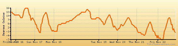
Temperature variation graph for the last seven days
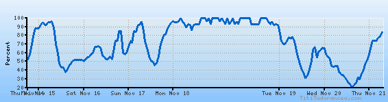
Humidity Variation Graph
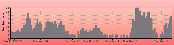
Wind speed
Weather Station: Columbus, Columbus Municipal Airport (latitude 41-27N, longitude 097-20W)
Local Time:
Columbus is in the "America/Chicago" timezone.
The "America/Chicago" timezone uses a Standard Time (ST) / Daylight Saving Time (DST) alternation scheme, and it currently is in ST (since Sunday, 3 November 2024, 01:00 AM local time). During ST, the timezone abbreviation is CST and the offset to Universal Time (UTC, GMT or Zulu) is -6:00 hours.
Columbus will exit standard time (entering DST) on Sunday, 9 March 2025, at 02:00 AM local time, when clocks will be turned forward 1 hour to Sunday, 9 March 2025, 03:00 AM local daylight time. During DST, the timezone abbreviation is CDT and the offset to UTC will be -5:00 hours.
Weather and Temperature in Nebraska
Popular Weather Searches:
 If you own or manage a travel-related business such as a hotel, a bed-and-breakfast, a restaurant, a pub or a cafeteria, you can create a web page for your business for free on Titi Tudorancea Travel Info. » |