| Published in Weather / Massachusetts Weather Temperature |
Weather in Chicopee Falls, Massachusetts
Current Conditions (Monday, February 3, 2025 at 03:55 America/New_York time)
Temperature: 21°F (-6°C) |
Forecast Overview
Mon Feb 3 
39°F 19°F 4°C -7°C Overcast skies.
detailsTue Feb 4 
37°F 16°F 3°C -9°C Chance of light snow in the afternoon.
detailsWed Feb 5 25°F 16°F -4°C -9°C Overcast skies.
detailsThu Feb 6 
30°F 16°F -1°C -9°C Chance of snow in the morning. Chance of freezing rain in the afternoon.
detailsFri Feb 7 
37°F 18°F 3°C -8°C Times of sun and clouds.
detailsSat Feb 8 28°F 16°F -2°C -9°C Chance of snow in the morning and in the afternoon. Chance of ice pellets after 7 pm.
detailsSun Feb 9 36°F 18°F 2°C -8°C Times of sun and clouds.
detailsMon Feb 10 21°F 5°F -6°C -15°C More sun than clouds.
detailsTue Feb 11 23°F 3°F -5°C -16°C Mostly cloudy skies.
details
Detailed Forecast
| Monday, February 3 | sunrise: 07:02 sunset: 17:05 |
| Low around 19°F (-7°C), high around 40°F (4°C). Estimated precipitation: 0.05 in (1.25 mm). Overcast skies. Wind: 9 mph (15 km/h). |
| Time | Skies | Conditions | Temp | Wind | Humidity | Soil Moisture |
| 01:00 04:00 | Considerable cloudiness. Precipitation: 0.02 in (0.5625 mm). | 23°F (-5°C) | 2 mph (3 km/h) | 99% | 0.383% | |
| 04:00 07:00 | Mostly cloudy. | 19°F (-7°C) | 1 mph (2 km/h) | 99% | 0.386% | |
| 07:00 10:00 | Overcast. | 32°F (-0°C) | 2 mph (3 km/h) | 82% | 0.388% | |
| 10:00 13:00 | Overcast. | 38°F (4°C) | 7 mph (12 km/h) | 77% | 0.392% | |
| 13:00 16:00 | Overcast. | 38°F (4°C) | 5 mph (8 km/h) | 91% | 0.396% | |
| 16:00 19:00 | Overcast. Precipitation: 0 in (0.125 mm). | 36°F (2°C) | 9 mph (15 km/h) | 96% | 0.399% | |
| 19:00 22:00 | Overcast. | 37°F (3°C) | 9 mph (15 km/h) | 95% | 0.4% | |
| 22:00 01:00 | Overcast. Precipitation: 0.02 in (0.5625 mm). | 36°F (2°C) | 2 mph (3 km/h) | 99% | 0.406% |
| Tuesday, February 4 | sunrise: 07:01 sunset: 17:07 |
| Low around 17°F (-9°C), high around 38°F (3°C). Chance of light snow early in the afternoon (between 1 pm and 4 pm). Estimated precipitation: 0.01 in (0.1875 mm). More sun than clouds. Wind: 14 mph (22 km/h). |
| Time | Skies | Conditions | Temp | Wind | Humidity | Soil Moisture |
| 01:00 04:00 | Overcast. Precipitation: 0 in (0.0625 mm). | 37°F (3°C) | 8 mph (13 km/h) | 91% | 0.407% | |
| 04:00 07:00 | Partly cloudy. | 31°F (-1°C) | 5 mph (8 km/h) | 92% | 0.407% | |
| 07:00 10:00 | Sunny. | 36°F (2°C) | 11 mph (18 km/h) | 68% | 0.408% | |
| 10:00 13:00 | Overcast. | 33°F (1°C) | 14 mph (22 km/h) | 65% | 0.408% | |
| 13:00 16:00 | Chance of light snow. Precipitation: 0 in (0.0625 mm). | 29°F (-2°C) | 12 mph (20 km/h) | 70% | 0.406% | |
| 16:00 19:00 | Clear. Precipitation: 0 in (0.0625 mm). | 22°F (-6°C) | 12 mph (19 km/h) | 67% | 0.405% | |
| 19:00 22:00 | Clear. | 18°F (-8°C) | 8 mph (13 km/h) | 67% | 0.405% | |
| 22:00 01:00 | Clear. | 17°F (-9°C) | 7 mph (11 km/h) | 67% | 0.406% |
| Wednesday, February 5 | sunrise: 07:00 sunset: 17:08 |
| Low around 16°F (-9°C), high around 25°F (-4°C). Overcast skies. Wind: 10 mph (16 km/h). |
| Time | Skies | Conditions | Temp | Wind | Humidity | Soil Moisture |
| 01:00 04:00 | Mostly cloudy. | 16°F (-9°C) | 5 mph (9 km/h) | 66% | 0.408% | |
| 04:00 07:00 | Overcast. | 16°F (-9°C) | 7 mph (12 km/h) | 65% | 0.41% | |
| 07:00 10:00 | Mostly cloudy. | 20°F (-7°C) | 10 mph (16 km/h) | 50% | 0.411% | |
| 10:00 13:00 | Overcast. | 25°F (-4°C) | 10 mph (16 km/h) | 41% | 0.412% | |
| 13:00 16:00 | Mostly cloudy. | 24°F (-5°C) | 7 mph (12 km/h) | 50% | 0.414% | |
| 16:00 19:00 | Overcast. | 19°F (-7°C) | 3 mph (4 km/h) | 74% | 0.415% | |
| 19:00 22:00 | Mostly cloudy. | 18°F (-8°C) | 2 mph (3 km/h) | 78% | 0.416% | |
| 22:00 01:00 | Overcast. | 16°F (-9°C) | 0 mph (0 km/h) | 83% | 0.418% |
| Thursday, February 6 | sunrise: 06:59 sunset: 17:09 |
| Low around 17°F (-9°C), high around 30°F (-1°C). Chance of snow in the morning (between 7 am and 1 pm). Chance of freezing rain early in the afternoon (between 1 pm and 4 pm). Estimated precipitation: 0.43 in (10.9375 mm). Overcast skies. Wind: 5 mph (7 km/h). |
| Time | Skies | Conditions | Temp | Wind | Humidity | Soil Moisture |
| 01:00 04:00 | Overcast. | 17°F (-8°C) | 1 mph (1 km/h) | 80% | 0.42% | |
| 04:00 07:00 | Overcast. | 18°F (-8°C) | 2 mph (2 km/h) | 78% | 0.422% | |
| 07:00 10:00 | Chance of light snow. Precipitation: 0.04 in (0.9375 mm). | 22°F (-5°C) | 4 mph (7 km/h) | 91% | 0.423% | |
| 10:00 13:00 | Chance of snow. Precipitation: 0.22 in (5.625 mm). | 27°F (-3°C) | 4 mph (6 km/h) | 95% | 0.425% | |
| 13:00 16:00 | Possibly freezing rain leading to formation of glaze ice. Precipitation: 0.16 in (4.1875 mm). | 27°F (-3°C) | 5 mph (7 km/h) | 97% | 0.426% | |
| 16:00 19:00 | Overcast. Precipitation: 0.01 in (0.1875 mm). | 26°F (-3°C) | 1 mph (2 km/h) | 96% | 0.427% | |
| 19:00 22:00 | Overcast. | 27°F (-3°C) | 3 mph (5 km/h) | 97% | 0.428% | |
| 22:00 01:00 | Overcast. | 30°F (-1°C) | 2 mph (3 km/h) | 100% | 0.43% |
| Friday, February 7 | sunrise: 06:58 sunset: 17:10 |
| Low around 18°F (-8°C), high around 37°F (3°C). Estimated precipitation: 0 in (0.0625 mm). Times of sun and clouds. Wind: 11 mph (18 km/h). |
| Time | Skies | Conditions | Temp | Wind | Humidity | Soil Moisture |
| 01:00 04:00 | Overcast. | 32°F (0°C) | 8 mph (12 km/h) | 87% | 0.431% | |
| 04:00 07:00 | Sunny. | 30°F (-1°C) | 11 mph (17 km/h) | 72% | 0.431% | |
| 07:00 10:00 | Mostly cloudy. | 32°F (-0°C) | 11 mph (18 km/h) | 69% | 0.432% | |
| 10:00 13:00 | Mostly cloudy. Precipitation: 0 in (0.0625 mm). | 34°F (1°C) | 11 mph (18 km/h) | 68% | 0.434% | |
| 13:00 16:00 | A few passing clouds. | 31°F (-1°C) | 10 mph (15 km/h) | 71% | 0.434% | |
| 16:00 19:00 | Clear. | 25°F (-4°C) | 8 mph (13 km/h) | 78% | 0.434% | |
| 19:00 22:00 | Clear. | 22°F (-6°C) | 7 mph (12 km/h) | 80% | 0.434% | |
| 22:00 01:00 | Clear. | 18°F (-8°C) | 4 mph (6 km/h) | 91% | 0.434% |
| Saturday, February 8 | sunrise: 06:57 sunset: 17:12 |
| Low around 16°F (-9°C), high around 28°F (-2°C). Chance of snow from 10 am to 7 pm. Chance of ice pellets in the evening (between 7 pm and 10 pm). Estimated precipitation: 0.45 in (11.5 mm). Overcast skies. Wind: 6 mph (10 km/h). |
| Time | Skies | Conditions | Temp | Wind | Humidity | Soil Moisture |
| 01:00 04:00 | Considerable cloudiness. | 18°F (-8°C) | 2 mph (4 km/h) | 90% | 0.434% | |
| 04:00 07:00 | Overcast. | 18°F (-8°C) | 1 mph (2 km/h) | 95% | 0.434% | |
| 07:00 10:00 | Overcast. | 26°F (-4°C) | 1 mph (2 km/h) | 77% | 0.434% | |
| 10:00 13:00 | Chance of light snow. Precipitation: 0.01 in (0.375 mm). | 27°F (-3°C) | 3 mph (6 km/h) | 84% | 0.434% | |
| 13:00 16:00 | Chance of snow. Precipitation: 0.09 in (2.25 mm). | 28°F (-2°C) | 4 mph (6 km/h) | 97% | 0.434% | |
| 16:00 19:00 | Chance of snow. Precipitation: 0.12 in (2.9375 mm). | 26°F (-3°C) | 6 mph (10 km/h) | 96% | 0.434% | |
| 19:00 22:00 | Ice pellets possible. Precipitation: 0.17 in (4.3125 mm). | 26°F (-3°C) | 2 mph (4 km/h) | 97% | 0.434% | |
| 22:00 01:00 | Overcast. Precipitation: 0.06 in (1.625 mm). | 26°F (-3°C) | 4 mph (7 km/h) | 97% | 0.434% |
| Sunday, February 9 | sunrise: 06:55 sunset: 17:13 |
| Low around 17°F (-8°C), high around 35°F (2°C). Times of sun and clouds. Wind: 12 mph (19 km/h). |
| Time | Skies | Conditions | Temp | Wind | Humidity | Soil Moisture |
| 01:00 04:00 | Overcast. | 27°F (-3°C) | 2 mph (3 km/h) | 96% | 0.434% | |
| 04:00 07:00 | Overcast. | 34°F (1°C) | 11 mph (18 km/h) | 83% | 0.434% | |
| 07:00 10:00 | Overcast. | 30°F (-1°C) | 10 mph (16 km/h) | 81% | 0.434% | |
| 10:00 13:00 | Sunny. | 32°F (-0°C) | 12 mph (19 km/h) | 80% | 0.434% | |
| 13:00 16:00 | Sunny. | 29°F (-2°C) | 12 mph (19 km/h) | 78% | 0.434% | |
| 16:00 19:00 | Clear. | 24°F (-5°C) | 9 mph (14 km/h) | 84% | 0.434% | |
| 19:00 22:00 | Clear. | 21°F (-6°C) | 7 mph (12 km/h) | 84% | 0.434% | |
| 22:00 01:00 | Clear. | 18°F (-8°C) | 7 mph (11 km/h) | 84% | 0.434% |
| Monday, February 10 | sunrise: 06:54 sunset: 17:14 |
| Low around 6°F (-15°C), high around 21°F (-6°C). Estimated precipitation: 0 in (0.0625 mm). More sun than clouds. Wind: 13 mph (21 km/h). |
| Time | Skies | Conditions | Temp | Wind | Humidity | Soil Moisture |
| 01:00 04:00 | Clear. | 15°F (-10°C) | 5 mph (8 km/h) | 87% | 0.434% | |
| 04:00 07:00 | Sunny. | 10°F (-12°C) | 4 mph (6 km/h) | 93% | 0.434% | |
| 07:00 10:00 | Partly cloudy. | 19°F (-7°C) | 11 mph (17 km/h) | 64% | 0.434% | |
| 10:00 13:00 | Overcast. | 20°F (-7°C) | 13 mph (21 km/h) | 66% | 0.434% | |
| 13:00 16:00 | Overcast. Precipitation: 0 in (0.0625 mm). | 19°F (-7°C) | 10 mph (16 km/h) | 74% | 0.434% | |
| 16:00 19:00 | Clear. | 14°F (-10°C) | 7 mph (11 km/h) | 82% | 0.434% | |
| 19:00 22:00 | Clear. | 9°F (-13°C) | 2 mph (4 km/h) | 94% | 0.434% | |
| 22:00 01:00 | Clear. | 6°F (-15°C) | 2 mph (3 km/h) | 97% | 0.434% |
| Tuesday, February 11 | sunrise: 06:53 sunset: 17:16 |
| Low around 3°F (-16°C), high around 23°F (-5°C). Mostly cloudy skies. Wind: 6 mph (9 km/h). |
| Time | Skies | Conditions | Temp | Wind | Humidity | Soil Moisture |
| 01:00 04:00 | Mostly clear. | 5°F (-15°C) | 2 mph (3 km/h) | 97% | 0.434% | |
| 04:00 07:00 | Overcast. | 5°F (-15°C) | 2 mph (3 km/h) | 95% | 0.434% | |
| 07:00 10:00 | Overcast. | 14°F (-10°C) | 4 mph (6 km/h) | 71% | 0.434% | |
| 10:00 13:00 | Overcast. | 22°F (-6°C) | 6 mph (9 km/h) | 62% | 0.434% | |
| 13:00 16:00 | Overcast. | 22°F (-6°C) | 6 mph (9 km/h) | 74% | 0.434% | |
| 16:00 19:00 | Clear. | 12°F (-11°C) | 0 mph (1 km/h) | 97% | 0.434% | |
| 19:00 22:00 | Overcast. | 8°F (-13°C) | 1 mph (1 km/h) | 98% | 0.434% | |
| 22:00 01:00 | Overcast. | 8°F (-13°C) | 3 mph (4 km/h) | 97% | 0.434% |
Climate Chart
» Chicopee Falls Climate Chart
Places with a similar climate: Westfield, Barnes (MA), Nashua (NH), Montgomery, Orange County (NY), Sussex (NJ), Dansville (NY), Bedford, Hanscom Field (MA), Poughkeepsie, Dutchess County (NY), New Castle (PA), Norwood (MA), Fitchburg (MA), Danbury (CT), Elmira (NY), North Adams (MA), Washington County (PA), Indiana (PA), Wooster, Wayne County (OH), Butler (PA), Orange (MA), Owosso (MI), Clearfield (PA), Rochester (NH), Marshall (MI), Ann Arbor (MI), Detroit (MI), Mason (MI).
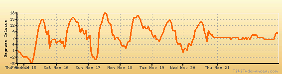
Temperature variation graph for the last seven days
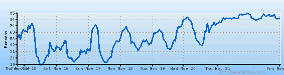
Humidity Variation Graph
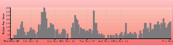
Wind speed
Weather Station: Chicopee Falls / Westover Air Force Base (latitude 42-12N, longitude 072-32W)
Local Time:
Chicopee Falls is in the "America/New_York" timezone.
The "America/New_York" timezone uses a Standard Time (ST) / Daylight Saving Time (DST) alternation scheme, and it currently is in ST (since Sunday, 3 November 2024, 01:00 AM local time). During ST, the timezone abbreviation is EST and the offset to Universal Time (UTC, GMT or Zulu) is -5:00 hours.
Chicopee Falls will exit standard time (entering DST) on Sunday, 9 March 2025, at 02:00 AM local time, when clocks will be turned forward 1 hour to Sunday, 9 March 2025, 03:00 AM local daylight time. During DST, the timezone abbreviation is EDT and the offset to UTC will be -4:00 hours.
Weather and Temperature in Massachusetts
Popular Weather Searches:
 If you own or manage a travel-related business such as a hotel, a bed-and-breakfast, a restaurant, a pub or a cafeteria, you can create a web page for your business for free on Titi Tudorancea Travel Info. » |