| Published in Weather / Illinois Weather Temperature |
Weather in Chicago, Illinois
Current Conditions (Thursday, March 13, 2025 at 12:35 America/Chicago time)
Skies: clear |
Forecast Overview
Fri Mar 14 
64°F 39°F 18°C 4°C Times of sun and clouds.
detailsSat Mar 15 
75°F 52°F 24°C 11°C Chance of heavy rain late at night.
detailsSun Mar 16 
68°F 45°F 20°C 7°C Chance of light rain after 7 pm.
detailsMon Mar 17 
46°F 34°F 8°C 1°C A few passing clouds.
detailsTue Mar 18 
57°F 37°F 14°C 3°C Considerable cloudiness.
detailsWed Mar 19 70°F 46°F 21°C 8°C Mostly cloudy skies.
detailsThu Mar 20 
61°F 34°F 16°C 1°C Chance of rain in the morning. Chance of snow in the afternoon.
detailsFri Mar 21 52°F 30°F 11°C -1°C More clouds than sun.
detailsSat Mar 22 46°F 30°F 8°C -1°C Chance of rain in the morning. Chance of snow in the morning and in the afternoon.
details
Detailed Forecast
| Friday, March 14 | sunrise: 07:05 sunset: 18:54 |
| Low around 40°F (4°C), high around 64°F (18°C). Times of sun and clouds. Wind: 8 mph (13 km/h). |
| Time | Skies | Conditions | Temp | Wind | Humidity | Soil Moisture |
| 01:00 04:00 | Mostly clear. | 40°F (5°C) | 4 mph (6 km/h) | 65% | 0.219% | |
| 04:00 07:00 | Clear. | 40°F (4°C) | 5 mph (7 km/h) | 72% | 0.219% | |
| 07:00 10:00 | Sunny. | 49°F (9°C) | 5 mph (8 km/h) | 47% | 0.219% | |
| 10:00 13:00 | Sunny. | 60°F (16°C) | 6 mph (9 km/h) | 30% | 0.218% | |
| 13:00 16:00 | Considerable cloudiness. | 64°F (18°C) | 5 mph (9 km/h) | 31% | 0.217% | |
| 16:00 19:00 | Clear. | 56°F (13°C) | 5 mph (7 km/h) | 46% | 0.217% | |
| 19:00 22:00 | Clear. | 54°F (12°C) | 8 mph (13 km/h) | 60% | 0.217% | |
| 22:00 01:00 | Overcast. | 52°F (11°C) | 8 mph (13 km/h) | 71% | 0.217% |
| Saturday, March 15 | sunrise: 07:04 sunset: 18:55 |
| Low around 52°F (11°C), high around 75°F (24°C). Chance of heavy rain late at night (after 10 pm). Estimated precipitation: 0.52 in (13.3125 mm). Mostly cloudy skies. Wind: 25 mph (41 km/h). |
| Time | Skies | Conditions | Temp | Wind | Humidity | Soil Moisture |
| 01:00 04:00 | Partly cloudy. Precipitation: 0 in (0.125 mm). | 52°F (11°C) | 8 mph (13 km/h) | 85% | 0.218% | |
| 04:00 07:00 | Overcast. | 54°F (12°C) | 10 mph (16 km/h) | 92% | 0.218% | |
| 07:00 10:00 | Overcast. | 61°F (16°C) | 13 mph (20 km/h) | 76% | 0.218% | |
| 10:00 13:00 | Sunny. | 71°F (22°C) | 17 mph (27 km/h) | 54% | 0.217% | |
| 13:00 16:00 | Sunny. | 75°F (24°C) | 17 mph (27 km/h) | 47% | 0.216% | |
| 16:00 19:00 | Overcast. | 70°F (21°C) | 19 mph (30 km/h) | 58% | 0.215% | |
| 19:00 22:00 | Overcast. | 68°F (20°C) | 23 mph (38 km/h) | 64% | 0.215% | |
| 22:00 01:00 | Chance of heavy rain. Precipitation: 0.52 in (13.1875 mm). | 62°F (17°C) | 25 mph (41 km/h) | 80% | 0.298% |
| Sunday, March 16 | sunrise: 07:02 sunset: 18:56 |
| Low around 45°F (7°C), high around 68°F (20°C). Chance of light rain in the evening (between 7 pm and 10 pm). Estimated precipitation: 0.06 in (1.5 mm). Considerable cloudiness. Wind: 21 mph (34 km/h). |
| Time | Skies | Conditions | Temp | Wind | Humidity | Soil Moisture |
| 01:00 04:00 | Clear. Precipitation: 0.02 in (0.5625 mm). | 63°F (17°C) | 18 mph (29 km/h) | 72% | 0.271% | |
| 04:00 07:00 | Overcast. | 61°F (16°C) | 20 mph (32 km/h) | 50% | 0.262% | |
| 07:00 10:00 | Sunny. | 63°F (17°C) | 21 mph (34 km/h) | 44% | 0.256% | |
| 10:00 13:00 | Overcast. | 67°F (20°C) | 18 mph (29 km/h) | 41% | 0.251% | |
| 13:00 16:00 | Overcast. | 64°F (18°C) | 18 mph (29 km/h) | 48% | 0.247% | |
| 16:00 19:00 | Overcast. | 58°F (15°C) | 12 mph (20 km/h) | 61% | 0.245% | |
| 19:00 22:00 | Chance of light rain. Precipitation: 0.01 in (0.3125 mm). | 50°F (10°C) | 12 mph (19 km/h) | 69% | 0.245% | |
| 22:00 01:00 | Clear. Precipitation: 0.02 in (0.625 mm). | 45°F (7°C) | 12 mph (20 km/h) | 60% | 0.247% |
| Monday, March 17 | sunrise: 07:00 sunset: 18:57 |
| Low around 33°F (1°C), high around 47°F (8°C). Estimated precipitation: 0.01 in (0.1875 mm). A few passing clouds. Wind: 15 mph (24 km/h). |
| Time | Skies | Conditions | Temp | Wind | Humidity | Soil Moisture |
| 01:00 04:00 | Partly cloudy. | 36°F (2°C) | 12 mph (19 km/h) | 62% | 0.244% | |
| 04:00 07:00 | A few passing clouds. | 34°F (1°C) | 11 mph (18 km/h) | 61% | 0.242% | |
| 07:00 10:00 | A few passing clouds. | 36°F (2°C) | 13 mph (21 km/h) | 49% | 0.241% | |
| 10:00 13:00 | Sunny. | 43°F (6°C) | 14 mph (23 km/h) | 31% | 0.238% | |
| 13:00 16:00 | Sunny. | 47°F (8°C) | 15 mph (24 km/h) | 25% | 0.236% | |
| 16:00 19:00 | Clear. | 44°F (7°C) | 10 mph (15 km/h) | 32% | 0.235% | |
| 19:00 22:00 | Overcast. Precipitation: 0 in (0.125 mm). | 42°F (5°C) | 9 mph (15 km/h) | 45% | 0.236% | |
| 22:00 01:00 | Clear. Precipitation: 0 in (0.0625 mm). | 39°F (4°C) | 6 mph (10 km/h) | 57% | 0.235% |
| Tuesday, March 18 | sunrise: 06:59 sunset: 18:58 |
| Low around 37°F (3°C), high around 56°F (14°C). Estimated precipitation: 0 in (0.125 mm). Considerable cloudiness. Wind: 6 mph (9 km/h). |
| Time | Skies | Conditions | Temp | Wind | Humidity | Soil Moisture |
| 01:00 04:00 | Mostly cloudy. | 38°F (3°C) | 5 mph (8 km/h) | 62% | 0.235% | |
| 04:00 07:00 | Overcast. | 37°F (3°C) | 3 mph (5 km/h) | 63% | 0.234% | |
| 07:00 10:00 | Overcast. Precipitation: 0 in (0.125 mm). | 42°F (6°C) | 5 mph (8 km/h) | 54% | 0.235% | |
| 10:00 13:00 | Overcast. | 51°F (11°C) | 6 mph (9 km/h) | 39% | 0.234% | |
| 13:00 16:00 | Overcast. | 56°F (13°C) | 1 mph (1 km/h) | 40% | 0.233% | |
| 16:00 19:00 | Clear. | 47°F (9°C) | 5 mph (8 km/h) | 53% | 0.232% | |
| 19:00 22:00 | Overcast. | 46°F (8°C) | 4 mph (6 km/h) | 56% | 0.232% | |
| 22:00 01:00 | Clear. | 47°F (8°C) | 5 mph (8 km/h) | 65% | 0.232% |
| Wednesday, March 19 | sunrise: 06:57 sunset: 18:59 |
| Low around 47°F (8°C), high around 70°F (21°C). Mostly cloudy skies. Wind: 21 mph (34 km/h). |
| Time | Skies | Conditions | Temp | Wind | Humidity | Soil Moisture |
| 01:00 04:00 | Mostly clear. | 48°F (9°C) | 7 mph (12 km/h) | 86% | 0.232% | |
| 04:00 07:00 | Overcast. | 50°F (10°C) | 10 mph (17 km/h) | 81% | 0.232% | |
| 07:00 10:00 | Overcast. | 56°F (14°C) | 14 mph (23 km/h) | 66% | 0.231% | |
| 10:00 13:00 | Sunny. | 68°F (20°C) | 19 mph (31 km/h) | 46% | 0.229% | |
| 13:00 16:00 | Overcast. | 68°F (20°C) | 20 mph (31 km/h) | 41% | 0.228% | |
| 16:00 19:00 | Overcast. | 63°F (17°C) | 20 mph (32 km/h) | 49% | 0.227% | |
| 19:00 22:00 | Overcast. | 61°F (16°C) | 21 mph (34 km/h) | 59% | 0.228% | |
| 22:00 01:00 | Mostly cloudy. | 60°F (15°C) | 20 mph (32 km/h) | 67% | 0.227% |
| Thursday, March 20 | sunrise: 06:55 sunset: 19:01 |
| Low around 33°F (1°C), high around 61°F (16°C). Chance of rain in the morning (before 4 am and from 7 am to 1 pm). Chance of snow early in the afternoon (between 1 pm and 4 pm). The precipitation may fall as scattered showers of varying intensity. Estimated precipitation: 0.37 in (9.4375 mm). Mostly cloudy skies. Wind: 20 mph (33 km/h). |
| Time | Skies | Conditions | Temp | Wind | Humidity | Soil Moisture |
| 01:00 04:00 | Chance of light rain. Precipitation: 0 in (0.0625 mm). | 59°F (15°C) | 18 mph (30 km/h) | 78% | 0.228% | |
| 04:00 07:00 | Overcast. Precipitation: 0.02 in (0.4375 mm). | 59°F (15°C) | 18 mph (30 km/h) | 79% | 0.231% | |
| 07:00 10:00 | Chance of scattered rain showers. Precipitation: 0.08 in (2 mm). | 61°F (16°C) | 20 mph (33 km/h) | 76% | 0.245% | |
| 10:00 13:00 | Chance of scattered rain showers. Precipitation: 0.23 in (5.8125 mm). | 37°F (3°C) | 19 mph (30 km/h) | 76% | 0.267% | |
| 13:00 16:00 | Chance of light snow. Precipitation: 0.02 in (0.5 mm). | 34°F (1°C) | 14 mph (23 km/h) | 78% | 0.256% | |
| 16:00 19:00 | Overcast. Precipitation: 0.02 in (0.625 mm). | 35°F (2°C) | 12 mph (20 km/h) | 63% | 0.251% | |
| 19:00 22:00 | Overcast. | 35°F (2°C) | 10 mph (16 km/h) | 65% | 0.247% | |
| 22:00 01:00 | Clear. | 33°F (1°C) | 9 mph (14 km/h) | 70% | 0.245% |
| Friday, March 21 | sunrise: 06:53 sunset: 19:02 |
| Low around 31°F (-1°C), high around 52°F (11°C). More clouds than sun. Wind: 15 mph (23 km/h). |
| Time | Skies | Conditions | Temp | Wind | Humidity | Soil Moisture |
| 01:00 04:00 | Clear. | 31°F (-0°C) | 8 mph (13 km/h) | 74% | 0.243% | |
| 04:00 07:00 | Sunny. | 31°F (-1°C) | 9 mph (14 km/h) | 75% | 0.241% | |
| 07:00 10:00 | Sunny. | 39°F (4°C) | 13 mph (20 km/h) | 52% | 0.24% | |
| 10:00 13:00 | Sunny. | 48°F (9°C) | 14 mph (23 km/h) | 40% | 0.239% | |
| 13:00 16:00 | Mostly sunny. | 52°F (11°C) | 15 mph (23 km/h) | 34% | 0.237% | |
| 16:00 19:00 | Overcast. | 49°F (9°C) | 8 mph (13 km/h) | 42% | 0.236% | |
| 19:00 22:00 | Overcast. | 47°F (8°C) | 10 mph (16 km/h) | 49% | 0.235% | |
| 22:00 01:00 | Overcast. | 46°F (8°C) | 12 mph (19 km/h) | 51% | 0.234% |
| Saturday, March 22 | sunrise: 06:52 sunset: 19:03 |
| Low around 30°F (-1°C), high around 46°F (8°C). Chance of rain early in the morning, between 4 am and 10 am. Chance of snow in the morning and early afternoon (between 10 am and 4 pm). Estimated precipitation: 0.39 in (9.875 mm). Overcast skies. Wind: 15 mph (24 km/h). |
| Time | Skies | Conditions | Temp | Wind | Humidity | Soil Moisture |
| 01:00 04:00 | Overcast. Precipitation: 0 in (0.0625 mm). | 45°F (7°C) | 12 mph (19 km/h) | 55% | 0.234% | |
| 04:00 07:00 | Chance of light rain. Precipitation: 0.01 in (0.3125 mm). | 44°F (7°C) | 13 mph (22 km/h) | 66% | 0.237% | |
| 07:00 10:00 | Chance of light rain. Precipitation: 0.03 in (0.875 mm). | 44°F (7°C) | 11 mph (17 km/h) | 75% | 0.241% | |
| 10:00 13:00 | Chance of snow. Precipitation: 0.2 in (5.1875 mm). | 37°F (3°C) | 11 mph (18 km/h) | 94% | 0.274% | |
| 13:00 16:00 | Chance of snow. Precipitation: 0.12 in (2.9375 mm). | 33°F (0°C) | 14 mph (22 km/h) | 93% | 0.265% | |
| 16:00 19:00 | Overcast. Precipitation: 0.02 in (0.5 mm). | 32°F (-0°C) | 15 mph (24 km/h) | 68% | 0.257% | |
| 19:00 22:00 | Clear. | 31°F (-1°C) | 15 mph (24 km/h) | 61% | 0.252% | |
| 22:00 01:00 | Overcast. | 30°F (-1°C) | 14 mph (23 km/h) | 62% | 0.253% |
Climate Chart
Places with a similar climate: Warsaw (IN), Fort Wayne (IN), Joliet (IL), Valparaiso, Porter County (IN), Toledo (OH), Toledo (OH), South Bend (IN), Findlay (OH), Peru, Miami County (IN), Lacon, Marshall County (IL), Lima Allen County (OH), Bloomington/Normal (IL), Defiance (OH), Galesburg (IL), Kirksville (MO), Mount Pleasant (IA), Detroit, Wayne County (MI), Elkhart (IN), Champaign / Urbana (IL), Marion (OH), Peoria (IL), Moline (IL).
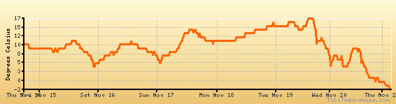
Temperature variation graph for the last seven days
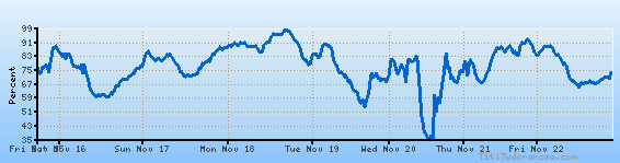
Humidity Variation Graph
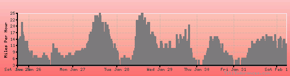
Wind speed
Weather Station: Chicago, Lansing Municipal Airport (latitude 41-32-24N, longitude 087-31-56W)
Local Time:
Chicago is in the "America/Chicago" timezone.
The "America/Chicago" timezone uses a Standard Time (ST) / Daylight Saving Time (DST) alternation scheme, and it currently is in DST (since Sunday, 9 March 2025, 03:00 AM local time). During DST, the timezone abbreviation is CDT and the offset to Universal Time (UTC, GMT or Zulu) is -5:00 hours.
Chicago will exit DST (returning to standard time) on Sunday, 2 November 2025, at 02:00 AM local time, when clocks will be turned backward 1 hour to Sunday, 2 November 2025, 01:00 AM local standard time. During ST, the timezone abbreviation is CST and the offset to UTC will be -6:00 hours.
Weather and Temperature in Illinois
Popular Weather Searches:
 If you own or manage a travel-related business such as a hotel, a bed-and-breakfast, a restaurant, a pub or a cafeteria, you can create a web page for your business for free on Titi Tudorancea Travel Info. » |