| Published in Weather / South Korea Weather Temperature |
Weather in Cheju, Korea, South
Current Conditions (Monday, February 17, 2025 at 12:00 Asia/Seoul time)
Temperature: 43°F (6°C) |
Forecast Overview
Tue Feb 18 
37°F 34°F 3°C 1°C Partly cloudy skies.
detailsWed Feb 19 
37°F 34°F 3°C 1°C Mostly cloudy skies.
detailsThu Feb 20 37°F 32°F 3°C 0°C Considerable cloudiness.
detailsFri Feb 21 37°F 34°F 3°C 1°C Considerable cloudiness.
detailsSat Feb 22 
37°F 34°F 3°C 1°C Chance of light snow at various times.
detailsSun Feb 23 
36°F 34°F 2°C 1°C Chance of light snow in the morning.
detailsMon Feb 24 
43°F 34°F 6°C 1°C More sun than clouds.
detailsTue Feb 25 
48°F 37°F 9°C 3°C Chance of rain after 12 pm.
detailsWed Feb 26 
52°F 43°F 11°C 6°C Chance of rain in the morning.
details
Detailed Forecast
| Monday, February 17 | sunrise: 07:17 sunset: 18:18 |
| Mostly cloudy skies. Wind: 20 mph (32 km/h). |
| Time | Skies | Conditions | Temp | Wind | Humidity | Soil Moisture |
| 12:00 15:00 | Partly cloudy. | 40°F (4°C) | 18 mph (29 km/h) | 53% | 0.279% | |
| 15:00 18:00 | Overcast. | 38°F (3°C) | 20 mph (32 km/h) | 62% | 0.278% | |
| 18:00 21:00 | Overcast. | 35°F (2°C) | 15 mph (25 km/h) | 63% | 0.278% | |
| 21:00 00:00 | Overcast. | 35°F (1°C) | 15 mph (24 km/h) | 64% | 0.278% |
| Tuesday, February 18 | sunrise: 07:16 sunset: 18:19 |
| Low around 34°F (1°C), high around 37°F (3°C). Partly cloudy skies. Wind: 18 mph (29 km/h). |
| Time | Skies | Conditions | Temp | Wind | Humidity | Soil Moisture |
| 00:00 03:00 | Overcast. | 35°F (2°C) | 18 mph (28 km/h) | 63% | 0.278% | |
| 03:00 06:00 | Considerable cloudiness. | 34°F (1°C) | 18 mph (29 km/h) | 62% | 0.278% | |
| 06:00 09:00 | More sun than clouds. | 35°F (2°C) | 16 mph (27 km/h) | 60% | 0.278% | |
| 09:00 12:00 | A few passing clouds. | 37°F (3°C) | 17 mph (27 km/h) | 57% | 0.278% | |
| 12:00 15:00 | Mostly sunny. | 37°F (3°C) | 18 mph (29 km/h) | 58% | 0.276% | |
| 15:00 18:00 | Mostly cloudy. | 35°F (2°C) | 18 mph (29 km/h) | 63% | 0.274% | |
| 18:00 21:00 | Mostly cloudy. | 35°F (2°C) | 18 mph (28 km/h) | 64% | 0.274% | |
| 21:00 00:00 | Considerable cloudiness. | 35°F (2°C) | 17 mph (27 km/h) | 66% | 0.274% |
| Wednesday, February 19 | sunrise: 07:15 sunset: 18:20 |
| Low around 34°F (1°C), high around 37°F (3°C). Mostly cloudy skies. Wind: 18 mph (29 km/h). |
| Time | Skies | Conditions | Temp | Wind | Humidity | Soil Moisture |
| 00:00 03:00 | Mostly cloudy. | 35°F (2°C) | 18 mph (29 km/h) | 66% | 0.275% | |
| 03:00 06:00 | Considerable cloudiness. | 34°F (1°C) | 18 mph (28 km/h) | 64% | 0.275% | |
| 06:00 09:00 | More sun than clouds. | 35°F (2°C) | 17 mph (27 km/h) | 60% | 0.276% | |
| 09:00 12:00 | More sun than clouds. | 36°F (2°C) | 16 mph (25 km/h) | 58% | 0.275% | |
| 12:00 15:00 | Overcast. | 36°F (2°C) | 15 mph (24 km/h) | 59% | 0.273% | |
| 15:00 18:00 | Overcast. | 35°F (2°C) | 14 mph (22 km/h) | 63% | 0.271% | |
| 18:00 21:00 | Overcast. | 34°F (1°C) | 13 mph (20 km/h) | 66% | 0.271% | |
| 21:00 00:00 | Overcast. | 34°F (1°C) | 12 mph (19 km/h) | 67% | 0.271% |
| Thursday, February 20 | sunrise: 07:14 sunset: 18:21 |
| Low around 33°F (0°C), high around 37°F (3°C). Considerable cloudiness. Wind: 12 mph (19 km/h). |
| Time | Skies | Conditions | Temp | Wind | Humidity | Soil Moisture |
| 00:00 03:00 | Overcast. | 34°F (1°C) | 11 mph (18 km/h) | 68% | 0.272% | |
| 03:00 06:00 | Partly cloudy. | 33°F (1°C) | 11 mph (18 km/h) | 69% | 0.272% | |
| 06:00 09:00 | A few passing clouds. | 34°F (1°C) | 10 mph (16 km/h) | 64% | 0.273% | |
| 09:00 12:00 | Mostly sunny, with a few passing clouds. | 37°F (3°C) | 11 mph (18 km/h) | 61% | 0.273% | |
| 12:00 15:00 | Overcast. | 37°F (3°C) | 11 mph (18 km/h) | 59% | 0.27% | |
| 15:00 18:00 | Overcast. | 35°F (2°C) | 11 mph (17 km/h) | 61% | 0.268% | |
| 18:00 21:00 | Overcast. | 35°F (2°C) | 11 mph (18 km/h) | 63% | 0.267% | |
| 21:00 00:00 | Overcast. | 35°F (2°C) | 12 mph (19 km/h) | 65% | 0.268% |
| Friday, February 21 | sunrise: 07:13 sunset: 18:22 |
| Low around 33°F (1°C), high around 37°F (3°C). Considerable cloudiness. Wind: 15 mph (24 km/h). |
| Time | Skies | Conditions | Temp | Wind | Humidity | Soil Moisture |
| 00:00 03:00 | Overcast. | 35°F (1°C) | 13 mph (20 km/h) | 67% | 0.269% | |
| 03:00 06:00 | Overcast. | 34°F (1°C) | 13 mph (22 km/h) | 69% | 0.269% | |
| 06:00 09:00 | Times of sun and clouds. | 34°F (1°C) | 13 mph (21 km/h) | 67% | 0.27% | |
| 09:00 12:00 | Sunny. | 36°F (2°C) | 13 mph (21 km/h) | 60% | 0.269% | |
| 12:00 15:00 | Sunny. | 37°F (3°C) | 14 mph (22 km/h) | 53% | 0.266% | |
| 15:00 18:00 | Overcast. | 35°F (2°C) | 15 mph (24 km/h) | 59% | 0.264% | |
| 18:00 21:00 | Overcast. | 35°F (1°C) | 13 mph (21 km/h) | 63% | 0.263% | |
| 21:00 00:00 | Overcast. | 34°F (1°C) | 12 mph (20 km/h) | 65% | 0.264% |
| Saturday, February 22 | sunrise: 07:12 sunset: 18:23 |
| Low around 34°F (1°C), high around 37°F (3°C). Chance of light snow early in the morning (between 6 am and 9 am) and in the evening (after 6 pm). Estimated precipitation: 0.01 in (0.375 mm). Mostly cloudy skies. Wind: 20 mph (33 km/h). |
| Time | Skies | Conditions | Temp | Wind | Humidity | Soil Moisture |
| 00:00 03:00 | Overcast. | 34°F (1°C) | 13 mph (21 km/h) | 66% | 0.265% | |
| 03:00 06:00 | Overcast. Precipitation: 0 in (0.0625 mm). | 35°F (1°C) | 15 mph (24 km/h) | 62% | 0.265% | |
| 06:00 09:00 | Chance of light snow. Precipitation: 0 in (0.0625 mm). | 36°F (2°C) | 18 mph (29 km/h) | 66% | 0.267% | |
| 09:00 12:00 | Overcast. Precipitation: 0 in (0.125 mm). | 37°F (3°C) | 20 mph (33 km/h) | 58% | 0.268% | |
| 12:00 15:00 | Mostly sunny. | 36°F (2°C) | 19 mph (31 km/h) | 53% | 0.266% | |
| 15:00 18:00 | Mostly cloudy. | 35°F (2°C) | 19 mph (30 km/h) | 58% | 0.263% | |
| 18:00 21:00 | Chance of light snow. Precipitation: 0 in (0.0625 mm). | 35°F (2°C) | 17 mph (28 km/h) | 59% | 0.263% | |
| 21:00 00:00 | Chance of light snow. Precipitation: 0 in (0.0625 mm). | 35°F (1°C) | 17 mph (28 km/h) | 57% | 0.263% |
| Sunday, February 23 | sunrise: 07:11 sunset: 18:24 |
| Low around 33°F (1°C), high around 36°F (2°C). Chance of light snow in the morning (before 3 am and from 6 am to 12 pm). Estimated precipitation: 0.06 in (1.625 mm). Mostly cloudy skies. Wind: 21 mph (33 km/h). |
| Time | Skies | Conditions | Temp | Wind | Humidity | Soil Moisture |
| 00:00 03:00 | Chance of light snow. Precipitation: 0.01 in (0.3125 mm). | 34°F (1°C) | 19 mph (31 km/h) | 69% | 0.265% | |
| 03:00 06:00 | Overcast. Precipitation: 0.02 in (0.5625 mm). | 34°F (1°C) | 21 mph (33 km/h) | 65% | 0.266% | |
| 06:00 09:00 | Chance of light snow. Precipitation: 0.01 in (0.375 mm). | 34°F (1°C) | 20 mph (32 km/h) | 63% | 0.267% | |
| 09:00 12:00 | Chance of light snow. Precipitation: 0.01 in (0.25 mm). | 35°F (2°C) | 21 mph (33 km/h) | 55% | 0.269% | |
| 12:00 15:00 | Mostly cloudy. Precipitation: 0 in (0.0625 mm). | 36°F (2°C) | 20 mph (33 km/h) | 55% | 0.268% | |
| 15:00 18:00 | Overcast. Precipitation: 0 in (0.0625 mm). | 35°F (2°C) | 19 mph (31 km/h) | 60% | 0.267% | |
| 18:00 21:00 | Partly cloudy. | 35°F (2°C) | 17 mph (27 km/h) | 63% | 0.267% | |
| 21:00 00:00 | Partly cloudy. | 34°F (1°C) | 13 mph (21 km/h) | 68% | 0.267% |
| Monday, February 24 | sunrise: 07:10 sunset: 18:25 |
| Low around 34°F (1°C), high around 42°F (6°C). More sun than clouds. Wind: 10 mph (16 km/h). |
| Time | Skies | Conditions | Temp | Wind | Humidity | Soil Moisture |
| 00:00 03:00 | A few passing clouds. | 34°F (1°C) | 10 mph (16 km/h) | 73% | 0.268% | |
| 03:00 06:00 | Clear. | 34°F (1°C) | 8 mph (13 km/h) | 75% | 0.268% | |
| 06:00 09:00 | Sunny. | 37°F (3°C) | 8 mph (13 km/h) | 68% | 0.27% | |
| 09:00 12:00 | Sunny. | 40°F (5°C) | 7 mph (12 km/h) | 60% | 0.269% | |
| 12:00 15:00 | Sunny. | 42°F (5°C) | 8 mph (12 km/h) | 57% | 0.265% | |
| 15:00 18:00 | More clouds than sun. | 40°F (4°C) | 5 mph (7 km/h) | 64% | 0.263% | |
| 18:00 21:00 | Overcast. | 39°F (4°C) | 3 mph (5 km/h) | 70% | 0.263% | |
| 21:00 00:00 | Overcast. | 38°F (4°C) | 3 mph (5 km/h) | 72% | 0.263% |
| Tuesday, February 25 | sunrise: 07:09 sunset: 18:25 |
| Low around 38°F (3°C), high around 48°F (9°C). Chance of rain from 12 pm till midnight. Estimated precipitation: 0.34 in (8.5625 mm). Overcast skies. Wind: 6 mph (10 km/h). |
| Time | Skies | Conditions | Temp | Wind | Humidity | Soil Moisture |
| 00:00 03:00 | Considerable cloudiness. | 38°F (4°C) | 2 mph (4 km/h) | 70% | 0.264% | |
| 03:00 06:00 | Overcast. | 38°F (3°C) | 3 mph (4 km/h) | 70% | 0.264% | |
| 06:00 09:00 | Overcast. | 41°F (5°C) | 5 mph (8 km/h) | 62% | 0.265% | |
| 09:00 12:00 | Overcast. | 47°F (8°C) | 6 mph (9 km/h) | 60% | 0.263% | |
| 12:00 15:00 | Chance of light rain. Precipitation: 0.02 in (0.4375 mm). | 45°F (7°C) | 3 mph (5 km/h) | 76% | 0.266% | |
| 15:00 18:00 | Chance of rain. Precipitation: 0.14 in (3.5 mm). | 43°F (6°C) | 2 mph (4 km/h) | 87% | 0.293% | |
| 18:00 21:00 | Chance of rain. Precipitation: 0.1 in (2.625 mm). | 44°F (6°C) | 6 mph (10 km/h) | 90% | 0.301% | |
| 21:00 00:00 | Chance of rain. Precipitation: 0.08 in (2 mm). | 45°F (7°C) | 6 mph (10 km/h) | 90% | 0.301% |
| Wednesday, February 26 | sunrise: 07:08 sunset: 18:26 |
| Low around 44°F (6°C), high around 53°F (11°C). Chance of rain early in the morning, between 3 am and 9 am. Estimated precipitation: 0.15 in (3.875 mm). Overcast skies. Wind: 13 mph (20 km/h). |
| Time | Skies | Conditions | Temp | Wind | Humidity | Soil Moisture |
| 00:00 03:00 | Overcast. Precipitation: 0.04 in (1.0625 mm). | 47°F (8°C) | 8 mph (13 km/h) | 92% | 0.294% | |
| 03:00 06:00 | Chance of rain. Precipitation: 0.08 in (2 mm). | 47°F (8°C) | 13 mph (20 km/h) | 95% | 0.297% | |
| 06:00 09:00 | Chance of light rain. Precipitation: 0.02 in (0.4375 mm). | 47°F (8°C) | 12 mph (20 km/h) | 93% | 0.293% | |
| 09:00 12:00 | Mostly cloudy. Precipitation: 0 in (0.125 mm). | 50°F (10°C) | 12 mph (19 km/h) | 90% | 0.289% | |
| 12:00 15:00 | Overcast. Precipitation: 0 in (0.125 mm). | 52°F (11°C) | 10 mph (17 km/h) | 89% | 0.287% | |
| 15:00 18:00 | Overcast. | 51°F (11°C) | 10 mph (17 km/h) | 92% | 0.285% | |
| 18:00 21:00 | Overcast. Precipitation: 0 in (0.0625 mm). | 52°F (11°C) | 10 mph (15 km/h) | 94% | 0.285% | |
| 21:00 00:00 | Overcast. Precipitation: 0 in (0.0625 mm). | 52°F (11°C) | 9 mph (15 km/h) | 95% | 0.284% |
Climate Chart
Places with a similar climate: Iwami (Japan), Tottori (Japan), Hofu (Japan), Tsushima (Japan), Ube, Yamaguchi (Japan), Nagoya (Japan), Tokyo (Japan), Ashiya (Japan), Iwakuni (Japan), Kitakyushu (Japan), Oita (Japan), Izumo (Japan), Takamatsu (Japan), Kobe (Japan), Matsuyama (Japan), Miho (Japan), Capo Mele (Italy), Hiroshima (Japan).
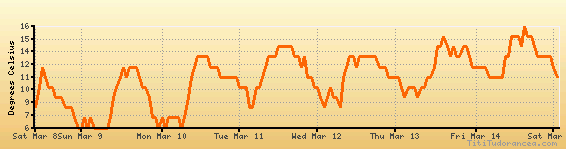
Temperature variation graph for the last seven days
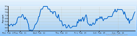
Humidity Variation Graph
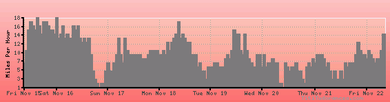
Wind speed
Weather Station: Cheju International Airport (latitude 33-30N, longitude 126-30E)
Local Time:
Cheju is in the "Asia/Seoul" timezone, commonly abbreviated KST.
This timezone does not apply the Daylight Saving Time (DST) scheme - it uses standard time throughout the year. The offset to Universal Time (UTC, GMT or Zulu) is +9:00 hours.
Weather and Temperature in Korea, South
Popular Weather Searches:
 If you own or manage a travel-related business such as a hotel, a bed-and-breakfast, a restaurant, a pub or a cafeteria, you can create a web page for your business for free on Titi Tudorancea Travel Info. » |