| Published in Weather / Utah Weather Temperature |
Weather in Cedar City, Utah
Current Conditions (Friday, March 28, 2025 at 14:53 America/Denver time)
Temperature: 61°F (16°C) |
Forecast Overview
Sat Mar 29 
45°F 32°F 7°C -0°C Chance of snow in the morning and in the afternoon.
detailsSun Mar 30 
50°F 32°F 10°C -0°C Chance of light snow before sunrise.
detailsMon Mar 31 
52°F 36°F 11°C 2°C Mostly cloudy skies.
detailsTue Apr 1 
43°F 32°F 6°C -0°C Chance of light rain before sunrise. Chance of light snow all day.
detailsWed Apr 2 37°F 25°F 3°C -4°C Chance of light snow at various times of the day.
detailsThu Apr 3 
39°F 23°F 4°C -5°C Mostly cloudy skies.
detailsFri Apr 4 
45°F 27°F 7°C -3°C A few passing clouds.
detailsSat Apr 5 
52°F 28°F 11°C -2°C Sunny skies.
detailsSun Apr 6 59°F 32°F 15°C 0°C More clouds than sun.
details
Detailed Forecast
| Friday, March 28 | sunrise: 07:25 sunset: 19:50 |
| Overcast skies. Wind: 11 mph (18 km/h). |
| Time | Skies | Conditions | Temp | Wind | Humidity | Soil Moisture |
| 15:00 18:00 | Overcast. | 50°F (10°C) | 11 mph (18 km/h) | 23% | 0.157% | |
| 18:00 21:00 | Overcast. | 43°F (6°C) | 6 mph (10 km/h) | 36% | 0.157% | |
| 21:00 00:00 | Overcast. | 42°F (6°C) | 4 mph (6 km/h) | 39% | 0.157% |
| Saturday, March 29 | sunrise: 07:24 sunset: 19:51 |
| Low around 31°F (-0°C), high around 45°F (7°C). Chance of snow from 9 am to 6 pm. The precipitation may fall as scattered showers of varying intensity. Estimated precipitation: 0.41 in (10.5 mm). Considerable cloudiness. Wind: 11 mph (18 km/h). |
| Time | Skies | Conditions | Temp | Wind | Humidity | Soil Moisture |
| 00:00 03:00 | Considerable cloudiness. | 40°F (4°C) | 6 mph (9 km/h) | 45% | 0.157% | |
| 03:00 06:00 | Overcast. | 38°F (3°C) | 6 mph (10 km/h) | 50% | 0.157% | |
| 06:00 09:00 | Overcast. | 42°F (6°C) | 3 mph (4 km/h) | 43% | 0.158% | |
| 09:00 12:00 | Chance of snow. Precipitation: 0.04 in (1.0625 mm). | 41°F (5°C) | 9 mph (15 km/h) | 67% | 0.165% | |
| 12:00 15:00 | Chance of snow. Precipitation: 0.26 in (6.5 mm). | 41°F (5°C) | 11 mph (18 km/h) | 67% | 0.202% | |
| 15:00 18:00 | Chance of scattered snow showers. Precipitation: 0.11 in (2.6875 mm). | 37°F (3°C) | 9 mph (15 km/h) | 86% | 0.228% | |
| 18:00 21:00 | Clear. Precipitation: 0.01 in (0.25 mm). | 33°F (1°C) | 4 mph (6 km/h) | 80% | 0.23% | |
| 21:00 00:00 | Clear. | 32°F (-0°C) | 4 mph (7 km/h) | 79% | 0.228% |
| Sunday, March 30 | sunrise: 07:22 sunset: 19:52 |
| Low around 31°F (-0°C), high around 51°F (10°C). Chance of light snow before sunrise (between 3 am and 6 am). Estimated precipitation: 0.01 in (0.25 mm). Partly cloudy skies. Wind: 12 mph (19 km/h). |
| Time | Skies | Conditions | Temp | Wind | Humidity | Soil Moisture |
| 00:00 03:00 | Overcast. | 34°F (1°C) | 4 mph (6 km/h) | 75% | 0.227% | |
| 03:00 06:00 | Chance of light snow. Precipitation: 0 in (0.0625 mm). | 32°F (0°C) | 5 mph (8 km/h) | 65% | 0.226% | |
| 06:00 09:00 | Overcast. Precipitation: 0 in (0.125 mm). | 38°F (3°C) | 2 mph (3 km/h) | 53% | 0.225% | |
| 09:00 12:00 | Considerable cloudiness. Precipitation: 0 in (0.0625 mm). | 45°F (7°C) | 6 mph (10 km/h) | 36% | 0.226% | |
| 12:00 15:00 | Mostly cloudy. | 50°F (10°C) | 8 mph (14 km/h) | 30% | 0.227% | |
| 15:00 18:00 | Sunny. | 49°F (9°C) | 12 mph (19 km/h) | 33% | 0.225% | |
| 18:00 21:00 | Times of clear skies and clouds. | 40°F (5°C) | 9 mph (15 km/h) | 49% | 0.223% | |
| 21:00 00:00 | Clear. | 39°F (4°C) | 10 mph (16 km/h) | 50% | 0.222% |
| Monday, March 31 | sunrise: 07:21 sunset: 19:53 |
| Low around 36°F (2°C), high around 52°F (11°C). Mostly cloudy skies. Wind: 13 mph (21 km/h). |
| Time | Skies | Conditions | Temp | Wind | Humidity | Soil Moisture |
| 00:00 03:00 | Clear. | 37°F (3°C) | 8 mph (13 km/h) | 51% | 0.221% | |
| 03:00 06:00 | Overcast. | 37°F (3°C) | 8 mph (13 km/h) | 53% | 0.22% | |
| 06:00 09:00 | Overcast. | 43°F (6°C) | 7 mph (11 km/h) | 54% | 0.219% | |
| 09:00 12:00 | Overcast. | 49°F (9°C) | 13 mph (21 km/h) | 37% | 0.218% | |
| 12:00 15:00 | Overcast. | 52°F (11°C) | 13 mph (21 km/h) | 37% | 0.216% | |
| 15:00 18:00 | Overcast. | 52°F (11°C) | 10 mph (17 km/h) | 32% | 0.214% | |
| 18:00 21:00 | Considerable cloudiness. | 42°F (6°C) | 8 mph (13 km/h) | 55% | 0.213% | |
| 21:00 00:00 | Overcast. | 41°F (5°C) | 8 mph (12 km/h) | 72% | 0.212% |
| Tuesday, April 1 | sunrise: 07:19 sunset: 19:54 |
| Low around 31°F (-0°C), high around 43°F (6°C). Chance of light rain before sunrise (between 3 am and 6 am). Chance of light snow most of the day (after 6 am). Estimated precipitation: 0.16 in (3.9375 mm). Overcast skies. Wind: 14 mph (23 km/h). |
| Time | Skies | Conditions | Temp | Wind | Humidity | Soil Moisture |
| 00:00 03:00 | Mostly clear, with a few passing clouds. | 38°F (4°C) | 9 mph (14 km/h) | 78% | 0.211% | |
| 03:00 06:00 | Chance of light rain. Precipitation: 0.01 in (0.25 mm). | 36°F (2°C) | 7 mph (12 km/h) | 83% | 0.212% | |
| 06:00 09:00 | Chance of light snow. Precipitation: 0.04 in (0.9375 mm). | 40°F (4°C) | 9 mph (14 km/h) | 67% | 0.219% | |
| 09:00 12:00 | Chance of light snow. Precipitation: 0.01 in (0.375 mm). | 42°F (6°C) | 10 mph (17 km/h) | 48% | 0.222% | |
| 12:00 15:00 | Chance of light snow. Precipitation: 0.03 in (0.6875 mm). | 37°F (3°C) | 9 mph (14 km/h) | 75% | 0.221% | |
| 15:00 18:00 | Chance of light snow. Precipitation: 0.03 in (0.8125 mm). | 36°F (2°C) | 3 mph (4 km/h) | 68% | 0.222% | |
| 18:00 21:00 | Chance of light snow. Precipitation: 0.03 in (0.75 mm). | 33°F (0°C) | 14 mph (23 km/h) | 75% | 0.224% | |
| 21:00 00:00 | Chance of light snow. Precipitation: 0 in (0.125 mm). | 34°F (1°C) | 2 mph (3 km/h) | 55% | 0.223% |
| Wednesday, April 2 | sunrise: 07:18 sunset: 19:55 |
| Low around 25°F (-4°C), high around 38°F (3°C). Chance of light snow between 9 am and 12 pm and between 3 pm and 9 pm. Estimated precipitation: 0.12 in (3.125 mm). Partly cloudy skies. Wind: 16 mph (26 km/h). |
| Time | Skies | Conditions | Temp | Wind | Humidity | Soil Moisture |
| 00:00 03:00 | Mostly cloudy. | 29°F (-2°C) | 5 mph (8 km/h) | 62% | 0.221% | |
| 03:00 06:00 | Clear. | 26°F (-3°C) | 4 mph (7 km/h) | 60% | 0.221% | |
| 06:00 09:00 | More sun than clouds. | 33°F (1°C) | 3 mph (5 km/h) | 40% | 0.221% | |
| 09:00 12:00 | Chance of light snow. Precipitation: 0.01 in (0.1875 mm). | 37°F (3°C) | 10 mph (17 km/h) | 33% | 0.223% | |
| 12:00 15:00 | Overcast. Precipitation: 0.04 in (0.9375 mm). | 35°F (2°C) | 9 mph (15 km/h) | 45% | 0.228% | |
| 15:00 18:00 | Chance of light snow. Precipitation: 0.02 in (0.4375 mm). | 36°F (2°C) | 16 mph (26 km/h) | 34% | 0.23% | |
| 18:00 21:00 | Chance of snow. Precipitation: 0.04 in (1 mm). | 30°F (-1°C) | 6 mph (9 km/h) | 61% | 0.231% | |
| 21:00 00:00 | Clear. Precipitation: 0.02 in (0.5625 mm). | 25°F (-4°C) | 3 mph (5 km/h) | 71% | 0.231% |
| Thursday, April 3 | sunrise: 07:16 sunset: 19:56 |
| Low around 22°F (-5°C), high around 40°F (4°C). Mostly cloudy skies. Wind: 7 mph (11 km/h). |
| Time | Skies | Conditions | Temp | Wind | Humidity | Soil Moisture |
| 00:00 03:00 | Clear. | 24°F (-4°C) | 4 mph (7 km/h) | 67% | 0.231% | |
| 03:00 06:00 | Times of clear skies and clouds. | 23°F (-5°C) | 3 mph (5 km/h) | 66% | 0.232% | |
| 06:00 09:00 | A few passing clouds. | 30°F (-1°C) | 1 mph (2 km/h) | 54% | 0.232% | |
| 09:00 12:00 | Overcast. | 36°F (2°C) | 5 mph (8 km/h) | 35% | 0.234% | |
| 12:00 15:00 | Overcast. | 39°F (4°C) | 6 mph (9 km/h) | 26% | 0.234% | |
| 15:00 18:00 | Overcast. | 40°F (4°C) | 4 mph (7 km/h) | 24% | 0.232% | |
| 18:00 21:00 | Overcast. | 32°F (0°C) | 7 mph (11 km/h) | 45% | 0.231% | |
| 21:00 00:00 | Overcast. | 31°F (-1°C) | 5 mph (8 km/h) | 46% | 0.23% |
| Friday, April 4 | sunrise: 07:15 sunset: 19:56 |
| Low around 26°F (-3°C), high around 44°F (7°C). A few passing clouds. Wind: 17 mph (27 km/h). |
| Time | Skies | Conditions | Temp | Wind | Humidity | Soil Moisture |
| 00:00 03:00 | Mostly cloudy. | 29°F (-2°C) | 4 mph (6 km/h) | 48% | 0.231% | |
| 03:00 06:00 | Clear. | 27°F (-3°C) | 4 mph (6 km/h) | 52% | 0.231% | |
| 06:00 09:00 | Sunny. | 34°F (1°C) | 4 mph (7 km/h) | 35% | 0.231% | |
| 09:00 12:00 | Sunny. | 42°F (5°C) | 10 mph (17 km/h) | 24% | 0.231% | |
| 12:00 15:00 | Overcast. | 43°F (6°C) | 17 mph (27 km/h) | 24% | 0.229% | |
| 15:00 18:00 | Sunny. | 42°F (6°C) | 15 mph (24 km/h) | 24% | 0.226% | |
| 18:00 21:00 | Clear. | 33°F (1°C) | 8 mph (13 km/h) | 35% | 0.225% | |
| 21:00 00:00 | Clear. | 31°F (-1°C) | 6 mph (9 km/h) | 47% | 0.224% |
| Saturday, April 5 | sunrise: 07:13 sunset: 19:57 |
| Low around 28°F (-2°C), high around 52°F (11°C). Sunny skies. Wind: 10 mph (17 km/h). |
| Time | Skies | Conditions | Temp | Wind | Humidity | Soil Moisture |
| 00:00 03:00 | Clear. | 29°F (-2°C) | 3 mph (5 km/h) | 52% | 0.224% | |
| 03:00 06:00 | Clear. | 28°F (-2°C) | 4 mph (7 km/h) | 56% | 0.225% | |
| 06:00 09:00 | Sunny. | 35°F (2°C) | 5 mph (8 km/h) | 44% | 0.225% | |
| 09:00 12:00 | Sunny. | 45°F (7°C) | 8 mph (13 km/h) | 34% | 0.224% | |
| 12:00 15:00 | Sunny. | 52°F (11°C) | 9 mph (14 km/h) | 23% | 0.222% | |
| 15:00 18:00 | Sunny. | 50°F (10°C) | 10 mph (17 km/h) | 28% | 0.219% | |
| 18:00 21:00 | Clear. | 40°F (4°C) | 3 mph (5 km/h) | 44% | 0.217% | |
| 21:00 00:00 | Clear. | 37°F (3°C) | 3 mph (5 km/h) | 48% | 0.217% |
| Sunday, April 6 | sunrise: 07:12 sunset: 19:58 |
| Low around 32°F (0°C), high around 59°F (15°C). More clouds than sun. Wind: 6 mph (10 km/h). |
| Time | Skies | Conditions | Temp | Wind | Humidity | Soil Moisture |
| 00:00 03:00 | Clear. | 36°F (2°C) | 6 mph (10 km/h) | 44% | 0.216% | |
| 03:00 06:00 | Clear. | 33°F (1°C) | 2 mph (3 km/h) | 45% | 0.215% | |
| 06:00 09:00 | Sunny. | 41°F (5°C) | 2 mph (3 km/h) | 34% | 0.215% | |
| 09:00 12:00 | A few passing clouds. | 51°F (11°C) | 6 mph (9 km/h) | 27% | 0.213% | |
| 12:00 15:00 | Partly cloudy. | 57°F (14°C) | 6 mph (9 km/h) | 23% | 0.208% | |
| 15:00 18:00 | Overcast. | 58°F (14°C) | 6 mph (10 km/h) | 22% | 0.204% | |
| 18:00 21:00 | Overcast. | 48°F (9°C) | 4 mph (6 km/h) | 30% | 0.203% | |
| 21:00 00:00 | Overcast. | 45°F (7°C) | 5 mph (8 km/h) | 33% | 0.202% |
Climate Chart
Places with a similar climate: Milford (UT), Montrose (CO), Las Vegas, Tonopah Range (NV), Fort Collins/Loveland (CO), Tonopah (NV), Rome (OR), Fort Carson (CO), Denver (CO).
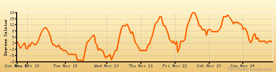
Temperature variation graph for the last seven days
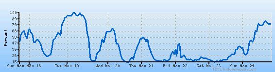
Humidity Variation Graph
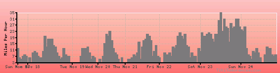
Wind speed
Weather Station: Cedar City, Cedar City Municipal Airport (latitude 37-42-24N, longitude 113-05-48W)
Local Time:
Cedar City is in the "America/Denver" timezone.
The "America/Denver" timezone uses a Standard Time (ST) / Daylight Saving Time (DST) alternation scheme, and it currently is in DST (since Sunday, 9 March 2025, 03:00 AM local time). During DST, the timezone abbreviation is MDT and the offset to Universal Time (UTC, GMT or Zulu) is -6:00 hours.
Cedar City will exit DST (returning to standard time) on Sunday, 2 November 2025, at 02:00 AM local time, when clocks will be turned backward 1 hour to Sunday, 2 November 2025, 01:00 AM local standard time. During ST, the timezone abbreviation is MST and the offset to UTC will be -7:00 hours.
Weather and Temperature in Utah
Popular Weather Searches:
 If you own or manage a travel-related business such as a hotel, a bed-and-breakfast, a restaurant, a pub or a cafeteria, you can create a web page for your business for free on Titi Tudorancea Travel Info. » |