| Published in Weather / Illinois Weather Temperature |
Weather in Bloomington/Normal, Illinois
Current Conditions (Saturday, February 15, 2025 at 09:56 America/Chicago time)
Temperature: 36°F (2°C) |
Forecast Overview
Sun Feb 16 
34°F 27°F 1°C -3°C Chance of snow after 3 pm.
detailsMon Feb 17 
27°F 5°F -3°C -15°C Chance of light snow at various times.
detailsTue Feb 18 
14°F 3°F -10°C -16°C Overcast skies.
detailsWed Feb 19 9°F 3°F -13°C -16°C Chance of light snow late at night.
detailsThu Feb 20 16°F 9°F -9°C -13°C Chance of snow almost all day.
detailsFri Feb 21 
18°F 3°F -8°C -16°C Chance of light snow before sunrise.
detailsSat Feb 22 
21°F 3°F -6°C -16°C Chance of light snow in the afternoon.
detailsSun Feb 23 
19°F -4°F -7°C -20°C Mostly sunny.
detailsMon Feb 24 30°F 5°F -1°C -15°C Chance of light snow in the morning and in the afternoon.
details
Detailed Forecast
| Sunday, February 16 | sunrise: 06:49 sunset: 17:30 |
| Low around 26°F (-3°C), high around 33°F (1°C). Chance of snow after 3 pm. Estimated precipitation: 0.24 in (6.0625 mm). Overcast skies. Wind: 16 mph (25 km/h). |
| Time | Skies | Conditions | Temp | Wind | Humidity | Soil Moisture |
| 00:00 03:00 | Overcast. Precipitation: 0.02 in (0.4375 mm). | 30°F (-1°C) | 12 mph (20 km/h) | 85% | 0.332% | |
| 03:00 06:00 | Overcast. | 30°F (-1°C) | 7 mph (11 km/h) | 93% | 0.334% | |
| 06:00 09:00 | Overcast. | 32°F (0°C) | 3 mph (6 km/h) | 97% | 0.335% | |
| 09:00 12:00 | Overcast. | 33°F (1°C) | 4 mph (6 km/h) | 100% | 0.341% | |
| 12:00 15:00 | Overcast. Precipitation: 0 in (0.0625 mm). | 32°F (0°C) | 9 mph (14 km/h) | 98% | 0.345% | |
| 15:00 18:00 | Chance of snow. Precipitation: 0.08 in (2.0625 mm). | 31°F (-1°C) | 13 mph (22 km/h) | 97% | 0.347% | |
| 18:00 21:00 | Chance of snow. Precipitation: 0.1 in (2.4375 mm). | 28°F (-2°C) | 13 mph (22 km/h) | 97% | 0.348% | |
| 21:00 00:00 | Chance of snow. Precipitation: 0.04 in (1.0625 mm). | 27°F (-3°C) | 16 mph (25 km/h) | 95% | 0.348% |
| Monday, February 17 | sunrise: 06:48 sunset: 17:31 |
| Low around 6°F (-15°C), high around 27°F (-3°C). Chance of light snow early in the morning (between 3 am and 9 am) and in the afternoon (between 12 pm and 3 pm). Estimated precipitation: 0.05 in (1.3125 mm). Overcast skies. Wind: 19 mph (30 km/h). |
| Time | Skies | Conditions | Temp | Wind | Humidity | Soil Moisture |
| 00:00 03:00 | Overcast. Precipitation: 0.02 in (0.625 mm). | 24°F (-5°C) | 18 mph (29 km/h) | 92% | 0.349% | |
| 03:00 06:00 | Chance of light snow. Precipitation: 0.01 in (0.1875 mm). | 21°F (-6°C) | 18 mph (29 km/h) | 92% | 0.349% | |
| 06:00 09:00 | Chance of light snow. Precipitation: 0.01 in (0.25 mm). | 18°F (-8°C) | 19 mph (30 km/h) | 92% | 0.35% | |
| 09:00 12:00 | Overcast. Precipitation: 0 in (0.0625 mm). | 21°F (-6°C) | 19 mph (30 km/h) | 88% | 0.351% | |
| 12:00 15:00 | Chance of light snow. Precipitation: 0 in (0.125 mm). | 20°F (-6°C) | 18 mph (29 km/h) | 86% | 0.351% | |
| 15:00 18:00 | Overcast. Precipitation: 0 in (0.0625 mm). | 14°F (-10°C) | 17 mph (28 km/h) | 83% | 0.352% | |
| 18:00 21:00 | Overcast. | 9°F (-13°C) | 15 mph (24 km/h) | 87% | 0.353% | |
| 21:00 00:00 | Considerable cloudiness. | 6°F (-15°C) | 12 mph (19 km/h) | 90% | 0.354% |
| Tuesday, February 18 | sunrise: 06:47 sunset: 17:33 |
| Low around 3°F (-16°C), high around 14°F (-10°C). Overcast skies. Wind: 9 mph (15 km/h). |
| Time | Skies | Conditions | Temp | Wind | Humidity | Soil Moisture |
| 00:00 03:00 | Mostly cloudy. | 4°F (-16°C) | 9 mph (14 km/h) | 93% | 0.355% | |
| 03:00 06:00 | Overcast. | 5°F (-15°C) | 9 mph (14 km/h) | 90% | 0.357% | |
| 06:00 09:00 | Overcast. | 8°F (-14°C) | 9 mph (15 km/h) | 78% | 0.358% | |
| 09:00 12:00 | Overcast. | 11°F (-11°C) | 9 mph (14 km/h) | 73% | 0.359% | |
| 12:00 15:00 | Overcast. | 14°F (-10°C) | 8 mph (13 km/h) | 77% | 0.361% | |
| 15:00 18:00 | Overcast. | 11°F (-11°C) | 6 mph (10 km/h) | 84% | 0.362% | |
| 18:00 21:00 | Overcast. | 9°F (-13°C) | 8 mph (12 km/h) | 86% | 0.363% | |
| 21:00 00:00 | Overcast. | 8°F (-13°C) | 7 mph (11 km/h) | 88% | 0.364% |
| Wednesday, February 19 | sunrise: 06:45 sunset: 17:34 |
| Low around 3°F (-16°C), high around 9°F (-13°C). Chance of light snow late at night (after 9 pm). Estimated precipitation: 0 in (0.0625 mm). Overcast skies. Wind: 11 mph (18 km/h). |
| Time | Skies | Conditions | Temp | Wind | Humidity | Soil Moisture |
| 00:00 03:00 | Overcast. | 5°F (-15°C) | 9 mph (14 km/h) | 89% | 0.366% | |
| 03:00 06:00 | Overcast. | 4°F (-16°C) | 9 mph (15 km/h) | 87% | 0.367% | |
| 06:00 09:00 | Overcast. | 5°F (-15°C) | 10 mph (17 km/h) | 79% | 0.368% | |
| 09:00 12:00 | Overcast. | 8°F (-14°C) | 10 mph (16 km/h) | 74% | 0.369% | |
| 12:00 15:00 | Overcast. | 9°F (-13°C) | 11 mph (18 km/h) | 71% | 0.371% | |
| 15:00 18:00 | Overcast. | 8°F (-13°C) | 10 mph (17 km/h) | 80% | 0.371% | |
| 18:00 21:00 | Overcast. | 8°F (-13°C) | 10 mph (17 km/h) | 85% | 0.372% | |
| 21:00 00:00 | Chance of light snow. Precipitation: 0 in (0.0625 mm). | 9°F (-13°C) | 10 mph (16 km/h) | 89% | 0.374% |
| Thursday, February 20 | sunrise: 06:44 sunset: 17:35 |
| Low around 8°F (-13°C), high around 17°F (-9°C). Chance of snow most of the night and day, except late afternoon (from 3 pm to 6 pm). Estimated precipitation: 0.15 in (3.6875 mm). Overcast skies. Wind: 11 mph (18 km/h). |
| Time | Skies | Conditions | Temp | Wind | Humidity | Soil Moisture |
| 00:00 03:00 | Chance of light snow. Precipitation: 0.01 in (0.375 mm). | 8°F (-13°C) | 11 mph (18 km/h) | 94% | 0.375% | |
| 03:00 06:00 | Chance of snow. Precipitation: 0.04 in (1.125 mm). | 8°F (-13°C) | 10 mph (16 km/h) | 95% | 0.376% | |
| 06:00 09:00 | Chance of light snow. Precipitation: 0.03 in (0.75 mm). | 11°F (-12°C) | 11 mph (17 km/h) | 92% | 0.377% | |
| 09:00 12:00 | Chance of light snow. Precipitation: 0.01 in (0.1875 mm). | 15°F (-9°C) | 10 mph (16 km/h) | 87% | 0.377% | |
| 12:00 15:00 | Chance of light snow. Precipitation: 0 in (0.125 mm). | 16°F (-9°C) | 11 mph (18 km/h) | 86% | 0.378% | |
| 15:00 18:00 | Overcast. Precipitation: 0 in (0.0625 mm). | 12°F (-11°C) | 8 mph (12 km/h) | 94% | 0.379% | |
| 18:00 21:00 | Chance of light snow. Precipitation: 0.01 in (0.375 mm). | 12°F (-11°C) | 9 mph (15 km/h) | 95% | 0.38% | |
| 21:00 00:00 | Chance of light snow. Precipitation: 0.03 in (0.6875 mm). | 12°F (-11°C) | 9 mph (15 km/h) | 95% | 0.38% |
| Friday, February 21 | sunrise: 06:42 sunset: 17:36 |
| Low around 4°F (-16°C), high around 17°F (-8°C). Chance of light snow between midnight and 3 am. Estimated precipitation: 0.03 in (0.75 mm). Overcast skies. Wind: 11 mph (17 km/h). |
| Time | Skies | Conditions | Temp | Wind | Humidity | Soil Moisture |
| 00:00 03:00 | Chance of light snow. Precipitation: 0.03 in (0.6875 mm). | 11°F (-12°C) | 10 mph (16 km/h) | 94% | 0.381% | |
| 03:00 06:00 | Overcast. | 5°F (-15°C) | 9 mph (15 km/h) | 96% | 0.382% | |
| 06:00 09:00 | Mostly cloudy. | 7°F (-14°C) | 11 mph (17 km/h) | 92% | 0.382% | |
| 09:00 12:00 | Overcast. | 14°F (-10°C) | 9 mph (14 km/h) | 84% | 0.383% | |
| 12:00 15:00 | Overcast. Precipitation: 0 in (0.0625 mm). | 17°F (-8°C) | 9 mph (15 km/h) | 80% | 0.384% | |
| 15:00 18:00 | Overcast. | 9°F (-13°C) | 5 mph (8 km/h) | 93% | 0.384% | |
| 18:00 21:00 | Overcast. | 8°F (-13°C) | 5 mph (8 km/h) | 94% | 0.385% | |
| 21:00 00:00 | Overcast. | 8°F (-13°C) | 6 mph (9 km/h) | 95% | 0.386% |
| Saturday, February 22 | sunrise: 06:41 sunset: 17:37 |
| Low around 3°F (-16°C), high around 21°F (-6°C). Chance of light snow early in the afternoon (between 12 pm and 3 pm). Estimated precipitation: 0 in (0.125 mm). Mostly cloudy skies. Wind: 8 mph (13 km/h). |
| Time | Skies | Conditions | Temp | Wind | Humidity | Soil Moisture |
| 00:00 03:00 | Considerable cloudiness. | 8°F (-13°C) | 4 mph (6 km/h) | 97% | 0.386% | |
| 03:00 06:00 | Overcast. | 3°F (-16°C) | 4 mph (7 km/h) | 99% | 0.387% | |
| 06:00 09:00 | Considerable cloudiness. | 12°F (-11°C) | 6 mph (9 km/h) | 93% | 0.388% | |
| 09:00 12:00 | Overcast. | 18°F (-8°C) | 7 mph (11 km/h) | 84% | 0.388% | |
| 12:00 15:00 | Chance of light snow. Precipitation: 0 in (0.0625 mm). | 21°F (-6°C) | 8 mph (13 km/h) | 79% | 0.389% | |
| 15:00 18:00 | Overcast. Precipitation: 0 in (0.0625 mm). | 14°F (-10°C) | 4 mph (6 km/h) | 94% | 0.389% | |
| 18:00 21:00 | Partly cloudy. | 9°F (-13°C) | 5 mph (8 km/h) | 96% | 0.39% | |
| 21:00 00:00 | Clear. | 5°F (-15°C) | 6 mph (10 km/h) | 96% | 0.391% |
| Sunday, February 23 | sunrise: 06:40 sunset: 17:39 |
| Low around -3°F (-20°C), high around 19°F (-7°C). Mostly sunny. Wind: 7 mph (11 km/h). |
| Time | Skies | Conditions | Temp | Wind | Humidity | Soil Moisture |
| 00:00 03:00 | Clear. | 1°F (-17°C) | 6 mph (10 km/h) | 97% | 0.391% | |
| 03:00 06:00 | Times of clear skies and clouds. | -2°F (-19°C) | 4 mph (6 km/h) | 99% | 0.392% | |
| 06:00 09:00 | Sunny. | 8°F (-13°C) | 6 mph (9 km/h) | 91% | 0.393% | |
| 09:00 12:00 | Sunny. | 16°F (-9°C) | 4 mph (6 km/h) | 81% | 0.393% | |
| 12:00 15:00 | Sunny. | 19°F (-7°C) | 5 mph (9 km/h) | 79% | 0.394% | |
| 15:00 18:00 | Clear. | 8°F (-13°C) | 5 mph (8 km/h) | 94% | 0.394% | |
| 18:00 21:00 | Clear. | 4°F (-15°C) | 5 mph (9 km/h) | 97% | 0.394% | |
| 21:00 00:00 | Times of clear skies and clouds. | 5°F (-15°C) | 7 mph (11 km/h) | 97% | 0.395% |
| Monday, February 24 | sunrise: 06:38 sunset: 17:40 |
| Low around 4°F (-15°C), high around 30°F (-1°C). Chance of light snow in the morning and early afternoon (between 9 am and 3 pm). Estimated precipitation: 0.02 in (0.5 mm). Overcast skies. Wind: 15 mph (24 km/h). |
| Time | Skies | Conditions | Temp | Wind | Humidity | Soil Moisture |
| 00:00 03:00 | Mostly cloudy. | 6°F (-15°C) | 7 mph (11 km/h) | 97% | 0.395% | |
| 03:00 06:00 | Overcast. | 11°F (-12°C) | 8 mph (14 km/h) | 94% | 0.396% | |
| 06:00 09:00 | Overcast. | 17°F (-9°C) | 12 mph (20 km/h) | 93% | 0.396% | |
| 09:00 12:00 | Chance of light snow. Precipitation: 0 in (0.0625 mm). | 26°F (-3°C) | 15 mph (24 km/h) | 90% | 0.397% | |
| 12:00 15:00 | Chance of light snow. Precipitation: 0 in (0.125 mm). | 29°F (-2°C) | 15 mph (24 km/h) | 95% | 0.397% | |
| 15:00 18:00 | Overcast. Precipitation: 0.01 in (0.25 mm). | 30°F (-1°C) | 13 mph (21 km/h) | 93% | 0.397% | |
| 18:00 21:00 | Overcast. | 30°F (-1°C) | 12 mph (19 km/h) | 95% | 0.398% | |
| 21:00 00:00 | Overcast. Precipitation: 0 in (0.0625 mm). | 30°F (-1°C) | 11 mph (18 km/h) | 96% | 0.398% |
Climate Chart
» Bloomington/Normal Climate Chart
Places with a similar climate: Champaign / Urbana (IL), Peru, Miami County (IN), Galesburg (IL), Mount Pleasant (IA), Lacon, Marshall County (IL), Kirksville (MO), Valparaiso, Porter County (IN), Moline (IL), Pontiac (IL), Morris (IL), Washington (IA), Warsaw (IN), Chicago (IL), Fort Wayne (IN), Chicago/Romeoville (IL), Peoria (IL), Lamoni (IA), Fair Field (IA), Joliet (IL), Pella (IA), Chariton (IA), Muncie, Delaware County (IN), Macomb (IL), Ottumwa (IA), Lima Allen County (OH).
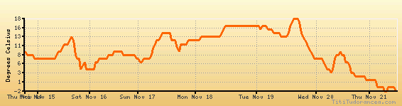
Temperature variation graph for the last seven days
Humidity Variation Graph

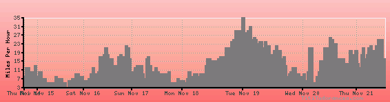
Wind speed
Weather Station: Bloomington/Normal, Central Illinois Regional Airport at Bloomington-Normal (latitude 40-28-37N, longitude 088-54-57W)
Local Time:
Bloomington/Normal is in the "America/Chicago" timezone.
The "America/Chicago" timezone uses a Standard Time (ST) / Daylight Saving Time (DST) alternation scheme, and it currently is in ST (since Sunday, 3 November 2024, 01:00 AM local time). During ST, the timezone abbreviation is CST and the offset to Universal Time (UTC, GMT or Zulu) is -6:00 hours.
Bloomington/Normal will exit standard time (entering DST) on Sunday, 9 March 2025, at 02:00 AM local time, when clocks will be turned forward 1 hour to Sunday, 9 March 2025, 03:00 AM local daylight time. During DST, the timezone abbreviation is CDT and the offset to UTC will be -5:00 hours.
Weather and Temperature in Illinois
Popular Weather Searches:
 If you own or manage a travel-related business such as a hotel, a bed-and-breakfast, a restaurant, a pub or a cafeteria, you can create a web page for your business for free on Titi Tudorancea Travel Info. » |