| Published in Weather / Norway Weather Temperature |
Weather in Batsfjord, Norway
Current Conditions (Thursday, March 13, 2025 at 17:50 UTC)
Temperature: 16°F (-9°C) |
Forecast Overview
Fri Mar 14 
23°F 16°F -5°C -9°C Chance of light snow in the morning.
detailsSat Mar 15 
23°F 14°F -5°C -10°C Chance of light snow late at night.
detailsSun Mar 16 30°F 23°F -1°C -5°C Chance of snow all night and day.
detailsMon Mar 17 32°F 27°F -0°C -3°C Chance of snow most of the day.
detailsTue Mar 18 
39°F 27°F 4°C -3°C Chance of rain in the afternoon. Chance of snow in the morning.
detailsWed Mar 19 
39°F 36°F 4°C 2°C Chance of light rain in the afternoon.
detailsThu Mar 20 
39°F 32°F 4°C -0°C Chance of rain after 6 pm. Chance of snow before sunrise and in the afternoon.
detailsFri Mar 21 36°F 32°F 2°C 0°C Chance of rain in the morning and late at night. Chance of snow at various times.
detailsSat Mar 22 
37°F 34°F 3°C 1°C Chance of snow after 6 pm.
details
Detailed Forecast
| Thursday, March 13 | sunrise: 04:40 sunset: 15:43 |
| Chance of snow in the evening and during the night (after 6 pm). Estimated precipitation: 0.1 in (2.4375 mm). Overcast skies. Wind: 26 mph (41 km/h). |
| Time | Skies | Conditions | Temp | Wind | Humidity | Soil Moisture |
| 18:00 21:00 | Chance of snow. Precipitation: 0.07 in (1.875 mm). | 25°F (-4°C) | 26 mph (41 km/h) | 82% | N/A | |
| 21:00 00:00 | Chance of light snow. Precipitation: 0.02 in (0.5625 mm). | 23°F (-5°C) | 25 mph (41 km/h) | 70% | N/A |
| Friday, March 14 | sunrise: 04:35 sunset: 15:47 |
| Low around 15°F (-9°C), high around 23°F (-5°C). Chance of light snow in the morning (before 3 am and from 6 am to 12 pm). Estimated precipitation: 0.05 in (1.1875 mm). Mostly cloudy skies. Wind: 26 mph (42 km/h). |
| Time | Skies | Conditions | Temp | Wind | Humidity | Soil Moisture |
| 00:00 03:00 | Chance of light snow. Precipitation: 0.01 in (0.25 mm). | 21°F (-6°C) | 26 mph (42 km/h) | 77% | N/A | |
| 03:00 06:00 | Overcast. Precipitation: 0 in (0.125 mm). | 20°F (-6°C) | 23 mph (38 km/h) | 65% | N/A | |
| 06:00 09:00 | Chance of light snow. Precipitation: 0 in (0.125 mm). | 20°F (-7°C) | 22 mph (35 km/h) | 65% | N/A | |
| 09:00 12:00 | Chance of light snow. Precipitation: 0 in (0.125 mm). | 21°F (-6°C) | 20 mph (32 km/h) | 54% | N/A | |
| 12:00 15:00 | Overcast. Precipitation: 0.01 in (0.1875 mm). | 21°F (-6°C) | 14 mph (23 km/h) | 48% | N/A | |
| 15:00 18:00 | Mostly cloudy. Precipitation: 0.01 in (0.25 mm). | 18°F (-8°C) | 10 mph (16 km/h) | 52% | N/A | |
| 18:00 21:00 | Clear. Precipitation: 0 in (0.125 mm). | 16°F (-9°C) | 15 mph (24 km/h) | 57% | N/A | |
| 21:00 00:00 | A few passing clouds. | 15°F (-9°C) | 17 mph (27 km/h) | 68% | N/A |
| Saturday, March 15 | sunrise: 04:30 sunset: 15:52 |
| Low around 14°F (-10°C), high around 23°F (-5°C). Chance of light snow late at night (after 9 pm). Estimated precipitation: 0.01 in (0.1875 mm). Partly cloudy skies. Wind: 16 mph (26 km/h). |
| Time | Skies | Conditions | Temp | Wind | Humidity | Soil Moisture |
| 00:00 03:00 | Clear. | 15°F (-9°C) | 14 mph (22 km/h) | 74% | N/A | |
| 03:00 06:00 | Mostly sunny. | 14°F (-10°C) | 13 mph (21 km/h) | 77% | N/A | |
| 06:00 09:00 | Mostly cloudy. | 17°F (-8°C) | 10 mph (17 km/h) | 69% | N/A | |
| 09:00 12:00 | Sunny. | 18°F (-8°C) | 9 mph (15 km/h) | 64% | N/A | |
| 12:00 15:00 | Partly cloudy. | 17°F (-8°C) | 13 mph (21 km/h) | 67% | N/A | |
| 15:00 18:00 | Overcast. | 15°F (-9°C) | 4 mph (7 km/h) | 66% | N/A | |
| 18:00 21:00 | Mostly cloudy. | 16°F (-9°C) | 9 mph (15 km/h) | 74% | N/A | |
| 21:00 00:00 | Chance of light snow. Precipitation: 0.01 in (0.1875 mm). | 23°F (-5°C) | 16 mph (26 km/h) | 69% | N/A |
| Sunday, March 16 | sunrise: 04:26 sunset: 15:56 |
| Low around 23°F (-5°C), high around 30°F (-1°C). Chance of snow all night and day. The precipitation may fall as scattered showers of varying intensity. Estimated precipitation: 0.27 in (6.875 mm). Overcast skies. Wind: 39 mph (63 km/h). |
| Time | Skies | Conditions | Temp | Wind | Humidity | Soil Moisture |
| 00:00 03:00 | Chance of light snow. Precipitation: 0.01 in (0.3125 mm). | 27°F (-3°C) | 30 mph (48 km/h) | 76% | N/A | |
| 03:00 06:00 | Chance of scattered snow showers. Precipitation: 0.05 in (1.3125 mm). | 28°F (-2°C) | 32 mph (52 km/h) | 64% | N/A | |
| 06:00 09:00 | Chance of scattered snow showers. Precipitation: 0.05 in (1.25 mm). | 27°F (-3°C) | 34 mph (55 km/h) | 78% | N/A | |
| 09:00 12:00 | Chance of scattered snow showers. Precipitation: 0.05 in (1.375 mm). | 26°F (-3°C) | 38 mph (60 km/h) | 82% | N/A | |
| 12:00 15:00 | Chance of scattered snow showers. Precipitation: 0.06 in (1.4375 mm). | 26°F (-3°C) | 39 mph (63 km/h) | 82% | N/A | |
| 15:00 18:00 | Chance of light snow. Precipitation: 0.02 in (0.5625 mm). | 26°F (-3°C) | 38 mph (62 km/h) | 78% | N/A | |
| 18:00 21:00 | Chance of light snow. Precipitation: 0.01 in (0.3125 mm). | 25°F (-4°C) | 36 mph (58 km/h) | 77% | N/A | |
| 21:00 00:00 | Chance of light snow. Precipitation: 0.01 in (0.3125 mm). | 26°F (-3°C) | 33 mph (53 km/h) | 74% | N/A |
| Monday, March 17 | sunrise: 04:21 sunset: 16:00 |
| Low around 26°F (-3°C), high around 31°F (-0°C). Chance of snow in the morning and early in the afternoon (before 3 am and from 6 am to 3 pm) and again in the evening (from 6 pm to 9 pm). Estimated precipitation: 0.25 in (6.375 mm). Overcast skies. Wind: 30 mph (48 km/h). |
| Time | Skies | Conditions | Temp | Wind | Humidity | Soil Moisture |
| 00:00 03:00 | Chance of light snow. Precipitation: 0.01 in (0.25 mm). | 27°F (-3°C) | 30 mph (48 km/h) | 66% | N/A | |
| 03:00 06:00 | Overcast. Precipitation: 0 in (0.125 mm). | 29°F (-2°C) | 26 mph (42 km/h) | 59% | N/A | |
| 06:00 09:00 | Chance of light snow. Precipitation: 0.03 in (0.6875 mm). | 28°F (-2°C) | 16 mph (26 km/h) | 87% | N/A | |
| 09:00 12:00 | Chance of snow. Precipitation: 0.05 in (1.375 mm). | 30°F (-1°C) | 15 mph (24 km/h) | 86% | N/A | |
| 12:00 15:00 | Chance of snow. Precipitation: 0.06 in (1.4375 mm). | 30°F (-1°C) | 12 mph (19 km/h) | 94% | N/A | |
| 15:00 18:00 | Overcast. Precipitation: 0.06 in (1.5625 mm). | 31°F (-1°C) | 13 mph (21 km/h) | 87% | N/A | |
| 18:00 21:00 | Chance of light snow. Precipitation: 0.03 in (0.6875 mm). | 29°F (-1°C) | 20 mph (32 km/h) | 75% | N/A | |
| 21:00 00:00 | Overcast. Precipitation: 0.01 in (0.25 mm). | 29°F (-2°C) | 19 mph (30 km/h) | 60% | N/A |
| Tuesday, March 18 | sunrise: 04:16 sunset: 16:04 |
| Low around 26°F (-3°C), high around 39°F (4°C). Chance of rain late in the afternoon (between 3 pm and 6 pm). Chance of snow early in the morning, between 3 am and 9 am. Estimated precipitation: 0.1 in (2.625 mm). Overcast skies. Wind: 32 mph (52 km/h). |
| Time | Skies | Conditions | Temp | Wind | Humidity | Soil Moisture |
| 00:00 03:00 | Overcast. | 29°F (-2°C) | 15 mph (23 km/h) | 64% | N/A | |
| 03:00 06:00 | Chance of light snow. Precipitation: 0 in (0.125 mm). | 27°F (-3°C) | 8 mph (13 km/h) | 75% | N/A | |
| 06:00 09:00 | Chance of light snow. Precipitation: 0.01 in (0.3125 mm). | 27°F (-3°C) | 8 mph (12 km/h) | 87% | N/A | |
| 09:00 12:00 | Mostly cloudy. Precipitation: 0 in (0.0625 mm). | 29°F (-2°C) | 8 mph (13 km/h) | 80% | N/A | |
| 12:00 15:00 | Overcast. | 30°F (-1°C) | 13 mph (21 km/h) | 87% | N/A | |
| 15:00 18:00 | Chance of rain. Precipitation: 0.08 in (1.9375 mm). | 38°F (3°C) | 28 mph (46 km/h) | 97% | N/A | |
| 18:00 21:00 | Overcast. Precipitation: 0 in (0.125 mm). | 37°F (3°C) | 31 mph (51 km/h) | 96% | N/A | |
| 21:00 00:00 | Overcast. Precipitation: 0 in (0.0625 mm). | 39°F (4°C) | 32 mph (52 km/h) | 85% | N/A |
| Wednesday, March 19 | sunrise: 04:11 sunset: 16:09 |
| Low around 35°F (2°C), high around 39°F (4°C). Chance of light rain early in the afternoon (between 12 pm and 3 pm). Estimated precipitation: 0.05 in (1.25 mm). Overcast skies. Wind: 36 mph (58 km/h). |
| Time | Skies | Conditions | Temp | Wind | Humidity | Soil Moisture |
| 00:00 03:00 | Overcast. Precipitation: 0.01 in (0.3125 mm). | 37°F (3°C) | 33 mph (52 km/h) | 96% | N/A | |
| 03:00 06:00 | Overcast. Precipitation: 0 in (0.125 mm). | 37°F (3°C) | 36 mph (58 km/h) | 96% | N/A | |
| 06:00 09:00 | Overcast. Precipitation: 0 in (0.0625 mm). | 37°F (3°C) | 33 mph (54 km/h) | 91% | N/A | |
| 09:00 12:00 | Overcast. | 39°F (4°C) | 35 mph (56 km/h) | 75% | N/A | |
| 12:00 15:00 | Chance of light rain. Precipitation: 0.02 in (0.5625 mm). | 37°F (3°C) | 34 mph (54 km/h) | 96% | N/A | |
| 15:00 18:00 | Overcast. Precipitation: 0.01 in (0.1875 mm). | 37°F (3°C) | 32 mph (51 km/h) | 82% | N/A | |
| 18:00 21:00 | Overcast. | 35°F (2°C) | 27 mph (43 km/h) | 82% | N/A | |
| 21:00 00:00 | Overcast. | 35°F (2°C) | 20 mph (32 km/h) | 80% | N/A |
| Thursday, March 20 | sunrise: 04:07 sunset: 16:13 |
| Low around 31°F (-0°C), high around 39°F (4°C). Chance of rain in the evening (between 6 pm and 9 pm). Chance of snow before sunrise (from midnight to 6 am) and late in the afternoon (from 3 pm to 6 pm). Estimated precipitation: 0.1 in (2.625 mm). Overcast skies. Wind: 29 mph (47 km/h). |
| Time | Skies | Conditions | Temp | Wind | Humidity | Soil Moisture |
| 00:00 03:00 | Chance of light snow. Precipitation: 0.01 in (0.375 mm). | 33°F (1°C) | 13 mph (21 km/h) | 88% | N/A | |
| 03:00 06:00 | Chance of light snow. Precipitation: 0.02 in (0.5 mm). | 35°F (2°C) | 18 mph (29 km/h) | 74% | N/A | |
| 06:00 09:00 | Overcast. Precipitation: 0 in (0.0625 mm). | 35°F (2°C) | 19 mph (30 km/h) | 64% | N/A | |
| 09:00 12:00 | Overcast. | 34°F (1°C) | 11 mph (18 km/h) | 69% | N/A | |
| 12:00 15:00 | Overcast. | 33°F (1°C) | 12 mph (19 km/h) | 78% | N/A | |
| 15:00 18:00 | Chance of snow. Precipitation: 0.05 in (1.1875 mm). | 36°F (2°C) | 23 mph (38 km/h) | 90% | N/A | |
| 18:00 21:00 | Chance of light rain. Precipitation: 0.01 in (0.375 mm). | 38°F (4°C) | 29 mph (47 km/h) | 96% | N/A | |
| 21:00 00:00 | Overcast. Precipitation: 0 in (0.125 mm). | 35°F (2°C) | 18 mph (30 km/h) | 85% | N/A |
| Friday, March 21 | sunrise: 04:02 sunset: 16:17 |
| Low around 33°F (0°C), high around 36°F (2°C). Chance of rain in the morning (between 9 am and 12 pm) and at night (after 9 pm). Chance of snow early in the morning (until 9 am) and during late afternoon and evening (between 3 pm and 9 pm). Estimated precipitation: 0.2 in (5.1875 mm). Overcast skies. Wind: 8 mph (13 km/h). |
| Time | Skies | Conditions | Temp | Wind | Humidity | Soil Moisture |
| 00:00 03:00 | Chance of light snow. Precipitation: 0.01 in (0.375 mm). | 34°F (1°C) | 8 mph (13 km/h) | 99% | N/A | |
| 03:00 06:00 | Chance of light snow. Precipitation: 0.01 in (0.375 mm). | 33°F (0°C) | 3 mph (5 km/h) | 98% | N/A | |
| 06:00 09:00 | Chance of snow. Precipitation: 0.05 in (1.375 mm). | 35°F (2°C) | 6 mph (10 km/h) | 99% | N/A | |
| 09:00 12:00 | Chance of rain. Precipitation: 0.04 in (1.125 mm). | 36°F (2°C) | 5 mph (8 km/h) | 99% | N/A | |
| 12:00 15:00 | Overcast. Precipitation: 0.01 in (0.25 mm). | 36°F (2°C) | 2 mph (3 km/h) | 98% | N/A | |
| 15:00 18:00 | Chance of light snow. Precipitation: 0.01 in (0.1875 mm). | 36°F (2°C) | 6 mph (10 km/h) | 98% | N/A | |
| 18:00 21:00 | Chance of light snow. Precipitation: 0.03 in (0.6875 mm). | 36°F (2°C) | 8 mph (12 km/h) | 98% | N/A | |
| 21:00 00:00 | Chance of light rain. Precipitation: 0.03 in (0.8125 mm). | 36°F (2°C) | 5 mph (8 km/h) | 98% | N/A |
| Saturday, March 22 | sunrise: 03:57 sunset: 16:21 |
| Low around 34°F (1°C), high around 38°F (3°C). Chance of snow in the evening and during the night (after 6 pm). Estimated precipitation: 0.09 in (2.3125 mm). Overcast skies. Wind: 36 mph (57 km/h). |
| Time | Skies | Conditions | Temp | Wind | Humidity | Soil Moisture |
| 00:00 03:00 | Overcast. Precipitation: 0 in (0.125 mm). | 37°F (3°C) | 7 mph (12 km/h) | 95% | N/A | |
| 03:00 06:00 | More sun than clouds. | 37°F (3°C) | 11 mph (18 km/h) | 90% | N/A | |
| 06:00 09:00 | Sunny. | 37°F (3°C) | 14 mph (23 km/h) | 86% | N/A | |
| 09:00 12:00 | Overcast. | 37°F (3°C) | 24 mph (38 km/h) | 82% | N/A | |
| 12:00 15:00 | Overcast. Precipitation: 0 in (0.0625 mm). | 37°F (3°C) | 36 mph (57 km/h) | 83% | N/A | |
| 15:00 18:00 | Overcast. | 38°F (3°C) | 22 mph (35 km/h) | 83% | N/A | |
| 18:00 21:00 | Chance of snow. Precipitation: 0.04 in (1.0625 mm). | 35°F (2°C) | 9 mph (14 km/h) | 98% | N/A | |
| 21:00 00:00 | Chance of snow. Precipitation: 0.04 in (1.0625 mm). | 35°F (1°C) | 8 mph (12 km/h) | 93% | N/A |
Climate Chart
Places with a similar climate: Vadso, Mehamn.
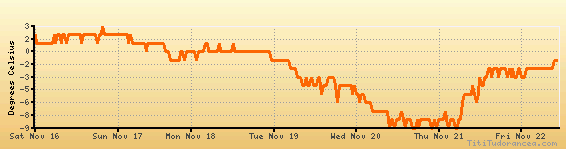
Temperature variation graph for the last seven days
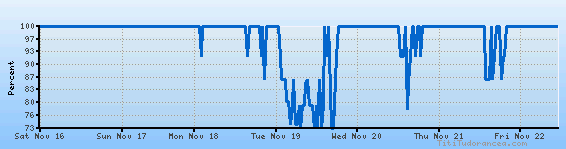
Humidity Variation Graph
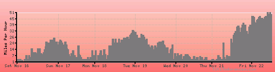
Wind speed
Weather Station: Batsfjord (latitude 70-38N, longitude 029-44E)
Weather and Temperature in Norway
Popular Weather Searches:
 If you own or manage a travel-related business such as a hotel, a bed-and-breakfast, a restaurant, a pub or a cafeteria, you can create a web page for your business for free on Titi Tudorancea Travel Info. » |