| Published in Weather / Wisconsin Weather Temperature |
Weather in Ashland, Wisconsin
Current Conditions (Sunday, February 2, 2025 at 08:08 America/Chicago time)
Temperature: 28°F (-2°C) |
Forecast Overview
Mon Feb 3 
36°F 19°F 2°C -7°C Chance of light snow before sunrise.
detailsTue Feb 4 19°F 5°F -7°C -15°C Chance of light snow before sunrise.
detailsWed Feb 5 
12°F 5°F -11°C -15°C Overcast skies.
detailsThu Feb 6 
19°F 9°F -7°C -13°C Chance of snow after 12 pm.
detailsFri Feb 7 18°F 7°F -8°C -14°C Chance of light snow at various times.
detailsSat Feb 8 
19°F 3°F -7°C -16°C Considerable cloudiness.
detailsSun Feb 9 25°F 9°F -4°C -13°C Mostly cloudy skies.
detailsMon Feb 10 
23°F 5°F -5°C -15°C Times of sun and clouds.
detailsTue Feb 11 
19°F 9°F -7°C -13°C Chance of light snow in the morning and in the afternoon.
details
Detailed Forecast
| Monday, February 3 | sunrise: 07:26 sunset: 17:09 |
| Low around 19°F (-7°C), high around 35°F (2°C). Chance of light snow between midnight and 3 am. Estimated precipitation: 0.06 in (1.5 mm). Overcast skies. Wind: 10 mph (16 km/h). |
| Time | Skies | Conditions | Temp | Wind | Humidity | Soil Moisture |
| 00:00 03:00 | Chance of light snow. Precipitation: 0.02 in (0.4375 mm). | 23°F (-5°C) | 8 mph (13 km/h) | 94% | 0.433% | |
| 03:00 06:00 | Overcast. Precipitation: 0.03 in (0.875 mm). | 25°F (-4°C) | 8 mph (12 km/h) | 93% | 0.433% | |
| 06:00 09:00 | Overcast. Precipitation: 0.01 in (0.1875 mm). | 28°F (-2°C) | 8 mph (12 km/h) | 90% | 0.432% | |
| 09:00 12:00 | Overcast. | 34°F (1°C) | 9 mph (14 km/h) | 89% | 0.434% | |
| 12:00 15:00 | More sun than clouds. | 35°F (2°C) | 10 mph (16 km/h) | 83% | 0.438% | |
| 15:00 18:00 | Overcast. | 28°F (-2°C) | 8 mph (13 km/h) | 82% | 0.438% | |
| 18:00 21:00 | Overcast. | 22°F (-6°C) | 7 mph (11 km/h) | 79% | 0.438% | |
| 21:00 00:00 | Overcast. | 19°F (-7°C) | 6 mph (10 km/h) | 82% | 0.437% |
| Tuesday, February 4 | sunrise: 07:25 sunset: 17:10 |
| Low around 6°F (-15°C), high around 19°F (-7°C). Chance of light snow between midnight and 3 am. Estimated precipitation: 0.04 in (1 mm). Overcast skies. Wind: 11 mph (17 km/h). |
| Time | Skies | Conditions | Temp | Wind | Humidity | Soil Moisture |
| 00:00 03:00 | Chance of light snow. Precipitation: 0.01 in (0.3125 mm). | 17°F (-8°C) | 6 mph (10 km/h) | 87% | 0.437% | |
| 03:00 06:00 | Overcast. Precipitation: 0.02 in (0.4375 mm). | 16°F (-9°C) | 4 mph (6 km/h) | 86% | 0.437% | |
| 06:00 09:00 | Overcast. Precipitation: 0.01 in (0.1875 mm). | 16°F (-9°C) | 6 mph (10 km/h) | 79% | 0.437% | |
| 09:00 12:00 | Overcast. | 18°F (-8°C) | 7 mph (12 km/h) | 64% | 0.436% | |
| 12:00 15:00 | Overcast. | 18°F (-8°C) | 9 mph (15 km/h) | 65% | 0.436% | |
| 15:00 18:00 | Overcast. | 15°F (-10°C) | 10 mph (15 km/h) | 75% | 0.435% | |
| 18:00 21:00 | Overcast. Precipitation: 0 in (0.0625 mm). | 10°F (-12°C) | 11 mph (17 km/h) | 78% | 0.435% | |
| 21:00 00:00 | Overcast. | 6°F (-15°C) | 9 mph (14 km/h) | 81% | 0.435% |
| Wednesday, February 5 | sunrise: 07:23 sunset: 17:12 |
| Low around 5°F (-15°C), high around 13°F (-11°C). Overcast skies. Wind: 7 mph (11 km/h). |
| Time | Skies | Conditions | Temp | Wind | Humidity | Soil Moisture |
| 00:00 03:00 | Overcast. | 5°F (-15°C) | 7 mph (11 km/h) | 85% | 0.435% | |
| 03:00 06:00 | Overcast. | 5°F (-15°C) | 4 mph (7 km/h) | 89% | 0.435% | |
| 06:00 09:00 | Overcast. | 7°F (-14°C) | 6 mph (9 km/h) | 81% | 0.436% | |
| 09:00 12:00 | Overcast. | 11°F (-11°C) | 6 mph (9 km/h) | 69% | 0.436% | |
| 12:00 15:00 | Overcast. | 13°F (-11°C) | 6 mph (9 km/h) | 67% | 0.435% | |
| 15:00 18:00 | Overcast. | 10°F (-12°C) | 2 mph (4 km/h) | 83% | 0.435% | |
| 18:00 21:00 | Overcast. | 11°F (-11°C) | 3 mph (5 km/h) | 80% | 0.435% | |
| 21:00 00:00 | Overcast. | 12°F (-11°C) | 3 mph (5 km/h) | 85% | 0.435% |
| Thursday, February 6 | sunrise: 07:22 sunset: 17:13 |
| Low around 9°F (-13°C), high around 19°F (-7°C). Chance of snow from 12 pm till midnight. Estimated precipitation: 0.11 in (2.6875 mm). Overcast skies. Wind: 4 mph (6 km/h). |
| Time | Skies | Conditions | Temp | Wind | Humidity | Soil Moisture |
| 00:00 03:00 | Overcast. | 11°F (-12°C) | 2 mph (3 km/h) | 91% | 0.435% | |
| 03:00 06:00 | Overcast. | 10°F (-12°C) | 2 mph (3 km/h) | 90% | 0.435% | |
| 06:00 09:00 | Overcast. | 12°F (-11°C) | 1 mph (1 km/h) | 80% | 0.435% | |
| 09:00 12:00 | Overcast. | 17°F (-8°C) | 2 mph (3 km/h) | 72% | 0.435% | |
| 12:00 15:00 | Chance of light snow. Precipitation: 0.01 in (0.375 mm). | 19°F (-7°C) | 2 mph (4 km/h) | 89% | 0.434% | |
| 15:00 18:00 | Chance of light snow. Precipitation: 0.03 in (0.6875 mm). | 16°F (-9°C) | 4 mph (6 km/h) | 96% | 0.434% | |
| 18:00 21:00 | Chance of snow. Precipitation: 0.05 in (1.3125 mm). | 16°F (-9°C) | 2 mph (2 km/h) | 96% | 0.434% | |
| 21:00 00:00 | Chance of light snow. Precipitation: 0.01 in (0.3125 mm). | 16°F (-9°C) | 2 mph (3 km/h) | 96% | 0.434% |
| Friday, February 7 | sunrise: 07:21 sunset: 17:15 |
| Low around 7°F (-14°C), high around 17°F (-8°C). Chance of light snow early in the morning (until 9 am) and early in the afternoon (between 12 pm and 3 pm). Estimated precipitation: 0.04 in (1.125 mm). Mostly cloudy skies. Wind: 13 mph (22 km/h). |
| Time | Skies | Conditions | Temp | Wind | Humidity | Soil Moisture |
| 00:00 03:00 | Chance of light snow. Precipitation: 0 in (0.0625 mm). | 14°F (-10°C) | 4 mph (6 km/h) | 97% | 0.434% | |
| 03:00 06:00 | Chance of light snow. Precipitation: 0.02 in (0.5 mm). | 16°F (-9°C) | 7 mph (11 km/h) | 94% | 0.433% | |
| 06:00 09:00 | Chance of light snow. Precipitation: 0.01 in (0.375 mm). | 15°F (-9°C) | 11 mph (17 km/h) | 86% | 0.433% | |
| 09:00 12:00 | Overcast. Precipitation: 0 in (0.125 mm). | 15°F (-9°C) | 13 mph (22 km/h) | 72% | 0.433% | |
| 12:00 15:00 | Chance of light snow. Precipitation: 0 in (0.0625 mm). | 16°F (-9°C) | 13 mph (20 km/h) | 75% | 0.433% | |
| 15:00 18:00 | Clear. | 12°F (-11°C) | 12 mph (19 km/h) | 76% | 0.433% | |
| 18:00 21:00 | Overcast. | 9°F (-13°C) | 11 mph (18 km/h) | 80% | 0.432% | |
| 21:00 00:00 | Overcast. | 7°F (-14°C) | 9 mph (15 km/h) | 87% | 0.432% |
| Saturday, February 8 | sunrise: 07:19 sunset: 17:16 |
| Low around 3°F (-16°C), high around 20°F (-7°C). Considerable cloudiness. Wind: 9 mph (14 km/h). |
| Time | Skies | Conditions | Temp | Wind | Humidity | Soil Moisture |
| 00:00 03:00 | Mostly cloudy. | 5°F (-15°C) | 8 mph (13 km/h) | 90% | 0.432% | |
| 03:00 06:00 | Clear. | 4°F (-16°C) | 8 mph (13 km/h) | 90% | 0.432% | |
| 06:00 09:00 | Mostly sunny. | 6°F (-14°C) | 9 mph (14 km/h) | 84% | 0.432% | |
| 09:00 12:00 | Overcast. | 16°F (-9°C) | 6 mph (9 km/h) | 72% | 0.432% | |
| 12:00 15:00 | Overcast. | 20°F (-7°C) | 6 mph (9 km/h) | 68% | 0.432% | |
| 15:00 18:00 | Times of clear skies and clouds. | 11°F (-12°C) | 2 mph (2 km/h) | 92% | 0.432% | |
| 18:00 21:00 | Overcast. | 10°F (-12°C) | 4 mph (6 km/h) | 94% | 0.432% | |
| 21:00 00:00 | Overcast. | 13°F (-11°C) | 4 mph (6 km/h) | 93% | 0.432% |
| Sunday, February 9 | sunrise: 07:18 sunset: 17:18 |
| Low around 9°F (-13°C), high around 24°F (-4°C). Mostly cloudy skies. Wind: 5 mph (8 km/h). |
| Time | Skies | Conditions | Temp | Wind | Humidity | Soil Moisture |
| 00:00 03:00 | Overcast. | 13°F (-11°C) | 4 mph (6 km/h) | 92% | 0.432% | |
| 03:00 06:00 | Overcast. | 14°F (-10°C) | 3 mph (5 km/h) | 91% | 0.431% | |
| 06:00 09:00 | Overcast. | 17°F (-8°C) | 4 mph (6 km/h) | 83% | 0.431% | |
| 09:00 12:00 | Overcast. | 23°F (-5°C) | 3 mph (5 km/h) | 73% | 0.431% | |
| 12:00 15:00 | Overcast. | 24°F (-4°C) | 4 mph (7 km/h) | 72% | 0.431% | |
| 15:00 18:00 | Overcast. | 14°F (-10°C) | 4 mph (6 km/h) | 94% | 0.43% | |
| 18:00 21:00 | Mostly cloudy. | 14°F (-10°C) | 5 mph (8 km/h) | 92% | 0.43% | |
| 21:00 00:00 | Clear. | 10°F (-12°C) | 4 mph (7 km/h) | 96% | 0.43% |
| Monday, February 10 | sunrise: 07:17 sunset: 17:19 |
| Low around 6°F (-15°C), high around 23°F (-5°C). Times of sun and clouds. Wind: 6 mph (10 km/h). |
| Time | Skies | Conditions | Temp | Wind | Humidity | Soil Moisture |
| 00:00 03:00 | A few passing clouds. | 8°F (-13°C) | 5 mph (8 km/h) | 96% | 0.43% | |
| 03:00 06:00 | Clear. | 7°F (-14°C) | 6 mph (9 km/h) | 96% | 0.43% | |
| 06:00 09:00 | Sunny. | 10°F (-12°C) | 6 mph (10 km/h) | 86% | 0.43% | |
| 09:00 12:00 | Sunny. | 19°F (-7°C) | 5 mph (7 km/h) | 65% | 0.43% | |
| 12:00 15:00 | Sunny. | 23°F (-5°C) | 6 mph (9 km/h) | 58% | 0.429% | |
| 15:00 18:00 | Partly cloudy. | 12°F (-11°C) | 4 mph (7 km/h) | 90% | 0.429% | |
| 18:00 21:00 | Overcast. | 12°F (-11°C) | 6 mph (10 km/h) | 93% | 0.429% | |
| 21:00 00:00 | Overcast. | 10°F (-12°C) | 6 mph (9 km/h) | 94% | 0.429% |
| Tuesday, February 11 | sunrise: 07:15 sunset: 17:21 |
| Low around 9°F (-13°C), high around 20°F (-7°C). Chance of light snow early in the morning (between 6 am and 9 am) and again in the afternoon (between 12 pm and 6 pm). Estimated precipitation: 0.01 in (0.375 mm). Mostly cloudy skies. Wind: 9 mph (15 km/h). |
| Time | Skies | Conditions | Temp | Wind | Humidity | Soil Moisture |
| 00:00 03:00 | Overcast. | 9°F (-13°C) | 5 mph (8 km/h) | 94% | 0.429% | |
| 03:00 06:00 | Overcast. | 10°F (-12°C) | 6 mph (9 km/h) | 91% | 0.429% | |
| 06:00 09:00 | Chance of light snow. Precipitation: 0 in (0.0625 mm). | 14°F (-10°C) | 7 mph (12 km/h) | 87% | 0.429% | |
| 09:00 12:00 | Overcast. Precipitation: 0 in (0.0625 mm). | 19°F (-7°C) | 8 mph (13 km/h) | 75% | 0.428% | |
| 12:00 15:00 | Chance of light snow. Precipitation: 0 in (0.125 mm). | 19°F (-7°C) | 9 mph (15 km/h) | 75% | 0.428% | |
| 15:00 18:00 | Chance of light snow. Precipitation: 0 in (0.0625 mm). | 16°F (-9°C) | 7 mph (11 km/h) | 91% | 0.428% | |
| 18:00 21:00 | Overcast. Precipitation: 0 in (0.0625 mm). | 14°F (-10°C) | 8 mph (13 km/h) | 85% | 0.428% | |
| 21:00 00:00 | Clear. | 10°F (-12°C) | 7 mph (12 km/h) | 91% | 0.428% |
Climate Chart
Places with a similar climate: Superior (WI), Rhinelander, Oneida County (WI), Ironwood, Gogebic County (MI), Antigo, Langlade County (WI), Iron Mountain / Kingsford (MI), Eagle River (WI), Mc Gregor (MN), Moose Lake, Carlton County (MN), Mora (MN), Merrill (WI), Tomahawk (WI), Minocqua/Woodruff (WI), Marquette (MI), Aitkin (MN), Little Falls, Morrison County (MN), Eveleth (MN), Hayward (WI), Ladysmith, Ruck County (WI), Land O' Lakes (WI), Grand Rapids, Itasca County (MN), Escanaba (MI), Pellston, Emmet County (MI), Duluth (MN), Two Harbors (MN), Phillips, Price County (WI).
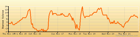
Temperature variation graph for the last seven days
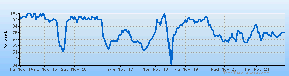
Humidity Variation Graph
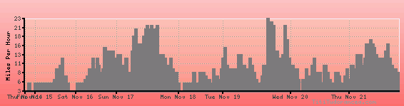
Wind speed
Weather Station: Ashland, Kennedy Memorial Airport (latitude 46-32-59N, longitude 090-55-06W)
Local Time:
Ashland is in the "America/Chicago" timezone.
The "America/Chicago" timezone uses a Standard Time (ST) / Daylight Saving Time (DST) alternation scheme, and it currently is in ST (since Sunday, 3 November 2024, 01:00 AM local time). During ST, the timezone abbreviation is CST and the offset to Universal Time (UTC, GMT or Zulu) is -6:00 hours.
Ashland will exit standard time (entering DST) on Sunday, 9 March 2025, at 02:00 AM local time, when clocks will be turned forward 1 hour to Sunday, 9 March 2025, 03:00 AM local daylight time. During DST, the timezone abbreviation is CDT and the offset to UTC will be -5:00 hours.
Weather and Temperature in Wisconsin
Popular Weather Searches:
 If you own or manage a travel-related business such as a hotel, a bed-and-breakfast, a restaurant, a pub or a cafeteria, you can create a web page for your business for free on Titi Tudorancea Travel Info. » |