| Published in Weather / Spain Weather Temperature |
Weather in Alicante / El Altet, Spain
Current Conditions (Saturday, February 1, 2025 at 05:30 Europe/Madrid time)
Temperature: 48°F (9°C) |
Forecast Overview
Sat Feb 1 
61°F 48°F 16°C 9°C Chance of light rain in the afternoon.
detailsSun Feb 2 
57°F 48°F 14°C 9°C Considerable cloudiness.
detailsMon Feb 3 
57°F 52°F 14°C 11°C Chance of light rain before sunrise and late at night.
detailsTue Feb 4 
59°F 50°F 15°C 10°C Chance of light rain before sunrise.
detailsWed Feb 5 
59°F 50°F 15°C 10°C A few passing clouds.
detailsThu Feb 6 
57°F 50°F 14°C 10°C Overcast skies.
detailsFri Feb 7 
57°F 50°F 14°C 10°C Chance of light rain before sunrise.
detailsSat Feb 8 57°F 50°F 14°C 10°C A few passing clouds.
detailsSun Feb 9 
61°F 50°F 16°C 10°C Chance of light rain after 7 pm.
details
Detailed Forecast
| Saturday, February 1 | sunrise: 08:08 sunset: 18:23 |
| Low around 48°F (9°C), high around 61°F (16°C). Chance of light rain late in the afternoon (between 4 pm and 7 pm). Estimated precipitation: 0.04 in (0.9375 mm). More sun than clouds. Wind: 14 mph (22 km/h). |
| Time | Skies | Conditions | Temp | Wind | Humidity | Soil Moisture |
| 01:00 04:00 | Clear. | 50°F (10°C) | 8 mph (14 km/h) | 72% | N/A | |
| 04:00 07:00 | Overcast. | 48°F (9°C) | 13 mph (21 km/h) | 51% | N/A | |
| 07:00 10:00 | Sunny. | 51°F (11°C) | 11 mph (17 km/h) | 48% | N/A | |
| 10:00 13:00 | Mostly sunny. | 60°F (16°C) | 8 mph (13 km/h) | 38% | N/A | |
| 13:00 16:00 | Mostly cloudy. | 59°F (15°C) | 10 mph (16 km/h) | 48% | N/A | |
| 16:00 19:00 | Chance of light rain. Precipitation: 0.01 in (0.25 mm). | 55°F (13°C) | 14 mph (22 km/h) | 65% | N/A | |
| 19:00 22:00 | Clear. Precipitation: 0.01 in (0.1875 mm). | 50°F (10°C) | 2 mph (3 km/h) | 77% | N/A | |
| 22:00 01:00 | Mostly clear. Precipitation: 0.02 in (0.5 mm). | 50°F (10°C) | 11 mph (18 km/h) | 66% | N/A |
| Sunday, February 2 | sunrise: 08:07 sunset: 18:24 |
| Low around 48°F (9°C), high around 57°F (14°C). Estimated precipitation: 0.02 in (0.4375 mm). Considerable cloudiness. Wind: 11 mph (18 km/h). |
| Time | Skies | Conditions | Temp | Wind | Humidity | Soil Moisture |
| 01:00 04:00 | Overcast. Precipitation: 0 in (0.0625 mm). | 49°F (10°C) | 11 mph (18 km/h) | 71% | N/A | |
| 04:00 07:00 | Mostly cloudy. Precipitation: 0 in (0.0625 mm). | 51°F (11°C) | 11 mph (18 km/h) | 66% | N/A | |
| 07:00 10:00 | Sunny. | 53°F (11°C) | 8 mph (13 km/h) | 63% | N/A | |
| 10:00 13:00 | Sunny. | 56°F (13°C) | 5 mph (7 km/h) | 54% | N/A | |
| 13:00 16:00 | Sunny. | 55°F (13°C) | 11 mph (17 km/h) | 61% | N/A | |
| 16:00 19:00 | Overcast. | 54°F (12°C) | 5 mph (8 km/h) | 65% | N/A | |
| 19:00 22:00 | Overcast. Precipitation: 0 in (0.0625 mm). | 53°F (12°C) | 3 mph (5 km/h) | 68% | N/A | |
| 22:00 01:00 | Overcast. Precipitation: 0.01 in (0.25 mm). | 52°F (11°C) | 3 mph (5 km/h) | 70% | N/A |
| Monday, February 3 | sunrise: 08:06 sunset: 18:25 |
| Low around 52°F (11°C), high around 57°F (14°C). Chance of light rain before sunrise (from 1 am to 7 am) and again at night (after 10 pm). Estimated precipitation: 0.05 in (1.25 mm). More clouds than sun. Wind: 20 mph (31 km/h). |
| Time | Skies | Conditions | Temp | Wind | Humidity | Soil Moisture |
| 01:00 04:00 | Chance of light rain. Precipitation: 0.01 in (0.3125 mm). | 52°F (11°C) | 8 mph (13 km/h) | 72% | N/A | |
| 04:00 07:00 | Chance of light rain. Precipitation: 0.02 in (0.5625 mm). | 52°F (11°C) | 13 mph (22 km/h) | 75% | N/A | |
| 07:00 10:00 | Mostly sunny. Precipitation: 0.01 in (0.3125 mm). | 54°F (12°C) | 15 mph (24 km/h) | 65% | N/A | |
| 10:00 13:00 | Overcast. | 56°F (13°C) | 16 mph (26 km/h) | 59% | N/A | |
| 13:00 16:00 | Times of sun and clouds. | 56°F (14°C) | 20 mph (31 km/h) | 64% | N/A | |
| 16:00 19:00 | Mostly clear, with a few passing clouds. | 55°F (13°C) | 18 mph (29 km/h) | 71% | N/A | |
| 19:00 22:00 | A few passing clouds. | 53°F (12°C) | 13 mph (21 km/h) | 73% | N/A | |
| 22:00 01:00 | Chance of light rain. Precipitation: 0 in (0.0625 mm). | 53°F (11°C) | 9 mph (15 km/h) | 75% | N/A |
| Tuesday, February 4 | sunrise: 08:05 sunset: 18:26 |
| Low around 51°F (10°C), high around 58°F (15°C). Chance of light rain between 1 am and 4 am. Estimated precipitation: 0.02 in (0.625 mm). Mostly sunny. Wind: 9 mph (14 km/h). |
| Time | Skies | Conditions | Temp | Wind | Humidity | Soil Moisture |
| 01:00 04:00 | Chance of light rain. Precipitation: 0.01 in (0.3125 mm). | 54°F (12°C) | 9 mph (14 km/h) | 72% | N/A | |
| 04:00 07:00 | Clear. Precipitation: 0.01 in (0.3125 mm). | 53°F (12°C) | 6 mph (10 km/h) | 70% | N/A | |
| 07:00 10:00 | Sunny. | 53°F (12°C) | 4 mph (7 km/h) | 65% | N/A | |
| 10:00 13:00 | Sunny. | 57°F (14°C) | 6 mph (9 km/h) | 63% | N/A | |
| 13:00 16:00 | Sunny. | 57°F (14°C) | 8 mph (12 km/h) | 68% | N/A | |
| 16:00 19:00 | Clear. | 55°F (13°C) | 3 mph (5 km/h) | 76% | N/A | |
| 19:00 22:00 | Clear. | 53°F (12°C) | 2 mph (3 km/h) | 78% | N/A | |
| 22:00 01:00 | Clear. | 52°F (11°C) | 5 mph (8 km/h) | 80% | N/A |
| Wednesday, February 5 | sunrise: 08:05 sunset: 18:27 |
| Low around 50°F (10°C), high around 58°F (15°C). A few passing clouds. Wind: 8 mph (13 km/h). |
| Time | Skies | Conditions | Temp | Wind | Humidity | Soil Moisture |
| 01:00 04:00 | Clear. | 51°F (11°C) | 3 mph (5 km/h) | 78% | N/A | |
| 04:00 07:00 | Clear. | 51°F (10°C) | 1 mph (2 km/h) | 74% | N/A | |
| 07:00 10:00 | Sunny. | 55°F (13°C) | 3 mph (5 km/h) | 70% | N/A | |
| 10:00 13:00 | Mostly sunny. | 58°F (14°C) | 6 mph (9 km/h) | 61% | N/A | |
| 13:00 16:00 | Sunny. | 57°F (14°C) | 8 mph (13 km/h) | 62% | N/A | |
| 16:00 19:00 | Clear. | 55°F (13°C) | 6 mph (10 km/h) | 70% | N/A | |
| 19:00 22:00 | Overcast. | 53°F (12°C) | 1 mph (2 km/h) | 69% | N/A | |
| 22:00 01:00 | Overcast. | 52°F (11°C) | 3 mph (5 km/h) | 72% | N/A |
| Thursday, February 6 | sunrise: 08:04 sunset: 18:29 |
| Low around 50°F (10°C), high around 57°F (14°C). Estimated precipitation: 0.01 in (0.375 mm). Overcast skies. Wind: 5 mph (9 km/h). |
| Time | Skies | Conditions | Temp | Wind | Humidity | Soil Moisture |
| 01:00 04:00 | Overcast. | 51°F (11°C) | 5 mph (9 km/h) | 76% | N/A | |
| 04:00 07:00 | Overcast. | 51°F (10°C) | 5 mph (8 km/h) | 72% | N/A | |
| 07:00 10:00 | Overcast. | 53°F (12°C) | 5 mph (7 km/h) | 65% | N/A | |
| 10:00 13:00 | Overcast. | 56°F (14°C) | 3 mph (4 km/h) | 55% | N/A | |
| 13:00 16:00 | Overcast. | 56°F (13°C) | 5 mph (8 km/h) | 60% | N/A | |
| 16:00 19:00 | Overcast. | 54°F (12°C) | 4 mph (7 km/h) | 66% | N/A | |
| 19:00 22:00 | Overcast. | 53°F (12°C) | 4 mph (6 km/h) | 70% | N/A | |
| 22:00 01:00 | Overcast. Precipitation: 0.01 in (0.375 mm). | 52°F (11°C) | 5 mph (8 km/h) | 78% | N/A |
| Friday, February 7 | sunrise: 08:03 sunset: 18:30 |
| Low around 50°F (10°C), high around 58°F (14°C). Chance of light rain between 1 am and 4 am. Estimated precipitation: 0.03 in (0.75 mm). Times of sun and clouds. Wind: 10 mph (15 km/h). |
| Time | Skies | Conditions | Temp | Wind | Humidity | Soil Moisture |
| 01:00 04:00 | Chance of light rain. Precipitation: 0.01 in (0.3125 mm). | 53°F (11°C) | 4 mph (6 km/h) | 73% | N/A | |
| 04:00 07:00 | Clear. Precipitation: 0.02 in (0.4375 mm). | 51°F (10°C) | 3 mph (4 km/h) | 75% | N/A | |
| 07:00 10:00 | Sunny. | 53°F (12°C) | 5 mph (8 km/h) | 68% | N/A | |
| 10:00 13:00 | Sunny. | 57°F (14°C) | 2 mph (3 km/h) | 57% | N/A | |
| 13:00 16:00 | Sunny. | 56°F (14°C) | 8 mph (14 km/h) | 62% | N/A | |
| 16:00 19:00 | Clear. | 55°F (13°C) | 10 mph (15 km/h) | 76% | N/A | |
| 19:00 22:00 | Clear. | 54°F (12°C) | 7 mph (11 km/h) | 78% | N/A | |
| 22:00 01:00 | Overcast. | 52°F (11°C) | 4 mph (7 km/h) | 79% | N/A |
| Saturday, February 8 | sunrise: 08:02 sunset: 18:31 |
| Low around 50°F (10°C), high around 58°F (14°C). Estimated precipitation: 0.01 in (0.3125 mm). A few passing clouds. Wind: 10 mph (15 km/h). |
| Time | Skies | Conditions | Temp | Wind | Humidity | Soil Moisture |
| 01:00 04:00 | Overcast. | 51°F (11°C) | 3 mph (6 km/h) | 78% | N/A | |
| 04:00 07:00 | Times of clear skies and clouds. | 51°F (10°C) | 2 mph (3 km/h) | 75% | N/A | |
| 07:00 10:00 | Sunny. | 55°F (13°C) | 4 mph (7 km/h) | 68% | N/A | |
| 10:00 13:00 | More clouds than sun. Precipitation: 0 in (0.125 mm). | 57°F (14°C) | 10 mph (15 km/h) | 74% | N/A | |
| 13:00 16:00 | Sunny. Precipitation: 0 in (0.125 mm). | 57°F (14°C) | 9 mph (14 km/h) | 74% | N/A | |
| 16:00 19:00 | Clear. Precipitation: 0 in (0.0625 mm). | 55°F (13°C) | 8 mph (12 km/h) | 79% | N/A | |
| 19:00 22:00 | Clear. | 54°F (12°C) | 6 mph (10 km/h) | 80% | N/A | |
| 22:00 01:00 | Clear. | 52°F (11°C) | 3 mph (5 km/h) | 81% | N/A |
| Sunday, February 9 | sunrise: 08:01 sunset: 18:32 |
| Low around 50°F (10°C), high around 60°F (16°C). Chance of light rain in the evening (between 7 pm and 10 pm). Estimated precipitation: 0.02 in (0.4375 mm). More clouds than sun. Wind: 12 mph (20 km/h). |
| Time | Skies | Conditions | Temp | Wind | Humidity | Soil Moisture |
| 01:00 04:00 | Clear. | 52°F (11°C) | 4 mph (7 km/h) | 78% | N/A | |
| 04:00 07:00 | Clear. | 50°F (10°C) | 6 mph (9 km/h) | 74% | N/A | |
| 07:00 10:00 | Sunny. | 53°F (12°C) | 5 mph (8 km/h) | 63% | N/A | |
| 10:00 13:00 | Sunny. | 59°F (15°C) | 1 mph (1 km/h) | 48% | N/A | |
| 13:00 16:00 | Mostly sunny. | 58°F (15°C) | 8 mph (12 km/h) | 56% | N/A | |
| 16:00 19:00 | Overcast. | 56°F (14°C) | 8 mph (13 km/h) | 75% | N/A | |
| 19:00 22:00 | Chance of light rain. Precipitation: 0 in (0.0625 mm). | 55°F (13°C) | 12 mph (20 km/h) | 79% | N/A | |
| 22:00 01:00 | Overcast. Precipitation: 0.01 in (0.375 mm). | 54°F (12°C) | 6 mph (10 km/h) | 83% | N/A |
Climate Chart
» Alicante / El Altet Climate Chart
Places with a similar climate: Malaga, Bejaia (Algeria), Oran / Es Senia (Algeria), Catania / Fontanarossa (Italy), Murcia / San Javier, Annaba (Algeria), Valencia, Cagliari / Elmas (Italy), Nador/Arwi (Morocco), Souda (Greece), Araxos (Greece), Nouasseur (Morocco), Dar-El-Beida (Algeria), Rota Naval Station, Aktion (Greece), Tlemcen Zenata (Algeria), Oran/Tafaraoui (Algeria), Napoli / Capodichino (Italy).
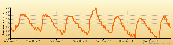
Temperature variation graph for the last seven days
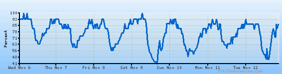
Humidity Variation Graph
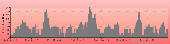
Wind speed
Weather Station: Alicante / El Altet (latitude 38-17N, longitude 000-33W)
Local Time:
Alicante / El Altet is in the "Europe/Madrid" timezone.
The "Europe/Madrid" timezone uses a Standard Time (ST) / Daylight Saving Time (DST) alternation scheme, and it currently is in ST (since Sunday, 27 October 2024, 02:00 AM local time). During ST, the timezone abbreviation is CET and the offset to Universal Time (UTC, GMT or Zulu) is +1:00 hours.
Alicante / El Altet will exit standard time (entering DST) on Sunday, 30 March 2025, at 02:00 AM local time, when clocks will be turned forward 1 hour to Sunday, 30 March 2025, 03:00 AM local daylight time. During DST, the timezone abbreviation is CEST and the offset to UTC will be +2:00 hours.
Weather and Temperature in Spain
Popular Weather Searches:
 If you own or manage a travel-related business such as a hotel, a bed-and-breakfast, a restaurant, a pub or a cafeteria, you can create a web page for your business for free on Titi Tudorancea Travel Info. » |