| Published in Weather / Ohio Weather Temperature |
Weather in Athens City (Albany Village), Ohio
Current Conditions (Thursday, April 3, 2025 at 05:15 America/New_York time)
Temperature: 63°F (17°C) |
Forecast Overview
Thu Apr 3 
70°F 52°F 21°C 11°C Chance of heavy rain almost all day.
detailsFri Apr 4 59°F 50°F 15°C 10°C Chance of heavy rain at various times.
detailsSat Apr 5 72°F 52°F 22°C 11°C Chance of rain at various times.
detailsSun Apr 6 63°F 34°F 17°C 1°C Chance of heavy rain at various times.
detailsMon Apr 7 
41°F 34°F 5°C 1°C Chance of light rain at various times. Chance of light snow in the morning.
detailsTue Apr 8 
37°F 27°F 3°C -3°C Chance of rain before sunrise. Chance of snow in the afternoon.
detailsWed Apr 9 
46°F 23°F 8°C -5°C Partly cloudy skies.
detailsThu Apr 10 
45°F 34°F 7°C 1°C Mostly cloudy skies.
detailsFri Apr 11 
55°F 34°F 13°C 1°C Chance of light rain late at night.
details
Detailed Forecast
| Thursday, April 3 | sunrise: 07:12 sunset: 19:53 |
| Low around 52°F (11°C), high around 69°F (21°C). Chance of heavy rain most of the day except from 5 am to 8 am. The precipitation may fall as scattered showers of varying intensity. Estimated precipitation: 1.36 in (34.4375 mm). Overcast skies. Wind: 16 mph (25 km/h). |
| Time | Skies | Conditions | Temp | Wind | Humidity | Soil Moisture |
| 23:00 02:00 | Overcast. Precipitation: 0 in (0.0625 mm). | 67°F (19°C) | 16 mph (25 km/h) | 79% | 0.329% | |
| 02:00 05:00 | Chance of scattered rain showers. Precipitation: 0.09 in (2.25 mm). | 66°F (19°C) | 12 mph (20 km/h) | 89% | 0.34% | |
| 05:00 08:00 | Overcast. Precipitation: 0.16 in (4 mm). | 66°F (19°C) | 14 mph (22 km/h) | 89% | 0.346% | |
| 08:00 11:00 | Chance of rain. Precipitation: 0.04 in (1.125 mm). | 64°F (18°C) | 11 mph (17 km/h) | 90% | 0.341% | |
| 11:00 14:00 | Chance of light rain. Precipitation: 0.01 in (0.375 mm). | 63°F (17°C) | 9 mph (14 km/h) | 90% | 0.337% | |
| 14:00 17:00 | Chance of rain. Precipitation: 0.08 in (2.125 mm). | 62°F (17°C) | 6 mph (9 km/h) | 92% | 0.342% | |
| 17:00 20:00 | Chance of heavy rain. Precipitation: 0.47 in (12.0625 mm). | 59°F (15°C) | 4 mph (6 km/h) | 98% | 0.38% | |
| 20:00 23:00 | Chance of heavy rain. Precipitation: 0.49 in (12.4375 mm). | 53°F (12°C) | 6 mph (10 km/h) | 97% | 0.415% |
| Friday, April 4 | sunrise: 07:10 sunset: 19:54 |
| Low around 50°F (10°C), high around 59°F (15°C). Chance of heavy rain early in the morning (until 8 am), late in the afternoon (between 2 pm and 5 pm) and again at night (after 8 pm). Estimated precipitation: 2 in (51.3125 mm). Overcast skies. Wind: 9 mph (15 km/h). |
| Time | Skies | Conditions | Temp | Wind | Humidity | Soil Moisture |
| 23:00 02:00 | Chance of rain. Precipitation: 0.2 in (5.1875 mm). | 51°F (11°C) | 9 mph (15 km/h) | 98% | 0.389% | |
| 02:00 05:00 | Chance of heavy rain. Precipitation: 1.2 in (30.5 mm). | 51°F (11°C) | 8 mph (13 km/h) | 99% | 0.43% | |
| 05:00 08:00 | Chance of rain. Precipitation: 0.08 in (1.9375 mm). | 50°F (10°C) | 5 mph (8 km/h) | 97% | 0.395% | |
| 08:00 11:00 | Overcast. Precipitation: 0.01 in (0.25 mm). | 52°F (11°C) | 6 mph (10 km/h) | 96% | 0.383% | |
| 11:00 14:00 | Overcast. | 54°F (12°C) | 6 mph (10 km/h) | 94% | 0.375% | |
| 14:00 17:00 | Chance of heavy rain. Precipitation: 0.45 in (11.3125 mm). | 55°F (13°C) | 6 mph (9 km/h) | 98% | 0.402% | |
| 17:00 20:00 | Overcast. Precipitation: 0.05 in (1.25 mm). | 55°F (13°C) | 5 mph (8 km/h) | 99% | 0.385% | |
| 20:00 23:00 | Chance of light rain. Precipitation: 0.03 in (0.875 mm). | 57°F (14°C) | 4 mph (7 km/h) | 99% | 0.384% |
| Saturday, April 5 | sunrise: 07:09 sunset: 19:55 |
| Low around 52°F (11°C), high around 72°F (22°C). Chance of rain early in the morning (between 2 am and 8 am) and again from late afternoon till 11 pm. The precipitation may fall as scattered showers of varying intensity. Estimated precipitation: 0.68 in (17.375 mm). Overcast skies. Wind: 14 mph (22 km/h). |
| Time | Skies | Conditions | Temp | Wind | Humidity | Soil Moisture |
| 23:00 02:00 | Overcast. Precipitation: 0.06 in (1.5625 mm). | 57°F (14°C) | 4 mph (6 km/h) | 100% | 0.381% | |
| 02:00 05:00 | Chance of scattered rain showers. Precipitation: 0.06 in (1.5625 mm). | 60°F (16°C) | 7 mph (11 km/h) | 97% | 0.38% | |
| 05:00 08:00 | Chance of scattered rain showers. Precipitation: 0.07 in (1.6875 mm). | 63°F (17°C) | 9 mph (14 km/h) | 94% | 0.379% | |
| 08:00 11:00 | Overcast. Precipitation: 0.01 in (0.25 mm). | 67°F (20°C) | 14 mph (22 km/h) | 88% | 0.372% | |
| 11:00 14:00 | Overcast. Precipitation: 0 in (0.0625 mm). | 71°F (22°C) | 13 mph (21 km/h) | 79% | 0.366% | |
| 14:00 17:00 | Chance of scattered rain showers. Precipitation: 0.04 in (1.0625 mm). | 71°F (21°C) | 6 mph (9 km/h) | 84% | 0.366% | |
| 17:00 20:00 | Chance of scattered rain showers. Precipitation: 0.14 in (3.5625 mm). | 63°F (17°C) | 6 mph (9 km/h) | 96% | 0.382% | |
| 20:00 23:00 | Chance of rain. Precipitation: 0.3 in (7.625 mm). | 52°F (11°C) | 7 mph (11 km/h) | 98% | 0.398% |
| Sunday, April 6 | sunrise: 07:07 sunset: 19:56 |
| Low around 34°F (1°C), high around 63°F (17°C). Chance of heavy rain early in the morning (until 8 am) and late in the afternoon (between 2 pm and 5 pm). Estimated precipitation: 1.9 in (48.375 mm). Overcast skies. Wind: 12 mph (19 km/h). |
| Time | Skies | Conditions | Temp | Wind | Humidity | Soil Moisture |
| 23:00 02:00 | Chance of heavy rain. Precipitation: 0.53 in (13.375 mm). | 49°F (9°C) | 5 mph (7 km/h) | 98% | 0.416% | |
| 02:00 05:00 | Chance of heavy rain. Precipitation: 0.4 in (10.1875 mm). | 45°F (7°C) | 8 mph (13 km/h) | 96% | 0.414% | |
| 05:00 08:00 | Chance of heavy rain. Precipitation: 0.41 in (10.5 mm). | 43°F (6°C) | 8 mph (13 km/h) | 97% | 0.423% | |
| 08:00 11:00 | Overcast. Precipitation: 0.22 in (5.5625 mm). | 43°F (6°C) | 10 mph (16 km/h) | 95% | 0.403% | |
| 11:00 14:00 | Overcast. | 43°F (6°C) | 10 mph (17 km/h) | 92% | 0.392% | |
| 14:00 17:00 | Chance of rain. Precipitation: 0.12 in (2.9375 mm). | 36°F (2°C) | 12 mph (19 km/h) | 96% | 0.4% | |
| 17:00 20:00 | Overcast. Precipitation: 0.22 in (5.6875 mm). | 34°F (1°C) | 11 mph (17 km/h) | 95% | 0.398% | |
| 20:00 23:00 | Overcast. Precipitation: 0 in (0.125 mm). | 34°F (1°C) | 8 mph (13 km/h) | 93% | 0.388% |
| Monday, April 7 | sunrise: 07:06 sunset: 19:57 |
| Low around 34°F (1°C), high around 42°F (5°C). Chance of light rain at night (before 2 am), in the morning and early afternoon (between 8 am and 2 pm). Chance of light snow early in the morning (between 5 am and 8 am). Estimated precipitation: 0.07 in (1.6875 mm). Mostly cloudy skies. Wind: 8 mph (14 km/h). |
| Time | Skies | Conditions | Temp | Wind | Humidity | Soil Moisture |
| 23:00 02:00 | Chance of light rain. Precipitation: 0 in (0.0625 mm). | 34°F (1°C) | 8 mph (13 km/h) | 94% | 0.383% | |
| 02:00 05:00 | Overcast. Precipitation: 0.01 in (0.1875 mm). | 34°F (1°C) | 5 mph (9 km/h) | 97% | 0.38% | |
| 05:00 08:00 | Chance of light snow. Precipitation: 0.02 in (0.4375 mm). | 35°F (2°C) | 4 mph (6 km/h) | 100% | 0.378% | |
| 08:00 11:00 | Chance of light rain. Precipitation: 0.02 in (0.625 mm). | 37°F (3°C) | 2 mph (4 km/h) | 99% | 0.376% | |
| 11:00 14:00 | Chance of light rain. Precipitation: 0.01 in (0.1875 mm). | 39°F (4°C) | 2 mph (4 km/h) | 96% | 0.374% | |
| 14:00 17:00 | Overcast. Precipitation: 0 in (0.125 mm). | 41°F (5°C) | 5 mph (9 km/h) | 92% | 0.373% | |
| 17:00 20:00 | Clear. Precipitation: 0 in (0.0625 mm). | 38°F (3°C) | 6 mph (10 km/h) | 97% | 0.371% | |
| 20:00 23:00 | Mostly clear. | 36°F (2°C) | 8 mph (14 km/h) | 97% | 0.37% |
| Tuesday, April 8 | sunrise: 07:04 sunset: 19:58 |
| Low around 26°F (-3°C), high around 38°F (3°C). Chance of rain between 11 pm and 2 am. Chance of snow late in the afternoon (between 2 pm and 5 pm). Estimated precipitation: 0.07 in (1.6875 mm). Mostly cloudy skies. Wind: 15 mph (24 km/h). |
| Time | Skies | Conditions | Temp | Wind | Humidity | Soil Moisture |
| 23:00 02:00 | Chance of light rain. Precipitation: 0.01 in (0.3125 mm). | 37°F (3°C) | 12 mph (19 km/h) | 97% | 0.37% | |
| 02:00 05:00 | Clear. Precipitation: 0.04 in (1.125 mm). | 32°F (-0°C) | 11 mph (18 km/h) | 89% | 0.369% | |
| 05:00 08:00 | Overcast. | 27°F (-3°C) | 10 mph (16 km/h) | 90% | 0.365% | |
| 08:00 11:00 | Overcast. | 32°F (-0°C) | 14 mph (23 km/h) | 57% | 0.359% | |
| 11:00 14:00 | Overcast. Precipitation: 0 in (0.0625 mm). | 35°F (2°C) | 15 mph (24 km/h) | 45% | 0.352% | |
| 14:00 17:00 | Chance of light snow. Precipitation: 0 in (0.0625 mm). | 37°F (3°C) | 15 mph (24 km/h) | 52% | 0.345% | |
| 17:00 20:00 | Clear. Precipitation: 0 in (0.125 mm). | 31°F (-0°C) | 12 mph (19 km/h) | 64% | 0.341% | |
| 20:00 23:00 | Clear. | 29°F (-2°C) | 8 mph (14 km/h) | 68% | 0.34% |
| Wednesday, April 9 | sunrise: 07:02 sunset: 19:59 |
| Low around 24°F (-5°C), high around 47°F (8°C). Partly cloudy skies. Wind: 7 mph (12 km/h). |
| Time | Skies | Conditions | Temp | Wind | Humidity | Soil Moisture |
| 23:00 02:00 | Clear. | 26°F (-3°C) | 6 mph (10 km/h) | 72% | 0.339% | |
| 02:00 05:00 | Clear. | 24°F (-4°C) | 5 mph (8 km/h) | 83% | 0.34% | |
| 05:00 08:00 | Sunny. | 28°F (-2°C) | 3 mph (5 km/h) | 71% | 0.341% | |
| 08:00 11:00 | Sunny. | 40°F (4°C) | 6 mph (10 km/h) | 43% | 0.341% | |
| 11:00 14:00 | Overcast. | 46°F (8°C) | 7 mph (12 km/h) | 35% | 0.338% | |
| 14:00 17:00 | Overcast. | 47°F (8°C) | 6 mph (10 km/h) | 37% | 0.333% | |
| 17:00 20:00 | Overcast. | 38°F (3°C) | 3 mph (4 km/h) | 63% | 0.331% | |
| 20:00 23:00 | Overcast. | 35°F (2°C) | 1 mph (1 km/h) | 67% | 0.33% |
| Thursday, April 10 | sunrise: 07:01 sunset: 20:00 |
| Low around 34°F (1°C), high around 45°F (7°C). Estimated precipitation: 0 in (0.125 mm). Mostly cloudy skies. Wind: 5 mph (8 km/h). |
| Time | Skies | Conditions | Temp | Wind | Humidity | Soil Moisture |
| 23:00 02:00 | Overcast. | 34°F (1°C) | 4 mph (6 km/h) | 71% | 0.33% | |
| 02:00 05:00 | Overcast. | 35°F (2°C) | 4 mph (6 km/h) | 72% | 0.329% | |
| 05:00 08:00 | Overcast. | 36°F (2°C) | 4 mph (7 km/h) | 90% | 0.329% | |
| 08:00 11:00 | Overcast. | 42°F (6°C) | 5 mph (8 km/h) | 77% | 0.327% | |
| 11:00 14:00 | Overcast. Precipitation: 0 in (0.125 mm). | 45°F (7°C) | 3 mph (5 km/h) | 67% | 0.33% | |
| 14:00 17:00 | Overcast. | 45°F (7°C) | 1 mph (1 km/h) | 70% | 0.334% | |
| 17:00 20:00 | Overcast. | 42°F (5°C) | 1 mph (2 km/h) | 82% | 0.338% | |
| 20:00 23:00 | Clear. | 38°F (3°C) | 1 mph (2 km/h) | 91% | 0.34% |
| Friday, April 11 | sunrise: 06:59 sunset: 20:01 |
| Low around 34°F (1°C), high around 55°F (13°C). Chance of light rain late at night (after 8 pm). Estimated precipitation: 0.01 in (0.1875 mm). More clouds than sun. Wind: 5 mph (9 km/h). |
| Time | Skies | Conditions | Temp | Wind | Humidity | Soil Moisture |
| 23:00 02:00 | Partly cloudy. | 35°F (1°C) | 1 mph (1 km/h) | 95% | 0.342% | |
| 02:00 05:00 | Mostly clear, with a few passing clouds. | 34°F (1°C) | 2 mph (3 km/h) | 94% | 0.343% | |
| 05:00 08:00 | Sunny. | 37°F (3°C) | 3 mph (5 km/h) | 90% | 0.344% | |
| 08:00 11:00 | Mostly cloudy. | 50°F (10°C) | 4 mph (6 km/h) | 58% | 0.342% | |
| 11:00 14:00 | Mostly cloudy. | 52°F (11°C) | 5 mph (7 km/h) | 56% | 0.341% | |
| 14:00 17:00 | Overcast. Precipitation: 0 in (0.0625 mm). | 51°F (11°C) | 5 mph (9 km/h) | 63% | 0.34% | |
| 17:00 20:00 | Sunny. | 45°F (7°C) | 4 mph (7 km/h) | 86% | 0.341% | |
| 20:00 23:00 | Chance of light rain. Precipitation: 0 in (0.125 mm). | 45°F (7°C) | 3 mph (4 km/h) | 88% | 0.343% |
Climate Chart
» Athens City (Albany Village) Climate Chart
Places with a similar climate: Hamilton, Butler County (OH), Lancaster, Fairfield County (OH), Parkersburg (WV), Bloomington, Monroe County (IN), Clarksburg (WV), York (PA), Zanesville (OH), Columbus / Bakalar (IN), Dayton (OH), Terre Haute (IN), Mount Carmel (IL), Wilmington (OH), Martinsburg (WV), Point Pleasant, Mason County (WV), Cumberland (MD), Middletown City, Butler County (OH), Covington / Cincinnati (KY), Cincinnati (OH), Indianapolis City, Boone County (IN), Shelbyville (IN), New Philadelphia (OH), Springfield (OH), Columbus (OH), Columbus (OH), Dayton (OH).
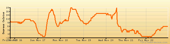
Temperature variation graph for the last seven days
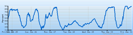
Humidity Variation Graph
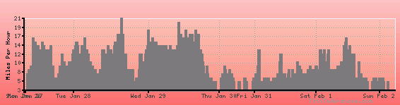
Wind speed
Weather Station: Ohio University, or Gordon K. Bush Airport, Snyder Field (latitude 39-13N, longitude 082-14W)
Local Time:
Athens City (Albany Village) is in the "America/New_York" timezone.
The "America/New_York" timezone uses a Standard Time (ST) / Daylight Saving Time (DST) alternation scheme, and it currently is in DST (since Sunday, 9 March 2025, 03:00 AM local time). During DST, the timezone abbreviation is EDT and the offset to Universal Time (UTC, GMT or Zulu) is -4:00 hours.
Athens City (Albany Village) will exit DST (returning to standard time) on Sunday, 2 November 2025, at 02:00 AM local time, when clocks will be turned backward 1 hour to Sunday, 2 November 2025, 01:00 AM local standard time. During ST, the timezone abbreviation is EST and the offset to UTC will be -5:00 hours.
Weather and Temperature in Ohio
Popular Weather Searches:
 If you own or manage a travel-related business such as a hotel, a bed-and-breakfast, a restaurant, a pub or a cafeteria, you can create a web page for your business for free on Titi Tudorancea Travel Info. » |