| Published in Attractions / Places of Interest |
Tourist Attractions in La Palma, Spain
La Palma, Spain. ![]()
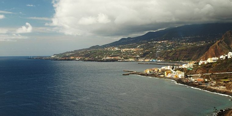
La Palma, also San Miguel de La Palma, is the most north-westerly island of the Canary Islands, Spain. There are a few nice towns, but the main attraction is the countryside. Spectacular volcanic landscapes reaching up above the clouds with dense vegetation in the valleys make for some spectacular hiking.
The highest point on the island, El Roque de los Muchachos, is easily accessible by car most of the year and the views from there are spectacular and provide a good introduction to the geography of the island (note that access is restricted at night as this is the site of a major international astronomical observatory -- always read the signposts -- also note that roads and trails can be closed for a few days in the winter due to snow).
There is a very extensive network of marked walking trails over the whole island which are well signposted and walking maps are available from the tourist office in Santa Cruz. Along the northeast coast, you'll find masses of intricately terraced crops (especially bananas) interlaced with small towns and villages.
The capital of the island, Santa Cruz, has lots of well preserved old buildings and cobblestone streets. Along Avenida Maritima you can see old Canarian balconies made from the Canary pine.
• Water tunnels. The most famous structures of La Palma are the minas galerias which carry the water from sources in the mountains to cities, villages and farms (mainly banana plantations). La Palma receives almost all of its water supply due to the mar de nubes (sea of clouds), stratocumulus cloud at 1,200 m (3,937 ft)-1,600 m (5,249 ft) altitude, carried on the prevailing wind which blows from the north-east trade winds.
The water condenses on the long needles of the trees and other vegetation, it then either drips onto the ground or runs down the trunk etc., into the ground. Eventually it collects inside the rock-strata, and is then drained via the galerias into aqueducts and pipes for distribution.
The galerias have been cut into the rocks over centuries. To visit the galerias a permit is required. It is possible to walk alongside many of the aqueducts, a popular activity for tourists (similar to the levadas of Madeira). The tour to the Marcos y Corderos waterfall and springs is also popular.
• Observatorio del Roque de los Muchachos. Due to the location of the island and the height of its mountains, some 2,400 m (7,874 ft) above sea level, a number of international observatories have been built on the Roque de los Muchachos. The particular geographical position and climate cause clouds to form between 1,000 m (3,281 ft) and 2,000 m (6,562 ft), usually leaving the observatories with a clear sky. Often, the view from the top of the volcano is a sea of clouds covering the eastern part of the island.
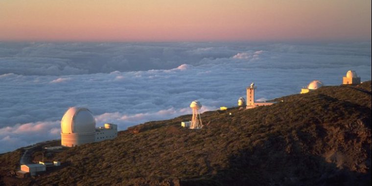
Observatorio del Roque de los Muchachos. ![]()
• Lighthouse of Fuencaliente. An active lighthouse on the island. It is the second lighthouse to be built at this site, which marks the southern end of the island. The original lighthouse which was opened in 1903, still exists, and consists of a 12m tower at the front of a single storey house. It was badly damaged by an earthquake in 1939, and had to be substantially rebuilt.
The newer lighthouse opened in 1985, has a red and white painted concrete tower standing 24m high. With a focal height of 36m above the sea, its light can be seen for 14 nautical miles, and consists of three flashes of white light every 18 seconds.
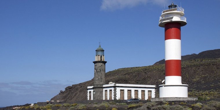
Lighthouse of Fuencaliente. ![]()
• National Park de la Caldera de Taburiente (Parque Nacional de la Caldera de Taburiente) is a large geological feature on the island. It contains the enormous expanse of the Caldera de Taburiente which dominates the northern part of the island, and was designated as a national park in 1954. The telescopes of the Roque de los Muchachos Observatory are situated very close to the summit.
The caldera is about 10 km across, and in places the walls tower 2000 m over the caldera floor. The highest point is the Roque de los Muchachos on the northern wall, at 2426 m altitude, which can be reached by road. The Cumbrecita is at a lower point in the south-eastern part of the caldera's rim, giving a good view into the Caldera. In the south-west the caldera opens to the sea, through a riverbed known as Barranco de las Angustias. The Cumbre Nueva is a ridge that starts at the caldera and continues to the south.
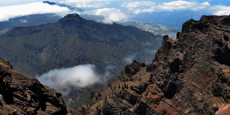
National Park de la Caldera de Taburiente. ![]()
• Parque Arqueologico de Belmaco (also known as Cueva de Belmaco) is one of the most important archaeological sites of the Canary Islands, located in the Villa de Mazo.
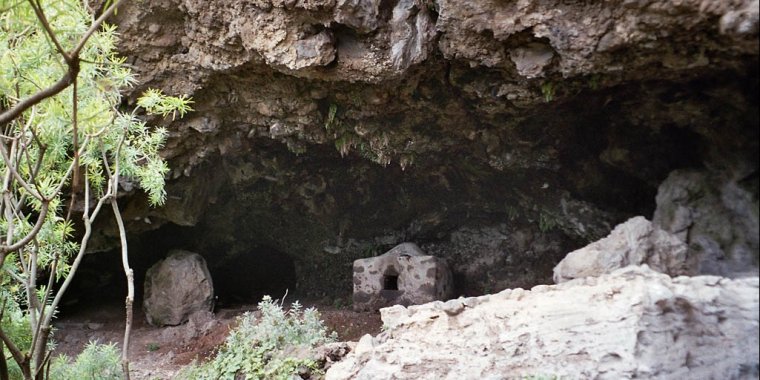
Cueva de Belmaco. ![]()
• Roque de Los Muchachos is a rocky mound at the highest point on the island. The rocks are found at an elevation of 2,423 m above sea level, not far from the Observatorio del Roque de los Muchachos. The rocks are contained with the Parque Nacional de la Caldera de Taburiente.
From the Roque, one can see the islands of Tenerife, El Hierro and La Gomera.
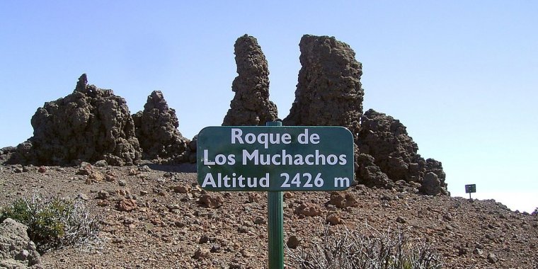
Roque de los Muchachos. ![]()
• Charco Azul is a group of natural pools located on the coast of the municipality of San Andrés y Sauces. They are located next to the pedestrian promenade of El Melonar, between Villa de San Andrés and Puerto Espíndola. It is called El Charco Azul because of its shape and because of the different color that water acquires depending on the pool. On the coast are also small tourist center of the municipality.
These beautiful natural pools have a large adult pool, a children's pool, and a pool known as Charco de las Damas.
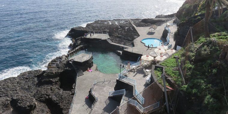
Charco Azul. ![]()
• Eco Finca Platano Logico (near Puerto Naos). A mostly organic banana orchard with visitor center.
• La Palma Maritime Museum, Plaza de la Alameda (Santa Cruz de la Palma).
• Parque Cultural La Zarza, San Antonio, Garafia. One of the most important archaeological resources of the Canarian archipelago.
Parque Cultural La Zarza. ![]()
• Archaeological Museum Benahoritas, Calle de Las Adelfas 3, Los Llanos de Aridane. It is a modern building inaugurated in 2007, which houses a permanent exhibition on the Benahoaritas, former settlers of the island of La Palma before the conquest and its incorporation to the Crown of Castile in the late 15th century . The museum shows the habitat, the industries, the use of the environment and the magic-religious beliefs of the aborigines. (Wikivoyage, Wikipedia)
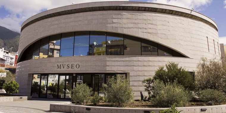
Archaeological Museum Benahoritas. ![]()
See also La Palma in Pictures
YOU MAY ALSO LIKE


 If you own or manage a travel-related business such as a hotel, a bed-and-breakfast, a restaurant, a pub or a cafeteria, you can create a web page for your business for free on Titi Tudorancea Travel Info. » |