| Published in Tourist Info / Highways |
Tauern Autobahn, Austria
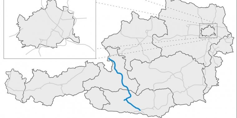
Map of austrian freeway A10. ![]()
The Tauern Autobahn (A 10) is an autobahn (motorway) in Austria. It starts at the Salzburg junction with the West Autobahn (A1), runs southwards, crosses the Tauern mountain range on the main chain of the Alps and leads to the Süd Autobahn (A2) and Karawanken Autobahn (A11) at Villach in Carinthia.
The Tauern Autobahn is part of the European route E55 from Sweden to Greece, its southern section also of the E66 from Italy (South Tyrol) to Hungary.
It is 192 km (119 mi) long, 24 km (15 mi) of which are in 12 tunnels. The best known of these are the Tauern Tunnel and the Katschberg Tunnel that originally both had only a single bore, leading to chronic traffic congestions especially during summer holidays. The second bore of the Katschberg Tunnel opened in 2009, the second bore of the Tauern Tunnel in June 2011—after 35 years of traffic.
From the West Autobahn junction at the Salzburg suburb of Wals-Siezenheim near the German border, the motorway runs southwards through the Salzach Valley between the Berchtesgaden Alps, with the Untersberg massif to the west and the Salzkammergut Mountains to the east.
The first tunnel is at Golling in the southern Tennengau, where the Salzach breaks through the Tennengebirge. It passes Hohenwerfen Castle and reaches Bischofshofen in the Pongau district, then turns eastwards along the Salzburg Slate Alps to Eben and again southwards to Altenmarkt in the Enns Valley.
From Flachau, the motorway climbs the northern slope of the Niedere Tauern range with the 6.4 km (4.0 mi) long Tauern Tunnel at an elevation of 1,340 m (4,400 ft) and runs through the Salzburg Lungau region to the toll plaza at Sankt Michael. From here it reaches Rennweg in Carinthia through the 5.9 km (3.7 mi) long Katschberg Tunnel, leading downhill from the Hohe Tauern range to Spittal in the Drava Valley.
The southern section of the Tauern Autobahn runs southeastwards along the Drava between the Gurktal and Gailtal Alps to the Villach junction.
Length: 192.7 km (119.7 mi)
Regions: Salzburg, Carinthia.
Major cities: Salzburg, Villach.
Speed limit: In a variance to the general Austrian motorway speed limit of 130 km/h (81 mph), a special environmental speed limit of 110 km/h (68 mph) is in force on the Tauern Autobahn between 10:00 PM and 5:00 AM. While on the motorway voluntary stops, U-turns and backward driving are prohibited.
Junctions
The motorway links to the following additional motorways and major roads:
From
— A1 (West Autobahn) at Wals-Siezenheim
To
— A2 (Süd Autobahn), A11 (Karawanken Autobahn) at Villach
Tolls
The section between the Flachau and Rennweg junctions, including the Tauern and Katschberg Tunnels, is a so-called special toll route. In this area instead of the general Austrian vignette requirement, extra tolls (a one–way Maut currently at eleven euros) are paid in cash or by credit card at the toll plaza at Sankt Michael, or via a Videomaut prepaid system. For driving on all other sections of the A10 the standard vignette is required.
See Autobahn Tolls (Highway Toll Sticker / Vignette), Austria
Source
• www.wikipedia.org
YOU MAY ALSO LIKE

 If you own or manage a travel-related business such as a hotel, a bed-and-breakfast, a restaurant, a pub or a cafeteria, you can create a web page for your business for free on Titi Tudorancea Travel Info. » |