| Published in Attractions / Places of Interest |
Pont du Gard, France
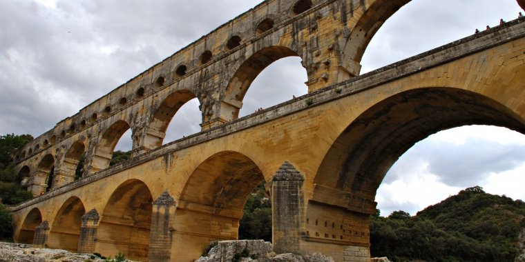
Pont du Gard. Photo: Cătălin Kislinger / Titi Tudorancea Travel Info
The Pont du Gard is an ancient Roman aqueduct that crosses the Gardon River near the town of Vers-Pont-du-Gard in southern France. The Pont du Gard is the highest of all elevated Roman aqueducts, and, along with the Aqueduct of Segovia, one of the best preserved. It was added to UNESCO's list of World Heritage Sites in 1985 because of its historical importance.
The aqueduct bridge is part of the Nîmes aqueduct, a 50-kilometre (31 mi) system built in the first century AD to carry water from a spring at Uzès to the Roman colony of Nemausus (Nîmes). Because of the uneven terrain between the two points, the mostly underground aqueduct followed a long, winding route that called for a bridge across the gorge of the Gardon River.
The bridge has three tiers of arches, and stands 48.8 m (160 ft) high. The whole aqueduct descends in height by only 17 m (56 ft) over its entire length, while the bridge descends by a mere 2.5 centimetres (1 in) – a gradient of only 1 in 3,000 – which is indicative of the great precision that Roman engineers were able to achieve, using only simple technology.
The aqueduct formerly carried an estimated 200,000 m3 (44,000,000 imp gal) of water a day to the fountains, baths and homes of the citizens of Nîmes. It may have been in use as late as the 6th century, with some parts used for significantly longer, but a lack of maintenance after the 4th century led to clogging by mineral deposits and debris that eventually choked off the flow of water.
After the Roman Empire collapsed and the aqueduct fell into disuse, the Pont du Gard remained largely intact, due to the importance of its secondary function, as a toll bridge. For centuries the local lords and bishops were responsible for its upkeep, in exchange for the right to levy tolls on travellers using it to cross the river, although some of its stones were looted and serious damage was inflicted on it in the 17th century. It attracted increasing attention starting in the 18th century, and became an important tourist destination.
It underwent a series of renovations between the 18th and 21st centuries, commissioned by the local authorities and the French state, that culminated in 2000 with the opening of a new visitor centre and the removal of traffic and buildings from the bridge and the area immediately around it. Today it is one of France's most popular tourist attractions, and has attracted the attention of a succession of literary and artistic visitors.
Opening hours
The Pont du Gard site is open to the public all year round. If you are visiting the aqueduct you can use the secure car parks on the left and right banks of the river.
- From 9:00 to 17:00 in january, february, march, november and december
- From 9:00 to 18:00 in april, september and october
- From 9:00 to 21:00 in may and june
- From 9:00 to 23:30 in july and august
Rates
Entrance fee ticket:
• Discovery Pass (Pont du Gard, Museum, Ciné, Ludo, the Mémoires de Garrigue path, Exhibition)
Adult rate: 8.50 euro / pers
Reduced price: 6 euro / pers
Child rate (from 6 to 17 years): 6 €euro/ pers
Free under -6 years
• Pass Aqueduct: Discovery Pass + guided tour of the top level of the Aqueduct
Adult rate: 11.50 euro / pers
Reduced price: 9 euro / pers
Child rate (6 to 17 years): 6 euro / pers
Free under -6 years
• Prestige Pass: Aqueduct Pass + guided tour of the Pont du Gard + Museum
Adult rate: 15.50 euro / pers
Reduced price: 13 euro / pers
Child rate (6 to 17 years): 6 euro / pers
Free under -6 years
• Evening rates for lighting:
Adult rate: 3 euro
Reduced price: 2 euro
Free under -17 years
Parking included and strictly reserved for the customers of the site.
Go
The Pont du Gard is located between Remoulins (RN 100) and Vers-Pont du Gard (D 81).
By car From the A9 motorway, take exit 23 at Remoulins towards Uzès, then follow the signs to the right or left banks. Location: Nîmes is 27 km away, Avignon is 21 km away.
Guarded parking areas, open from 7:00 to 01:00 are available, for the customers only. Their capacity is 800 places in the rive gauche, and 600 places in the right bank. The parking area is closed to the public between 01:00 and 7:00, a fee of 43 euros will be charged to any vehicle parked in the parking between 01:00 and 07:00 am.
By train: Nîmes and Avignon train stations are served by the TGV. The Paris–Nîmes TGV train, which has been running since June 2001, takes 2 hours 50 minutes.
By bus: in departure from Avignon or Alès - Line A15, in departure from Nîmes - Line B21.
Description of the bridge
Built on three levels, the Pont is 49 m (161 ft) high above the river at low water and 274 m (899 ft) long. Its width varies from 9 m (30 ft) at the bottom to 3 m (9.8 ft) at the top. The three levels of arches are recessed, with the main piers in line one above another. The span of the arches varies slightly, as each was constructed independently to provide flexibility to protect against subsidence.
The first level of the Pont du Gard adjoins a road bridge that was added in the 18th century. The water conduit or specus, which is about 1.8 m (6 ft) high and 1.2 m (4 ft) wide, is carried at the top of the third level. The upper levels of the bridge are slightly curved in the upstream direction. It was long believed that the engineers had designed it this way deliberately to strengthen the bridge's structure against the flow of water, like a dam wall.
However, a microtopographic survey carried out in 1989 showed that the bend is caused by the stone expanding and contracting by about 5 mm (0.20 in) a day under the heat of the sun. Over the centuries, this process has produced the current deformation.
The aqueduct as a whole would have been a very expensive undertaking; Émile Espérandieu estimated the cost to be over 30 million sesterces, equivalent to 50 years' pay for 500 new recruits in a Roman legion.
History
The construction of the aqueduct has long been credited to Augustus' son-in-law and aide, Marcus Vipsanius Agrippa, around the year 19 BC. At the time, he was serving as aedile, the senior magistrate responsible for managing the water supply of Rome and its colonies. Espérandieu, writing in 1926, linked the construction of the aqueduct with Agrippa's visit to Narbonensis in that year. Newer excavations suggest the construction may have taken place between 40 and 60 AD.
Tunnels dating from the time of Augustus had to be bypassed by the builders of the Nîmes aqueduct, and coins discovered in the outflow in Nîmes are no older than the reign of the emperor Claudius (41–54 AD). On this basis, a team led by Guilhem Fabre has argued that the aqueduct must have been completed around the middle of the 1st century AD.[36] It is believed to have taken about fifteen years to build, employing between 800 and 1,000 workers.
From the 4th century onwards, the aqueduct's maintenance was neglected as successive waves of invaders disrupted the region. It became clogged with debris, encrustations and plant roots, greatly reducing the flow of the water. The resulting deposits in the conduit, consisting of layers of dirt and organic material, are up to 50 cm (20 in) thick on each wall.
An analysis of the deposits originally suggested that it had continued to supply water to Nîmes until as late as the 9th century, but more recent investigations suggest that it had gone out of use by about the sixth century, though parts of it may have continued to be used for significantly longer.
Although some of its stones were plundered for use elsewhere, the Pont du Gard remained largely intact. Its survival was due to its use as a toll bridge across the valley. In the 13th century the French king granted the seigneurs of Uzès the right to levy tolls on those using the bridge. The right later passed to the Bishops of Uzès. In return, they were responsible for maintaining the bridge in good repair.
However, it suffered serious damage during the 1620s when Henri, Duke of Rohan made use of the bridge to transport his artillery during the wars between the French royalists and the Huguenots, whom he led. To make space for his artillery to cross the bridge, the duke had one side of the second row of arches cut away to a depth of about one-third of their original thickness. This left a gap on the lowest deck wide enough to accommodate carts and cannons, but severely weakened the bridge in the process.
In 1703 the local authorities renovated the Pont du Gard to repair cracks, fill in ruts and replace the stones lost in the previous century. A new bridge was built by the engineer Henri Pitot in 1743–47 next to the arches of the lower level, so that the road traffic could cross on a purpose-built bridge.
The novelist Alexandre Dumas was strongly critical of the construction of the new bridge, commenting that "it was reserved for the eighteenth century to dishonour a monument which the barbarians of the fifth had not dared to destroy." The Pont du Gard continued to deteriorate and by the time Prosper Mérimée saw it in 1835 it was at serious risk of collapse from erosion and the loss of stonework.
Napoleon III, who had a great admiration for all things Roman, visited the Pont du Gard in 1850 and took a close interest in it. He approved plans by the architect Charles Laisné to repair the bridge in a project which was carried out between 1855–58, with funding provided by the Ministry of State.
The work involved substantial renovations that included replacing the eroded stone, infilling some of the piers with concrete to aid stability and improving drainage by separating the bridge from the aqueduct. Stairs were installed at one end and the conduit walls were repaired, allowing visitors to walk along the conduit itself in reasonable safety.
There have been a number of subsequent projects to consolidate the piers and arches of the Pont du Gard. It has survived three serious floods over the last century; in 1958 the whole of the lower tier was submerged by a giant flood that washed away other bridges, and in 1998 another major flood affected the area. A further flood struck in 2002, badly damaging nearby installations.
The Pont du Gard was added to UNESCO's list of World Heritage Sites in 1985 on the criteria of "Human creative genius; testimony to cultural tradition; significance to human history". The description on the list states: "The hydraulic engineers and ... architects who conceived this bridge created a technical as well as artistic masterpiece."
Tourism
The Pont du Gard has been a tourist attraction for centuries. The outstanding quality of the bridge's masonry led to it becoming an obligatory stop for French journeymen masons on their traditional tour around the country (see Compagnons du Tour de France), many of whom have left their names on the stonework.
From the 18th century onwards, particularly after the construction of the new road bridge, it became a famous staging-post for travellers on the Grand Tour and became increasingly renowned as an object of historical importance and French national pride.
The bridge has had a long association with French monarchs seeking to associate themselves with a symbol of Roman imperial power. King Charles IX of France visited in 1564 during his Grand Tour of France and was greeted with a grand entertainment laid on by the Duc d'Uzès. Twelve young girls dressed as nymphs came out of a cave by the riverside near the aqueduct and presented the king with pastry and preserved fruits.
A century later, Louis XIV and his court visited the Pont du Gard during a visit to Nîmes in January 1660 shortly after the signature of the Treaty of the Pyrenees. In 1786 his great-great-great-grandson Louis XVI commissioned the artist Hubert Robert to produce a set of paintings of Roman ruins of southern France to hang in the king's new dining room at the Palace of Fontainebleau, including a picture depicting the Pont du Gard in an idealised landscape. The commission was meant to reassert the ties between the French monarchy and the imperial past.
Napoleon III, in the mid-19th century, consciously identified with the Roman emperor Augustus and accorded great respect to Roman antiquities; his patronage of the bridge's restoration in the 1850s was essential to its survival.
By the 1990s the Pont du Gard had become a hugely popular tourist attraction but was congested with traffic – vehicles were still allowed to drive over the 1743 road bridge – and was cluttered with illegally built structures and tourist shops lining the river banks. As the architect Jean-Paul Viguier put it, the "appetite for gain" had transformed the Pont du Gard into "a fairground attraction".
In 1996 the General Council of the Gard département began a major four-year project to improve the area, sponsored by the French government, in conjunction with local sources, UNESCO and the EU. The entire area around the bridge was pedestrianised and a new visitor centre was built on the north bank to a design by Jean-Paul Viguier.
The redevelopment has ensured that the area around the Pont du Gard is now much quieter due to the removal of vehicle traffic, and the new museum provides a much improved historical context for visitors. The Pont du Gard is today one of France's top five tourist attractions, with 1.4 million visitors reported in 2001. (wikipedia.org/pontdugard.fr)
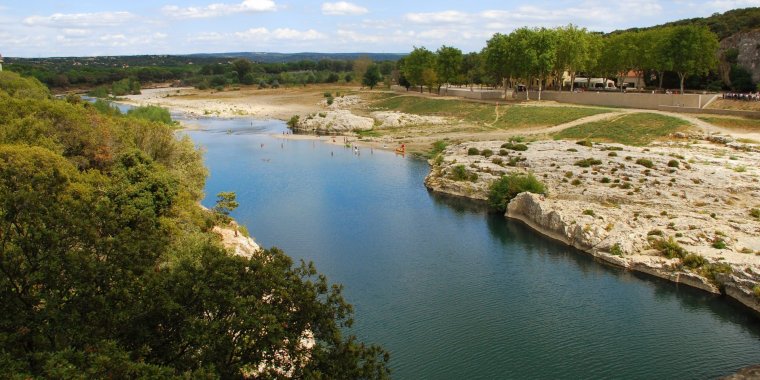
View from the Pont du Gard. Photo: Cătălin Kislinger / Titi Tudorancea Travel Info
YOU MAY ALSO LIKE


 If you own or manage a travel-related business such as a hotel, a bed-and-breakfast, a restaurant, a pub or a cafeteria, you can create a web page for your business for free on Titi Tudorancea Travel Info. » |