| Published in Tourist Info / Highways |
Bundesautobahn 3, Germany
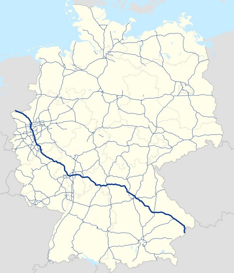
Map of Bundesautobahn 3, Germany. ![]()
Bundesautobahn 3 (Federal Motorway 3, short form Autobahn 3, abbreviated as BAB 3 or A 3) is an autobahn in Germany that links the German border with the Netherlands near Wesel in the northwest to then go to the A2/A516 in Oberhausen an ultimately to the south at the Austrian border near Passau, where it continues in Austria as the A8.
Major cities along its total length of 778 km (483 mi) include Oberhausen, Duisburg, Düsseldorf, Leverkusen, Cologne, Wiesbaden, Frankfurt, Würzburg, Nuremberg and Regensburg. The A 3 is a major connection between the Rhine-Ruhr area and southern Germany, resulting in heavy traffic.
Consequently, large parts have three lanes (plus a hard shoulder) in each direction, including a 300 km (187.5 mi) section between Oberhausen and Aschaffenburg.
The A 3 begins at the border crossing Elten in North Rhine-Westphalia as a four-lane continuation of the Dutch A 12. Until Oberhausen the highway runs on the right bank of the Lower Rhine past the cities Emmerich, Wesel and Dinslaken and reaches the Ruhrgebiet.
At Kreuz Oberhausen you have to change the carriageway to stay on the A 3, as the continuous driving direction to the south forms the A 516 which starts here to the center of Oberhausen or to the east towards the A 2 towards Berlin. From here the A 3 is six lanes developed.
The cities of Oberhausen, Duisburg, are linked by the western Ruhr area parallel to the A 59 between Dinslaken and Düsseldorf, as well as Ratingen and the east-west highways A 42, A 40 and A 52, before the capital city of Düsseldorf is bypassed with greater distance east.
In the further course up to the cross Leverkusen the A 3 runs parallel to the federal highway 59 which forms an alternative route between the cities Cologne and Duesseldorf.
From Leverkusen, where the A 1 (Fehmarn-Saarbrücken) is crossed, the A 3 forms the eastern Cologne Ring. Due to the very high volume of traffic, this section is often congested, which is why a section between Cologne-Mülheim and the Heumar triangle has been expanded to eight lanes. Between Cologne-Ost and Heumarer Dreieck, the A 4 (Aachen-Olpe) runs on a common route with the A 3.
After Cologne, the motorway again six lanes and affects the city of Siegburg, where at the interchange Bonn / Siegburg the A 560 is connected to Bonn. Then the landscape becomes hilly, the Siebengebirge and the Westerwald are reached and the motorway changes to Rhineland-Palatinate.
As far as the Rhine-Main area, the motorway is marked by numerous gradients and gradients, the best known are in the Hallerbachtal and Elzer Berg. Also runs largely parallel to the 2002 completed ICE high-speed line Cologne -Rhine-Main. At the triangle Dernbach, not far from Koblenz, the A48 branches off to Trier.
Then the Westerwald district town of Montabaur is connected before the Limburg area and thus Hesse is reached. The local Lahntalbrücke also serves local traffic and was replaced in 2016 by a new building with eight lanes. Then the route leads over the Taunus into the plain of the Rhine-Main area.
At the Wiesbadener Kreuz the A66 is crossed, which connects the two largest cities of the region, Frankfurt am Main and the provincial capital Wiesbaden. After crossing the Main on the Mainbrücke Raunheim, the A67 branches off at the Mönchhof-Dreieck, forming a route to Stuttgart as well as to Switzerland.
Immediately thereafter, the A 3 crosses the grounds of Frankfurt Airport, the largest in Germany. Two runway bridges connect the northwest runway to the north of the highway. Also, the airport's ICE station is just north of the A 3, which cross pedestrians on a bridge to get from the station to the terminals.
Afterwards, the most frequented German motorway interchange, the Frankfurter Kreuz, will pass through, connecting the A 5 (Kassel-Basel).
Until Aschaffenburg a large forest area is passed through. First, Frankfurt will drive around eight lanes south. The Frankfurt-Süd junction, which is located near the stadium, is the only direct link with Frankfurt. At the Offenbacher Kreuz the A 661, which bypasses Frankfurt to the east, closes.
This is followed by the six-lane route again the northern cities of Offenbach am Main, Hanau and Seligenstadt, which are also connected with one connection point.
In the middle of the Seligenstädter Triangle, which marks the end of the A 45 from Dortmund, the state border with Bavaria runs. The Main is again crossed on the Mainbrücke Stockstadt and Aschaffenburg and the suburbs Goldbach and Hösbach, in whose local layers two noise protection enclosures were built, tied.
From the community Weibersbrunn the track is four-lane, but is expanded since 2014, and leads across the heights of the Spessart.
Behind the third Main Crossing on the Main Bridge Bettingen the highway runs on an approximately six-kilometer section through Baden-Württemberg. Shortly before Helmstadt, the highway is again six lanes and bypasses Würzburg south, after the triangle Würzburg-West, the A 81 branches off to Stuttgart. South of Würzburg the Main is crossed on the Mainbrücke Randersacker a fourth time.
Then follows the cross Biebelried, which crosses the A 7 (Flensburg-Füssen), before the A 3 is back four-lane, crosses the Main on the Main bridge Dettelbach near Kitzingen for a fifth time and continues towards Nuremberg. This section leads through the Steigerwald and is characterized by a high traffic volume. Passing Höchstadt and Erlangen, Nuremberg is bypassed northeast.
When Erlangen crosses the A 73 (Feucht-Suhl). The motorway crosses the Nuremberg Reichswald, in which two motorway junctions lie, which connect the A 3 with the A 9 (Berlin-Munich) and the A 6 (Saarbrücken-Prague).
Behind Nuremberg, past Neumarkt in the Upper Palatinate, crossed the Franconian Alb and reached the Danube valley at Regensburg. To Passau, the highway runs parallel to the river past Straubing and Deggendorf (A 92 to Munich), after which the first heights of the Bavarian Forest are crossed.
At Passau, the route turns south, passes through the Neuburg Forest and crosses the Inn, the border between Germany and Austria. Continuation of the road on the Austrian side is the Innkreisautobahn A 8, which continues to Linz.
Length: 778 km (483 mi)
Junctions
Northwest end: Netherlands near Wesel
Southeast end: Austrian border near Passau
States: North Rhine-Westphalia, Rhineland-Palatinate, Hesse, Bavaria, Baden-Württemberg
Source
• www.wikipedia.org
YOU MAY ALSO LIKE


 If you own or manage a travel-related business such as a hotel, a bed-and-breakfast, a restaurant, a pub or a cafeteria, you can create a web page for your business for free on Titi Tudorancea Travel Info. » |