| Published in Tourist Info / Highways |
Bundesautobahn 10, Berliner Ring, Germany
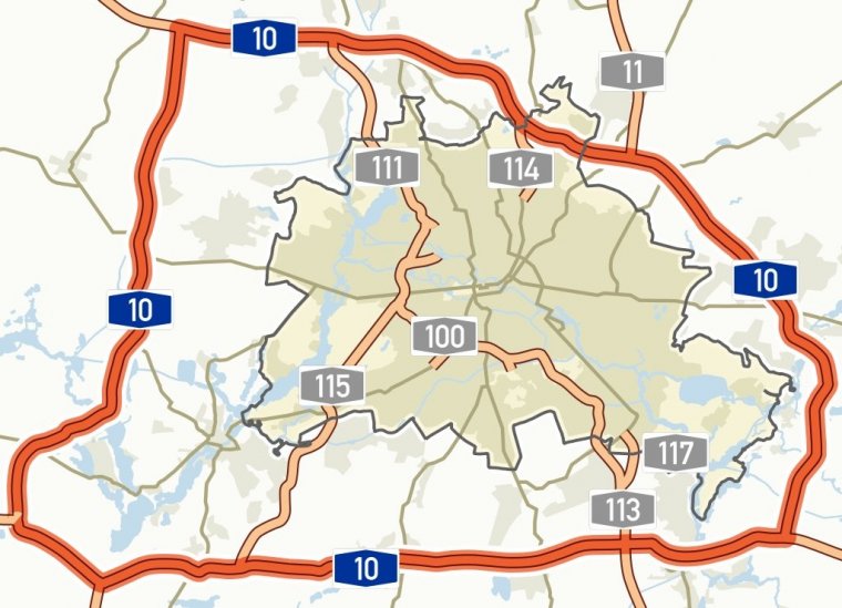
Map of Bundesautobahn 10, Germany. ![]()
Bundesautobahn 10 (Federal Motorway 10, short form Autobahn 10, abbreviated as BAB 10 or A 10) is an orbital motorway around the German capital city of Berlin. Colloquially called Berliner Ring, it is predominantly located in the state of Brandenburg, with a short stretch of 5 km (3 miles) in Berlin itself. It should not be confused with the Berliner Stadtring (Bundesautobahn 100) around Berlin's inner city.
With a total length of 196 km (122 miles), the BAB 10 is the longest orbital in Europe, being 8 km (5 miles) longer than the M25 motorway around London.
The highway route markers run clockwise from the interchange at Schwanebeck (the former Prenzlau branch-off), where the Bundesautobahn 11 runs to Szczecin, Poland via the Pomellen/Kołbaskowo border crossing and the Polish A6 autostrada.
From here the beltway leads southwards to the Spreeau interchange with the Bundesautobahn 12 to Frankfurt (Oder) and the Polish A2 autostrada.
At the Schönefeld four-way interchange, the Bundesautobahn 13 leads to Dresden and the Bundesautobahn 113 to the Berliner Stadtring and the Berlin city centre via Berlin Brandenburg Airport.
The Berliner Ring then runs westwards to Nuthetal, where the Bundesautobahn 115 (including the former AVUS race track) also links to the Stadtring at the Funkturm Berlin. Next the Bundesautobahn 9 leads to Munich (at the Potsdam interchange) and the Bundesautobahn 2 to the Ruhr area (at Werder).
From here the beltway runs northwards to the Dreieck Havelland interchange with the Bundesautobahn 24 to Hamburg, and finally turns eastwards to the Oranienburg and Pankow interchanges with the Bundesautobahn 111 and Bundesautobahn 114 motorways both leading to the Berliner Stadtring. It again reaches Schwanebeck at km 196.
The beginning and end of the kilometer is the cross Barnim, which until 2013 Dreieck Schwanebeck was called. From there, the A11 from Stettin / Prenzlau joins the A10.
In the direction of the kilometering (clockwise), the A12 leads from the outside at the triangle Spreeau, at the junction Schoenefeld the A13, at the triangle Potsdam the A9, at the triangle Werder the A 2 and at the triangle Havelland the A 24 in the Berliner Ring.
The highway is connected to the Berliner Stadtring (A 100) and other parts of Berlin via the A 111 (Oranienburg), A 114 (Pankow), A 113 (Kreuz Schönefeld) and A 115 (Nuthetal), the northern part is called AVUS known), which open from the inside into the ring.
The junctions Ludwigsfelde-Ost and Berlin-Spandau as well as the Oranienburg cross lead to motorway-like developed federal highways.
Length: 196 km (122 mi)
Junctions
A 11 in Kreuz Barnim
A 12 E30 in Grünheide
A 13 A 113 E55 in Schönefelder Kreuz
A 9 in Potsdam
A 2 E30 in Dreieck Werder
A 24 E26 E55 in Dreieck Havelland
States: Berlin, Brandenburg
Source
• www.wikipedia.org
YOU MAY ALSO LIKE


 If you own or manage a travel-related business such as a hotel, a bed-and-breakfast, a restaurant, a pub or a cafeteria, you can create a web page for your business for free on Titi Tudorancea Travel Info. » |