| Published in Tourist Info / Highways |
Autovía A-23, Autovía Mudéjar, Spain
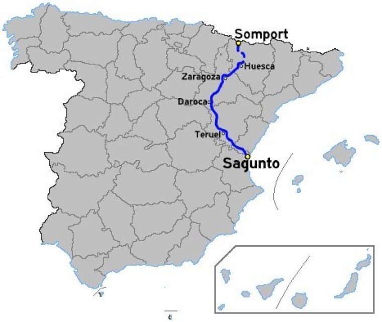
Map of Autovía A-23, Spain. ![]()
The Autovía A-23 is a motorway in Aragon, Spain with an average speed limit of 120 km/h. The A-23 also has European nomenclature, as part of the European route E07, which connects Pau, southern France, with Zaragoza.
In the French section, the route is called RN134, which connects Pau to Oloron-Sainte-Marie and Spain.
A-23 is an upgrade of the N-330 and N-234. Presently, it starts in the province of Huesca then leads south to Zaragoza. Hereafter, it follows the rio Jiloca south to Teruel through the Sierra d'Espada to the coast at Sagunto. Plans call for the freeway to reach the French border at Somport. The freeway is also known as Autovía Valencia-Francia or Autovía Sagunto-Somport.
The A-23 runs through the corridors of the N-234, between Sagunto and Retascón and the N-330 between Retascón and Jaca. Though, except for two small sections, the whole layout of the road is new and independent of national roads. One section is at 10 km from Viver and Barracks (Ragudo rise), and the other section is about 30 km from the complicated port to save the Pyrenean the Monrepós which is the most expensive portion of the entire highway.
The stretch between Zaragoza and Huesca presents problems for light trucks when strong wind gusts occur in Cierzo.
Length: 440.1 km (273.5 mi)
Junctions
From Sagunto
To Somport
Sections
1. Sagunto-Soneja. Length: 16.9 km
2. Soneja-Segorbe. Length: 9.5 km
3. Variante de Segorbe. Length: 3,6 km
4. Segorbe-Río Palancia. Length: 6.6 km
5. Río Palancia-Viver. Length: 10.2 km
6. Viver-Barracas. Length: 14.2 km
7. Barracas-Sarrión. Length: 18.2 km
8. Sarrión- Escandón. Length: 20.6 km
9. Escandón -Teruel. Length: 16.6 km
10. Teruel-Santa Eulalia del Campo. Length: 26.8 km
11. Santa Eulalia del Campo-Monreal del Campo. Length: 21.9 km
12. Monreal del Campo-Calamocha. Length: 14.7 km
13. Calamocha- Romanos. Length: 27.8 km
14. Romanos-Mainar. Length: 11.8 km
15. Mainar-Paniza. Length: 13 km
16. Paniza-Torrubia (Muel). Length: 16.8 km
17. Torrubia (Muel)-María de Huerva. Length: 13.1 km
18. María de Huerva-Zaragoza Sur. Length: 11.6 km
19. Zaragoza Sur-Zaragoza Este. Length: 14.2 km
20. Zaragoza Este-Villanueva de Gállego. Length: 9.5 km
21. Villanueva de Gállego-Zuera. Length: 17 km
22. Zuera-Almudévar. Length: 22 km
23. Almudévar-Huesca. Length: 21.7 km
24. Huesca-Nueno. Length: 12.3 km
25. Nueno-Congosto de Isuela. Length: 5 km
26. Congosto de Isuela-Arguis. Length: 3.3 km. Designation: N-330
27. Arguis-Alto de Monrepós. Length: 3.2 km
28. Alto de Monrepós-Caldearenas. Length: 4.1 km
29. Caldearenas-Lanave. Length: 12 km
30. Lanave-Embalse de Jabarrella. Length: 7 km
31. Embalse de Jabarrella-Sabiñánigo Sur. Length: 2.2 km
32. Sabiñánigo Sur-Sabiñánigo Este. Length: 3 km
33. Sabiñánigo Este-Sabiñánigo Oeste. Length: 6.9 km. Designation: N-330
34. Sabiñánigo Oeste-Jaca Este. Length: 9.6 km
35. Variante de Jaca (Jaca Este-Jaca Norte. Length: 8.04 km. Designation: N-330
36. Jaca Oeste-Somport. Length: 19 km. Designation: N-330
37. Túnel de Somport. Length: 8.608 km. Designation: N-330
Source
• www.wikipedia.org
YOU MAY ALSO LIKE

 If you own or manage a travel-related business such as a hotel, a bed-and-breakfast, a restaurant, a pub or a cafeteria, you can create a web page for your business for free on Titi Tudorancea Travel Info. » |