| Published in Tourist Info / Highways |
A29 autoroute, France
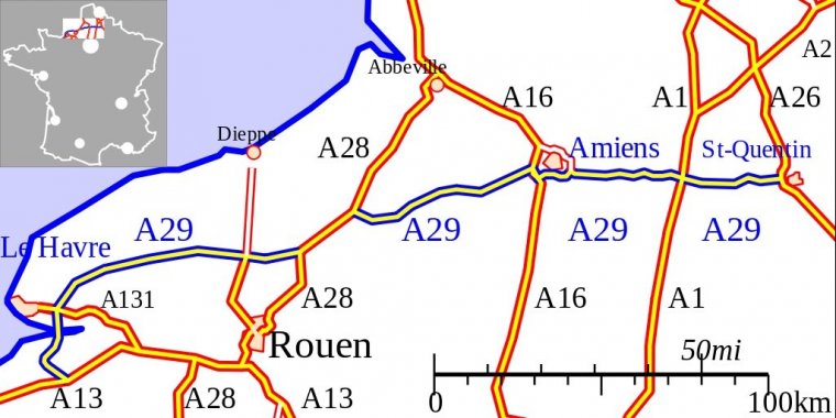
Map of French A29 motorway. ![]()
The A 29 is a motorway in Normandy and Picardy, northwestern and northern France. The road is also part of European route E44. From its western interchange with the A28 autoroute until its junction with the A26 autoroute, part of the A29 also forms the northern section of the Grand contournement de Paris.
The road connects the port of Le Havre with the A 26 at Saint-Quentin. It also has junctions with the A 13, A 131, A 16, A 28, and A 1 autoroutes.
Length: 264 km (164 mi)
Speed limit: France has the following speed limits for limited access roads classified as motorways:
• Under normal conditions - 130 km/h (80 mph)
• In rain or wet road conditions - 110 km/h (70 mph)
• In heavy fog or snowy/icy conditions - 50 km/h (30 mph)
Limited access roads classified as express roads have lower speed limit (90 or 110 km/h, 55 or 70 mph).
In normal conditions, there is a minimum speed of 80 km/h (50 mph) in the lane most left (no minimum speed on the others' right lanes, but speed should be adapted for each situation: not too slow).
Junctions
— 01 Exchange A 13-A 29 Autoroute starts with junction on the A 13, to Caen (west) and Rouen (east).
— 01 Fourneville km 10 Towns served: Deauville
— 02 Équemauville km 13 Towns served: Équemauville, Gonneville-sur-Honfleur
— 03 km 17 Honfleur Towns served: Honfleur Road becomes the D 929
— Pont de Normandie Toll Bridge
— 05 km 22 Rogerville A 131 Towns Served: Le Havre and Rouen A 131 to A 13.
— 06 km 31Épretot Towns served: Saint-Romain-de-Colbosc
— Péage Épretot
— 07 km 39 Bolbec Towns served: Bolbec
— Service Area: Bolleville
— 08 km 56 Bermonville Towns served: Fécamp
— Rest Area: Écretteville-lès-Baons
— 05 A 150, A 150 spur to N 15 Towns served Yvetot.
— 09 km 72 Caillebourg Towns served: Yerville
— Rest Area: Saint-Martin-aux-Arbres
— 05 km 89 A 151, A 151 and N 27 Dieppe (north) Rouen (south) to A 150.
— Péage Cottevrard
— 05 km 105 A 28, Motorway merges with the A 28 northbound. Rouen (South), Abbeville (north)
— 05 km 131 A 28, A2 9 Motorway begins again at a junction after Neufchâtel-en-Bray
— 11 km 134 Mortemer Towns served: N 29, Neufchâtel-en-Bray
— 12 km 151 Haudricourt Towns served: N 29, Aumale
— Péage Haudricourt
— 13 km 168 Poix-de-Picardie Towns served: Poix-de-Picardie
— 05 km 188 A 16, The A 29 Motorway merges with the A 16 southbound towards Paris (south), Calais (north)
— 05 km 188 A 16, The A 29 Motorway begins again 4km to the south
— Péage Dury
— 31 km 195 Dury Towns served: Amiens
— 32 km 198 Amiens-sud Towns served: Amiens
— 33 km 201 Cagny Towns served: Amiens
— 34 km 203 Junction with N 25 and A 29
— 51 km 205 Boves Towns served: Amiens, Roye
— Péage Boves
— Service Area: Villers-Bretonneux
— 53 km 246 A 1-A 29 A 1 Paris (south), Lille
— 51 km 257 Ennemain Towns served: Ennemain
— 05 km 268 A 26-A 29 The A 29 merges with the A 26 at Saint-Quentin Calais (north), Reims (south)
Source
• www.wikipedia.org
YOU MAY ALSO LIKE


 If you own or manage a travel-related business such as a hotel, a bed-and-breakfast, a restaurant, a pub or a cafeteria, you can create a web page for your business for free on Titi Tudorancea Travel Info. » |